- Drumquin
-
Coordinates: 54°36′58″N 7°29′26″W / 54.616095°N 7.490444°W
Drumquin Irish: Druim Caoin 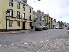
 Drumquin
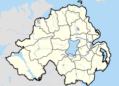
Drumquin shown within Northern IrelandPopulation 291 (2001) Irish grid reference H329743 - Belfast 77 miles (124 km) District Omagh County County Tyrone Country Northern Ireland Sovereign state United Kingdom Post town OMAGH Postcode district BT78 Dialling code 028, +44 28 EU Parliament Northern Ireland UK Parliament West Tyrone NI Assembly West Tyrone List of places: UK • Northern Ireland • Tyrone Drumquin (from Irish: Druim Caoin, meaning "pleasant ridge")[1] is a small village and townland in County Tyrone, Northern Ireland. It lies between Omagh and Castlederg, on the banks of the Drumquin River (Fairywater). It had a population of 1923 people in the 2001 Census.
Contents
History
It has a rich and varied historical legacy with a Neolithic stone circle, a Holy Well, and the Giant's Stone on Dooish Mountain.
Those who are acquainted with the works of the noted Irish writer Benedict Kiely will be aware of his many references to the Drumquin district, with which he has family connections on his mothers side. In 1802, the countryside around Drumquin was described as one continuous scene of dreary mountains. However, the traveller did point out that forty years before that a rich coalmine had been opened at Drumquin and a canal opened to transport the coal. Drumquin has been in existence since 1211. Sir John Davies founded the village itself in 1617, and the same gentleman built Castle Curlews, later called Castle Kirlish, the remains of which can be seen in the town land of that name. His agent was a man called Bradley, one of whose family was responsible in later times for the building of the fine stone house, which is a feature of the village today. It is interesting to note that Castle Kirlish was joined to Castlederg Castle by a straight causeway, which was seven miles (11 km) long. Traces of this causeway could still be observed in 1837.
Drumquin was also a stageing town in the 19th and early 20th century for coaches and travellers who were making their way to Derry from Omagh and vice versa. As a result of this the village flourished and hosted a hotel and several shops.
Felix Kearney immortalised this area with songs such as "The Hills Above Drumquin" and others.
On 26 August 1920, during the Irish War of Independence, the Irish Republican Army (IRA) attacked the Royal Irish Constabulary (RIC) barracks in Drumquin. One RIC constable and one IRA volunteer were killed.[2]
Geography
 Bell tower at St Patrick's church, Drumquin
The geography of the area is a mixture of flat fertile lands that clings to the banks of the Fairywater and steep rolling hills. There is also significant forests' to be found to the southwest of the village. Lough Bradan is also located roughly 7 miles from the village. The land is also covered in numerous rivers and streams and two rivers in particular meet on the outskirts of the village to form the river Fairywater.
The village itself is dominated by Dooish Mountain which is the highest point in the area. Close to the village Sloughan Glen Waterfalls can be found these rest in a deep ravine. Beyond the townland of Bradan lies miles of wet bogland that streches to the border with County Fermanagh. In the area of the glen the land rises dramatically before falling again into the Fermanagh countryside. The area in general is also dotted with several quarries the biggest of these lying 2 miles outside of the village itself.
Places of Interest
- Lough Bradan is an area of outstanding beauty located roughly 7 miles from the village. The lough is a well known fishing location and is regularly stocked with trout. The lough is open to fishing from the months of may through to September. The area around the lough also has numerous walking trails the longest of these taking you right around the diameter of the lake itself and into wooded areas before joining the main road back to the lough. There are several benches to be found near the lough's edge and these are ideal for pinicking. As the lough is bordered on three sides by forest it is not uncommon to see deer and stags roaming the area.
- Sloughan Glen Waterfalls are located roughly 4 miles from the village. This is a popular tourist location and it is common to see people pinicking throughout the year. The waterfalls themselves lie in a deep ravine and can be accessed by a series of walkways and steps. The layout of the walk is such that the visitor comes across the smaller waterfall first this can be viewed from ground level. The steps can then be taken to view the first waterfall from a high walkway. Upon following this walkway further and climbing several more steps the larger waterfall can be viewed from atop. The best time to view the waterfalls is after heavy rainfall when the waterfalls are at their strongest. There are several picnic areas in the Waterfalls and a sufficient size car park making access good.
- The stone monument on Dooish Mountain was built in late 1990s and can be accessed by a tough mountain walk from either east or west face of mountain. The monument itself is built in a traditional way with no modern tools or equipment and is an interesting place to visit. On top of the mountain itself you will be confronted by spectacular views of the village of drumquin and the surrounding countyside. Being the highest mountain for miles you have an unobstructed view and on a good day can see for miles upon miles in any direction.
Sport
- Drumquin Wolfe Tones is the local Gaelic Athletic Association club which has been in existence in its traditional form since 1968. Previous clubs have existed in various forms from the early 1930s. Drumquin have also a soccer team, Drumquin United, that has been in operation since 2007.
- Drumquin also plays host to several stages of the World Rally Championship as part of Rally Ireland and has successfully hosted two such races in recent years.
People
- Thomas Buchanan MLA, born in Drumquin, is a Democratic Unionist Party MLA for West Tyrone in the Northern Ireland Assembly.
References
Categories:- Villages in County Tyrone


Wikimedia Foundation. 2010.