- Oldham
-
For other uses, see Oldham (disambiguation).For the larger local government district, see Metropolitan Borough of Oldham.
Coordinates: 53°32′40″N 2°07′01″W / 53.5444°N 2.1169°W
Oldham 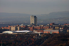
View of Oldham town centre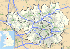
 Oldham
Oldham shown within Greater ManchesterArea 6.9 sq mi (18 km2) Population 103,544 (2001 Census) - Density 5,785 /sq mi (2,234 /km2) OS grid reference SD922053 - London 164 mi (264 km) SSE Metropolitan borough Oldham Metropolitan county Greater Manchester Region North West Country England Sovereign state United Kingdom Post town OLDHAM Postcode district OL1-OL2, OL4, OL8-OL9 Dialling code 0161 Police Greater Manchester Fire Greater Manchester Ambulance North West EU Parliament North West England UK Parliament Oldham East and Saddleworth Oldham West and Royton List of places: UK • England • Greater Manchester Oldham
 /ˈɒldəm/ is a large town in Greater Manchester, England.[1] It lies amid the Pennines on elevated ground between the rivers Irk and Medlock, 5.3 miles (8.5 km) south-southeast of Rochdale, and 6.9 miles (11.1 km) northeast of the city of Manchester. Oldham is surrounded by several smaller settlements which together form the Metropolitan Borough of Oldham, of which Oldham is the administrative centre.
Historically a part of Lancashire, and with little early history to speak of, Oldham rose to prominence during the 19th century as an international centre of textile manufacture. It was a boomtown of the Industrial Revolution, and among the first ever industrialised towns, rapidly becoming "one of the most important centres of cotton and textile industries in England".[2] At its zenith, it was the most productive cotton spinning mill town in the world,[3][4] spinning more cotton than France and Germany combined.[5] Oldham's textile industry began to fall into decline during the mid-20th century, and its last mill closed in 1998.
The demise of textile processing in Oldham depressed the local economy.[6] Today Oldham is a predominantly residential town, and a centre for further education and the performing arts.[7] It is, however, still distinguished architecturally by the surviving cotton mills and other buildings associated with that industry. The town's population of 103,544[8] lives in an area of around 26 square miles (67 km2).[9]
Contents
History
Main article: History of OldhamToponymy
The toponymy of Oldham (/ˈoʊldəm/) seems to imply "old village or place" from Eald (Saxon) signifying oldness or antiquity, and Ham (Saxon) a house, farm or hamlet.[10] However, Oldham is known to be a derivative of Aldehulme; undoubtedly an Old Norse name.[11] It is believed to be derived from the Old English ald combined with the Old Norse holmi or holmr, meaning "old promontory or outcrop", possibly describing the town's hilltop position.[11] It has alternatively been suggested that it may mean "holm or hulme of a farmer named Alda".[11] The name is understood to date from 865, during the period of the Danelaw.[11]
Early history
The earliest known evidence of a human presence in what is now Oldham is attested by the discovery of Neolithic flint arrow-heads and workings found at Werneth and Besom Hill, implying habitation 7–10,000 years ago.[11] Evidence of later Roman and Celtic activity is confirmed by an ancient Roman road and Bronze Age archaeological relics found at various sites within the town.[11] Although Anglo-Saxons occupied territory around the area centuries earlier,[11][12] Oldham as a permanent, named place of dwelling is believed to date from 865, when Danish invaders established a settlement called Aldehulme.[11][13]
From its founding in the 9th century until the Industrial Revolution, Oldham is believed to have been little more than a scattering of small and insignificant settlements spread across the moorland and dirt tracks which linked Manchester to York.[11][14] Although not mentioned in the Domesday Book, Oldham does appear in legal documents from the Middle Ages, invariably recorded as territory under the control of minor ruling families and barons.[13] In the 13th century, Oldham was documented as a manor held from The Crown by a family surnamed Oldham, whose seat was at Werneth Hall.[10]
Industrial Revolution and cotton
 Oldham from Glodwick by James Howe Carse (1831), depicts the early skyline and industrial activities of Oldham. All the green space has since been urbanised.
Much of Oldham's history is concerned with textile manufacture during the Industrial Revolution; it has been said that "if ever the Industrial Revolution placed a town firmly and squarely on the map of the world, that town is Oldham."[6] Oldham's soils were too thin and poor to sustain crop growing, and so for decades prior to industrialisation the area was used for grazing sheep, which provided the raw material for a local woollen weaving trade.[10]
By 1756, Oldham had emerged as centre of the hatting industry in England. The rough felt used in the production process is the origin of the term "Owdham Roughyed" a nickname for people from Oldham.[11] It was not until the last quarter of the 18th century that Oldham changed from being a cottage industry township producing woollen garments via domestic manual labour, to a sprawling industrial metropolis of textile factories.[10] The climate, geology, and topography of Oldham were unrelenting constraints upon the social and economic activities of the human inhabitants.[15] Located 700 feet (213 m) above sea level with no major river or visible natural resources, Oldham had poor geographic attributes compared with other settlements for investors and their engineers. As a result, Oldham played no part in the initial period of the Industrial Revolution,[3][14] although it did later become seen as obvious territory to industrialise because of its convenient position between the labour forces of Manchester and southwest Yorkshire.[16]
Cotton spinning and milling were introduced to Oldham when its first mill, Lees Hall, was built by William Clegg in about 1778, the beginning of a spiralling process of urbanisation and socioeconomic transformation.[3] Within a year, 11 other mills had been constructed,[11] and by 1818 there were 19 – not a large number in comparison with other local settlements.[14] Oldham's small local population was greatly increased by the mass migration of workers from outlying villages,[11] resulting in a population increase from just over 12,000 in 1801 to 137,000 in 1901.[14] The speed of this urban growth meant that Oldham, with little pre-industrial history to speak of, was effectively born as a factory town.
 Royd mill, built in 1907,[3] and seen here in 1983, was one of Oldham's peak of 360 textile mills which operated night and day.
Oldham became the world's manufacturing centre for cotton spinning in the second half of the 19th century.[14] In 1851, over 30% of Oldham's population was employed within the textile sector, compared to 5% across Great Britain.[16] It overtook the major urban centres of Manchester and Bolton as the result of a mill building boom in the 1860s and 1870s, a period during which Oldham became the most productive cotton-spinning town in the world.[14] In 1871 Oldham had more spindles than any country in the world except the United States, and in 1909, was spinning more cotton than France and Germany combined.[5] By 1911 there were 16.4 million spindles in Oldham, compared with a total of 58 million in the United Kingdom and 143.5 million in the world; in 1928, with the construction of the UK's largest textile factory Oldham reached its manufacturing zenith.[14] At its peak, there were over 360 mills, operating night and day;[17][18] Oldham's townscape was dominated by distinctive rectangular brick-built mills.[19] Oldham was hit hard by the Lancashire Cotton Famine of 1861–1865, when supplies of raw cotton from the United States were cut off. Wholly reliant upon the textile industry, the cotton famine created chronic unemployment in the town.[20] By 1863 a committee had been formed, and with aid from central government, land was purchased with the intention of employing local cotton workers to construct Alexandra Park, which opened on 28 August 1865.[20] Said to have over-relied upon the textile sector,[6][13] as the importation of cheaper foreign yarns grew during the 20th century, Oldham's economy declined into a depression, although it was not until 1964 that Oldham ceased to be the largest centre of cotton spinning.[6][14][21] In spite of efforts to increase the efficiency and competitiveness of its production, the last cotton spun in the town was in 1998.[14]
Engineering
Facilitated by its flourishing textile industry, Oldham developed extensive structural and mechanical engineering sectors during the 18th and 19th centuries. The manufacture of spinning and weaving machinery in Oldham belongs to the last decade of the 19th century, when it became a leading centre in the field of engineering.[11] The Platt Brothers, originated in nearby Dobcross village, but moved to Oldham. They were pioneers of cotton-spinning machinery, developing innovatory products which enabled the mass-production of cotton yarn. Platt Brothers became the largest textile machine makers in the world, employing over 15,000 people in the 1890s,[22] twice the number of their nearest rivals Dobson & Barlow in Bolton and Asa Lees on Greenacres Moor.[18] They were keen investors in the local area and at one time, were supporting 42% of the population.[22] The centre of the company lay at the New Hartford Works in Werneth, a massive complex of buildings and internal railways on a site overlooking Manchester. The railway station which served this site later formed the basis of Oldham Werneth railway station, which together with the main building exists to this day. Platts gained prestigious awards from around the world,[20] and were heavily involved with local politics and civic pride in Oldham.[22] John and James Platt were the largest subscribers for promoting Oldham from a township to a Borough, pledging £100 (more than double the next largest sum) in advance towards any expenses which may have been incurred by the Royal Charter.[11] In 1854 John Platt was made the (fourth) Mayor of Oldham, an office he was to hold twice more in 1855–56 and 1861–62.[23] John Platt was elected in 1865 to become Member of Parliament for Oldham, and was re-elected in 1868; he remained in office until his death in 1872.[11] A bronze statue of Platt existed in the town centre for years, though was moved to Alexandra Park. There have been recommendations for it to be returned to the town centre.[7]
Abraham Henthorn Stott, the son of a stonemason, was born in nearby Shaw and Crompton in 1822.[3] He served a seven-year apprenticeship with Sir Charles Barry, before starting a structural engineering practice in Oldham in 1847 that went on to become the pre-eminent mill architect firm in Lancashire.[3] Philip Sydney Stott, third son of Abraham and later titled as Sir Philip Stott, 1st Baronet, was the most prominent and famous of the Stott mill architects.[3] He established his own practice in 1883 and designed over a hundred mills in several countries. His factories, which improved upon his father's fireproof mills, accounted for a 40% increase in Oldham's spindles between 1887 and 1914.[3]
Although textile-related engineering declined with the processing industry, leading to the demise of both Stotts and Platts, other engineering firms existed, notably electrical and later electronic engineers Ferranti in 1896.[18] Ferranti went into receivership in 1993, but some of its former works continue in other hands. Part of the original Hollinwood site was operated by Siemens Metering and Semiconductor divisions.[18] The remainder of the site is occupied by Mirror Colour Print Ltd; the printing division of the Trinity Mirror group, which prints and distributes thirty-six major newspapers, and employs five hundred staff.[24][25]
Coal mining
On the back of the Industrial Revolution, Oldham developed an extensive coal mining sector, correlated to supporting the local cotton industry and the town's inhabitants, though there is evidence of small scale coal mining in the area as early as the 16th century.[26] The Oldham Coalfield stretched from Royton in the north to Bardsley in the south and in addition to Oldham, included the towns of Middleton and Chadderton to the west.[26] The Oldham Coalfield was the site of over 150 collieries during its recorded history.[26] Although some contemporary sources suggest there was coal mining in Oldham at a commercial scale by 1738,[26] older sources attribute the commercial expansion of coal mining with the arrival in the town of two Welsh labourers, John Evans and William Jones, around 1770.[11] Foreseeing the growth in demand for coal as a source of motive and steam power, they acquired colliery rights for Oldham, which by 1771 had 14 colliers.[11] The mines were largely to the southwest of the town around Hollinwood and Werneth and provided enough coal to accelerate Oldham's rapid development at the centre of the cotton boom. At its height in the mid-19th century, when it was dominated by the Lees and Jones families, Oldham coal was mainly sourced from many small collieries whose lives varied from a few years to many decades, although two of the four largest collieries survived to nationalisation.[26][27] In 1851, collieries employed over 2,000 men in Oldham,[27] although the amount of coal in the town was somewhat overestimated however, and production began to decline even before that of the local spinning industry.[26] Today, the only visible remnants of the mines are disused shafts and boreholes.[26]
Social history
Oldham's social history, like that of other former unenfranchised towns, is marked by politicised civil disturbances, as well as events related to the Luddite, Suffragette and other Labour movements from the working classes.[9][22] There has been a significant presence of "friendly societies".[11][28] It has been put that the people of Oldham became radical in politics in the early part of the 19th century, and movements suspected of sedition found patronage in the town.[9] Oldham was frequently disturbed by bread and labour riots, facilitated by periods of scarcity and the disturbance of employment following the introduction of cotton-spinning machinery.[9] On 20 April 1812, a "large crowd of riotous individuals" compelled local retailers to sell foods at a loss, whilst on the same day Luddites numbering in their thousands, many of whom were from Oldham, attacked a cotton mill in nearby Middleton.[10] On 16 August 1819, Oldham sent a contingent estimated at well above 10,000 to hear speakers in St Peter's Fields at Manchester discuss political reform.[29] It was the largest contingent sent to Manchester.[30] John Lees, a cotton operative and ex-soldier who had fought at Waterloo, was one of the fifteen victims of the Peterloo Massacre which followed. The 'Oldham inquest' which proceeded the massacre was anxiously watched; the Court of King's Bench, however, decided that the proceedings were irregular, and the jury were discharged without giving a verdict.[9]
Annie Kenney, born in nearby Springhead, and who worked in Oldham's cotton mills, was a notable of the Suffragette movement credited with sparking off suffragette militancy when she heckled Winston Churchill, and later (with Emmeline Pankhurst) the first Suffragist to be imprisoned. Oldham Women's Suffrage Society was established in 1910 with Margery Lees as president and quickly joined the Manchester and District Federation of the National Union of Women's Suffrage Societies.[31] The Chartist and Co-operative movements had strong support in the town, whilst many Oldhamers protested against the emancipation of slaves.[22] The Riot Act was read in 1852 on election day following a mass public brawl over the Reform Act,[32] and irregularities with parliamentary candidate nominations.[11]
For three days in late May 2001, Oldham became the centre of national and international media attention. Following high profile race-related conflicts, and long-term underlying racial tensions between local White British and Asian communities, major riots broke out in the town. Occurring with particular intensity in the Glodwick area of the town, the Oldham riots were the worst racially motivated riots in the United Kingdom for fifteen years prior, briefly eclipsing the sectarian violence in Northern Ireland in the media.[33] At least 20 people were injured in the riots, including 15 police officers, and 37 people were arrested. Similar riots took place in other towns in northern England over the following days and weeks. The 2001 riots prompted governmental and independent inquiries, which collectively agreed on community relations improvements and considerable regeneration schemes for the town.[33][34]
Governance
Civic history
 The coat of arms of the former County Borough of Oldham council, granted 7 November 1894, based upon those of an ancient local family surnamed Oldham. The owls suggest that the family, like the town, called itself 'Owdham', and adopted the birds in allusion to its name. The motto "Sapere aude" refers to the owls.[11][35]
Lying within the historic county boundaries of Lancashire since the early 12th century, Oldham was recorded in 1212 as being one of five parts of the thegnage estate of Kaskenmoor, which was held on behalf of King John by Roger de Montbegon and William de Nevill.[9][11] The other parts of this estate were Crompton, Glodwick, Sholver, and Werneth.[12] Oldham later formed a township within the ancient ecclesiastical parish of Prestwich-cum-Oldham, in the hundred of Salford.[1][9]
In 1826 commissioners for the social and economic improvement of Oldham were established.[1] The town was made part of a parliamentary borough, in 1832, though it was in 1849 when Oldham was incorporated as a municipal borough, giving it borough status in the United Kingdom,[1][11] and in 1850 the Borough Council obtained the powers of the improvement commissioners.[1] In 1880, parts of the Hollinwood and Crossbank areas of Chadderton and Ashton-under-Lyne townships were added to the Borough of Oldham.[1] Oldham Above Town and Oldham Below Town were, from 1851 until c.1881, statistical units used for the gathering and organising of civil registration information, and output of census data.
The Local Government Act 1888 created elected county councils to administer services throughout England and Wales. Where a municipal borough had a population of more than 50,000 at the 1881 Census it was created a county borough, with the powers and duties of both a borough and county council.[36] As Oldham had an 1881 population of 111,343 it duly became a county borough on 1 April 1889. The borough, while independent of Lancashire County Council for local government, remained part of the county for purposes such as the administration of justice and lieutenancy.[1][37]
In 1951 parts of the Limehurst Rural District were added to the County Borough of Oldham, and in 1954 further parts of the same district added to it on its abolition.[36] Since 1961, Oldham has been twinned with Kranj in Slovenia.[38] Under the Local Government Act 1972, the town's autonomous County borough status was abolished, and Oldham has, since 1 April 1974, formed part of the Metropolitan Borough of Oldham, within the Metropolitan county of Greater Manchester.[1]
Parliamentary representation
The boundaries of two parliamentary constituencies divide Oldham: Oldham East and Saddleworth, and Oldham West and Royton (which includes the town centre), represented by Labour Members of Parliament Debbie Abrahams and Michael Meacher respectively.[39][40][41]
Created as a parliamentary borough in 1832, Oldham's first parliamentary representatives were the radicals William Cobbett and John Fielden.[42] Winston Churchill began his political career in Oldham. Although unsuccessful at his first attempt in 1899, Churchill was elected as the member of Parliament for the Oldham parliamentary borough constituency in the 1900 general election.[43] He held the constituency for the Conservative Party until the 1906 general election, when he won the election for Manchester North West as a Liberal MP. After he became the Prime Minister of the United Kingdom in 1940, Churchill was made a Honorary Freeman of the Borough of Oldham, on 2 April 1941.[11]
Geography
Further information: Geography of Greater ManchesterOldham Climate chart (explanation) J F M A M J J A S O N D 70615071609350124601577018107020128020127017108014880948072Average max. and min. temperatures in °C Precipitation totals in mm Source: Records and averages, Yahoo! Weather, 2007, http://weather.yahoo.com/climo/UKXX0105_c.html Imperial conversion J F M A M J J A S O N D 2.84334245342.44837254392.459452.864502.868543.168542.863503.157463.148393.14536Average max. and min. temperatures in °F Precipitation totals in inches  A map of Oldham, and surrounding area.
At 53°32′39″N 2°7′0.8″W / 53.54417°N 2.116889°W (53.5444°, -2.1169°), and 164 miles (264 km) north-northwest of London, Oldham stands 700 feet (213 m) above sea level, 6.9 miles (11.1 km) northeast of Manchester city centre, on elevated ground between the rivers Irk and Medlock. Saddleworth and the South Pennines are close to the east, whilst on all other sides, Oldham is bound by smaller towns, including Ashton-under-Lyne, Chadderton, Failsworth, Royton and Shaw and Crompton, with little or no green space between them. Oldham experiences a temperate maritime climate, like much of the British Isles, with relatively cool summers and mild winters. There is regular but generally light precipitation throughout the year.[15]
Oldham's topography is characterised by its rugged, elevated Pennine terrain.[3][44] It has an area of 6.91 square miles (17.90 km2).[8] The geology of Oldham is represented by the Millstone Grit and Coal Measures series of rocks.[15] The River Beal, flowing northwards, forms the boundary between Oldham on one side and Royton and Shaw and Crompton on the other.
To the east of this river the surface rises to a height of 1,225 feet (373 m) at Woodward Hill, on the border with the parish of Saddleworth.[9] The rest of the surface is hilly, the average height decreasing towards the southwest to Failsworth and the city of Manchester. The ridge called Oldham Edge, 800 feet (244 m) high, comes southward from Royton into the centre of the town.[9]
 Oldham's irregularly constructed built environment is characterised by its red-brick cotton mills and surrounding terraced houses.
Oldham's built environment is characterised by its 19th-century red-brick terraced houses, the infrastructure that was built to support these and the town's former cotton mills – which mark the town's skyline.[21] The urban structure of Oldham is irregular when compared to most towns in England, its form restricted in places by its hilly upland terrain.[9][44] There are irregularly constructed residential dwellings and streets loosely centred around a central business district in the town centre, which is the local centre of commerce. In 1849, Angus Reach of Inverness said:
The visitor to Oldham will find it essentially a mean-looking straggling town, built upon both sides and crowning the ridge of one of the outlying spurs which branch from Manchester, the neighbouring 'backbone of England'. The whole place has a shabby underdone look. The general appearance of the operatives' houses is filthy and smouldering.[45]—Angus Reach, Morning Chronicle, 1849In the 1870s, John Marius Wilson described Oldham as consisting of:
... numerous streets, and contains numerous fine buildings, both public and private; but, in a general view, is irregularly constructed, presents the dingy aspect of a crowded seat of manufacture, and is more notable for factories than for any other feature.[42]—John Marius Wilson, Imperial Gazetteer of England and Wales (1870–1872)Although Oldham had a thriving economy during the 19th century, the local merchants were broadly reluctant to spend on civic institutions, and so the town lacks the grandeur seen in comparable nearby towns like Bolton or Huddersfield;[7][46] public expenditure was seen as an overhead that undermined the competitiveness of the town.[22] Subsequently, Oldham's architecture has been described as "mediocre".[46] The town has no listed buildings with a Grade I rating.[47]
There is a mixture of high-density urban areas, suburbs, semi-rural and rural locations in Oldham. There is some permanent grassland but overwhelmingly the land use in the town is urban. The territory of Oldham is contiguous with other towns on all sides except for a small section along its eastern and southern boundaries, and for purposes of the Office for National Statistics, forms the fourth largest settlement of the Greater Manchester Urban Area,[48][49] the United Kingdom's third largest conurbation. The M60 motorway passes through the southwest of Oldham, through Hollinwood, and a heavy rail line enters Oldham from the same direction, travelling northeast to the town centre before heading northwards through Derker towards Shaw and Crompton.

A panorama of Oldham looking from Hartshead Pike toward the south east. Divisions and suburbs
 Fredrick Street, in Werneth. Much of Oldham's housing stock is two-up-two-down rows of terraced houses, a reminder of its mill town history.
Many of Oldham's present divisions and suburbs have origins as pre-industrial hamlets, manorial commons and ancient chapelries.[11] Some, such as Moorside, exist as recently constructed residential suburbia, whilst places like Hollinwood exist as electoral wards[50] and thoroughly industrialised districts. Throughout most of its recorded history, Oldham was surrounded by large swathes of moorland, which is reflected in the placenames of Moorside, Greenacres moor, Littlemoor, Northmoor among others.
A large portion of Oldham's residences are "low value"[7] Victorian era Accrington red-brick terraced houses in a row formation,[22] built for the most part from 1870 to 1920, to house the town's cotton mill workers.[32] There is more modern housing in the semi-rural east of the town, in areas such as Moorside,[51] although terraces are found in almost all parts of Oldham.
One of the oldest recorded named places of Oldham is Hathershaw, occurring in a deed for 1280 with the spelling Halselinechaw Clugh.[11] Existing as a manor in the 15th century, Hathershaw Hall was the home of a Royalist family in the 17th century who lost part of their possessions due to the English Civil War.[11] Waterhead, an upland area in the east of Oldham, traces its roots to a water cornmill over the border in Lees.[13]
Recorded originally as Watergate and Waterhead Milne, it was for a long time a hamlet in the parish of Oldham that formed a significant part of the Oldham Above Town registration sub-district. Derker was recorded as a place of residence in 1604 with the name Dirtcar.[11] Bound by Higginshaw to the north, Derker is the location of Derker railway station and, said to have terraced residencies "unsuited to modern needs", is currently being redeveloped as part of the Housing Market Renewal Initiative.[52]
Coldhurst, an area along Oldham's northern boundary with Royton, was once a chapelry and the site of considerable industry and commerce, including coal mining, cotton spinning and hat manufacture.[53] It is said to have been the scene of an action in the English Civil War in which the Parliamentarians were defeated.[53]
Areas and suburbs of Oldham Abbeyhills · Alt · Bardsley · Barrowshaw · Clarksfield · Coldhurst · Coppice · Derker · Fitton Hill · Freehold · Garden Suburb · Glodwick · Greenacres · Hathershaw · Higginshaw · Hollinwood · Limeside · Moorside · Mumps · Salem · Sholver · Waterhead · Watersheddings · Werneth · WestwoodDemography
Further information: Demography of Greater ManchesterOldham compared UK Census 2001 Oldham1 Oldham (Met. District) England Total population 103,5442 217,273 49,138,831 Foreign born 15% 8.2% 9.2% White British 71% 86% 92% Asian 27% 12% 4.6% Black 0.9% 0.6% 2.3% Christian 58% 73% 72% Muslim 25% 11% 3.1% Hindu 1.1% 0.1% 1.1% No religion 8.3% 8.9% 15% Over 65 years old 12% 14% 16% Unemployed 5.5% 3.7% 3.3% According to data from the United Kingdom Census 2001, Oldham had a total resident population of 103,544, making it the 55th most populous settlement in England, and the 5th most populous settlement of the Greater Manchester Urban Area.[8] This figure in conjunction with its area provides Oldham with a population density of 3,998 people per square mile (1,544 per km²). The local population has been described as broadly "working class"; the middle classes tending to live in outlying settlements.[22]
Oldham, considered as a combination of the 2001 electoral wards of Alexandra,[54] Coldhurst,[55] Hollinwood,[56] St. James,[57] St. Marys,[58] St. Pauls,[59] Waterhead[60] and Werneth,[61] has an average age of 33.5, and compared against the average demography of the United Kingdom, has a high level of people of South Asian heritage, particularly those with roots in Pakistan and Bangladesh. Due to the town's prevalence as an industrial centre and thus a hub for employment, Oldham attracted migrant workers throughout its history, including those from wider-England, Scotland, Ireland and Poland.[62]
During the 1950s and 1960s, in an attempt to fill the shortfall of workers and revitalise local industries, citizens of the wider Commonwealth of Nations were encouraged to migrate to Oldham and other British towns.[62] Many came from the Caribbean and Indian subcontinent and settled throughout the Oldham borough.[62]
Today, Oldham has large communities with heritage from Bangladesh, India, Pakistan and parts of the Caribbean.[62] At the time of the 2001 census, over one in four of its residents identified themselves as from a South Asian or British Asian ethnic group. Cultural divisions along ethnic backgrounds are strong within the town,[22] with poor cross-community integration and cohesion along Asian and white backgrounds.[22]
With only a small local population during medieval times, as a result of the introduction of industry, mass migration of village workers into Oldham occurred,[11] resulting in a population change from under 2,000 in 1714[10][63] to 12,000 in 1801 to 137,000 in 1901.[14] In 1851 its population of 52,820 made Oldham the 12th most populous town in England.[64] The following is a table outlining the population change of the town since 1801, which demonstrates a trend of rapid population growth in the 19th century and, after peaking at 147,483 people in 1911, a trend of general decline in population size during the 20th century.
Year 1801 1811 1821 1831 1841 1851 1861 1871 1881 1891 1901 1911 1921 1931 1939 1951 1961 1971 1981 1991 2001 Population 12,024 16,690 21,662 32,381 42,595 52,820 72,333 82,629 111,349 131,463 137,246 147,483 144,983 140,314 120,511 121,266 115,346 105,922 107,830 103,931 103,544 Sources:
A Vision of Britain through Time
Bateson, H. (1949), A Centenary History of Oldham, p. 232[11]Economy
 Although mass cotton spinning no longer takes place in Oldham, cotton mills mark its skyline, now used as processing and distribution centres.
 The stained glass roof of The Spindles, created by local artist Brian Clarke.
For years Oldham's economy was heavily dependent on manufacturing industry, especially textiles and mechanical engineering.[65][66] Since the deindustrialisation of Oldham in the mid-20th century, these industries have been replaced by home shopping, publishing, healthcare and food processing sectors, though factory-generated employment retains a significant presence.[65] Many of the modern sectors are low-skill and low-wage.[22]
Park Cake Bakeries, recently sold as part of a large shake-up by the Northern Foods Group, have a large food processing centre in Hathershaw, which employs in excess of 1,600 people. Over 90% of the cakes produced go to Marks & Spencer.[67][68] Long existing as an industrial district, Hollinwood is home to the Northern Counties Housing Association,[69] and Mirror Colour Print Ltd; the printing division of the Trinity Mirror group, which prints and distributes 36 major newspapers, and employs 500 staff.[70]
Oldham's town centre contains the highest concentration of retailing, cultural facilities and employment in the Metropolitan Borough of Oldham.[7] It has been extensively redeveloped during the last few decades, and its two shopping centres, Town Square and The Spindles, now provide one of the largest covered retail areas in Greater Manchester.[71] The Spindles (named with reference to textile spindles) is a modern shopping centre with over 40 retailers, banks, building societies and catering outlets. It houses one of Europe's largest stained glass roofs, created by local artist Brian Clarke in celebration of the music of one of Oldham's famous sons, composer and conductor Sir William Walton.[72]
Ferranti Technologies is an electronic, electromechanical and electrical engineering company based in Waterhead.[73]
A number of culinary and medical advances have been developed in Oldham. There are claims that Oldham was the birthplace of the first chip shop.[74][75][76] The sometimes disputed claim of trade in deep-fried chipped potatoes is said to have been started in around 1858–60 from an outlet owned by a John Lees, on what is the present site of Oldham's Tommyfield Market.[76][77][78] In 1900 Oldham had the highest concentration of chip shops in the country; one for every 400 people.[76] Rag Pudding is a savoury dish said to be native to Oldham.[79] Yates Wine Lodge was founded in Oldham by Peter and Simon Yates in 1884.[21]
The tubular bandage was invented and developed in Oldham in 1961.[80] That "vital contribution to advancing medical science" resulted from a collaboration between local firm Seton and a cotton manufacturer in the town.
Landmarks
 Oldham's Old Town Hall, is an unused neo-classical town hall built in 1841.
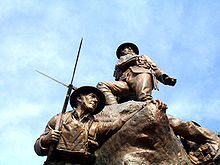 Oldham's war memorial was commissioned in 1919 to "symbolise the spirit of 1914–1918".
 The Civic Centre is the Metropolitan Borough of Oldham's centre of local governance.
 Oldham Parish Church dates from 1830.
Town Hall
Oldham's Old Town Hall is a Grade II listed Georgian neo-classical town hall built in 1841,[81] eight years before Oldham received its borough status.[82] One of the last purpose built town halls in northwest England,[22] it has a tetrastyle Ionic portico, copied from the temple of Ceres, on the River Ilissos, near Athens.[42] Winston Churchill made his inaugural acceptance speech from the steps of the town hall when he was first elected as a Conservative MP in 1900. A Blue Plaque on the exterior of the building commemorates the event.[83] Long existing as the political centre of the town, complete with courtrooms, the structure has stood empty since the mid 1980s and has regularly been earmarked for redevelopment as part of regeneration project proposals; none have been actioned.[7][82][83][84]
In September 2008, it was reported that "Oldham Town Hall is only months away from a major roof collapse".[85] A tour taken by local councillors and media concluded with an account that "chunks of masonry are falling from the ceilings on a daily basis, [...] the floors are littered with dead pigeons and [...] revealed that the building is literally rotting away".[83][85] In October 2009 the Victorian Society, a charity responsible for the study and protection of Britain's Victorian and Edwardian architecture, declared Oldham Town Hall as the most endangered Victorian structure in England and Wales.[86][87][88]
War memorial
Erected as a permanent memorial to the men of Oldham who were killed in World War I, Oldham's war memorial consists of a granite base surmounted by a bronze sculpture depicting five soldiers making their way along the trenches in order to go into battle.[89] The main standing figure, having climbed out of the trenches, is shown calling on his comrades to advance. The base serves to house books containing the roll of honour of the 1st, 10th and 24th Battalions, Manchester Regiment. The pedestal has two bronze doors at either side.[89]
Commissioned in 1919 by the Oldham War Memorial Committee, the memorial was designed and built by Albert Toft.[90] It was unveiled by General Sir Ian Hamilton on 28 April 1923, before a crowd estimated at over 10,000.[89] The monument was intended to symbolise the spirit of 1914–1918.[11]
The inscriptions on the memorial read:
- Over doors: "Mors Januva Vitae, 1914-1918" (death is the gate of life)
- Opposite side: "To God Be The Praise"
Civic Centre
The Civic Centre tower is the Metropolitan Borough of Oldham's centre of local governance. The 15-storey white-brick building has housed the vast majority of the local government's offices since its completion in 1977. Standing at the summit of the town, the tower stands over 200 feet (61 m) high.[91] It was designed by Cecil Howitt & Partners,[7] and the topping out ceremony was held on 18 June 1976.[20] The Civic Centre can be seen as far away as Salford, Trafford, Wythenshawe and Winter Hill in Lancashire, and offers panoramic views across the city of Manchester and the Cheshire Plain.
Parish Church
See also: List of churches in Greater ManchesterThe Oldham Parish Church of St. Mary with St. Peter, in its present form, dates from 1830 and was designed in the Gothic Revival Style by Richard Lane, a Manchester based architect.[63] It has been designated by English Heritage as a Grade II* listed building.[92] It was linked with the church of St Mary the Virgin, Prestwich and together the sites were principal churches of the ancient ecclesiastical parish of Prestwich-cum-Oldham.[63]
A church building had existed on the site since 1280.[63] During this time, a small chapel stood on the site to serve the local townships of Oldham, Chadderton, Royton and Crompton. This was later replaced by an Early English Gothic church in the 15th century.[63] With the coming of the Industrial Revolution, the population of Oldham increased at a rapid rate (from under 2,000 in 1714, to over 32,000 by 1831).[63] The rapid growth of the local population warranted that the building be rebuilt in to the current structure. Though the budget was originally agreed at £5,000,[7] the final cost of building was £30,000, one third of which was spent on the crypt structure.[63] Alternative designs by Sir Charles Barry, the designer of the Palace of Westminster, although now regarded by some as superior, were rejected.[7][63] The Church, of the Anglican denomination, is in active use for worship, and forms part of the Diocese of Manchester.[63]
Transport
 The 409 to Rochdale, pictured in Oldham's town centre. First Manchester has its headquarters in Oldham, operating bus services throughout Greater Manchester.
The geography of Oldham constrained the development of major transport infrastructure.[64] It has been put that "if it had not grown substantially before the railway age it would surely have been overlooked".[64] Oldham has never been on a main line railway route, and canals too have only been able to serve it from a distance,[64] meaning that "Oldham has never had a train service worthy of a town of its size".[93]
A principal destination along the former Oldham Loop Line, Oldham once had seven railway stations but this was reduced to four once Clegg Street, Oldham Central and Glodwick Road closed in the mid-20th century; Hollinwood, Oldham Werneth, Oldham Mumps and Derker closed on 3 October 2009.[94][95] Trains from Manchester Victoria station to Oldham had to climb steeply through much of its 6-mile (9.7 km) route, from around 100 feet (30.5 m) at Manchester city centre to around 600 feet (182.9 m) at Oldham Mumps.[64] The Werneth Incline, with its gradient of 1 in 27, made the Middleton Junction to Oldham Werneth route the steepest regular passenger line in the country.[93] The Werneth Incline route closed in 1963. It had been replaced as the main route to Manchester by the section of line built between Oldham Werneth Station and Thorpes Bridge Junction, Newton Heath in May 1880.[96] Oldham Mumps, the second oldest station on the line after Werneth,[94] took its name from its location in the Mumps area of Oldham, which itself probably derived from the archaic word "mumper" which was slang for a beggar.[97] The former Oldham Loop Line is to be converted for use with an expanded Manchester Metrolink tram network, planned to open in 2012.[7][94][95]
Oldham had electric tramways to Manchester in the early-20th century; the first tram was driven from Manchester into Oldham in 1900 by the Lord Mayor of Manchester.[20] The system came to an end on 3 August 1946, however.[11] The £3.3m Oldham Bus Station has frequent bus services to Manchester, Rochdale, Ashton-under-Lyne and Middleton with other services to the Metropolitan Borough of Oldham, Tameside, and across the Pennines to Huddersfield in West Yorkshire.[98] The roof canopy is supported internally on two rows of steel trees. The extensive use of glass and stainless steel maximises visibility, and there is a carefully co-ordinated family of information fittings, posters and seating, using robust natural materials for floors and plinths.[98] The bus station is used by National Express coaches. First Manchester, FirstGroup plc's bus operator for north-Greater Manchester, has its headquarters in Oldham.[99]
Oldham is about 4 miles (6.4 km) south of the major M62 motorway, but is linked to it by the M60 at Hollinwood, and A627(M) via Chadderton. There are major A roads to Ashton-under-Lyne, Huddersfield, Manchester, and Rochdale.[11]
The Hollinwood Branch of the Ashton Canal was a canal that ran from Fairfield in Droylsden, through Littlemoss and Daisy Nook Country Park to the Hollinwood area of Oldham, with a branch from Daisy Nook to the Fairbottom Branch Canal.[100] The canal was mainly used for the haulage of coal until it fell into disuse for commercial traffic in the 1930s.[101] It included four aqueducts and a two-rise lock staircase.
Sports
 Boundary Park is Oldham's main sports stadium, and is used by Oldham Athletic A.F.C. and Oldham Roughyeds.
Oldham Roughyeds Rugby League Club was established in 1876 as Oldham Football Club,[22] and Oldham Athletic Football Club in 1895 as Pine Villa Football Club. Oldham Athletic have achieved both league and cup successes, particularly under Joe Royle in the 1990s.[22] They were Football League runners-up in the last season before the outbreak of the First World War, but were relegated from the Football League First Division in 1923. They reached the Football League Cup final in 1990 and won the Football League Second Division title in 1991, ending 68 years outside the top flight.
They secured their top division status a year later to become founder members of the new Premier League,[80] but were relegated after two seasons despite reaching that year's FA Cup semi-finals. They are currently playing in Football League One, the third tier of the English league. After the sacking of John Sheridan in mid-March 2009, Dave Penney was appointed manager, but was only to last for one season. The club's current manager is Paul Dickov the former Manchester City player.[102] Boundary Park, where the club has played since the early 20th Century, had been proposed for regeneration, but plans are currently ongoing for a move to a new ground to be built in neighbouring Failsworth.[22]
Oldham Boro Football Club was established in 1964 as Oldham Dew FC, and after many years playing under the name of Oldham Town adapted its present name in 2009. The team currently plays in the North West Counties Football League Division Two.
Renamed in 1997 to Oldham Roughyeds, Oldham Rugby League Club has received several club honours during its history,[103] winning the Rugby Football League Championship five times and Challenge Cup three times.[103] They played at Watersheddings for years before joining Oldham Athletic at Boundary Park until 2010 when they moved to Oldham Borough's previous ground, Whitebank Stadium.[103] Oldham has league cricket teams with a number of semi-professional league clubs including Oldham CC, and Werneth CC in the Central Lancashire League.
Education
See also: List of schools in Oldham
 The Blue Coat School is one of Oldham's oldest schools, dating back to 1834.
Almost every part of Oldham is served by a school of some kind, some with religious affiliations. According to the Office for Standards in Education, schools within the town perform at mixed levels. The Blue Coat School, which dates from 1834,[104] is consistently Oldham's top performing secondary school for 11- to 16-year-olds, and has a sixth form college of further education for 16- to 18-year-olds on the same site.
Oldham produced someone who is considered[6] to be one of the greatest benefactors of education for the nation, Hugh Oldham, who in 1504 was appointed as Bishop of Exeter, and later went on to found what is now Manchester Grammar School.
University Centre Oldham is a centre for higher education and a sister campus of the University of Huddersfield. It was opened in May 2005 by actor Patrick Stewart, the centre's Chancellor.[105] The University Centre Oldham presented actress Shobna Gulati and artist, Brian Clarke (both born in Oldham) with an Honorary Doctorate of Letters at the Graduation Ceremony of November 2006, for their achievements and contributions to Oldham and its community.[105]
School Type/Status OfSTED Website The Blue Coat School Secondary School 105739 www.blue-coat.oldham.sch.uk Breeze Hill School Secondary School 105731 www.breezehill.oldham.sch.uk Counthill School Secondary School 105728 www.counthill.org.uk Grange School Secondary School 105729 [http://www.theoldhamacademynorth.com/ Hulme Grammar School Grammar School N/A www.hulme-grammar.oldham.sch.uk Kaskenmoor School Secondary School 105732 www.kaskenmoor.org.uk New Bridge School Secondary Special School 134517 www.newbridgeschool.net Oldham Sixth Form College Sixth Form College 130506 www.osfc.ac.uk The Oldham College Further education college 130505 www.oldham.ac.uk University Centre Oldham Higher education college N/A www.oldham.hud.ac.uk St Augustine of Canterbury R.C. High School Secondary School 105741 www.staugustine.oldham.sch.uk The Hathershaw College Secondary School 105730 www.hathershaw.org.uk Public services
Home Office policing in Oldham is provided by the Greater Manchester Police. The force's "(Q) Division" have their headquarters for policing the Metropolitan Borough of Oldham at central Oldham. Public transport is co-ordinated by the Greater Manchester Passenger Transport Executive. Statutory emergency fire and rescue service is provided by the Greater Manchester Fire and Rescue Service, which has two stations in Oldham; at Hollins on Hollins Road,[106] and at Clarksfield on Lees Road.[107]
The Royal Oldham Hospital, at Oldham's northern boundary with Royton, is a large NHS hospital administrated by Pennine Acute Hospitals NHS Trust. It was opened under its existing name on 1 December 1989.[108] Formerly known as Oldham District and General, and occupying the site of the town's former workhouse (named Oldham Union Workhouse in 1851),[108] the hospital is notable for being the birthplace of Louise Joy Brown – the world's first successful In vitro fertilised "test tube baby", on 25 July 1978.[109] The North West Ambulance Service provides emergency patient transport. Other forms of health care are provided for locally by several small clinics and surgeries.
Waste management is co-ordinated by the local authority via the Greater Manchester Waste Disposal Authority.[110] Locally produced inert waste for disposal is sent to landfill at the Beal Valley.[111] Oldham's Distribution Network Operator for electricity is United Utilities;[112] there are no power stations in the town. United Utilities also manages Oldham's drinking and waste water;[112] water supplies being sourced from several local reservoirs, including Dovestones and Chew.[113] There is a water treatment works at Waterhead.[112]
Culture
Oldham, though lacking in leisure and cultural amenities,[46] is historically notable for its theatrical culture.[114] Once having a peak of six "fine" theatres in 1908,[114] Oldham is home to the Oldham Coliseum Theatre and the Oldham Theatre Workshop, which have facilitated the early careers of notable actors and writers, including Eric Sykes,[114] Bernard Cribbins[115] and Anne Kirkbride,[115] daughter of acclaimed cartoonist Jack Kirkbride who worked for the Oldham Evening Chronicle. Oldham Coliseum Theatre is one of Britain's last remaining repertory theatres; Charlie Chaplin and Stan Laurel performed there in the early 20th century, and contemporary actors such as Ralph Fiennes and Minnie Driver, among others, have appeared more recently.[116] In the nineteenth century, the circus was a popular entertainment in Oldham, with Pablo Fanque's circus, a regular visitor to town, filling a 3000-seat amphitheatre on Tommyfield in 1869.[117] Criticised for its lack of a cinema,[46] there are plans to develop an "Oldham West End".[118] Oldham has a thriving bar and night club culture which attracts significant number of young people into the town centre.[7] Oldham's "hard binge drinking culture" has been criticised however for conveying a negative regional image of the town.[46]
Communal facilities
 The Lyceum is a Grade II listed building opened in 1856 as a "mutual improvement" centre for the working men of Oldham.
The Lyceum is a Grade II listed building[119][120] opened in 1856 at a cost of £6,500 as a "mutual improvement" centre for the working men of Oldham;[11] it replaced an earlier building constructed in 1839. The facilities provided to members included a library, a newsroom, and a series of lectures on geology, geography and education, microscopy and chemistry, female education, and botany.[119] Instrumental music was introduced and there were soon 16 violinists and 3 'cellists. Eventually the building was extended to include a School of Science and Art. Music had always been important in the life of the Lyceum, and in 1892 a school of music was opened, with 39 students enrolled for the "theory and practice of music".
The Lyceum continued throughout the 20th century as a centre for the arts in Oldham, and in 1986 the local authority was invited by its directors and trustees to accept the building as a gift.[119] The acceptance of the Lyceum building by the Education Committee provided the opportunity to re-locate The Music Centre and "further enhance the cultural activities of the town".[119] In 1989 the Oldham Metropolitan Borough Music Centre moved into the Lyceum building, which is now the home of the Oldham Lyceum School of Music.[119]
Oldham’s museum and gallery service dates back to 1883.[121] Since then it has established itself as a cultural focus for Oldham and has developed one of the largest and most varied permanent collections in North West England. The current collection includes over 12,000 social and industrial history items, more than 2,000 works of art, about 1,000 items of decorative art, more than 80,000 natural history specimens, over 1,000 geological specimens, about 3,000 archaeological artefacts, 15,000 photographs and a large number of books, pamphlets and documents.[121]
Oldham is now home to a newly built state-of-the-art art gallery, Gallery Oldham, which was completed in February 2002 as the first phase of the Oldham Cultural Quarter.[122] Later phases of the development saw the opening of an extended Oldham Library, a lifelong learning centre and there are plans to include a performing arts centre.[7]
Carnival
The annual Oldham Carnival started around 1900, although the tradition of carnivals in the town goes back much further, providing a "welcomed respite from the tedium of everyday life".[123] The carnival parade was always held in mid-to-late summer, with the primary aim of raising money for charities.[123] It often featured local dignitaries or popular entertainers, in addition to brass, military and jazz bands, the Carnival Queen, people in fancy dress, dancers and decorated floats from local churches and businesses.[123] Whenever possible, local people who had attained national celebrity status were invited to join the cavalcade.[123] The carnival's route began in the town centre, wound its way along King Street, and ended with a party in Alexandra Park.[123]
The carnival was a popular and prestigious event,[123] though it fell out of favour in the late 1990s.[124] The carnival was resurrected in 2006, rebranded the People's Carnival.[124]
Notable people
Main article: List of people from OldhamPeople from Oldham are called Oldhamers,[21] though "Roughyed" is a nickname from the 18th century when rough felt was used in Oldham to make hats.[11] The town has been the birthplace and home to notable people, of national and international acclaim. Edward Potts was a renowned architect who moved to Oldham from nearby Bury. He was the architect for fourteen new mills in the borough including the Bell mill (1904) and the Iris mill (1907).[125] Other notable persons of historic significance with a connection to Oldham are acclaimed composer Sir William Walton, former British Prime Minister Sir Winston Churchill, and Louise Brown,[109] the world's first baby to be conceived by in vitro fertilisation. Notable Oldhamers from TV entertainment include comedy double act Tommy Cannon and Bobby Ball, TV host Phillip Schofield,[80] actress Shobna Gulati and comedian, musician and actor Bernard Cribbins. Notable musicians from Oldham include the Inspiral Carpets, Drummer Simon Wright and Mark Owen of boyband Take That.[80] Notable sportsmen from Oldham include former England national football team captain David Platt.[80] and Manchester United and former England footballer Paul Scholes
References
Notes
- ^ a b c d e f g h Greater Manchester Gazetteer, Greater Manchester County Record Office, Places names - O to R, http://www.gmcro.co.uk/Guides/Gazeteer/gazzo2r.htm, retrieved 9 July 2007
- ^ Oldham County Borough Council (1973), Official Handbook of Oldham
- ^ a b c d e f g h i Gurr & Hunt 1998, pp. 1–5.
- ^ NW Cotton Towns Learning Journey, spinningtheweb.org.uk, http://www.spinningtheweb.org.uk/journey.php?Title=NW+Cotton+towns+learning+journey&step=2&theme=places, retrieved 2007-09-14
- ^ a b Oldham Metropolitan Borough Council (2001) (PDF), Contaminated Land Strategy 2001, oldham.gov.uk, p. 16, http://www.oldham.gov.uk/contaminatedlandstrategy.pdf, retrieved 2008-03-11
- ^ a b c d e Frangopulo 1977, p. 154.
- ^ a b c d e f g h i j k l URBED (May 2004) (PDF), The Heart of Oldham; A masterplan for Oldham Town Centre, Oldham.gov.uk, http://www.oldham.gov.uk/heart_of_oldham.pdf, retrieved 2007-11-31
- ^ a b c United Kingdom Census 2001 (2001), Key Statistics for urban areas in England and Wales, statistics.gov.uk, http://www.statistics.gov.uk/StatBase/ssdataset.asp?vlnk=8271&Pos=2&ColRank=1&Rank=224, retrieved 2007-09-14
- ^ a b c d e f g h i j Brownbill, John; Farrer, William (1911), A History of the County of Lancaster: Volume 5, Victoria County History, pp. 92–108, ISBN 978-0-7129-1055-2
- ^ a b c d e f Butterworth, Edwin (1981), Historical Sketches of Oldham, E.J. Morten, ISBN 978-0-85972-048-9
- ^ a b c d e f g h i j k l m n o p q r s t u v w x y z aa ab ac ad ae af ag ah Bateson, Hartley (1949), A Centenary History of Oldham, Oldham County Borough Council, ISBN 5-00-095162-X
- ^ a b Ballard, Elsie (1986) [1967], A Chronicle of Crompton (2nd ed.), Royton: Burnage Press Limited, ISBN 5-00-096678-3
- ^ a b c d Daly, J.D, Oldham From the XX Legion to the 20th Century, ISBN 5-00-091284-5
- ^ a b c d e f g h i j McNeil, R.; Nevell, M. (2000), A Guide to the Industrial Archaeology of Greater Manchester, Association for Industrial Archaeology, ISBN 0-9528930-3-7
- ^ a b c Kidd, Leonard (1977), Oldham's natural history, Oldham Libraries, Art Galleries and Museums
- ^ a b Foster, John (1974), Class Struggle and the Industrial Revolution - Early industrial capitalism in three English towns, Weidenfield & Nicolson, ISBN 978-0-297-76681-0
- ^ Visit Oldham – The History of Oldham, visitoldham.co.uk, archived from the original on September 27, 2007, http://web.archive.org/web/20070927003326/http://www.visitoldham.co.uk/heritage/history.htm, retrieved 2007-09-16
- ^ a b c d Spinning The Web - Oldham, spinningtheweb.org.uk, http://www.spinningtheweb.org.uk/m_display.php?irn=52&sub=nwcotton&theme=places&crumb=Oldham, retrieved 2006-06-28
- ^ Sellers 1991, p. 47.
- ^ a b c d e Millett, Freda (1996), Images of England; Oldham, Nonsuch, ISBN 1-84588-164-8
- ^ a b c d Bygone Oldham, True North Publishing, 1996, ISBN 1-900463-25-3
- ^ a b c d e f g h i j k l m n o URBED (April 2004) (PDF), Oldham Beyond; A Vision for the Borough of Oldham, Oldham.gov.uk, http://www.oldham.gov.uk/oldham_beyond_vision.pdf, retrieved 2007-11-01
- ^ Eastham, Reginald H. (1994), Platts; Textile Machinery Makers, R.H Eastham
- ^ Oldham's Economic Profile - Printing & Publishing, oldham.gov.uk. Accessed 19 March 2007.
- ^ Contract Printing - Oldham - North West England - Trinity Mirror Printing, Accessed 16 February 2011
- ^ a b c d e f g Nadin, Jack (2006), The Oldham Coalfield, Tempus Publishing Limited, ISBN 0-7524-2945-0
- ^ a b Fanning, Gerry (2001), British Mining No. 68 - Oldham Coal, Keighley: Northern Mine Research Society, ISBN 0-901450-54-5
- ^ Trade Union Ancestors; A to Z of trade unions - O, unionancestors.co.uk, http://www.unionancestors.co.uk/AtoZ%20O.htm, retrieved 2007-10-30
- ^ McPhillips 1977, p. 23.
- ^ Marlow, Joyce (1969), The Peterloo Massacre, Rapp & Whiting, p. 120, ISBN 0-85391-122-3
- ^ Crawford, Elizabeth (23 November 2000), The Women's Suffrage Movement: A Reference Guide, 1866-1928, Routledge, ISBN 978-0-415-23926-4
- ^ a b Iain Jackson (PDF), Oldham: Separate Development, edgehill.ac.uk, http://www.edgehill.ac.uk/Faculties/FAS/gber/pdf/vol3/issue2/Article4.pdf, retrieved 2007-09-13
- ^ a b Ritchie, David (2001-12-11) (PDF), The Ritchie Report, oldhamir.org.uk, http://www.oldhamir.org.uk/OIR%20Report.pdf, retrieved 2007-09-17
- ^ Cantle, Ted (2006-03-30) (PDF), Challenging Local Communities to Change Oldham, University of Coventry, http://www.oldham.gov.uk/cantle-review-final-report.pdf, retrieved 2007-10-31
- ^ R.D.W. Young (1998-2007), Civic Heraldry of England and Wales - Greater Manchester, civicheraldry.co.uk, http://www.civicheraldry.co.uk/great_man.html, retrieved 2007-09-14
- ^ a b Youngs, Frederic A, Jr. (1991), Guide to the Local Administrative Units of England, Vol.2: Northern England, London: Royal Historical Society, pp. 676–686, ISBN 0-86193-127-0
- ^ Local Government Act 1888 (32 & 33 Vict. c.49) s.31 "Each of the boroughs named in the Third Schedule to this Act being a borough which on the first day of June one thousand eight hundred and eighty-eight, either had a population of not less than fifty thousand, or was a county of itself shall, from and after the appointed day, be for the purposes of this Act an administrative county of itself, and is in this Act referred to as a county borough. Provided that for all other purposes a county borough shall continue to be part of the county (if any) in which it is situate at the passing of this Act"
- ^ Tourist Information in Oldham, oldham.gov.uk, http://www.oldham.gov.uk/community/tourist_information.htm, retrieved 2007-05-01
- ^ Phil Woolas MP, theyworkforyou.com, http://www.theyworkforyou.com/mp/phil_woolas/oldham_east_and_saddleworth, retrieved 2007-11-11
- ^ Michael Meacher MP, theyworkforyou.com, http://www.theyworkforyou.com/mp/michael_meacher/oldham_west_and_royton, retrieved 2007-11-11
- ^ Debbie Abrahams MP, theyworkforyou.com, http://www.theyworkforyou.com/mp/debbie_abrahams/oldham_east_and_saddleworth, retrieved 2011-01-14
- ^ a b c Wilson, John Marius, Descriptive Gazetteer entry for OLDHAM, visionofbritain.org.uk, http://www.visionofbritain.org.uk/descriptions/entry_page.jsp?text_id=972920&word=NULL, retrieved 2007-11-02
- ^ The Churchill Centre, Churchill and...Politics; All the Elections Churchill Ever Contested, winstonchurchill.org, archived from the original on 2007-12-09, http://web.archive.org/web/20071209222340/http://www.winstonchurchill.org/i4a/pages/index.cfm?pageid=710, retrieved 2009-06-09
- ^ a b Lewis 1848, pp. 729–733.
- ^ Reach, Angus (1849), Morning Chronicle
- ^ a b c d e Hemisphere Design and Marketing Consultants (February 2008) (PDF), Rebranding Oldham, oldham.gov.uk, archived from the original on 2008-03-13, http://web.archive.org/web/20080313205409/http://www.oldham.gov.uk/a_brand_for_oldham.pdf, retrieved 2008-03-02
- ^ Statistics by County, imagesofengland.org.uk, http://www.imagesofengland.org.uk/StatisticsPage/default.aspx?StatsCounty=GREATER%20MANCHESTER, retrieved 2007-12-22
- ^ Office for National Statistics (2001) (PDF), Census 2001:Key Statistics for urban areas in the North; Map 3, statistics.gov.uk, http://www.statistics.gov.uk/downloads/census2001/ks_urban_north_part_5.pdf, retrieved 2007-09-13
- ^ Office for National Statistics (2001), Greater Manchester Urban Area, statistics.gov.uk, http://www.statistics.gov.uk/census2001/greater_manchester_urban_area.asp, retrieved 2007-12-24
- ^ Oldham Metropolitan Borough Council, Interactive Planning Map, oldham.gov.uk, http://geoplanning.oldham.gov.uk/gis/map.aspx?ACTION=PLANNING, retrieved 2007-06-20
- ^ Greater Manchester Police (2006-01-27), Oldham East, gmp.police.uk, archived from the original on 2007-11-03, http://web.archive.org/web/20071103213429/http://www.gmp.police.uk/division12/pages/oldhameast.htm, retrieved 2009-06-09
- ^ Oldham Rochdale Housing Market Renewal Pathfinder, Oldham Rochdale Housing Market Renewal Pathfinder; Derker, oldhamrochdalehmr.co.uk, archived from the original on November 14, 2007, http://web.archive.org/web/20071114205654/http://www.oldhamrochdalehmr.co.uk/derker.htm, retrieved 2007-10-14
- ^ a b British History Online (1848), 'Cold-Ashby - Coley' A Topographical Dictionary of England, Victoria County History, http://www.british-history.ac.uk/report.asp?compid=50889&strquery=prestwich-cum-oldham#s5, retrieved 2007-04-07
- ^ United Kingdom Census 2001, Alexandra (Ward), neighbourhood.statistics.gov.uk, http://www.neighbourhood.statistics.gov.uk/dissemination/LeadPage.do?pageId=1003&tc=1192662693546&a=7&b=5941626&c=Alexandra&d=14&e=15&g=352196&i=1001x1003x1004x1011&m=0&r=1&s=1192662693546&enc=1, retrieved 2007-10-18
- ^ United Kingdom Census 2001, Coldhurst (Ward), neighbourhood.statistics.gov.uk, http://www.neighbourhood.statistics.gov.uk/dissemination/LeadPage.do?pageId=1003&tc=1192663037109&a=7&b=5941622&c=coldhurst&d=14&e=16&g=352331&i=1001x1003x1004x1011&m=0&r=1&s=1192663037109&enc=1, retrieved 2007-10-18
- ^ United Kingdom Census 2001, Hollinwood (Ward), neighbourhood.statistics.gov.uk, http://www.neighbourhood.statistics.gov.uk/dissemination/LeadPage.do?pageId=1003&tc=1192663112296&a=7&b=5941618&c=hollinwood&d=14&e=16&g=352470&i=1001x1003x1004&m=0&r=1&s=1192663112296&enc=1, retrieved 2007-10-18
- ^ United Kingdom Census 2001, St. James (Ward), neighbourhood.statistics.gov.uk, http://www.neighbourhood.statistics.gov.uk/dissemination/LeadPage.do?pageId=1003&tc=1192663188125&a=7&b=5941612&c=st.+james&d=14&e=15&g=352697&i=1001x1003x1004x1011&m=0&r=1&s=1192663188125&enc=1, retrieved 2007-10-18
- ^ United Kingdom Census 2001, St. Marys (Ward), neighbourhood.statistics.gov.uk, http://www.neighbourhood.statistics.gov.uk/dissemination/LeadPage.do?pageId=1003&tc=1192663247234&a=7&b=5941611&c=St.+Marys&d=14&e=15&g=352729&i=1001x1003x1004x1011&m=0&r=1&s=1192663247234&enc=1, retrieved 2007-10-18
- ^ United Kingdom Census 2001, St. Pauls (Ward), neighbourhood.statistics.gov.uk, http://www.neighbourhood.statistics.gov.uk/dissemination/LeadPage.do?pageId=1003&tc=1192663302171&a=7&b=5941610&c=st.+pauls&d=14&e=15&g=352761&i=1001x1003x1004x1011&m=0&r=1&s=1192663302171&enc=1, retrieved 2007-10-18
- ^ United Kingdom Census 2001, Waterhead (Ward), neighbourhood.statistics.gov.uk, http://www.neighbourhood.statistics.gov.uk/dissemination/LeadPage.do?pageId=1003&tc=1192663365703&a=7&b=5941608&c=waterhead&d=14&e=16&g=352832&i=1001x1003x1004x1011&m=0&r=1&s=1192663365703&enc=1, retrieved 2007-10-18
- ^ United Kingdom Census 2001, Werneth (Ward), neighbourhood.statistics.gov.uk, http://www.neighbourhood.statistics.gov.uk/dissemination/LeadPage.do?pageId=1003&tc=1192663404140&a=7&b=5941607&c=werneth&d=14&e=15&g=352876&i=1001x1003x1004x1011&m=0&r=1&s=1192663404140&enc=1, retrieved 2007-10-18
- ^ a b c d Millett, Freda (1994), Oldham & its People, Oldham Leisure Services, ISBN 0-902809-31-8
- ^ a b c d e f g h i Oldham Parish Church; A Brief History, oldhamparishchurch.org, 2005-03-21, archived from the original on October 9, 2007, http://web.archive.org/web/20071009224102/http://oldhamparishchurch.org/html/history.html, retrieved 2007-10-16
- ^ a b c d e Alan Godfrey Maps (1999). Oldham (Map). Cartography by Ordnance Survey (1907 ed.). Section Lancashire Sheet 97.06. ISBN 1-84151-056-4.
- ^ a b Oldham Metropolitan Borough Council (2007), Local Companies, oldham.gov.uk, http://www.oldham.gov.uk/working/economic_profile/local_companies.htm, retrieved 2007-09-13
- ^ Oldham Metropolitan Borough Council (2007), Oldham Means Business!, oldham.gov.uk, archived from the original on 2007-07-02, http://web.archive.org/web/20070702132152/http://www.oldham.gov.uk/working.htm, retrieved 2007-09-14
- ^ Oldham Metropolitan Borough Council (2007), Oldham's Economic Profile - Food Processing, oldham.gov.uk, http://www.oldham.gov.uk/working/economic_profile/food_processing.htm, retrieved 2007-09-13
- ^ Park Cakes, go2work.net, 2005, http://www.go2work.net/demosite/parkcakes.htm, retrieved 2007-09-13
- ^ Northern Counties Housing Association Limited, housingcorp.gov.uk, http://www.housingcorp.gov.uk/server/show/ConRSL.1207, retrieved 2007-09-13
- ^ Oldham's Economic Profile - Printing & Publishing, oldham.gov.uk, 2007, http://www.oldham.gov.uk/working/economic_profile/printing_publishing.htm, retrieved 2007-09-13
- ^ Oldham Metropolitan Borough Council (2007), Oldham's Economic Profile - Land & Property, oldham.gov.uk, http://www.oldham.gov.uk/working/economic_profile/land_property.htm, retrieved 2007-09-13
- ^ The Spindles Shopping Centre, visitoldham.co.uk, archived from the original on 2007-09-12, http://web.archive.org/web/20070912221011/http://www.visitoldham.co.uk/shopping/spindles.htm, retrieved 2007-09-13
- ^ Ferranti Technologies about us, ferranti-technologies.co.uk, http://www.ferranti-technologies.co.uk/about_us.htm, retrieved 2009-06-09
- ^ Graham, Zoe (2004-05-20), From Butties to Bhajis at the People's History Museum, 24hourmuseum.org.uk, http://www.culture24.org.uk/places+to+go/north+west/manchester/art21959, retrieved 2007-11-01
- ^ British Potato Council, Chip History, lovechips.co.uk, http://www.lovechips.co.uk/chip-history/, retrieved 2008-02-17
- ^ a b c "Birthplace of the tasty chippy!", Oldham Evening Chronicle: 10, 2008-07-08
- ^ History, fishexpressonline.com, http://www.fishexpressonline.com/history.php, retrieved 2007-11-01
- ^ Timeline: Just The Facts, open2.net, http://www.open2.net/historyandthearts/history/food_timeline_html.html, retrieved 2007-11-01
- ^ Cooper, Natalie (2005-11-01), PubChef Awards - Beer and Food, morningadvertiser.co.uk, http://www.morningadvertiser.co.uk/news_detail.aspx?articleid=11430, retrieved 2007-11-01
- ^ a b c d e Keegan, Mike (2007-04-19), 'Bandage bridge' under threat, manchestereveningnews.co.uk, http://www.manchestereveningnews.co.uk/news/s/1004/1004879_bandage_bridge_under_threat.html, retrieved 2007-10-31
- ^ Town Hall, imagesofengland.org.uk, http://www.imagesofengland.org.uk/details/default.aspx?id=388963, retrieved 2007-11-14
- ^ a b Ottewell, David (2006-08-26), In danger, our creaking monuments to civic pride, manchestereveningnews.co.uk, http://www.manchestereveningnews.co.uk/news/s/221/221793_in_danger_our_creaking_monuments_to_civic_pride.html, retrieved 2007-11-01
- ^ a b c Sykes, Lee (2008-09-03), Out of ideas for the old Town Hall, oldhamadvertiser.co.uk, http://www.oldhamadvertiser.co.uk/news/s/1065196_out_of_ideas_for_the_old_town_hall, retrieved 2008-09-04
- ^ Oldham Metropolitan Borough Council, Town Centre Redevelopment, oldham.gov.uk, archived from the original on 2008-03-15, http://web.archive.org/web/20080315075235/http://www.oldham.gov.uk/working/regeneration/regeneration_projects/town-centre-redevelopment.htm, retrieved 2009-06-09
- ^ a b Barker, Janice (2008-09-04), The crumbling shame of our town hall, oldham-chronicle.co.uk, http://www.oldham-chronicle.co.uk/news-features/8/news/13636/the-crumbling-shame-of-our-town-hall, retrieved 2008-09-04
- ^ The Victorian Society (2009), We reveal our Top Ten Endangered buildings for 2009, http://www.victoriansociety.org.uk/news/we-reveal-our-top-ten-endangered-buildings-for-2009/publisher=victoriansociety.org.uk, retrieved 2009-10-15
- ^ Culture24 Staff (2009-10-12), Victorian Society reveals 10 most endangered buildings in England and Wales, culture24.org.uk, http://www.culture24.org.uk/history+%2526+heritage/historic+buildings/art72630, retrieved 2009-10-15
- ^ Berry, Marina (2009-10-12), "Town hall on ‘at-risk’ list", Oldham Evening Chronicle (oldham-chronicle.co.uk), http://www.oldham-chronicle.co.uk/news-features/8/news-headlines/31012/town-hall-on-atrisk-list, retrieved 2009-10-15
- ^ a b c Public Monuments and Sculpture Association (2003-06-16), Oldham, War Memorial, pmsa.cch.kcl.ac.uk, http://pmsa.cch.kcl.ac.uk/MR/MR-OLD17.htm, retrieved 2007-10-12
- ^ War Memorial, imagesofengland.org.uk, http://www.imagesofengland.org.uk/details/default.aspx?id=388887, retrieved 2007-11-14
- ^ The 10 Greater Manchester Districts, manchesteronline.co.uk, 1999-07-29, archived from the original on November 14, 2007, http://web.archive.org/web/20071114041439/http://www.manchesteronline.co.uk/ewm/links/districts/index.html, retrieved 2007-11-09
- ^ Church of St Mary and St Peter, imagesofengland.org.uk, http://www.imagesofengland.org.uk/details/default.aspx?id=388885, retrieved 2007-11-14
- ^ a b Alan Godfrey Maps (2000). Chadderton (Map). Cartography by Ordnance Survey (1907 ed.). Section Lancashire Sheet 97.05. ISBN 1-84151-159-5.
- ^ a b c Kirby, Dean (2009-10-01), "Signalman reaches end of line", Manchester Evening News (manchestereveningnews.co.uk), http://www.manchestereveningnews.co.uk/news/s/1150326_signalman_reaches_end_of_line, retrieved 2009-10-05
- ^ a b "End of era as loop line is replaced", Manchester Evening News (manchestereveningnews.co.uk), 2008-09-26, http://www.manchestereveningnews.co.uk/news/s/1069009_end_of_era_as_loop_line_is_replaced, retrieved 2009-10-05
- ^ http://www.disused-stations.org.uk/o/oldham_werneth/index.shtml
- ^ Gibb, Robert (2005), Greater Manchester: A panorama of people and places in Manchester and its surrounding towns, Myriad, p. 28, ISBN 1-904736-86-6
- ^ a b Oldham Bus Station - Cost study, building.co.uk, 2001, http://www.building.co.uk/story.asp?sectioncode=113&storycode=1006962&c=1, retrieved 2007-11-09
- ^ First Manchester (2007), Contact us, firstgroup.com, http://www.firstgroup.com/ukbus/northwest/manchester/contact/index.php, retrieved 2007-11-14
- ^ Hollinwood Canal Society, Hollinwood Canal Society, hollinwoodcanal.co.uk, http://www.hollinwoodcanal.co.uk/, retrieved 2007-11-06
- ^ Hollinwood Canal Society, About the Hollinwood Canal, hollinwoodcanal.co.uk, http://www.hollinwoodcanal.co.uk/canal.htm, retrieved 2007-11-06
- ^ Royle replaces Sheridan at Oldham, news.bbc.co.uk, 2009-03-15, http://news.bbc.co.uk/sport1/hi/football/teams/o/oldham_athletic/7945172.stm, retrieved 2009-04-06
- ^ a b c Club Honours, orl-heritagetrust.org.uk, http://www.orl-heritagetrust.org.uk/HTML%20docs/Club_honours.htm, retrieved 2007-11-11
- ^ "Henshaw's Bluecoat School", Images of England, http://www.imagesofengland.org.uk/details/default.aspx?id=388891, retrieved 2007-11-14
- ^ a b About University Centre Oldham, oldham.hud.ac.uk, 2006-07-14, http://www.oldham.hud.ac.uk/about/index.html, retrieved 2007-11-13
- ^ Greater Manchester Fire and Rescue Service, Hollins fire station, manchesterfire.gov.uk, archived from the original on November 14, 2007, http://web.archive.org/web/20071114194351/http://www.manchesterfire.gov.uk/my-area/oldham/hollins-fire-station.aspx, retrieved 2007-10-31
- ^ Greater Manchester Fire and Rescue Service, Oldham fire station, manchesterfire.gov.uk, archived from the original on November 14, 2007, http://web.archive.org/web/20071114194355/http://www.manchesterfire.gov.uk/my-area/oldham/oldham-fire-station.aspx, retrieved 2007-10-31
- ^ a b Higginbotham, Peter (2006-10-13), Oldham, workhouses.org.uk, http://www.workhouses.org.uk/index.html?Oldham/Oldham1881.shtml, retrieved 2008-02-09
- ^ a b Steptoe PC, Edwards RG (1978), "Birth after the reimplantation of a human embryo", Lancet 2 (8085): 366, doi:10.1016/S0140-6736(78)92957-4, PMID 79723.
- ^ Greater Manchester Waste Disposal Authority (2008), Greater Manchester Waste Disposal Authority (GMWDA), gmwda.gov.uk, http://www.gmwda.gov.uk/, retrieved 2008-02-08
- ^ Oldham Metropolitan Borough Council, Minerals and Waste development planning, oldham.gov.uk, http://www.oldham.gov.uk/minerals-waste.htm, retrieved 2008-02-08
- ^ a b c United Utilities (2007-04-17), Oldham, unitedutilities.com, http://www.unitedutilities.com/?OBH=4188&ID=1442, retrieved 2008-02-08
- ^ United Utilities (2007-04-17), Dove Stone Reservoirs, unitedutilities.com, http://www.unitedutilities.com/?OBH=445&ID=3526, retrieved 2008-02-08
- ^ a b c Carter, James (1986), Oldham Colosseum Theatre - The first hundred years, Oldham Leisure Services, ISBN 0-902809-15-6
- ^ a b Curtain recall, www.coliseum.org.uk, 2006-01-04, archived from the original on October 11, 2007, http://web.archive.org/web/20071011214300/http://www.coliseum.org.uk/default.asp?id=155, retrieved 2007-10-23
- ^ Llewellin, Mark (2000), They Started Here!: The Story of Oldham Coliseum Theatre, P & D Riley Publishers, ISBN 978-1-874712-47-3
- ^ Gretchen Holrook Gerzina, Editor, "Black Victorians-Black Victoriana" (Rutgers University Press: New Brunswick, NJ, 2003)
- ^ Terence O'Rourke (2006-09-18). "Launch of exciting new vision to develop the West End" (PDF) (Press release). oldham.gov.uk. http://www.oldham.gov.uk/west-end-pr5.pdf.
- ^ a b c d e Oldham Metropolitan Borough Council, Music Centre History, oldham.gov.uk, http://www.oldham.gov.uk/community/music-service/ms-history.htm, retrieved 2007-10-15
- ^ "Lyceum and School of Art", Images of England, http://www.imagesofengland.org.uk/details/default.aspx?id=388949, retrieved 2007-11-14
- ^ a b Gallery Oldham Collections, galleryoldham.org.uk, http://www.galleryoldham.org.uk/collections.htm, retrieved 2007-10-15
- ^ Cultural Quarter, galleryoldham.org.uk, http://www.galleryoldham.org.uk/cultural-quarter.htm, retrieved 2007-10-15
- ^ a b c d e f Drummond, Christine (2005), Oldham Celebrates; Events in Oldham's History, Oldham Arts and Heritage Publications, ISBN 0-902809-58-X
- ^ a b A History of Oldham's Carnivals, oldhamcarnival.org.uk, 2007, archived from the original on November 14, 2007, http://web.archive.org/web/20071114183027/http://www.oldhamcarnival.org.uk/carnivalhistory.htm, retrieved 2007-11-10
- ^ Farnie, D. A.; Harrison, B. (2004), Potts, Edward (1839–1909), architect, Oxford Dictionary of National Biography, Oxford University Press, doi:10.1093/ref:odnb/60877, http://www.oxforddnb.com/view/article/60877, retrieved 2009-02-22
Bibliography
- Bygone Oldham, True North Publishing, 1996, ISBN 1-900463-25-3
- Ballard, Elsie (1986) [1967], A Chronicle of Crompton (2nd ed.), Royton: Burnage Press Limited, ISBN 5-00-096678-3
- Bateson, Hartley (1949), A Centenary History of Oldham, Oldham County Borough Council, ISBN 5-00-095162-X
- Brownbill, John; Farrer, William (1911), A History of the County of Lancaster: Volume 5, Victoria County History, ISBN 978-0-7129-1055-2
- Butterworth, Edwin (1981), Historical Sketches of Oldham, E.J. Morten, ISBN 978-0-85972-048-9
- Carter, James (1986), Oldham Colosseum Theatre - The first hundred years, Oldham Leisure Services, ISBN 0-902809-15-6
- Daly, J.D, Oldham From the XX Legion to the 20th Century, ISBN 5-00-091284-5
- Crawford, Elizabeth (23 November 2000), The Women's Suffrage Movement: A Reference Guide, 1866-1928, Routledge, ISBN 978-0-415-23926-4
- Drummond, Christine (2005), Oldham Celebrates; Events in Oldham's History, Oldham Arts and Heritage, ISBN 0-902809-58-X
- Eastham, Reginald H. (1994), Platts; Textile Machinery Makers, R.H Eastham
- Fanning, Gerry (2001), British Mining No. 68 - Oldham Coal, Keighley: Northern Mine Research Society, ISBN 0-901450-54-5
- Foster, John (1974), Class Struggle and the Industrial Revolution - Early industrial capitalism in three English towns, Weidenfield & Nicolson, ISBN 978-0-297-76681-0
- Frangopulo, N.J. (1977), Tradition in Action: The Historical Evolution of the Greater Manchester County, EP Publishing, Wakefield, ISBN 0-7158-1203-3
- Gibb, Robert (2005), Greater Manchester: A panorama of people and places in Manchester and its surrounding towns, Myriad, ISBN 1-904736-86-6
- Gurr, Duncan; Hunt, Julian (1998), The Cotton Mills of Oldham, Oldham Education & Leisure, ISBN 0-902809-46-6
- Kidd, Leonard (1977), Oldham's natural history, Oldham Libraries, Art Galleries and Museums
- Llewellin, Mark (2000), They Started Here!: The Story of Oldham Coliseum Theatre, P & D Riley Publishers, ISBN 978-1-874712-47-3
- Marlow, Joyce (1969), The Peterloo Massacre, Rapp & Whiting, ISBN 0-85391-122-3
- McNeil, R.; Nevell, M. (2000), A Guide to the Industrial Archaeology of Greater Manchester, Association for Industrial Archaeology, ISBN 0-9528930-3-7
- McPhillips, K. (1977), Oldham: The Formative Years, Neil Richardson, ISBN 1-85216-119-1
- Millett, Freda (1996), Images of England; Oldham, Nonsuch, ISBN 1-84588-164-8
- Nadin, Jack (2006), The Oldham Coalfield, Tempus Publishing, ISBN 0-7524-2945-0
- Oldham County Borough Council (1973), Official Handbook of Oldham
- Sellers, Gladys (1991), Walking the South Pennines, Cicerone Press, ISBN 978-1-85284-041-9
External links
Listen to this article (info/dl)
 This audio file was created from a revision of Oldham dated 2008-02-10, and does not reflect subsequent edits to the article. (Audio help)More spoken articles
- www.oldham.gov.uk, Website of Oldham Council.
- www.genuki.org.uk, GENUKI entry for Oldham, including genealogical data and historic descriptions.
- www.oldhamadvertiser.co.uk, Website for one of Oldham's weekly newspapers, the Oldham Advertiser.
- www.oldham-chronicle.co.uk, Website for Oldham's daily newspaper, the Oldham Evening Chronicle.
- www.coliseum.org.uk/, Official website of Oldham Coliseum Theatre.
- www.oldhamcarnival.org.uk, Official website for the planning and reporting of the annual Oldham Carnival.
Ceremonial county of Greater Manchester Statutory City Region - Greater Manchester Combined Authority
- Greater Manchester Statutory City Region
Metropolitan districts Major settlements - Altrincham
- Ashton-in-Makerfield
- Ashton-under-Lyne
- Atherton
- Audenshaw
- Blackley
- Bolton
- Bury
- Cadishead
- Chadderton
- Clifton
- Denton
- Droylsden
- Dukinfield
- Eccles
- Failsworth
- Farnworth
- Golborne
- Heywood
- Hindley
- Horwich
- Hyde
- Irlam
- Kearsley
- Leigh
- Littleborough
- Manchester
- Middleton
- Milnrow
- Mossley
- Oldham
- Partington
- Pendlebury
- Prestwich
- Radcliffe
- Ramsbottom
- Rochdale
- Royton
- Sale
- Salford
- Shaw and Crompton
- Stalybridge
- Stockport
- Stretford
- Swinton
- Tottington
- Tyldesley
- Urmston
- Walkden
- Westhoughton
- Whitefield
- Wigan
- Worsley
See also: List of civil parishes in Greater Manchester
Rivers Topics - Castles
- Churches
- Demography
- Football clubs
- Geography
- Grade I listed buildings
- Grade II* listed buildings
- Museums
- Parliamentary constituencies
- People
- Places
- Schools
- SAMs
- SSSIs
Categories:- Oldham
- 865 establishments
- Towns in Greater Manchester
- Populated places established in the 9th century
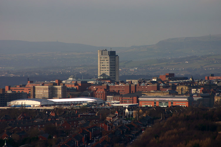


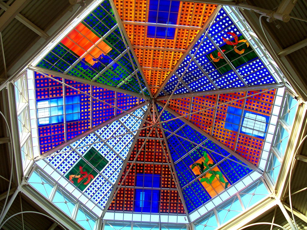


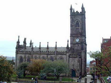


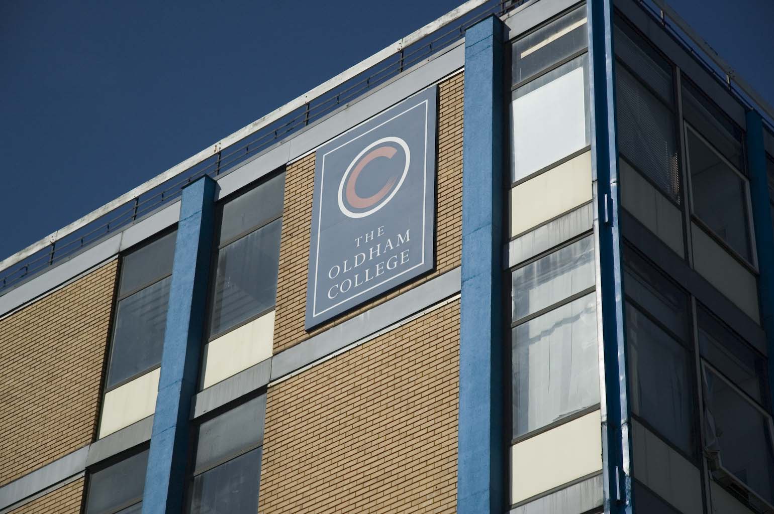


Wikimedia Foundation. 2010.