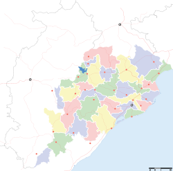
- Nuapada district
-
This article is about the district. For its eponymous headquarters, see Nuapada.
Nuapada — district — Coordinates 20°39′00″N 82°49′59″E / 20.65°N 82.833°ECoordinates: 20°39′00″N 82°49′59″E / 20.65°N 82.833°E Country India State Orissa Headquarters Nuapada Collector Shri Pradeep Kumar Hota Member of Parliament Mr. Bhakta Charan Das Parliamentary constituency Kalahandi Assembly constituency 2, 71.Nuapada, 72.Khariar Population
• Density
530,690 (2001[update])
• 138 /km2 (357 /sq mi)
Sex ratio 0.994 ♂/♀ Official languages Oriya, Hindi, English Time zone IST (UTC+05:30) Area 3,408 square kilometres (1,316 sq mi) Climate
Aw (Köppen)
• 1,230 mm (48 in)
Codes-
• Pincode • 766 xxx • Vehicle • OR-26
Website nuapada.nic.in Nuapada is a district of Orissa, India.
Contents
History
The District of Nuapada was a part of Kalahandi District till early March 1993, but for the administrative convenience, Kalahandi District was divided into two parts i.e. Kalahandi and Nuapada vide State Government Notification No. DRC-44/93/14218/R. dated 27 March 1993. Nuapada District now comprises two sub-division (Nuapada and khariar), two tehsils (Nuapada and Khariar) and five Community Development Blocks (Khariar, Sinapalli, Boden, Nuapada and Komna).
Geography
Naupada district located in western part of Orissa, lies between 20° 0' N and 21° 5' No latitudes and between 82° 20' E and 82° 40' E longitudes. Its boundaries extend in the north, west and south to Mahasamund district in Chhattisgarh and in the east to Bargarh, Balangir and Kalahandi districts. This district is spread over in an area of 3407.5 km² and the administrative headquarters is located at Nuapada.
The plains of Naupada subdivision fringed by rugged hill ranges stretch southward, which belong to the main line of the Eastern Ghats and contain extensive plateaus of about 4000 ft (1200 m) in elevation with long tropical grass grown over them. They contain such mineral deposits of laterite, graphite and bauxite.
Economy
In 2006 the Ministry of Panchayati Raj named Nuapada one of the country's 250 most backward districts (out of a total of 640).[1] It is one of the 19 districts in Orissa currently receiving funds from the Backward Regions Grant Fund Programme (BRGF).[1]
Demographics
According to the 2011 census Nuapada district has a population of 606,490,[2] roughly equal to the nation of Solomon Islands[3] or the US state of Wyoming.[4] This gives it a ranking of 524th in India (out of a total of 640).[2] The district has a population density of 157 inhabitants per square kilometre (410 /sq mi) .[2] Its population growth rate over the decade 2001-2011 was 14.28 %.[2] Nuapada has a sex ratio of 1020 females for every 1000 males,[2] and a literacy rate of 58.2 %.[2]
Flora and fauna
The hill sides rising up precipitously from the plains are covered with dense sal forests. The forests of the district are managed under Forest Division namely Khariar Division. According to their composition, the forests can be classified into sal forests, teak forests, miscellaneous forests where sal, teak and other species occur in mixture and bamboo forest. All these are situated in the dry deciduous forest zone. Timber is by far the major forest produce and sal is no doubt, a major constituent of these products. Other important species are bija, asan, bandhan and teak. Among the minor forest produces of this region are kendu leaf, bamboo, broom-grass, mohua flower and seed, antia bark and sabai-grass. Timber, bamboo and kendu leaf are the main exports outside the state.
See also
- Cultural Profile of South Kosal
- Kosalananda Kavya
- Kosal
- Kosaleswara Temple
- Kosal state movement
References
- ^ a b Ministry of Panchayati Raj (September 8, 2009). "A Note on the Backward Regions Grant Fund Programme". National Institute of Rural Development. http://www.nird.org.in/brgf/doc/brgf_BackgroundNote.pdf. Retrieved September 27, 2011.
- ^ a b c d e f "District Census 2011". Census2011.co.in. 2011. http://www.census2011.co.in/district.php. Retrieved 2011-09-30.
- ^ US Directorate of Intelligence. "Country Comparison:Population". https://www.cia.gov/library/publications/the-world-factbook/rankorder/2119rank.html. Retrieved 2011-10-01. "Solomon Islands 571,890 July 2011 est."
- ^ "2010 Resident Population Data". U. S. Census Bureau. http://2010.census.gov/2010census/data/apportionment-pop-text.php. Retrieved 2011-09-30. "Wyoming 563,626"
External links

Mahasamund district, Chhattisgarh Bargarh district 
Raipur district, Chhattisgarh 
Balangir district  Nuapada district

Kalahandi district State of Orissa · 
Capital 
Topics Districts Angul · Balasore · Bargarh · Bhadrak · Balangir · Boudh · Cuttack · Debagarh · Dhenkanal · Gajapati · Ganjam · Jagatsinghpur · Jajpur · Jharsuguda · Kalahandi · Kandhamal · Kendrapara · Kendujhar · Khordha · Koraput · Malkangiri · Mayurbhanj · Nabarangpur · Nayagarh · Nuapada · Puri · Rayagada · Sambalpur · Subarnapur · Sundargarh
Cities Cities and towns in Nuapada district Nuapada Cities and towns
in other districtsAngul · Balangir · Balasore · Bargarh · Bhadrak · Boudh · Cuttack · Debagarh · Dhenkanal · Gajapati · Ganjam · Jagatsinghpur · Jajpur · Jharsuguda · Kalahandi · Kandhamal · Kendrapara · Kendujhar · Khordha · Koraput · Malkangiri · Mayurbhanj · Nabarangpur · Nayagarh · Puri · Rayagada · Sambalpur · Subarnapur · Sundergarh
Districts of Orissa Angul · Balangir · Balasore · Bargarh · Bhadrak · Boudh · Cuttack · Debagarh · Dhenkanal · Gajapati · Ganjam · Jagatsinghpur · Jajpur · Jharsuguda · Kalahandi · Kandhamal · Kendrapara · Kendujhar · Khordha · Koraput · Malkangiri · Mayurbhanj · Nabarangpur · Nayagarh · Nuapada · Puri · Rayagada · Sambalpur · Subarnapur · SundergarhCategories: -
Wikimedia Foundation. 2010.


