- Milborne Port
-
For the rotten borough, see Milborne Port (UK Parliament constituency).
Coordinates: 50°58′00″N 2°27′40″W / 50.9666°N 2.4610°W
Milborne Port 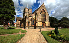
Church of St John the Evangelist
 Milborne Port
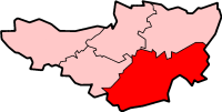
Milborne Port shown within SomersetPopulation 2,735 [1] OS grid reference ST677186 District South Somerset Shire county Somerset Region South West Country England Sovereign state United Kingdom Postcode district DT9 Dialling code 019 Police Avon and Somerset Fire Devon and Somerset Ambulance South Western EU Parliament South West England UK Parliament Somerton and Frome List of places: UK • England • Somerset Milborne Port is a village and civil parish in Somerset, England, east of Sherborne, and in the South Somerset district. It has a population of 2,735.[1] The parish includes the hamlets of Milborne Wick, Kingsbury Regis and Stowell.
The village is surrounded by green fields and countryside on the banks of the River Gascoigne (also known as the River Ivel or River Yeo).
The village has a primary school, which occupies the site of the former infant school. The junior school was closed and all pupils and staff moved to the infant site. In 2006 a new three-classroom extension was opened.
Contents
History
The nearby Laycock Railway Cutting is the best single exposure of the Bathonian ’Fuller's Earth Rock’ in South Somerset.[2] Ammonites indicating the Morrisi and Subcontractus zones of the Middle Bathonian are frequent.[2] Miller's Hill is a geological Site of Special Scientific Interest which is an important and historically famous locality for studies of Middle Jurassic (Bajocian) stratigraphy and palaeontology.[3]
Prehistoric features and finds have been located on the Iron Age hill fort on Barrow Hill, in the north of the parish.[4]
In the Saxon period Milborne Port was important as a mint town, between 997 and 1035.[5] It is one of at least nineteen mint towns which were neither an Alfredian borough nor an eleventh-century shire town, but a minster site.
The parish was part of the hundred of Horethorne.[6]
In 1805, the town was described as follows:
- "MILBORN PORT, (Som.) bor. dist. from London 113 m. 7 f. [furlongs] situated on a branch of the river Parret, and may be considered as divided into three parts, viz. Milborn Port, Kingsbury Regis, and Milborn Wyke; however, the borough and Kingsbury lie in many places promiscuously intermixed together, both in the main town, and at Milborn Wyke; Milborn Wyke being as a village 1 m. N.... In Kingsbury is an annual court-baron held, wherein lord's rents are paid, presentments are made, and a constable, tythingman, and hayward, are appointed, for the year ensuing... Number of actual voters, 9, nominally 114. The church has a square tower, 6 bells, a clock, and chimes; one dissenting meeting-house, and upwards of 1000 inhabitants. The manufactures are dowlas, tick, white baize, linsey, stockings, and shoes. No market, but is supposed to have had one formerly. Fairs, 5 June, and 23 Oct., for cattle and toys. The post is despatched to Sherborne every day at 1 o'clock, and one arrives from thence at the same hour. Near it, on the left, is the seat of William Coles Medlecot, esq."[7]
Under the Reform Act 1832, the town lost its status as a Parliamentary constituency, due to the gerrymandering activities of both parties in preceding elections.
The village was a thriving glove and leather manufacturing area with the last factory closing in 1970.[5]
Ven House with its orangery, entrance gateway, pavilions, terrace, stabling & other outbuildings was built in 1730 by Richard Grange and Decimus Burton. It is a grade I listed building.[8][9][10][11][12][13][14][15]
Governance
The parish council has responsibility for local issues, including setting an annual precept (local rate) to cover the council’s operating costs and producing annual accounts for public scrutiny. The parish council evaluates local planning applications and works with the local police, district council officers, and neighbourhood watch groups on matters of crime, security, and traffic. The parish council's role also includes initiating projects for the maintenance and repair of parish facilities, as well as consulting with the district council on the maintenance, repair, and improvement of highways, drainage, footpaths, public transport, and street cleaning. Conservation matters (including trees and listed buildings) and environmental issues are also the responsibility of the council.
The village falls within the Non-metropolitan district of South Somerset, which was formed on 1 April 1974 under the Local Government Act 1972, having previously been part of Wincanton Rural District.[16] The district council is responsible for local planning and building control, local roads, council housing, environmental health, markets and fairs, refuse collection and recycling, cemeteries and crematoria, leisure services, parks, and tourism.
Somerset County Council is responsible for running the largest and most expensive local services such as education, social services, libraries, main roads, public transport, policing and fire services, trading standards, waste disposal and strategic planning.
It is also part of the Somerton and Frome county constituency represented in the House of Commons of the Parliament of the United Kingdom. It elects one Member of Parliament (MP) by the first past the post system of election, and part of the South West England constituency of the European Parliament which elects seven MEPs using the d'Hondt method of party-list proportional representation.
Church
The cruciform church of Church of St John the Evangelist is of late Anglo-Saxon date and parts may well span the Norman conquest. The chancellor Regimbald (a survivor from Edward’s reign into William’s) rebuilt his Minster at Milborne Port in “a sumptuous hybrid style.” It would seem logical to assign the now-demolished nave to this period, since the surviving south doorway of the nave was incorporated into the 1860s rebuild and is perhaps of Saxo-Norman design.[17]
However, despite the Victorian nave (almost totally rebuilt 1867–69) and accompanying north aisle, there remains the pre-conquest central tower, part transepts and chancel. The south transept was heavily restored in 1843. The north transept was rebuilt along with the nave, so compared to pre-1867 almost half of the Anglo-Saxon church has now gone.
The new nave is 28 feet (9 m) longer than the original it replaced. The old west front exhibited vestiges of triangular-headed arcading on either side of the inserted Perpendicular west window, and the lower part of the front was divided into compartments, by broad pilasters of plain square section. This was recorded by photography and the photo was published in 1893 by A. Reynolds, who was involved with building the new nave.
The crossing (tower) is wider in plan than the nave, and markedly wider than the transepts or chancel. This is a distinctive Saxon trait, which may also be observed at nearby Sherborne Abbey (where significant traces of the Saxon rubble west wall may be seen, and which include a Saxon doorway in the north aisle). Inside, the four crossing arches with their jambs survive, although the east and west arches have been rebuilt in pointed 14th-century form; the south and north arches have been slightly deformed to elliptical shape due to the pressure of the masonry, perhaps by the addition of the top stage of the tower in Norman times.
The chancel exhibits pilaster strip work, much disturbed and cut by Early English period windows, and has a close parallel at Bradford-on-Avon. The wall thickness of the chancel is 2 ft 8 in (0.81 m), which is a typical Anglo-Saxon dimension. The church, with its Anglo-Saxon features, is of major importance to our understanding of the larger minsters in pre-conquest England.[18]
The church has been designated by English Heritage as a Grade I listed building.[19]
See also
- Regis (Place)
- List of place names with royal patronage in the United Kingdom
References
- ^ a b "South Somerset population estimates for 2002". Somerset County Council. http://www.webcitation.org/5lRyCVNCk. Retrieved 27 December 2009.
- ^ a b English Nature citation sheet for Laycock Railway Cutting (accessed 10 August 2006)
- ^ English Nature citation sheet for Miller's Hill, Milborne Wick (accessed 10 August 2006)
- ^ Richardson, Miranda. "Milborne Port". Somerset Urban Archaeological Survey. Somerset County Council. http://www1.somerset.gov.uk/archives/hes/downloads/EUS_MilbornePortText.pdf. Retrieved 2 February 2010.
- ^ a b "Milborne Port". A History of the County of Somerset: Volume 7. British History Online. http://www.british-history.ac.uk/report.aspx?compid=18746. Retrieved 17 August 2008.
- ^ "Somerset Hundreds". GENUKI. http://www.genuki.org.uk/big/eng/SOM/Miscellaneous/. Retrieved 9 October 2011.
- ^ Oulton, W. C. (1805) The Traveller's Guide; or, English Itinerary, Vol II, pp 272-273. Ivy-Lane, London: James Cundee.
- ^ "Ven House, Milborne Port". Images of England. English Heritage. http://www.imagesofengland.org.uk/Details/Default.aspx?id=261884. Retrieved 19 January 2009.
- ^ "Corridor linking Ven House and the Orangery, Milborne Port". Images of England. English Heritage. http://www.imagesofengland.org.uk/Details/Default.aspx?id=261887. Retrieved 19 January 2009.
- ^ "Main entrance gateway, 35 metres North-West of Ven House, Milborne Port". Images of England. English Heritage. http://www.imagesofengland.org.uk/Details/Default.aspx?id=261890. Retrieved 19 January 2009.
- ^ "North-East Pavilion and balustraded brick wall, Ven House, Milborne Port". Images of England. English Heritage. http://www.imagesofengland.org.uk/Details/Default.aspx?id=261885. Retrieved 19 January 2009.
- ^ "North-West Pavilion and balustraded link wall, Ven House, Milborne Port". Images of England. English Heritage. http://www.imagesofengland.org.uk/Details/Default.aspx?id=261886. Retrieved 19 January 2009.
- ^ "Stabling and other outbuildings, attached to East side of Ven House, Milborne Port". Images of England. English Heritage. http://www.imagesofengland.org.uk/Details/Default.aspx?id=261889. Retrieved 19 January 2009.
- ^ "Terrace along South Garden front, Ven House, Milborne Port". Images of England. English Heritage. http://www.imagesofengland.org.uk/Details/Default.aspx?id=261891. Retrieved 19 January 2009.
- ^ "The Orangery, attached to the South West corner of Ven House, Milborne Port". Images of England. English Heritage. http://www.imagesofengland.org.uk/Details/Default.aspx?id=261888. Retrieved 19 January 2009.
- ^ A Vision of Britain Through Time : Wincanton Rural District
- ^ Blair, John (2005). The Church in Anglo-Saxon Society. Oxford University Press. ISBN 9780198226956.
- ^ Taylor, H.M.; Joan Taylor (1965). Anglo-Saxon Architecture. 1.
- ^ "Church of St John the Evangelist". Images of England. English Heritage. http://www.imagesofengland.org.uk/Details/Default.aspx?id=261841. Retrieved 17 August 2008.
External links
- Milborne Port community website
- Milborne Port Opera
- Vallins, John. "Rolling down the river", The Guardian, 5 July 2005
Categories:- Villages in South Somerset
- Civil parishes in Somerset


Wikimedia Foundation. 2010.