- Burwood Council
-
Burwood Council
New South Wales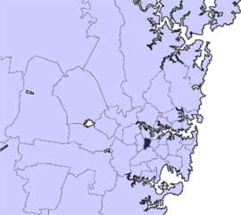
Population: 33,803(2009)[1] • Density: 4829/km² (12,507.1/sq mi) Area: 7 km² (2.7 sq mi) Mayor: John Faker Council Seat: Burwood Region: Metropolitan Sydney State District: Strathfield, Canterbury Federal Division: Reid, Watson LGAs around Burwood Council: Canada Bay Strathfield Burwood Council Ashfield Canterbury The Municipality of Burwood is a Local Government Area in the inner-west of Sydney, in the state of New South Wales, Australia.
Contents
Suburbs in the local government area
Suburbs serviced by Burwood Council are:
It also includes portions of:
- Croydon (shared with Ashfield Council)
- Croydon Park (shared with the City of Canterbury and Ashfield Council)
- Strathfield (shared with the City of Canada Bay and Strathfield Council)
Council
Burwood Council is composed of seven councillors elected proportionally. The mayor is not directly elected.[2] The current makeup of the council is as follows:[2]
Party Councillors Australian Labor Party 3 Liberal Party of Australia 2 Burwood Community Voice 1 The Greens 1 Total 7 The current council, elected in 2010, is:[2][3]
Councillor Party Notes John Faker Labor Mayor since 2011 John Sidoti Liberal Mayor between 2009 - 2011; when he stood down following the 2011 state election[4] Lesley Furneaux-Cook Community Voice Ernest Wong Labor Deputy Mayor Sally Deans Labor Henson Liang Liberal Christine Donayre Greens References
- ^ Australian Bureau of Statistics (30 March 2011). "Regional Population Growth, Australia, 2009–10". http://www.abs.gov.au/AUSSTATS/abs@.nsf/DetailsPage/3218.02009-10. Retrieved 28 October 2011.
- ^ a b c "Burwood Council". 2008 Election results. Electoral Commission NSW. http://www.lg.elections.nsw.gov.au/LGE2008/result.Burwood.html. Retrieved 2009-06-16.[dead link]
- ^ "Mayor and Councillors". Burwood Council. http://www.burwood.nsw.gov.au/mayor_and_councillors.html. Retrieved 8 June 2010.
- ^ Saulwick, Jacob (29 March 2011). "Grazie, signore - ALP dumped in Drummoyne". The Sydney Morning Herald (Fairfax Media). http://www.smh.com.au/nsw/state-election-2011/grazie-signore--alp-dumped-in-drummoyne-20110328-1cdiq.html. Retrieved 9 April 2011.
External links
Regions of Sydney Local Government Areas of SydneyAshfield · Auburn · Bankstown · Blacktown · Botany Bay · Burwood · Camden · Campbelltown · Canada Bay · Canterbury · Fairfield · The Hills · Holroyd · Hornsby · Hunter's Hill · Hurstville · Kogarah · Ku-ring-gai · Lane Cove · Leichhardt · Liverpool · Manly · Marrickville · Mosman · North Sydney · Parramatta · Penrith · Pittwater · Randwick · Rockdale · Ryde · Strathfield · Sutherland · City of Sydney · Warringah · Waverley · Willoughby · WoollahraLocal Government Areas of New South Wales Metropolitan Sydney Inner SydneyAshfield · Botany Bay · Burwood · Canada Bay · Canterbury · Hurstville · Kogarah · Lane Cove · Leichhardt · Manly · Marrickville · Mosman · North Sydney · Randwick · Rockdale · Strathfield · Sydney · Waverley · Willoughby · WoollahraOuter SydneyAuburn · Bankstown · Blacktown · Camden · Campbelltown · Fairfield · The Hills · Holroyd · Hornsby · Hunter's Hill · Ku-ring-gai · Liverpool · Parramatta · Penrith · Pittwater · Ryde · Sutherland · WarringahSydney SurroundsMid North Coast Bellingen · Clarence Valley · Coffs Harbour · Greater Taree · Kempsey · Nambucca · Port Macquarie-Hastings · Lord Howe IslandMurray Murrumbidgee Carrathool · Coolamon · Cootamundra · Griffith · Gundagai · Hay · Junee · Leeton · Lockhart · Murrumbidgee · Narrandera · Temora · Wagga WaggaHunter Cessnock · Dungog · Gloucester · Great Lakes · Lake Macquarie · Maitland · Muswellbrook · Newcastle · Port Stephens · Singleton · Upper HunterIllawarra Richmond Tweed Southeastern Bega · Bombala · Boorowa · Cooma-Monaro · Eurobodalla · Goulburn Mulwaree · Harden · Palerang · Queanbeyan · Snowy River · Tumut · Upper Lachlan · Yass Valley · YoungNorthern Armadale Dumaresq · Glen Innes-Severn · Gunnedah · Guyra · Gwydir · Inverell · Liverpool Plains · Moree Plains · Narrabri · Tamworth · Tenterfield · Uralla · WalchaCentral West North Western Far West Categories:- Australia government stubs
- Local Government Areas in Sydney

Wikimedia Foundation. 2010.