- City of Randwick
-
City of Randwick
New South Wales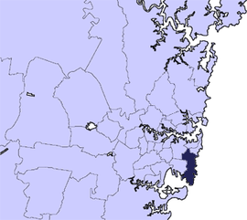
Population: 131,714(2009)[1] • Density: 3500/km² (9,065.0/sq mi) Area: 36 km² (13.9 sq mi) Mayor: Scott Nash Council Seat: Randwick Region: Metropolitan Sydney State District: Coogee, Maroubra, Heffron Federal Division: Kingsford Smith, Wentworth LGAs around City of Randwick: City of Sydney Waverley Municipal Council Waverley Municipal Council City of Botany Bay City of Randwick Pacific Ocean Sutherland Shire Sutherland Shire Pacific Ocean The City of Randwick [2] is a Local Government Area in the Eastern Suburbs of Sydney, in the state of New South Wales, Australia. One of Sydney's largest parks, Centennial Park, lies within the city boundary of Randwick. Other major landmarks in Randwick include the world-famous Randwick Racecourse, the University of New South Wales and Coogee and Maroubra Beaches. There is some industry in the south, centered around the container terminals of Port Botany in Botany Bay, which lie partially within the city. Randwick has several golf clubs, including the exclusive Australian Golf Club and New South Wales Golf Club.
Major commercial centres within Randwick City include the suburb of Randwick, home to the municipal council; Kingsford, which has a large Chinese and Indonesian community, as well as a large student population; Maroubra Junction; and Matraville. The Australian Army has a major presence in Randwick, with the headquarters of the 2nd Division being located in Randwick Barracks, Avoca Street, Randwick. There is a large state prison at Long Bay (Long Bay Correctional Centre). The Prince of Wales Hospitals, adjacent to the University of New South Wales, is one of Sydney's major hospital complexes. The Botany Bay National Park lies partially within the City of Randwick and is notable for preserving some of the last remaining stands of pre-European coastal heath vegetation in the Sydney area, known as Endangered Eastern Suburbs Banksia Scrub. There is a historic fort on Bare Island at the mouth of Botany Bay, in the suburb of La Perouse. This fort, and another Randwick attraction, the racecourse, featured prominently in the 2000 movie Mission: Impossible II. La Perouse is also home to one of Sydney's largest Aboriginal communities.
Contents
History
Indigenous Australian history in the area dates back tens of thousands of years. The local people at the time of colonisation were the Cadigal of the Dharug language group. European settlement led to the deaths of many Cadigal via introduced diseases or in conflict with settlers. The surviving Cadigal left the area or were pushed to the fringes of settlement. By the mid-nineteenth century, the original tribal groupings had been effectively destroyed.
The name Randwick comes from the village of Randwick in Gloucestershire, England, birthplace of the district's first mayor Simeon Henry Pearce. The area was home to a few wealthy landowners and the poor residents of several shantytowns until the 1880s, when the coming of trams from Sydney brought extensive suburban development. This development continued steadily, with new tram lines (long since demolished) opening up most of the city for subdivision by the early 1900s.
The New South Wales University of Technology opened at Kensington in 1949 on the site of Kensington Racecourse, eventually becoming the University of New South Wales. The university is now one of Randwick City's major landmarks.
The City of Randwick now has a significant Indigenous Australian population, mostly concentrated in the southern half of the city.
Demographics
According to the Australian Bureau Statistics [3], there:
- were 127,948 people as at 30 June 2006, the 19th largest Local Government Area in New South Wales. It was equal to 1.9% of the New South Wales population of 6,827,694
- was an increase of 1,012 people over the year to 30 June 2006, the 16th largest population growth in a Local Government Area in New South Wales. It was equal to 1.7% of the 58,753 increase in the population of New South Wales
- was, in percentage terms, an increase of 0.8% in the number of people over the year to 30 June 2006, the 68th fastest growth in population of a Local Government Area in New South Wales. In New South Wales the population grew by 0.9%
- was an increase in population over the 10 years to 30 June 2006 of 4,482 people or 3.6% (0.4% in annual average terms), the 80th highest rate of a Local Government Area in New South Wales. In New South Wales the population grew by 622,966 or 10% (1.0% in annual average terms) over the same period.
Suburbs in the local government area
Suburbs and localities in the City of Randwick are:
- Centennial Park
- Chifley
- Clovelly
- Coogee
- Hillsdale
- Kensington
- Kingsford
- La Perouse
- Little Bay
- Malabar
- Maroubra
- Maroubra Junction
- Matraville
- Phillip Bay
- Port Botany
- Randwick
- South Coogee
- University of New South Wales
Council
Randwick City Council is composed of fifteen councillors elected proportionally. The area is divided into five wards, each electing three councillors. The mayor is not directly elected.[4] The current makeup of the council is as follows:[4]
Party Councillors Liberal Party of Australia 5 Australian Labor Party 4 The Greens 3 No Parking Meters Party 1 Independent 2 Total 15 The current council, elected in 2008, is:[4]
Ward Councillor Party Notes Central Ward Ted Seng Liberal Anthony Andrews Independent Geoff Stevenson Labor East Ward Bruce Notley-Smith Liberal Murray Matson Greens Tony Bowen Labor North Ward Kiel Smith Liberal Margaret Woodsmith Greens Paul Tracey Labor South Ward Alan White Labor Charles Matthews No Parking Meters Robert Belleli Liberal West Ward Scott Nash Liberal Mayor John Procopiadis Independent Bradley Hughes Greens Deputy Mayor References
- ^ Australian Bureau of Statistics (30 March 2010). "Regional Population Growth, Australia, 2008–09". http://www.abs.gov.au/ausstats/abs@.nsf/Latestproducts/3218.0Main%20Features42008-09?opendocument&tabname=Summary&prodno=3218.0&issue=2008-09&num=&view=. Retrieved 3 June 2010.
- ^ http://www.randwick.nsw.gov.au/library/scripts/objectifyMedia.aspx?file=pdf/8/60.pdf&siteID=1&str_title=Randwick City Council Wards and Suburbs.pdf
- ^ "Regional Population Growth, Australia, 2005-06 (catalogue no.: 3218.0)". Australian Bureau of Statistics. http://abs.gov.au. Retrieved 2007-03-12.
- ^ a b c "Randwick City Council". 2008 Election results. Electoral Commission NSW. http://www.pastvtr.elections.nsw.gov.au/LGE2008/result.Randwick.html. Retrieved 2011-07-11.
External links
Regions of Sydney Local Government Areas of Sydney Ashfield · Auburn · Bankstown · Blacktown · Botany Bay · Burwood · Camden · Campbelltown · Canada Bay · Canterbury · Fairfield · The Hills · Holroyd · Hornsby · Hunter's Hill · Hurstville · Kogarah · Ku-ring-gai · Lane Cove · Leichhardt · Liverpool · Manly · Marrickville · Mosman · North Sydney · Parramatta · Penrith · Pittwater · Randwick · Rockdale · Ryde · Strathfield · Sutherland · City of Sydney · Warringah · Waverley · Willoughby · WoollahraList of Sydney suburbs Local Government Areas of New South Wales Metropolitan Sydney Inner SydneyAshfield · Botany Bay · Burwood · Canada Bay · Canterbury · Hurstville · Kogarah · Lane Cove · Leichhardt · Manly · Marrickville · Mosman · North Sydney · Randwick · Rockdale · Strathfield · Sydney · Waverley · Willoughby · WoollahraOuter SydneyAuburn · Bankstown · Blacktown · Camden · Campbelltown · Fairfield · The Hills · Holroyd · Hornsby · Hunter's Hill · Ku-ring-gai · Liverpool · Parramatta · Penrith · Pittwater · Ryde · Sutherland · WarringahSydney SurroundsMid North Coast Bellingen · Clarence Valley · Coffs Harbour · Greater Taree · Kempsey · Nambucca · Port Macquarie-Hastings · Lord Howe IslandMurray Murrumbidgee Carrathool · Coolamon · Cootamundra · Griffith · Gundagai · Hay · Junee · Leeton · Lockhart · Murrumbidgee · Narrandera · Temora · Wagga WaggaHunter Cessnock · Dungog · Gloucester · Great Lakes · Lake Macquarie · Maitland · Muswellbrook · Newcastle · Port Stephens · Singleton · Upper HunterIllawarra Richmond Tweed Southeastern Bega · Bombala · Boorowa · Cooma-Monaro · Eurobodalla · Goulburn Mulwaree · Harden · Palerang · Queanbeyan · Snowy River · Tumut · Upper Lachlan · Yass Valley · YoungNorthern Armadale Dumaresq · Glen Innes-Severn · Gunnedah · Guyra · Gwydir · Inverell · Liverpool Plains · Moree Plains · Narrabri · Tamworth · Tenterfield · Uralla · WalchaCentral West North Western Far West Categories:- Local Government Areas in Sydney
- Botany Bay

Wikimedia Foundation. 2010.