- Black Fork (Cheat River)
Geobox|River
name = Black Fork
native_name =
other_name =
other_name1 =

image_size = 300
image_caption = The Black Fork atHendricks, West Virginia looking upstream. The confluence of the Blackwater River (left) and the Dry Fork (right) is visible.
country = United States
country_
state = West Virginia
state_
region_type = County
region = Tucker
length_imperial = 4
length_note ="The American Rivers Outstanding Rivers List", Second Edition, May 1991. Compiled and edited by Matthew H. Huntington and John D. Echeverria. Washington, DC: American Rivers, Inc.]
watershed_imperial = 500
watershed_note =West Virginia Department of Environmental Protection. [http://www.dep.state.wv.us/watershed/ Watershed Atlas Project] : [http://www.dep.state.wv.us/watershed/w5020004.html Cheat River watershed] . Sum of watershed areas of Dry Fork, Blackwater River, Glady Fork, Laurel Fork, Gandy Creek, and Red Creek. Retrieved onDecember 11 ,2006 .]
discharge_location =
discharge_imperial =
discharge_max_imperial =
discharge_min_imperial =
discharge1_location =
discharge1_imperial =
source_name = Dry Fork
source_location = Col between Harper and Yokum knobs
source_district =
source_region = Randolph County
source_state = West Virginia
source_country =
source_lat_d = 38
source_lat_m = 44
source_lat_s = 01
source_lat_NS = N
source_long_d = 79
source_long_m = 38
source_long_s = 52
source_long_EW = W
source_elevation_imperial = 3740
source_length_imperial =
source1_name = Blackwater River
source1_location =Canaan Valley
source1_district =
source1_region = Tucker County
source1_state = West Virginia
source1_country =
source1_lat_d = 39
source1_lat_m = 03
source1_lat_s = 32
source1_lat_NS = N
source1_long_d = 79
source1_long_m = 29
source1_long_s = 04
source1_long_EW = W
source1_elevation_imperial = 3540
source1_length_imperial = 31
source1_length_note =Hissom, Patricia. 2006. "Blackwater River." The West Virginia Encyclopedia. Ken Sullivan, editor. Charleston, WV: West Virginia Humanities Council. ISBN 0-9778498-0-5.]
source_confluence_location = Hendricks
source_confluence_district =
source_confluence_region =
source_confluence_state = West Virginia
source_confluence_country =
source_confluence_lat_d = 39
source_confluence_lat_m = 04
source_confluence_lat_s = 20
source_confluence_lat_NS = N
source_confluence_long_d = 79
source_confluence_long_m = 37
source_confluence_long_s = 45
source_confluence_long_EW = W
source_confluence_elevation_imperial = 1700
source_confluence_coordinates_note =Gnis|1550368|Black Fork]
mouth_name =Cheat River
mouth_location = Parsons
mouth_district =
mouth_region =
mouth_state = West Virginia
mouth_country =
mouth_lat_d = 39
mouth_lat_m = 06
mouth_lat_s = 39
mouth_lat_NS = N
mouth_long_d = 79
mouth_long_m = 40
mouth_long_s = 44
mouth_long_EW = W
mouth_elevation_imperial = 1621
free_name =
free_value =
map_size = 300
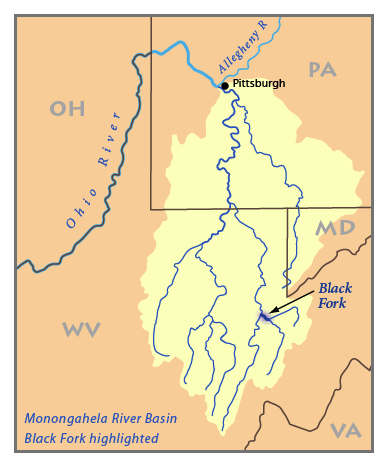
map_caption = Map of the Monongahela River basin, with Black Fork highlighted. The Black Fork is a principaltributary of theCheat River in easternWest Virginia in theUnited States . It is a short stream, about fourmile s (6 km) in length,"The American Rivers Outstanding Rivers List", Second Edition, May 1991. Compiled and edited by Matthew H. Huntington and John D. Echeverria. Washington, DC: American Rivers, Inc.] formed by the confluence of two other streams not far above its mouth.DeLorme (1997). "West Virginia Atlas & Gazetteer". Yarmouth, Maine: DeLorme. ISBN 0-89933-246-3.]Geography
Via the Cheat, Monongahela and Ohio Rivers, it is part of the watershed of the
Mississippi River , draining an area of 500square mile s (1,295 km²). The Black Fork flows for its entire length in Tucker County. It is formed at the town of Hendricks by the confluence of the Dry Fork and the Blackwater River, and flows generally northwestwardly through Hambleton to Parsons, where it joins the Shavers Fork to form the Cheat River.Name
The
U.S. Board on Geographic Names settled on "Black Fork" as the stream's name in 1930. According to theGeographic Names Information System , it has also been known historically as "Blackwater Fork" and as the Blackwater River.ee also
*
List of West Virginia rivers
*Blackwater Canyon References
*Julian, Norman. 2006. "Cheat River." "The West Virginia Encyclopedia". Ken Sullivan, editor. Charleston, WV: West Virginia Humanities Council. ISBN 0-9778498-0-5.

Wikimedia Foundation. 2010.