- Mays Hill, New South Wales
-
Mays Hill
Sydney, New South Wales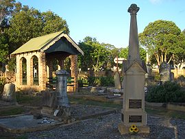
Mays Hill Historic CemeteryPostcode: 2145 Location: 24 km (15 mi) west of Sydney CBD LGA: City of Holroyd State District: Parramatta Federal Division: Parramatta Suburbs around Mays Hill: Wentworthville Westmead Parramatta Wentworthville Mays Hill Parramatta South Wentworthville Merrylands West Merrylands Mays Hill is a suburb of Sydney, in the state of New South Wales, Australia. Mays Hill is located 24 kilometres west of the Sydney central business district, in the local government area of the City of Holroyd and is part of the Greater Western Sydney region.
Mays Hill has a stop on the T-80 T-Way bus service. It is also serviced by several Westbus bus routes.
History
Originally some of the land that is now Mays Hill was part of the governor's domain. This was subdivided and Thomas May was one of the purchesers.
Mays Hill Cemetery
Mays Hill Cemetery is the only cemetery in Holroyd local government area and contains the graves of many well known local pioneering families including the Paytens, Fullagars, Houisons, Downs, Ardills and Mustons. This cemetery was originally known as Western Road Cemetery as it is located on the Great Western Highway.
External links
Suburbs and localities within the City of Holroyd · Western Sydney · Sydney Fairfield · Girraween · Granville · Greystanes · Guildford · Guildford West · Holroyd · Mays Hill · Merrylands · Merrylands West · Parramatta · Pemulwuy · Pendle Hill · Prospect · South Wentworthville · Smithfield · Wentworthville · Westmead · Woodpark · Yennora
List of Sydney suburbs Coordinates: 33°49′18″S 150°59′32″E / 33.82161°S 150.99222°E
Categories:- Suburbs of Sydney
- Sydney geography stubs

Wikimedia Foundation. 2010.