- Arlington, Massachusetts
-
Arlington, Massachusetts — Town — Ice Harvesting on Spy Pond, from an 1854 Print.

SealNickname(s): A-Town[citation needed] Location in Massachusetts
Coordinates: 42°24′55″N 71°09′25″W / 42.41528°N 71.15694°WCoordinates: 42°24′55″N 71°09′25″W / 42.41528°N 71.15694°W Country United States State Massachusetts County Middlesex Settled 1635 Incorporated 1807 Government – Type Representative town meeting – Town Manager Brian Sullivan – Board of
SelectmenKevin F. Greeley
Annie LaCourt
Diane Mahon
Clarissa Rowe
Dan DunnArea – Total 5.5 sq mi (14.3 km2) – Land 5.2 sq mi (13.4 km2) – Water 0.3 sq mi (0.9 km2) Elevation 46 ft (14 m) Population (2010) – Total 42,844 – Density 8,239.2/sq mi (3,197.3/km2) Time zone Eastern (UTC-5) – Summer (DST) Eastern (UTC-4) ZIP code 02474, 02476 Area code(s) 339 / 781 FIPS code 25-01605 GNIS feature ID 0619393 Website www.arlingtonma.gov Arlington is a town in Middlesex County, Massachusetts, United States, six miles (10 km) northwest of Boston. The population was 42,844 at the 2010 census.
Contents
History
 Patriots' Grave in the Old Burying Ground, Arlington, Massachusetts.
The Town of Arlington was originally settled by European colonists in 1635 as a village within the boundaries of Cambridge, Massachusetts under the name Menotomy, an Algonquian word meaning "swift running water". A larger area, including land that was later to become the town of Belmont, and outwards to the shore of the Mystic River, which had previously been part of Charlestown, was incorporated on February 27, 1807 as West Cambridge. In 1867, the name "Arlington" was chosen in honor of those buried in Arlington National Cemetery; the name change took effect that April 30.
The Massachusett tribe, part of the Algonquian group of Native Americans, lived around the Mystic Lakes, the Mystic River and Alewife Brook. By the time Europeans arrived, the local Indians had been devastated by disease; also, the tribal chief, Nanepashemet, had been killed by a rival tribe in about 1619. Nanepashemet's widow, known to history only as "Squaw Sachem", sold the land of her tribe to the colonists for ten pounds, with provisions that she and her tribe could remain on her homestead land around the Mystic Lakes and continue hunting and farming. She also was to be given a new winter coat of wool each year for the rest of her life. She is thought to have lived until about 1650.
 The Jason Russell House.
Through the town also flows the stream called Mill Brook, which historically figured largely into Arlington's economy. In 1637 Captain George Cooke built the first mill in this area. Subsequently, seven mills were built along the stream, including the Old Schwamb Mill, which survives to this day. The Schwamb Mill has been a working mill since 1650, making it the longest working mill in the country.
Paul Revere's famous midnight ride to alert colonists took him through Menotomy,[1] now known as Arlington. Later on that first day of the American Revolution, more blood was shed in Menotomy than in the battles of Lexington and Concord combined. Minutemen from surrounding towns converged on Menotomy to ambush the British on their retreat from Concord and Lexington. All in all, 25 colonials were killed in Menotomy (half of all Americans killed in the day's battles), as well as 40 British troops (more than half their fatalities).
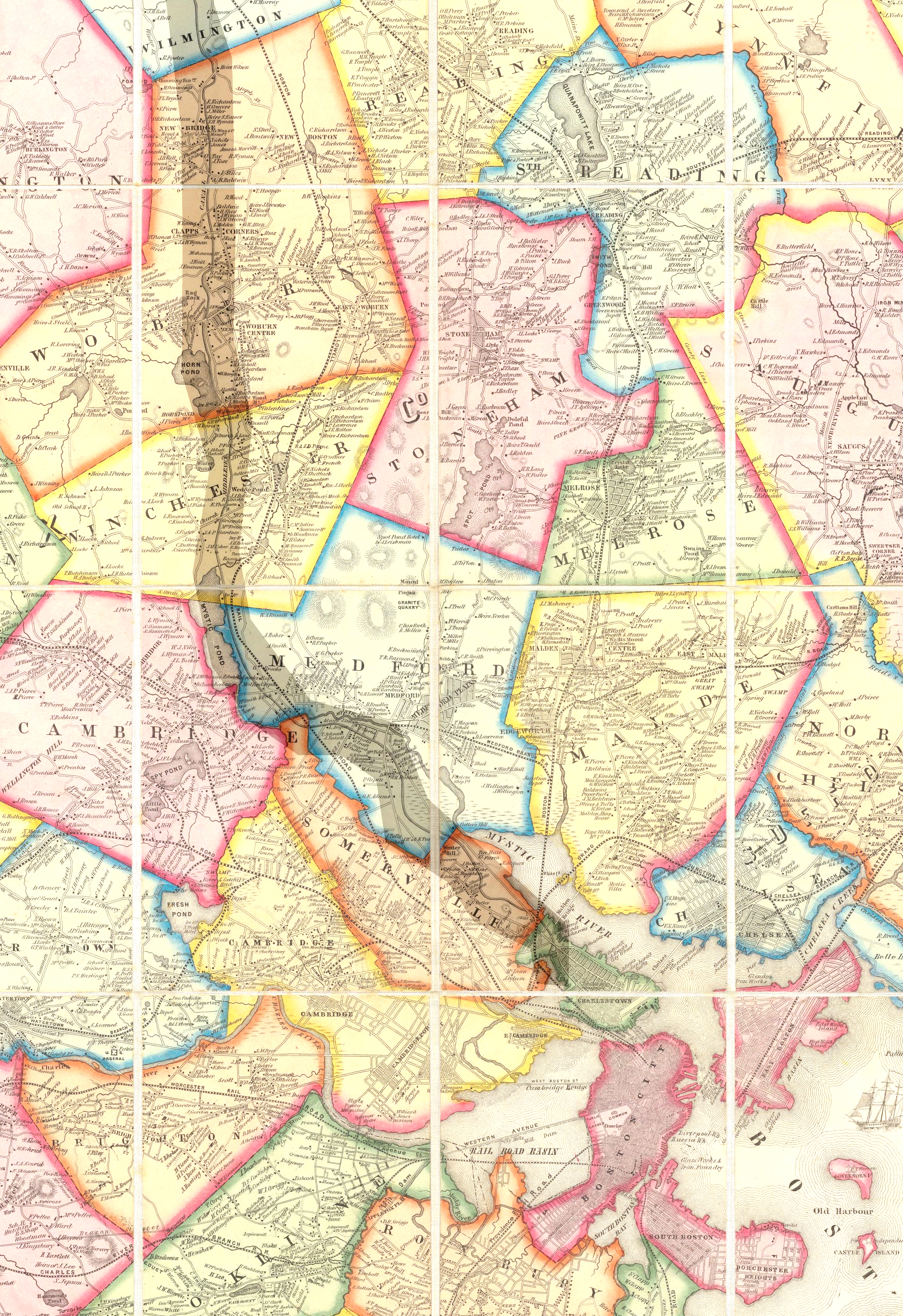
 1852 Map of Boston area showing Arlington, then called West Cambridge. (The former Middlesex Canal is highlighted.)
The Jason Russell House, a yellow colonial, is today a museum which remembers those twelve Americans, including Russell himself, who were killed in and around this pictured dwelling on April 19, 1775. Bullet holes are visible in the interior walls to this day.
In its early years, Arlington was a thriving farming community and had its own lettuce that was quite popular.[2]
Arlington had a large ice industry on Spy Pond from the mid-19th century until the last ice house burned down in 1930; much of its ice was sent to the Caribbean and India by "Ice King" Frederic Tudor.
Arlington's population grew by over 90 percent during the 1920s.[3]
In 1979, the first spreadsheet software program, VisiCalc, was developed by Bob Frankston and Dan Bricklin in the attic of the Arlington apartment rented by Bob Frankston.[4]
Arlington was the site of the accident which claimed the life of American cyclist Nicole Reinhart, a two-time Pan American Games winner. She was killed on September 17, 2000 when she was thrown from her bicycle during a cycling tournament.
 An 1875 map of Arlington
Geography
Arlington covers 3,517.5 acres (14 km2), or 5.5 square miles, of which 286.2 acres (1.2 km2) are covered by water. There are 210.52 acres (0.9 km2) of parkland. Elevation ranges from 4 feet (1.2 m) above sea level (along Alewife Brook) to 377 feet (114.9 m) near Park Avenue and Eastern Avenue.
Arlington borders on the Mystic Lakes, Mystic River, and Alewife Brook. Within its borders are Spy Pond, the Arlington Reservoir, Mill Brook, and Hills Pond.
Adjacent towns
Arlington is located in eastern Massachusetts and is bordered by six towns: Winchester to the north, Medford to the northeast, Somerville to the east, Cambridge to the southeast, Belmont to the south, and Lexington to the west.
Demographics
Historical populations Year Pop. ±% 1870 3,261 — 1880 4,100 +25.7% 1890 5,029 +22.7% 1900 8,603 +71.1% 1910 11,187 +30.0% 1920 18,665 +66.8% 1930 36,094 +93.4% 1940 40,013 +10.9% 1950 44,353 +10.8% 1960 49,953 +12.6% 1970 53,524 +7.1% 1980 48,219 −9.9% 1990 44,630 −7.4% 2000 42,389 −5.0% 2001* 42,343 −0.1% 2002* 42,005 −0.8% 2003* 41,780 −0.5% 2004* 41,495 −0.7% 2005* 41,218 −0.7% 2006* 40,969 −0.6% 2007* 41,072 +0.3% 2008* 41,241 +0.4% 2009* 41,719 +1.2% 2010 42,844 +2.7% * = population estimate. Source: United States Census records and Population Estimates Program data.[5][6][7][8][9][10][11][12] At the 2000 census[13], there were 42,389 people, 19,011 households and 10,779 families residing in the town. The population density was 8,179.6 per square mile (3,159.6/km2). There were 19,411 housing units at an average density of 3,745.6 per square mile (1,446.8/km2). The racial makeup of the town was 90.97% White, 1.70% African American, 0.13% Native American, 4.97% Asian, 0.01% Pacific Islander, 0.66% from other races, and 1.56% from two or more races. Hispanic or Latino of any race were 1.86% of the population.
There were 19,011 households of which 23.1% had children under the age of 18 living with them, 45.4% were married couples living together, 8.8% had a female householder with no husband present, 2.2% were unmarried partners, and 43.3% were non-families. 34.2% of all households were made up of individuals and 12.5% had someone living alone who was 65 years of age or older. The average household size was 2.22 and the average family size was 2.91.
The population distribution showed 18.4% under the age of 18, 5.1% from 18 to 24, 36.0% from 25 to 44, 23.7% from 45 to 64, and 16.8% who were 65 years of age or older. The median age was 40 years. For every 100 females there were 86.7 males. For every 100 females age 18 and over, there were 83.1 males.
The median household income was $64,344, and the median family income was $78,741 (these figures had risen to $77,279 and $98,381 respectively in a 2007 estimate).[14] Males had a median income of $52,352 versus $40,445 for females. The per capita income for the town was $34,399. About 2.4% of families and 4.1% of the population were below the poverty line, including 2.0% of those under age 18 and 5.5% of those age 65 or over.
Arlington's population in 2000 was a decrease of 20.8% from 53,534 in 1970.[15]
Government
 Arlington Town Hall
County government: Middlesex County Clerk of Courts: Michael A. Sullivan District Attorney: Gerard T. Leone, Jr. Register of Deeds: Richard P. Howe, Jr. (North at Lowell)
Eugene C. Brune (South at Cambridge)Register of Probate: Tara E. DeCristofaro County Sheriff: Peter Koutoujian State government State Representative(s): William N. Brownsberger (D)
Sean Garballey (D)
Jay R. Kaufman (D)State Senator(s): Kenneth J. Donnelly (D) Governor's Councilor(s): Terrence Kennedy Federal government U.S. Representative(s): Edward J. Markey (D-7th District) U.S. Senators: John Kerry (D), Scott Brown (R) Arlington's executive branch consists of an elected five-member Board of Selectmen. The day-to-day operations are handled by a Town Manager hired by the Board of Selectmen. The legislative branch is made up of 252 Town Meeting Members, elected from the 21 precincts. The Town of Arlington has enough citizens to become the City of Arlington, but has not done so, in part because it would lose its ability to hold Town Meetings. These meetings can often last for at least a month, being held two nights a week until the issues are settled.
Brian F. Sullivan is the current Town Manager.[16]
The current members of the Board of Selectmen are Kevin F. Greeley (Chair), Diane Mahon (Vice Chair), Annie LaCourt, Daniel J. Dunn, and Clarissa Rowe.[17]
Education
Public schools
Arlington has a public school system with nine schools.[1] The seven elementary schools (K-5) are Brackett, Bishop, Thompson, Hardy, Peirce, Stratton, and Dallin. There is also a single middle school (grades 6-8), Ottoson, and Arlington High School, which includes grades 9-12. In addition, Arlington is in the district served by the Minuteman Regional High School, located in Lexington, one of the top vocational-technical schools in Massachusetts.[2]
The current members of the School Committee are Joseph A. Curro, Jr. (Chair), Leba Heigham (Vice Chair), Cindy Starks (Secretary), Jeff Thielman, Joseph E. Curran, Kirsi C. Allison-Ampe, and Judson L. Pierce.[18]
Private and parochial schools
There are two Parochial schools, Arlington Catholic High School, and an elementary/middle school, St. Agnes School.[3], both affiliated with St. Agnes Parish.[19] In addition, there are two secular elementary schools, Lesley Ellis and the Alivia Elementary School, and Ecole Bilingue, another elementary/middle school.
Parks and historical sites
 Hills Pond, Menotomy Rocks Park
 The water tower in Arlington Heights, built in 1921
- Menotomy Rocks Park encompasses Hills Pond and has trails through the surrounding forested land.
- Robbins Farm Park along Eastern Avenue includes a playground, ball fields, and a commanding view of the Boston skyline.
- Robbins Library contains the oldest continuously operated free children's library in the country.
- Spy Pond Park provides access to the northeast shore of Spy Pond.
- The Arlington Center Historic District, where the Robbins Library and Old Burying Ground are located, is on the National Register of Historic Places.
- The Cyrus E. Dallin Museum is a site dedicated to the artwork and sculpture of noted artist Cyrus E. Dallin.
- The Great Meadow comprises both swamp and forest right outside the border of Arlington. While the Great Meadow lies within the borders of Lexington, the park is owned and maintained by the Town of Arlington.
- The Henry Swan House, built in 1888, is a historic house at 418 Massachusetts Avenue. It was added to the National Register of Historic Places in 1985.[20]
- The Jason Russell House contains a museum that displays, among other items, a mastodon tusk found in Spy Pond in the late 1950s by a fisherman who originally thought he had brought up a tree branch.
- The Minuteman Bikeway, a popular rail trail built in 1992, passes through various Arlington neighborhoods, including Arlington Center.
- The Prince Hall Mystic Cemetery, the only black Freemason Cemetery in the country.
- The Uncle Sam Memorial Statue commemorates native son Samuel Wilson, who was perhaps the original Uncle Sam.
- The water tower at Park Circle is an exact copy of the rotunda of the ancient Greek Arsinoeon of Samothrace.
See also
Notable residents
 Menotomy Indian Hunter in Arlington Center by resident Cyrus E. Dallin (1911).
- Nate "Tiny" Archibald, guard for the Boston Celtics (1978–1983)[citation needed]
- Sven Birkerts, essayist and literary critic (b. 1951)[21]
- Michael Bowman, actor Me, Myself and Irene[22]
- John Quincy Adams Brackett, Former Massachusetts Governor
- William Stanley Braithwaite, writer, poet and literary critic. Won Spingarn Medal in 1918.[23]
- Christopher Castellani, writer[24]
- Andrew Chaikin, space journalist and author of A Man on the Moon, on which HBO based a miniseries
- Haroutioun Hovanes Chakmakjian, chemistry professor, Armenian scholar, and father of Alan Hovhaness[25]
- Dane Cook, comedian & actor
- Robert Creeley, poet (1926–2005)[citation needed]
- Cyrus E. Dallin, sculptor (1861–1944), best known for the Appeal to the Great Spirit sculpture in front of the Museum of Fine Arts, Boston. (See picture)
- Adio diBiccari, sculptor[26]
- Joshua Eric Dodge, Wisconsin Supreme Court[27]
- Olympia Dukakis, actress, Academy Award winner (b. 1931)[28]
- Bob Frankston, co-inventor of Visicalc, the first electronic spreadsheet [4]
- Roy J. Glauber, Nobel Prize winner (Physics), 2005[29]
- Katy Grannan, photographer
- George Franklin Grant, first black graduate of Harvard Dental School and inventor of a type of golf tee
- Deborah Henson-Conant, Grammy-nominated harpist[30]
- Mike Holovak, former quarterback with the Boston Patriots[citation needed]
- Alan Hovhaness, composer (1911–2000)
- Timothy Hutton, Actor, youngest winner of an Academy Award for Best Supporting Actor
- John A. "Johnny" Kelley, Boston Marathon winner, 1935 and 1945, Olympian athlete
- Richard Lennon, Roman Catholic bishop
- J. C. R. Licklider, computer scientist (1915–1990)
- Ray Magliozzi, Car Talk co-host[citation needed]
- William J. McCarthy, President of the International Brotherhood of Teamsters (IBT)
- Eugene Francis McGurl, US Army Air Forces 95th Bomb Sq., 17th Bomb Grp Navigator who flew with Crew 5 in General Jimmy Doolittle's famous "Thirty Seconds over Tokyo" raid in World War II.
- Tom McNeeley, Jr., former heavyweight contender who challenged Floyd Patterson for the heavyweight title in Toronto in 1961
- Eileen Myles, poet, novelist
- Andy Powers, former Boston College hockey player and minor league hockey player [31]
- David Powers, former Special Assistant to US President John F. Kennedy
- Ron Rivest, cryptographer (b. 1947)[citation needed]
- Bill Robertie, backgammon, chess and poker player and author.[citation needed]
- Dave "Chico" Ryan, bassist of Sha Na Na
- Whitney Smith, vexillologist and designer of the flag of Guyana.
- Chris Smither, blues guitarist/singer[citation needed]
- Mark J. Sullivan, Director of the United States Secret Service[32]
- John Townsend Trowbridge, writer (1827–1916)
- Samuel Whittemore, elderly soldier in the Battle of Lexington and Concord
- Alan "Blind Owl" Wilson, singer/guitarist of Canned Heat[citation needed]
- Samuel Wilson, meat-packer (1766–1854), namesake of "Uncle Sam"
- Tom Yewcic, former quarterback with the Boston Patriots from 1961–66, and former catcher for the Detroit Tigers; only person ever to play two professional sports at Fenway Park.
Arlington in popular culture
- Two feature films have been shot partially in Arlington: The Out-of-Towners, starring Steve Martin and Goldie Hawn, and Once Around, starring Richard Dreyfuss and Holly Hunter.
- Three widely recognized television shows have been filmed in Arlington: This Old House, Trading Spaces, and Made.
- A History Channel special, Bible Battles, was filmed in Arlington.
- Arlington is referenced in the movie The Verdict starring Paul Newman. South Boston's K Street takes the place of Arlington in the movie.
- The music video for "Sing" by The Dresden Dolls was shot at the Regent Theatre in Arlington Center.
- Arlington High School received national media attention, becoming a topic of interest for the Glenn Beck Show[33] and The View[citation needed], for ruling of the Arlington School Committee concerning the Pledge of Allegiance.
Organizations based in Arlington
- Arlington Garden Club
- Arlington Republican Town Committee
- The Menotomy Bird Club A local club for birders at all levels
- Arlington Friends of the Drama An historic community theatre
Sister cities
References
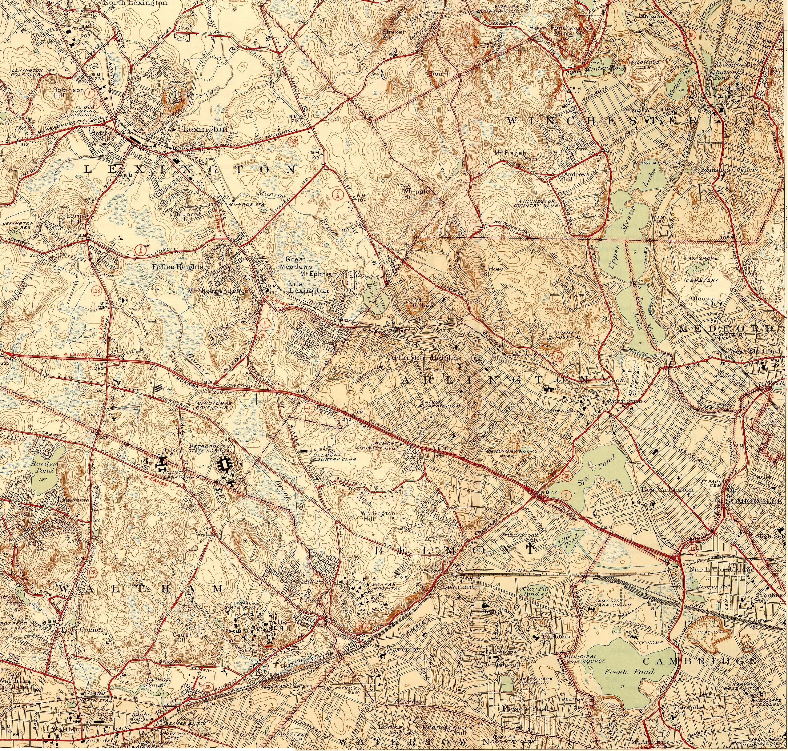
 Topography of Arlington and environs
- ^ Fischer, David Hackett (1994). Paul Revere's Ride. New York, New York: Oxford University Press. ISBN 0-19-508847-6.
- ^ "History". Town of Arlington. http://www.town.arlington.ma.us/Public_Documents/ArlingtonMA_WebDocs/ArlingtonHistory. Retrieved 2008-01-17.
- ^ Schaeffer, K. H. and Elliott Sclar. Access for All: Transportation and Urban Growth. Columbia University Press, 1980. Accessed on Google Books. 86. Retrieved on January 16, 2010. ISBN 0231051654, 9780231051651.
- ^ a b Bricklin: Early Days
- ^ "TOTAL POPULATION (P1), 2010 Census Summary File 1, All County Subdivisions within Massachusetts". United States Census Bureau. http://factfinder2.census.gov/bkmk/table/1.0/en/DEC/10_SF1/P1/0400000US25.06000. Retrieved September 13, 2011.
- ^ "Massachusetts by Place and County Subdivision - GCT-T1. Population Estimates". United States Census Bureau. http://factfinder.census.gov/servlet/GCTTable?_bm=y&-geo_id=04000US25&-_box_head_nbr=GCT-T1&-ds_name=PEP_2009_EST&-_lang=en&-format=ST-9&-_sse=on. Retrieved July 12, 2011.
- ^ "1990 Census of Population, General Population Characteristics: Massachusetts". US Census Bureau. December 1990. Table 76: General Characteristics of Persons, Households, and Families: 1990. 1990 CP-1-23. http://www.census.gov/prod/cen1990/cp1/cp-1-23.pdf. Retrieved July 12, 2011.
- ^ "1980 Census of the Population, Number of Inhabitants: Massachusetts". US Census Bureau. December 1981. Table 4. Populations of County Subdivisions: 1960 to 1980. PC80-1-A23. http://www2.census.gov/prod2/decennial/documents/1980a_maABC-01.pdf. Retrieved July 12, 2011.
- ^ "1950 Census of Population". Bureau of the Census. 1952. Section 6, Pages 21-10 and 21-11, Massachusetts Table 6. Population of Counties by Minor Civil Divisions: 1930 to 1950. http://www2.census.gov/prod2/decennial/documents/23761117v1ch06.pdf. Retrieved July 12, 2011.
- ^ "1920 Census of Population". Bureau of the Census. Number of Inhabitants, by Counties and Minor Civil Divisions. Pages 21-5 through 21-7. Massachusetts Table 2. Population of Counties by Minor Civil Divisions: 1920, 1910, and 1920. http://www2.census.gov/prod2/decennial/documents/41084506no553ch2.pdf. Retrieved July 12, 2011.
- ^ "1890 Census of the Population". Department of the Interior, Census Office. Pages 179 through 182. Massachusetts Table 5. Population of States and Territories by Minor Civil Divisions: 1880 and 1890. http://www2.census.gov/prod2/decennial/documents/41084506no553ch2.pdf. Retrieved July 12, 2011.
- ^ "1870 Census of the Population". Department of the Interior, Census Office. 1872. Pages 217 through 220. Table IX. Population of Minor Civil Divisions, &c. Massachusetts. http://www2.census.gov/prod2/decennial/documents/1870e-05.pdf. Retrieved July 12, 2011.
- ^ "American FactFinder". United States Census Bureau. http://factfinder.census.gov. Retrieved 2008-01-31.
- ^ U.S. Census Bureau figures
- ^ 1970 Census Of Population
- ^ "Town Manager". Town of Arlington. http://www.town.arlington.ma.us/Public_Documents/ArlingtonMA_TownMgr/index. Retrieved 2008-01-17.
- ^ "Board of Selectmen". Town of Arlington. http://www.town.arlington.ma.us/Public_Documents/ArlingtonMA_Selectmen/index. Retrieved 2011-05-27.
- ^ "School Committee". Arlington Public Schools. http://www.arlington.k12.ma.us/asc/. Retrieved 2008-01-17.
- ^ http://www.saintagnesschool.com/about_us.htm
- ^ "National Register Information System". National Register of Historic Places. National Park Service. 2008-04-15. http://nrhp.focus.nps.gov/natreg/docs/All_Data.html.
- ^ Graywolf Press page on Birkerts
- ^ Cinematic biography
- ^ Braithwaite, William Stanley (1972). The William Stanley Braithwaite reader. Ann Arbor, MI: University of Michigan Press.. p. 265.. ISBN 0472081942
- ^ Workman Publishing bio
- ^ "All Men Are Brothers" Run
- ^ Boston Globe obituary
- ^ http://www.dodgefamily.org/Biographies/J/JoshuaEricDodge.shtml
- ^ Dukakis, Olympia (2003). Ask Me Again Tomorrow: A Life in Progress. New York, NY: HarperCollins. ISBN 0-06-093409-3.
- ^ "Roy J. Glauber, Mallinckrodt Professor of Physics, winner 2005 Nobel Prize in Physics". Harvard University Gazette. Archived from the original on 2007-08-16. http://web.archive.org/web/20070816212458/http://www.news.harvard.edu/gazette/daily/2005/10/04-nobel.html. Retrieved 2007-08-01.
- ^ Harpgigs harpist directory
- ^ hockeyDB.com: Andy Powers
- ^ "Director, Mark Sullivan". United States Secret Service. http://www.secretservice.gov/director.shtml. Retrieved 2007-05-20.
- ^ http://www.glennbeck.com/content/articles/article/198/42552/
Further reading
External links
- Official town web site
- arlington-mass.com is a community website for Arlington
- The Advocate - Arlington's weekly newspaper
- [4] Webcast of magazine-format Arlington Cable Access (Public-access television) cable TV show The Menotomy Journal
- Arlington Emergency Management Agency/Auxiliary Fire/Explorer Post 911
- Arlington on NPR Weekend America program, December 22, 2007
- Arlington Patriots Day Parade
Municipalities and communities of Middlesex County, Massachusetts Cities 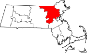
Towns Acton | Arlington | Ashby | Ashland | Ayer | Bedford | Belmont | Billerica | Boxborough | Burlington | Carlisle | Chelmsford | Concord | Dracut | Dunstable | Framingham | Groton | Holliston | Hopkinton | Hudson | Lexington | Lincoln | Littleton | Maynard | Natick | North Reading | Pepperell | Reading | Sherborn | Shirley | Stoneham | Stow | Sudbury | Tewksbury | Townsend | Tyngsborough | Wakefield | Wayland | Westford | Weston | Wilmington | Winchester
CDPs Ayer | Cochituate | Fort Devens | East Pepperell | Groton | Hopkinton | Hudson | Littleton Common | Pepperell | Pinehurst | Shirley | Townsend | West Concord
Other
villagesAuburndale | Chestnut Hill | Gleasondale | Nabnasset | Newton Centre | Newton Highlands | Newton Lower Falls | Newton Upper Falls | Newtonville | Nonantum | North Billerica | North Chelmsford | Waban | West Newton
Categories:- Towns in Middlesex County, Massachusetts
- Arlington, Massachusetts


Wikimedia Foundation. 2010.