- Mount Annan, New South Wales
-
Mount Annan
Sydney, New South Wales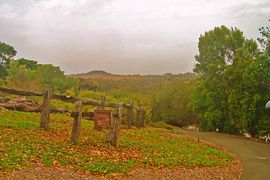
Mount Annan Botanic GardensPopulation: 6,642 (2001) Postcode: 2567 Location: 60 km (37 mi) south-west of Sydney CBD LGA: Camden Council Region: Macarthur State District: Camden Federal Division: Macarthur Suburbs around Mount Annan: Smeaton Grange Currans Hill Blairmount Narellan Vale Mount Annan Campbelltown Spring Farm Menangle Park Glen Alpine Mount Annan is a suburb of Sydney in the state of New South Wales, Australia. Mount Annan is located 60 kilometres south-west of the Sydney central business district, in the local government area of Camden Council and is part of the Macarthur region.
Contents
History
The area now known as Mount Annan was originally home to the Dharawal people, based in the Illawarra region, although the Western Sydney-based Darug people and the Southern Highlands-based Gandangara people were also known to have inhabited the greater Camden area. Very early relations with British settlers were cordial but as farmers started clearing and fencing the land affecting food resources in the area, clashes between the groups arose until 1816 when a number of indigenous people were massacred and the remainder retreated from direct conflict with the settlers.[1]
In 1805, wool pioneer John Macarthur was granted 5,000 acres (20 km²) at Cowpastures (now Camden). After the land was cleared, it was used for farming for most of the next 200 years until Sydney's suburban sprawl reached the town of Camden and modern suburbs like Mount Annan were subdivided into housing blocks.[1]
Transport
Mount Annan is off the M5 motorway and Hume Highway. It includes the locality formerly known as Glenlee and the former Glenlee coal loader, which served the former Burragorang Valley coal mines. There are a number of bus services that run through the suburb. The nearest railway station is Macarthur.
Education
There are two local schools in the area. Mount Annan Public School (MAPS) was built in 1993 and is located on Stenhouse Drive. Mount Annan High School (MAHS) was built in 2003 and is located on Welling Drive.
Landmarks
Mount Annan Botanic Garden is primarily a native garden but is equipped with barbecuing facilities and picnic areas. Mount Annan is a hill within the grounds and there is a track in the gardens to the summit. Sundial Hill is another landmark of the gardens and there is a water feature area.
Demographics
In the 2001 Australian Bureau of Statistics Census, the suburb of Mount Annan had a population of 6,642 people with a very high percentage of families with children (63%). The suburb is almost entirely detached houses (99.7%) with just seven dwellings recorded as either apartments or townhouses. A very high percentage of these houses are mortgaged (64%), well over double the national average (27%).[2]
Governance
Mount Annan lies in the central ward of Camden Council, currently represented by Fred Anderson, Rob Elliott and Debby Dewbery. It sits within the state electorate of Camden, represented by Labor's Geoff Corrigan, the former Mayor of Camden, and the federal electorate of Macarthur, represented by Liberal's Pat Farmer, the former ultra-marathon runner.
References
- ^ a b ""The History of Camden"". Camden Historical Society. http://www.camdenhistory.org.au/chcamden.html. Retrieved 2008-03-20.
- ^ Australian Bureau of Statistics (9 March 2006). "Mount Annan (State Suburb)". 2001 Census QuickStats. http://www.censusdata.abs.gov.au/ABSNavigation/prenav/LocationSearch?collection=Census&period=2001&areacode=SSC12616&producttype=QuickStats&breadcrumb=PL&action=401. Retrieved 2007-06-30.
Coordinates: 34°03′54″S 150°45′36″E / 34.065°S 150.760°E
Suburbs and localities within Camden Council · Macarthur · South-western Sydney · Sydney Bickley Vale · Camden · Camden South · Catherine Field · Cobbitty · Currans Hill · Elderslie · Ellis Lane · Grasmere · Harrington Park · Kirkham · Leppington · Mount Annan · Narellan · Narellan Vale · Oran Park · Smeaton Grange · Spring FarmList of Sydney suburbs Categories:- Suburbs of Sydney

Wikimedia Foundation. 2010.