- 2004 Pacific typhoon season
Infobox hurricane season
Basin=WPac
Year=2004
Track=2004 Pacific typhoon season summary.jpg
First storm formed=April 5 ,2004
Last storm dissipated=December 21 ,2004
Strongest storm name=Chaba
Strongest storm pressure=910
Strongest storm winds=110
Average wind speed=10
Total storms=29
Total hurricanes=19
Total intense=6
Fatalities=2,073
five seasons=2002, 2003, 2004, 2005, 2006|}The 2004 Pacific typhoon season has no official bounds; it ran year-round in 2004, but mosttropical cyclones tend to form in the northwesternPacific Ocean between May and November. [http://www.typhoon2000.ph/garyp_mgtcs/may03sum.txt] These dates conventionally delimit the period of each year when most tropical cyclones form in the northwesternPacific Ocean .The scope of this article is limited to the Pacific Ocean, north of the equator and west of the
international date line . Storms that form east of the date line and north of the equator are called hurricanes; see2004 Pacific hurricane season . Tropical Storms formed in the entire west pacific basin are assigned a name by the Tokyo Typhoon Center. Tropical depressions in this basin have the "W" suffix added to their number. Tropical depressions that enter or form in the Philippine area of responsibility are assigned a name by thePhilippine Atmospheric, Geophysical and Astronomical Services Administration or PAGASA. This can often result in the same storm having two names.torms
In storm information below, wind-speed advisories differ from the
Joint Typhoon Warning Center (JTWC) to the JMA as the JTWC uses theUnited States criteria of 1-minute mean to designate maximum sustained winds, while the JMA uses the 10-minute mean wind criteria to designate tropical cyclone maximum sustained winds. This difference generally results in JTWC maximum winds appearing higher than the maximum winds described by the JMA for the same cyclone.Typhoon Sudal (Cosme)
Infobox Hurricane Small
Basin=WPac
Track=Sudal 2004 track.pngApril 5
Dissipated=April 16
10-min winds=90
1-min winds=130
Pressure=940April 4 , Tropical Depression 03W began its life betweenChuuk andPohnpei . As it drifted to the northwest, it strengthened into a tropical storm. Sudal turned to the west, and steadily intensified to become atyphoon onApril 6 . On theApril 9 , with maximum sustained winds of 115 kt/130 mph, Typhoon Sudal hit the island ofYap . After ravaging the island, Sudal reached a peak of 125 kt/150 mph winds. The typhoon turned to the northeast and became extratropical on theApril 15 . Yap experienced catastrophic damage, with 90% of buildings destroyed, 1,500 left homeless, and one fatality. Sudal is a Korean word meaning otter. The name was retired following this year.Typhoon Nida (Dindo)
Infobox Hurricane Small
Basin=WPac
Track=Nida 2004 track.pngMay 14
Dissipated=May 21
10-min winds=95
1-min winds=140
Pressure=935monsoon trough spawned Tropical Depression 04W east of thePhilippines onMay 13 . The depression quickly strengthened, reaching tropical storm intensity onMay 14 andtyphoon status just six hours later. OnMay 15 andMay 16 while moving northwest towards thePhilippine coast, Nida rapidly intensified to a 135 kt/160 mph super typhoon, and crossed the easternPhilippines shortly thereafter. Nida weakened slightly over the islands, and began to move to the north and northeast in response to a break in thesubtropical ridge . It becameextratropical onMay 21 east of Japan, after causing 31 deaths and about $1.3 million in damage. Nida is a Thai female name.In the
Philippines , evacuation centers were opened to accommodate 2,986 people. The typhoon approach canceledferry operations stranding 15,057 passengers. [http://www.australiasevereweather.com/cyclones/2004/summ0405.txt May 2004 Monthly Global Tropical Cyclone Summary] ] InTaiwan , forecasters at theCentral Weather Bureau issued a typhoon warning as forecast models predicted a high probability of the typhoon hittingTaiwan . [Central Weather Bureau [http://www.mmm.ucar.edu/mm5/workshop/ws04/PosterSession/Chien.Fang-Ching.pdf#search=%22Typhoon%20Nida%22 A Real-time MM5/WRF Forecasting system in Taiwan] URL Accessed:September 26 ,2006 ]evere Tropical Storm Omais (Enteng)
Infobox Hurricane Small
Basin=WPac
Track=Omais 2004 track.pngMay 18
Dissipated=May 21
10-min winds=50
1-min winds=60
Pressure=985Chuuk organized into a tropical depression onMay 16 , one of 3 active tropical cyclones in the Western Pacific at the time. The depression developed quickly, reaching tropical storm status later that day and reaching a peak of 60 kt/70 mph winds three days later onMay 19 . A weakening ridge brought Omais northward, where it became extratropical onMay 22 . Operationally, Omais was classified as atyphoon , but in post-analysis, it was dropped to a tropical storm. Omais is a Palauan word meaning 'wandering around'.Typhoon Conson (Frank)
Infobox Hurricane Small
Basin=WPac
Track=Conson 2004 track.pngJune 6
Dissipated=June 11
10-min winds=80
1-min winds=100
Pressure=960South China Sea , a stationary area of disturbed weather developed into Tropical Depression 07W onJune 4 . It tracked eastward then northeastward, becoming a tropical storm onJune 5 and a typhoon onJune 7 . Conson passed betweenLuzon andTaiwan , and peaked with 100 kt/115 mph winds onJune 9 . Conson weakened as it continued northeastward, and becameextratropical onJune 11 nearJapan without causing any reported damage. Conson is an area inVietnam containing many historical monuments.evere Tropical Storm Chanthu (Gener)
Infobox Hurricane Small
Basin=WPac
Track=Chanthu 2004 track.pngJune 10
Dissipated=June 13
10-min winds=60
1-min winds=75
Pressure=975June 9 , just east of thePhilippines . It crossed the islands, and strengthened in theSouth China Sea to atyphoon onJune 12 . After peaking with 75 kt/85 mph winds, Chanthu hit centralVietnam onJune 12 , and dissipated the next day. Seven people were killed in the heavy flooding. Chanthu is a type of flower found inCambodia .Typhoon Dianmu (Helen)
Infobox Hurricane Small
Basin=WPac
Track=Dianmu 2004 track.pngJune 13
Dissipated=June 21
10-min winds=100
1-min winds=155
Pressure=915monsoon trough onJune 13 , headed north in the open Western Pacific. On theJune 15 andJune 16 ,Dianmu rapidly intensified from a 70 kt/80 mphtyphoon to a 155 kt/180 mph super typhoon, one of nine typhoons since 1990 to reach that intensity. It lost some organization onJune 18 , but re-strengthened onJune 19 to a super typhoon while south ofOkinawa . Some dry air weakened Dianmu as it continued its northward movement, and hit southernJapan as a 55 kt/65 mph tropical storm onJune 21 . Dianmu becameextratropical that night after causing 3 deaths. Dianmu is the name of the goddess of thunder and lightning in Chinese folklore.Typhoon Mindulle (Igme)
Infobox Hurricane Small
Basin=WPac
Track=Mindulle 2004 track.pngJune 23
Dissipated=July 4
10-min winds=95
1-min winds=125
Pressure=940monsoon trough spawned a tropical depression onJune 23 nearGuam . It tracked westward, becoming a tropical storm that night but slowly strengthening as it continued westward due to vertical wind shear. When the shear abated, Mindulle quickly intensified, reaching typhoon strength onJune 27 and peaking at 125 kt/145 mph winds onJune 28 . Land interaction withLuzon to its south weakened Mindulle, and thetyphoon weakened as it turned northward. OnJuly 1 Mindulle hit easternTaiwan , and after accelerating to the northeast becameextratropical nearSouth Korea onJuly 4 . Mindulle caused 56 deaths, with $317.2 million in damage in its path (2004 USD). Mindulle is the Korean word for thedandelion .Typhoon Tingting
Infobox Hurricane Small
Basin=WPac
Track=Tingting 2004 track.pngJune 26
Dissipated=July 4
10-min winds=80
1-min winds=80
Pressure=955monsoon trough onJune 25 , steadily strengthened as it tracked to the northwest, and reached tropical storm status onJune 26 . Tingting passedSaipan onJune 27 , and reachedtyphoon status early onJune 28 . After maximum sustained winds peaked at 80 kts/90 mph, thetyphoon turned to the northeast, where it becameextratropical onJuly 3 after causing 3 deaths onSaipan . Tingting is a pet name for young girls in Chinese.Tropical Storm Kompasu (Julian)
Infobox Hurricane Small
Basin=WPac
Track=Kompasu 2004 track.pngJuly 14
Dissipated=July 16
10-min winds=45
1-min winds=45
Pressure=992July 13 . Under high vertical shear and with a very small circulation, it was not expected to strengthen further. However, as it tracked erratically westward, it intensified, peaking with 40 kt/50 mph winds onJuly 14 . Kompasu turned northward, hit the eastern part ofHong Kong directly as a minimal tropical storm, and dissipated onJuly 16 . Kompasu is theJapan ese word for compass, and the name of theconstellation Circinus .Typhoon Namtheun
Infobox Hurricane Small
Basin=WPac
Track=Namtheun 2004 track.pngJuly 25
Dissipated=August 2
10-min winds=85
1-min winds=115
Pressure=935July 25 , rapidly intensified onJuly 26 to a 115 kt/135 mphtyphoon . Dry air approached the system from the south, and it weakened as it tracked northwest towardsJapan . OnJuly 31 , Namtheun hit southwestJapan as a 55 kt/65 mph tropical storm, and becameextratropical in theSea of Japan onAugust 1 . The storm caused no deaths or damage, with only 6 injuries. Namtheun is the name of a river inLaos .Tropical Storm Malou
Infobox Hurricane Small
Basin=WPac
Track=Malou 2004 track.pngAugust 4
Dissipated=August 4
10-min winds=40
1-min winds=35
Pressure=996August 4 . It became a minimal tropical storm before hitting centralJapan on the night ofAugust 4 . Malou turned to the northeast and becameextratropical in theSea of Japan onAugust 5 . Malou is the Chinese name for the mineralagate .Typhoon Meranti
Infobox Hurricane Small
Basin=WPac
Track=Meranti 2004 track.pngAugust 4
Dissipated=August 9
10-min winds=75
1-min winds=90
Pressure=960Wake Island onAugust 2 and reached its peak intensity of 90 kts/105 mph onAugust 5 before dissipating onAugust 8 .Meranti was the only one of the six Augusttyphoons which did not affect any populated areas. Meranti is a type of tree found inMalaysia .Typhoon Rananim (Karen)
Infobox Hurricane Small
Basin=WPac
Track=Rananim 2004 track.pngAugust 8
Dissipated=August 13
10-min winds=80
1-min winds=90
Pressure=950August 7 and reached its maximum intensity of 90 kts/105 mph onAugust 12 before making landfall in the Zhejiang Province ofChina later that day. In advance of the storm, 415,000 people were evacuated. Rananim caused as much as 686 mm/27" of rain in parts of Zhejiang, killing 115 people, injuring 1800 and causing US$4 billion in direct economic losses. It was the worsttyphoon to hitChina since Winnie in 1997. Rananim is theChuuk ese word for 'hello'. The name Rananim was retired after this year.Tropical Storm Malakas
Infobox Hurricane Small
Basin=WPac
Track=Malakas 2004 track.pngAugust 11
Dissipated=August 13
10-min winds=45
1-min winds=35
Pressure=990monsoon trough extended from thePhilippine Sea northeastward for hundreds of miles spawned a disturbed area around 22N/150E late onAugust 8 . A weak tropical depression formed out of this area late onAugust 9 . Deep convection was in a cycling mode, and satellite imagery initially indicated that the system was subtropical in nature. The depression was upgraded to Tropical Storm Malakas as it took on a more tropical appearance about 670 miles west-northwest ofWake Island , and it moved northeastward along the northern periphery of thesubtropical ridge . ByAugust 12 , satellite imagery indicated that Malakas was becomingextratropical . JMA declared the systemextratropical on theAugust 14 , placing the weak 25 kt/30 mph low approximately 575 miles north-northwest ofMidway Island . Malakas is a Filipino word meaning 'strong' or 'powerful'. [http://australiasevereweather.com/cyclones/2005/summ0408.htm Monthly Global Tropical Cyclone Summary August 2004 ] ]Typhoon Megi (Lawin)
Infobox Hurricane Small
Basin=WPac
Track=Megi 2004 track.pngAugust 16
Dissipated=August 20
10-min winds=65
1-min winds=65
Pressure=970Guam onAugust 11 , slowly developing into Tropical Depression 18W on theAugust 14 , strengthening into a tropical storm on theAugust 16 , and ultimately into atyphoon on theAugust 18 to the southwest ofJapan . Megi moved northwest through the Ryūkyū islands before recurving northeastward towardsSouth Korea andJapan . Megi sped across northernHonshū before completing its transition into a nontropical low off the east coast ofHokkaidō . The resultant ocean cyclone moved rapidly eastward, reaching a point near 42N/174E late on theAugust 22 .Despite peaking at only minimal typhoon intensity, Megi had a significant impact on both
Japan andSouth Korea . InJapan , the highest storm total rainfall noted was 610 mm at Tomisato betweenAugust 17 andAugust 21 , with 398 mm falling in a 24 hour period. The highest wind gust was 109 mph/48.7 m/s at Izuhara, Nagasaki early on theAugust 19 . The lowest measured pressure was 974.1 mb at Isuhara. InSouth Korea , the heaviest 24 hour rain total was 332.5 mm at Wando between late on theAugust 17 andAugust 18 . News reports indicated that five people were reported dead or missing after Typhoon Megi inSouth Korea . The number left homeless rose to more than 2400. Typhoon Megi left at least ten dead inJapan . Megi's landfall on northernJapan resulted in large blackouts as 130,000 homes were left in the dark. A group of about 165 primary school students were stranded by a Megi-induced landslide in westernJapan , though were successfully rescued by helicopter. Megi is theKorea n word for thecatfish .Typhoon Chaba
Infobox Hurricane Small
Basin=WPac
Track=Chaba 2004 track.pngAugust 19
Dissipated=August 31
10-min winds=110
1-min winds=155
Pressure=910August 18 in the open Western Pacific. It moved westward, strengthening into a tropical storm on theAugust 19 and a typhoon onAugust 20 . Chaba turned to the northwest, and rapidly intensified to a 155 kt/180 mph super typhoon on theAugust 22 with an estimated minimum central pressure of 879 mbar, among the lowest on record. After fluctuating between 100 kt/115 mph and super typhoon status for several days, Chaba weakened as it turned to the north, and hit the southwesternJapan ese island ofHonshū . It accelerated to the northeast, and became extratropical onAugust 31 . The storm killed seven people and brought extensive flooding toHonshū . Chaba is a type of tropical flower.Typhoon Aere (Marce)
Infobox Hurricane Small
Basin=WPac
Track=Aere 2004 track.pngAugust 20
Dissipated=August 26
10-min winds=80
1-min winds=90
Pressure=955Early on the 25th, six villages located in Gaoqiao Town, Yinzhou District, Ningbo City, were struck by a tornado triggered by Typhoon Aere. The tornado did cause some economic losses, but no casualties were reported. Preliminary statistics indicated that the typhoon had caused 2.485 billion yuan of direct economic losses and was responsible for two deaths in Fujian province. Aere also affected 3,479,900 residents in 421 towns of 48 counties of 6 cities in Fujian, where three cities were flooded, 10,100 houses were toppled, 236 embankments and thousands of water conservancy facilities were damaged. Thirty-four people were killed in Taiwan as a result of the storm, and fifteen died as a mudslide buried a remote mountain village in the north of the island. Agricultural losses were estimated at 7.7 million New Taiwan dollars ($US 313,000). Forty-three deaths in the Philippines were caused by heavy rains induced by the typhoon. Eight provinces in northern and central Luzon were most severely affected with 70% of the provinces under water at one point.
Typhoon Songda (Nina)
Infobox Hurricane Small
Basin=WPac
Track=Songda 2004 track.pngAugust 28
Dissipated=September 8
10-min winds=95
1-min winds=125
Pressure=925Storm total rainfall amounts in Japan ranged as high as 905 mm at Morotsuka between the 4th and 9th, with 358 mm falling between the early morning of the 6th and 7th. The highest wind gust of 135 mph/60.2 m/s was measured at Hiroshima. The lowest pressure measured in Japan was 944.3 mb at Saga. In the Republic of Korea, Ulleungdo measured 112.0 mm between the 6th and 7th. News reports indicated that Typhoon Songda killed 20 people and injured 700 others in Japan. In addition, 15 crew members of a vessel were reported missing. Songda arrived shortly after three earthquakes had struck the country a few days prior.
evere Tropical Storm Sarika
Infobox Hurricane Small
Basin=WPac
Track=Sarika 2004 track.pngSeptember 4
Dissipated=September 7
10-min winds=55
1-min winds=60
Pressure=980Tropical Storm Haima (Ofel)
Infobox Hurricane Small
Basin=WPac
Track=Haima 2004 track.pngSeptember 11
Dissipated=September 13
10-min winds=40
1-min winds=35
Pressure=996sea horse . Early on September 11th, an area of thunderstorms was observed 150 nm southwest of Taipei, Taiwan. Later that day, the newly-formed tropical depression saw its thunderstorms track across Taiwan, leaving the circulation center behind east of the mountainous isle as it took on a subtropical appearance. By the 12th, it had strengthened into a tropical storm named Haima by Japan and Ofel by the Philippines...the Joint Typhoon Warning Center considered the system a tropical depression or subtropical storm, but never a tropical storm. The center track just east of Taiwan on the 12th, towards the southeast coast of China. Haima made landfall south of Shanghai on the 13th before turning to the northwest. Haima soon become a completely sheared system due to interaction with the upper level winds over a frontal zone located to its west, and was declared dissipated on the 14th.In China, the lowest reported pressure was 998 mb in Yongqiang Town on the 13th and the highest 24 hour rainfall recorded was 250.8 mm at Pingtan in Fuzhou City between the 09th and 10th, which set a new September daily rainfall record for the station. In Taiwan, daily rainfall ranged as high as 393 mm in Taipei county, and 611.5 mm in Taipei City. The highest wind gust reported was 80 mph/35.9 m/s at Lanyu on the 11th. The storm damaged 78 square kilometres of farmland in Zhejiang Province, China, where direct economic losses were estimated to have been over 53 million yuan. Torrential rains (Sep 7-10), including those in the monsoonal flow around the pre-Haima depression had caused 54.6 million yuan of direct economic losses in Pingtan County and Changle City. In Japan, rainfall and winds were relatively light. In South Korea, the highest 24 hour rainfall report noted was 104.5 mm at Wando between the 11th and 12th.
Typhoon Meari (Quinta)
Infobox Hurricane Small
Basin=WPac
Track=Meari 2004 track.pngSeptember 20
Dissipated=September 30
10-min winds=90
1-min winds=125
Pressure=940The highest wind gust reported was 118 mph/52.7 m/s in Kagoshima early on the 29th. The lowest pressure measured during the passage of Meari was 975.5 mb, also at Kagoshima on the 29th. Three tornadoes were spawned in Japan, with two touching down in Okinawa Prefecture and one in Aichi Prefecture. The heaviest rains in Japan were saved for Osawe, where 904 mm fell between late on the 24th and the 30th, with 741 mm falling between late on the 28th and 29th. Reports indicate that at least 18 people died with several more reported missing as a result of Typhoon Meari. The worst affected areas were the prefectures of Mie and Ehime in Japan where torrential rains caused widespread flooding and mudslides destroyed several homes. Train and ferry services were suspended, stranding thousands of people.
Typhoon Ma-on (Rolly)
Infobox Hurricane Small
Basin=WPac
Track=Ma-on 2004 track.pngOctober 4
Dissipated=October 10
10-min winds=100
1-min winds=140
Pressure=920Hong Kong . Ma-on formed from a cluster of thunderstorms in the vicinity of Guam on September 29th. The small system eventually trekked west-northwesterly. After days of sputtering across the western Pacific, Tropical Depression 26W formed on October 4th, and quickly became named Tropical Storm Ma-on. The system became stationary approximately 650 nm southeast of Okinawa, Japan. PAGASA named the cyclone Rolly when it passed the 135th meridian. On the 5th, a northward drift ensued while well southeast of Okinawa. Upon reaching typhoon intensity late on the 06th, Ma-on turned northwest and ultimately became the sixth super typhoon of the year on the 8th while 250 miles southeast of Okinawa. The typhoon become the worst storm to hit eastern Japan in over ten years, only a week after Typhoon Meari had made landfall in that nation. Ma-on started to accelerate northeastward and its eye began to shrink in diameter and became more ragged. A slow weakening trend materialized as it entered the early stages of extratropical transition. Recurving northeast at a high rate of translation, Ma-on made landfall on the Izu Peninsula, Honshū, Japan, late on the 9th with maximum sustained winds of 90 kts/105 mph. Ma-on weakened rapidly and was downgraded to a tropical storm by the 10th, and quickly completed its transformation into a nontropical low. The remnant system moved more east-northeastward away from eastern Japan before slowing its motion 1100 miles southeast of Hokkaidō.Ma-on was one of the most powerful storms to strike eastern Japan over the last ten years. The highest wind gust reported was 151 mph/67.6 m/s in Irouzaki late on the 9th. The lowest pressure was also recorded at Irouzaki; 964 mb late on the 9th. The typhoon left at least six people dead, and three persons were reported missing. Plane, train and ferry services nationwide were disrupted, stranding thousands of travellers. Heavy downpours also disrupted practice sessions for
Formula One 's Japanese Grand Prix in Suzuka. The highest storm total amount was noted at Omaezaki, where a 413 mm deluge was seen between late on the 6th and 9th, with 360 mm falling in a 24 hour period. Rescuers on boats plucked dozens of residents from waterlogged homes in Shizuoka Prefecture. [http://australiasevereweather.com/cyclones/2005/summ0410.htm Monthly Global Tropical Cyclone Summary October 2004 ] ]Typhoon Tokage (Siony)
Infobox Hurricane Small
Basin=WPac
Track=Tokage 2004 track.pngOctober 13
Dissipated=October 20
10-min winds=85
1-min winds=125
Pressure=940October 13 , the system developed into a tropical storm, and was named Tokage, subsequently moving very close to the islands of Rota and Guam. Typhoon intensity was achieved early onOctober 14 when centered 970 miles southeast of Okinawa. Later that day, Tokage briefly turned to the west-southwest. The storm's path curved back to a northwesterly heading by theOctober 15 . The storm curled towards the north as a major shortwave over weakened the subtropical ridge and byOctober 17 Tokage reached its peak intensity of 125 kts/145 mph. Weakening began later that day as the storm turned back to a more northwesterly heading towards Okinawa and Japan. OnOctober 18 , Typhoon Tokage was 290 miles south of Kadena Air Base, Okinawa. Recurvature back to the north-northeast towards Japan ensued while the typhoon slowly weakened. Tokage made its closest approach to Okinawa late onOctober 19 when it was passed just to the south-southeast. The storm turned to the northeast as continued to accelerate as its extratropical transition began. Tokage made landfall over Tosa-Shimizu, near the southern tip of Shikoku, Japan still at typhoon strength. ByOctober 21 , the cyclone weakened into a tropical storm 130 nm west of Tokyo, and later that day, the system completed the transition to a nontropical low. The extratropical remains of Tokage moved rapidly northeastward, crossing theInternational Dateline around midday onOctober 23 .The highest measured wind gust was 142 mph/63.7 m/s at Unzendake, Nagasaki on
October 20 . The lowest pressure from a land station was 949.4 mb at Okinoerabu, Kagoshima late onOctober 19 . The highest rainfall amount noted in Japan was 550 mm at Fukuharaasahi between late onOctober 17 andOctober 21 , with 470 mm falling within a 24 hour period. News reports indicated Tokage was the worst storm to strike Japan since Typhoon Mireille thirteen years before. A total of 69 deaths were attributed to high winds, flooding and mudslides caused by Tokage. A total of 18,000 people were forced to evacuate their homes.Typhoon Nock-ten (Tonyo)
Infobox Hurricane Small
Basin=WPac
Track=Nock-ten 2004 track.pngOctober 16
Dissipated=October 26
10-min winds=85
1-min winds=110
Pressure=945Nock-ten is taken from a type of bird found in Laos. Typhoon Nock-ten originated from a disturbance that formed amongst the Marshall Islands early onOctober 13 while 45 miles west of Kwajalein Atoll. Tropical Depression 28W developed onOctober 14 about 275 miles east-northeast of Pohnpei and moving westward along the southern periphery of the subtropical ridge. The system assumed a more west-northwesterly track, becoming a tropical storm by late onOctober 16 , and was named Nock-ten. Early onOctober 18 , the storm turned southwest and slowed its forward motion. The system strengthened into a typhoon by noon local time and curved back towards the west. Nock-ten soon accelerated and moved more northwesterly, partially due to the remains of Typhoon Tokage. Typhoon Nock-ten passed 160 miles south ofGuam onOctober 20 . Nock-ten reached its peak intensity of 110 kts/125 mph onOctober 23 as it tracked 480 miles south of Okinawa. Turning to a northerly track, Typhoon Nock-ten passed closest to Taipei during the afternoon ofOctober 25 , lying just off the northeastern tip of Taiwan by evening. The storm weakened and by local midnight the track became north-northeast. Nock-ten's motion to the east-northeast accelerated to 26 kts/29 mph, and the typhoon had become a nontropical low by the evening ofOctober 26 . Typhoon Nock-ten lashed northern Taiwan with powerful winds and driving rain. The highest 24 hour rainfall on the island was 322 mm in Taipei City between earlyOctober 25 andOctober 27 . The highest wind gust measured was 122 mph/54.4 m/s in Lanyu onOctober 24 . Three fatalities occurred as a result of flash flooding. In Japan, the highest rainfall amount was spotted at Tanegashima which recorded 133.5 mm between middayOctober 26 andOctober 27 .Typhoon Muifa (Unding)
Infobox Hurricane Small
Basin=WPac
Track=Muifa 2004 track.pngNovember 14
Dissipated=November 25
10-min winds=80
1-min winds=115
Pressure=950ume blossom. The disturbance that was to become Typhoon Muifa was noted early on November 14th when located 215 nm north of Palau. It became Tropical Depression 29W later that day and strengthened into a tropical storm by early the 15th when centered 550 miles east-southeast of Manila, Philippines. PAGASA assigned the name Unding on the 14th as it passed the 135th meridian. On the 16th, the tropical cyclone started drifting north-northeast. Muifa turned back onto a west-northwest heading and intensified. It reached typhoon intensity on the 17th just prior to beginning a two-day clockwise loop. Late on the 18th, Muifa's intensity peaked at 115 kts/130 mph still to the east of the Philippines. Muifa/Unding made landfall very late on the 19th near Naga City with maximum winds of 70 kts/80 mph. The system ambled across the Philippine Archipelago, dropping down to tropical storm intensity on the afternoon of the 20th. On the 21st, Muifa regained typhoon intensity in the South China Sea. Now moving west-southwest, early on the 22nd Muifa re-strengthened into a 90-kt/105 mph typhoon 440 miles east of Ho Chi Minh City, Vietnam. Muifa held onto typhoon status until late on the 23rd when its weakened to a tropical storm once more. On the 25th, Tropical Storm Muifa accelerated westward at a 21 kt/23 mph clip. By early on the 26th, a weakening Tropical Depression Muifa was located 250 nm south of Bangkok, Thailand. Later that day Muifa turned northward into an environment of increased wind shear and dissipated 120 nm south-southwest of Bangkok.The highest 24 hour rainfall amount from the Philippines was 246.4 mm at Catanduanes between midday the 15th and 16th. The lowest pressure at Naga City was 986.1 mb early on the 16th. The death toll reported from the Philippines was 68 dead, 160 injured, and 69 unaccounted for. A total of 26,238 houses were destroyed and 76,062 damaged; total damage reached 1.0089 billion pesos. Typhoon Muifa had a destructive impact on Vietnam. The highest 24-hour rainfall amount reported was 251.5 mm at Prachuap Khirikhan between the afternoon of the 25th and 26th. Floods and landslides triggered by the typhoon killed about 40 people, and 40 more people were reported missing. There were also many villages in the mountains which needed urgent relief but which could not be quickly reached. Hoi An, which is the town of world heritage, was hit by the flood, and more than 80 old houses were in danger of collapse. [http://www.australiasevereweather.com/cyclones/2005/summ0411.htm Monthly Global Tropical Cyclone Summary November 2004 ] ]
Tropical Storm Merbok (Violeta)
Infobox Hurricane Small
Basin=WPac
Formed=November 22
Dissipated=November 22
10-min winds=35
Pressure=1000Merbok is the Malaysian word for the spotted-necked dove. This is the first tropical cyclone recognized by the Japan Meteorological Agency, but not Joint Typhoon Warning Center, since Changmi in 2002. Tropical Storm Merbok emanated from a disturbance located in the Philippine Sea and was first recognized as Tropical Depression Violeta by PAGASA on November 22nd. Later that day, it developed into a tropical storm. Tropical Storm Merbok tracked slowly towards the northwest and made landfall south of Baer on the east coast of Luzon. The storm's intensity held steady at 35 kts/40 mph (its peak strength) as it ambled its way across the mountains of Luzon, finally emerging off the northwest coast late on the 23rd. By this time, Merbok had lost most or all of its deep convection, the remnants continuing slowly north-westwards before dissipating southwest of Taiwan.Tropical Storm Merbok added to the misery caused by Typhoon Muifa/Unding in the Philippines, killing 31 people and injuring 187 others. In addition, 17 persons were reported missing. A total of 337 houses were destroyed and 1,286 damaged. Total estimated damage reached 253 million pesos with agriculture especially hard hit (210 million pesos.) The heaviest rainfall in the Philippines from this cyclone was 185.2 mm at Casiguran between midday the 22nd and 23rd.
Typhoon Nanmadol (Yoyong)
Infobox Hurricane Small
Basin=WPac
Track=Nanmadol 2004 track.pngNovember 29
Dissipated=December 4
10-min winds=90
1-min winds=130
Pressure=935November 28 when it was located 155 nm south-southwest of Pohnpei. It developed into Tropical Depression 30W about 690 miles east-southeast of Yap, and into Tropical Storm Nanmadol by middayNovember 29 as it moved westward south of the subtropical ridge. Nanmadol continued to strengthen, reaching typhoon intensity late that day after passing south of Satawal. The storm's track curved to the west-northwest. Late onNovember 30 , the storm passed just north of Yap, bringing typhoon-force gusts and sustained tropical storm strength winds. The tropical cyclone reached its peak intensity of 130 kts/150 mph midday onDecember 2 , then a super typhoon, 220 miles east of Manila, Philippines. Super Typhoon Nanmadol soon arrived at the Luzon coastline. At this time, the system began to lose strength and was downgraded from super typhoon status.Turning northwestward Typhoon Nanmadol took roughly six hours to cross the island of Luzon, and by early on
December 3 had reemerged back over water. The northwesterly turn took Nanmadol into a weakness in the subtropical ridge before being lured away by a major shortwave trough. Nanmadol weakened markedly duringDecember 3 as it gradually veered more towards the north. The cloud pattern became increasingly asymmetrical as Nanmadol moved east-northeastward across southern Taiwan before becoming extratropical during the afternoon ofDecember 4 . Nanmadol became the first known December tropical cyclone in the past 108 years to make landfall on the island. The remnants of Super Typhoon Nanmadol continued to rapidly move to the east-northeast and northeast and ultimately merged with another LOW, forming a powerful extratropical cyclone which brought strong winds and led to unseasonably warm temperatures to Japan.Because Muifa, Merbok, Winnie, and Nanmadol all occurred within a space of two weeks, the exact number of casualties and total cost of damages is difficult to determine. Nanmadol caused at least 70 fatalities and 157 injuries. Nanmadol destroyed 10,457 houses and damaged 57,435. Agriculture also suffered badly as a result of this typhoon with losses amounting to 2,036 million pesos in the Philippines. The maximum rain in the Philippines was 228.1 mm at Daet between midday on
December 2 andDecember 3 . In Taiwan, as much as 907 mm fell in Hualien county between earlyDecember 3 andDecember 4 . Puluowan reported the highest storm total accumulation of 1090 mm during the 35-hr period ending on the afternoon ofDecember 4 . In China, 106.3 mm fell at Dachen Dao between the morning ofDecember 3 andDecember 4 . In Taiwan, 2 deaths were reported, and agricultural losses there were estimated to have been $670 million New Taiwan dollars.Tropical Storm Talas (Zosimo)
Infobox Hurricane Small
Basin=WPac
Track=Talas 2004 track.pngDecember 10
Dissipated=December 19
10-min winds=40
1-min winds=50
Pressure=994December 10 nearKwajalein , became a tropical storm later that day. Talas moved to the west, peaking at 45 kt/50 mph before weakening due to lack of outflow. A break in the subtropical ridge allowed Talas to turn northward, where it reached 45 kt/50 mph winds before dissipating onDecember 19 . Talas is Filipino for 'acuteness' or 'sharpness'.Tropical Storm Noru
Infobox Hurricane Small
Basin=WPac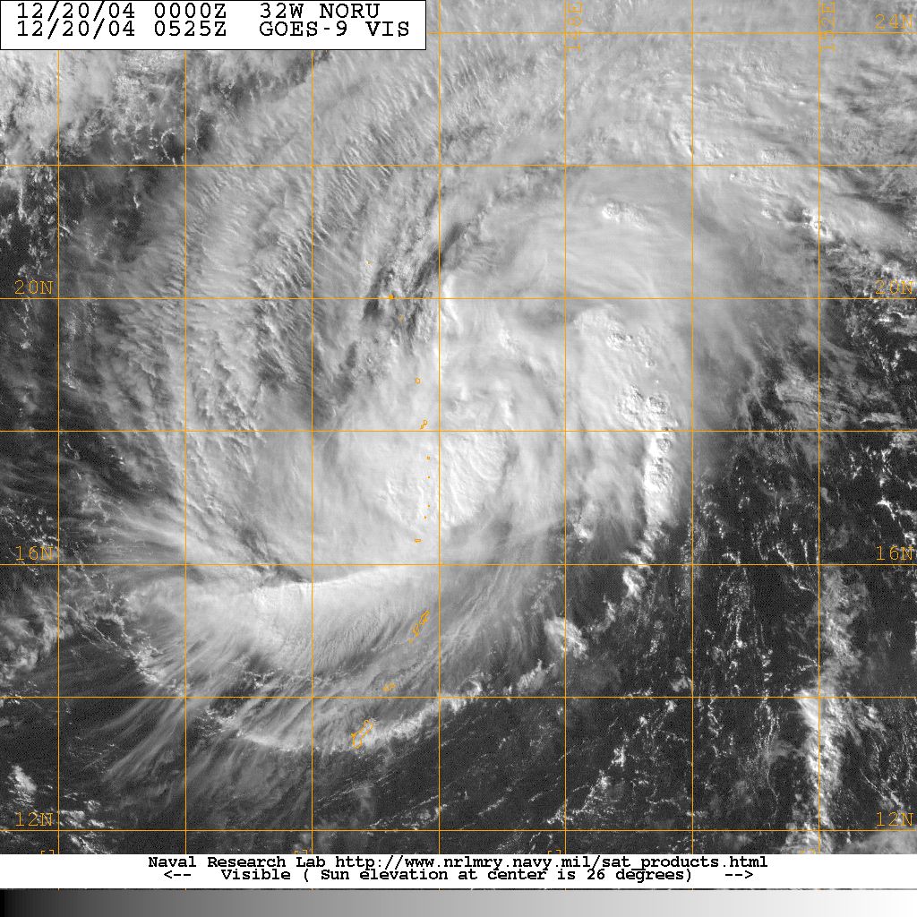
Track=Noru 2004 track.pngDecember 17
Dissipated=December 22
10-min winds=40
1-min winds=55
Pressure=990December 17 to the east-southeast ofSaipan . After becoming a tropical storm onDecember 18 Noru moved to the northwest, where it peaked with 55 kt/65 mph winds. Noru turned to the northeast, and became extratropical onDecember 21 . Noru is the Korean word for theroe deer .Other storms
These systems were not officially named as tropical storms by the JMA, although the JMA might have monitored them as tropical depressions. They were, however, designated as tropical cyclones by the Philippines (PAGASA), China (CMA), and/or the Joint Typhoon Warning Center (JTWC).
Tropical Storm 01W (Ambo)
Infobox Hurricane Small
Basin=WPac
WarningCenter=PAGASA
Track=1-W 2004 track.pngFebruary 11
Dissipated=February 18
10-min winds=30
1-min winds=40
Pressure=994February 11 west ofChuuk . It tracked to the west, organizing slowly due to persistent vertical shear. OnFebruary 13 andFebruary 14 , the depression executed a clockwise loop. When the storm turned to the southwest, the vertical wind shear overcame it, and the storm dissipated onFebruary 16 .Tropical Storm 02W (Butchoy)
Infobox Hurricane Small
Basin=WPac
WarningCenter=PAGASA
Track=2-W 2004 track.pngMarch 16
Dissipated=March 23
10-min winds=45
1-min winds=35
Pressure=997Philippines onMarch 14 . It headed generally northwestward, with a brief turn to the southwest. Just before the storm was about to hit thePhilippines , a trough brought it northward, where dry air and vertical shear caused it to dissipate onMarch 23 .Tropical Storm 05W
Infobox Hurricane Small
Basin=WPac
Track=5-W 2004 track.pngMay 14
Dissipated=May 18
1-min winds=40
Pressure=997May 15 toMay 17 , Tropical Depression 05W persisted in theSouth China Sea before dissipating over open waters.Tropical Storm 21W
Infobox Hurricane Small
Basin=WPac
Track=21-W 2004 track.pngAugust 26
Dissipated=August 28
1-min winds=30
Pressure=1000Tropical Depression Pablo
Infobox Hurricane Small
Basin=WPac
WarningCenter=PAGASA
Formed=September 15
Dissipated=September 17
10-min winds=30
Pressure=1000This system was considered a tropical depression by JMA, PAGASA, the CWB of Taiwan and the Thai Meteorological Department with PAGASA assigning the name Pablo. JTWC released no warnings, but issued a pair of tropical cyclone formation alerts (TCFA) early on the 17th and 18th. Tropical Depression Pablo formed deep in the Philippine Sea east of Mindanao, moved westward across that island, thence turning northwestward and emerging into the South China Sea near the Calamian Group. After crossing the Philippine Archipelago the depression began to slowly weaken but limped across the South China Sea to near the central Vietnamese coastline before dissipating on the 18th where it dropped moderate to heavy rainfall. The maximum winds estimated by any agency were 30 kts/35 mph.Tropical Depression Winnie
Infobox Hurricane Small
Basin=WPac
WarningCenter=PAGASA
Track=Winnie 2004 track.pngNovember 27
Dissipated=November 29
10-min winds=30
Pressure=1000According to news reports in the Philippines, 1,404 people were killed or left missing [http://www.swissre.com/INTERNET/pwsfilpr.nsf/vwFilebyIDKEYLu/SROS-6MQDPM/$FILE/C_2004.pdf] during the passage of Tropical Depression Winnie, primarily due to massive flashfloods and landslides in Quezon and Aurora Provinces triggered by the attendant heavy rains. The highest rainfall report from this system was 157.8 mm from Cabanatuan between midday
November 29 andNovember 30 .torm names
Western North Pacific tropical cyclones are named by the RSMC Tokyo-Typhoon Center of the
Japan Meteorological Agency . Names are selected from the following sequential list, there is no annual list. Names were contributed by 13 members of theESCAP/WMO Typhoon Committee , except forSingapore . The 13 nations or territories, along withMicronesia , each submitted 10 names, which are used in alphabetical order by the English name of the country. These are the same names used for the 2003 season, with the exceptions of Peipah, Matmo, Nuri and Molave, which replaced Vamei, Chataan, Rusa and Imbudo. The first storm of 2004 was named Sudal and the final one was named Noru.Philippines
The
Philippine Atmospheric, Geophysical and Astronomical Services Administration (PAGASA) uses its own naming scheme for tropical cyclones within its area of responsibility. Lists are recycled every four years.The names Unding, Violeta and Winnie were retired after this season.ee also
*
List of Pacific typhoon seasons
*2004 Pacific hurricane season
*2004 Atlantic hurricane season
*2004 North Indian Ocean cyclone season
*South-West Indian Ocean cyclone seasons: 2003-04, 2004-05
*Australian region cyclone seasons: 2003-04, 2004-05
*South Pacific cyclone seasons: 2003-04, 2004-05References
External links
* [http://www.typhoon2000.ph Typhoon2000 Philippine typhoon website] .
* [http://www.typhoon2000.ph/plotting/PhilippineTyphoonChart.gifPhilippine Area of Responsibility] .
* [https://metocph.nmci.navy.mil/jtwc.html Joint Typhoon Warning Center] .
* [https://metocph.nmci.navy.mil/jtwc/atcr/2004atcr/ Joint Typhoon Warning Center 2004 reports]
* [http://www.weather.gov.hk/informtc/sound/tc_pronunciatione.htm Meaning of Tokyo Typhoon Centre names]
* [http://australiasevereweather.com/cyclones/tc2004bt.htm Gary Padgett Tropical Cyclone reports (Jan. to June)]
* [http://australiasevereweather.com/cyclones/tc2005bt.htm Gary Padgett Tropical Cyclone reports (July to Dec.)]
* [http://www.typhoon2000.ph/stormarchives/2004/trax/ Tracks of the 2004 storms]
Wikimedia Foundation. 2010.