- Bexley North, New South Wales
-
Bexley North
Sydney, New South Wales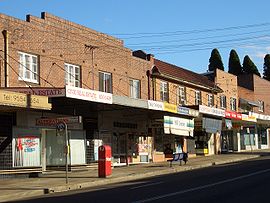
Shaw Street, Bexley NorthPopulation: 3,759 Postcode: 2207 Location: 13 km (8 mi) south of Sydney CBD LGA: City of Rockdale State District: Kogarah Federal Division: Barton Suburbs around Bexley North: Kingsgrove Clemton Park Earlwood Kingsgrove Bexley North Bardwell Park Bexley Bexley Bexley  Corner of Bexley Road and Slade Road, Bexley North
Bexley North is a suburb in southern Sydney, in the state of New South Wales, Australia. It is located 13 kilometres south of the Sydney central business district and is part of the St George area. Bexley North is in the local government area of the City of Rockdale.
Contents
History
James Chandler named Bexley after his birthplace in London (formerly Kent), England. Chandler bought Sylvester’s Farm in 1822, from Thomas Sylvester who had been granted the land about ten years earlier. That year he was also granted 1,200 acres (4.9 km2) of land which stretched from what is now Bexley North to most of Rockdale and Kogarah. Development in the area began in 1884 with the railway line to Hurstville.
The opening of the East Hills line and the railway station at Bexley North in 1931, opened up the area for home sites.[1]
In 2011, an unprecedented promotion of Bexley North shops by the Bexley North Chamber of Commerce took place. This included giveaways, public talks and presentations, cocktail tasting at the local pub, and even free showbags and vases from Olsens Funerals (a funeral parlour).
Commercial area
Bexley North is mostly a residential suburb with a small shopping centre located around the intersection of Bexley Road with Slade Road and Shaw Street, close to Bexley North railway station. It features a Flemings supermarket, a pub, specialty shops including a prominently placed funeral parlour, cafes and restaurants.
Transport
Bexley North railway station is on the East Hills line of the CityRail network. Bexley North is also serviced by State Transit Authority bus routes and private bus routes.
The M5 South Western Motorway runs south-west towards Beverly Hills and Liverpool. There are no entrances at Bexley North to the 4 km tunnel which begins here and heads north-east towards Botany and the city. Access to the north east of the motorway is allowed at Kingsgrove and Arncliffe.
Landmarks
- Bardwell Creek and the Prime Minister's Walk to Bexley Pool
- Bexley North Hotel
- Bexley North Library
- Bexley North Public School
- Bexley North Scout Hall
- Holy Trinity Anglican Church
- Stotts Reserve
- The Art of Cakes Patisserie
Population
Demographics
According to the 2006 Australian Bureau of Statistics Census of Population, there were 3,759 people usually resident in Bexley North. 39.3% stated they were born overseas with the top countries of birth being Greece 6.6%, China 5.3% and New Zealand 2.6%. English was stated as the only language spoken at home by 44.5% of residents and the most common other languages spoken were Greek 19.3%, Cantonese 7.7% and Arabic 6.4%. The most common responses for religious affiliation were and Orthodox 26.7%, Catholic 26.6% and Anglican 9.3%.[2]
Notable residents
- Bob Windle, gold medallist in the Men's 1500m Swimming Freestyle at the 1964 Summer Olympics, grew up in the suburb.
- Tim Cahill, Australian footballer, playing for the Socceroos and Everton was a student at Bexley North Primary School.
References
- ^ The Book of Sydney Suburbs, Compiled by Frances Pollon, Angus & Robertson Publishers, 1990, Published in Australia ISBN 0-207-14495-8, page 28
- ^ http://id.com.au/dosydney/default.aspx?pg=1&gid=680
- ^ "Cahill mobbed at old school". The Sydney Morning Herald. 2006-07-04. http://www.smh.com.au/news/aussie-update/hero-tim-mobbed-at-old-school/2006/07/03/1151778872678.html. Retrieved 2008-02-24.
- ^ "Tim Cahill returns to Bexley North". Bexley North Primary school. http://www.bnps.nsw.edu.au/bnps/?module=News&action=showNews&newsId=13. Retrieved 2008-02-24.
- ^ "Tim Cahill named school sport ambassador by Premier Iemma". ninemsn.com.au. http://news.ninemsn.com.au/article.aspx?id=267848. Retrieved 2008-02-24.
External links
- Bexley North, New South Wales is at coordinates 33°56′30″S 151°06′41″E / 33.94179°S 151.11144°ECoordinates: 33°56′30″S 151°06′41″E / 33.94179°S 151.11144°E
Suburbs and localities within the City of Rockdale · St George · Sydney Arncliffe · Banksia · Bardwell Park · Bardwell Valley · Bexley · Bexley North · Brighton-Le-Sands · Carlton · Dolls Point · Kingsgrove · Kogarah · Kyeemagh · Monterey · Ramsgate · Ramsgate Beach · Rockdale · Sandringham · Sans Souci · Sydney Airport · Turrella · Wolli Creek
Categories:- Suburbs of Sydney


Wikimedia Foundation. 2010.