- Mortensrud (station)
-
Mortensrud 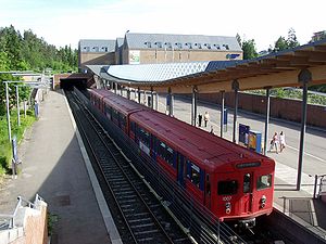
Location Place Mortensrud, Søndre Nordstrand Municipality Oslo Coordinates 59°50′57″N 10°49′40″E / 59.84917°N 10.82778°ECoordinates: 59°50′57″N 10°49′40″E / 59.84917°N 10.82778°E Line Østensjø Line Distance 13.6 km (8.5 mi) Service Opened 24 November 1997 Type At-grade Line(s) 
Connections Bus 71 Bjørndal
71E Bjørndal – Jernbanetorget
72A Dal – Kantarellen
72B Brenne – Kantarellen
73 Bjørndal – Helsfyr
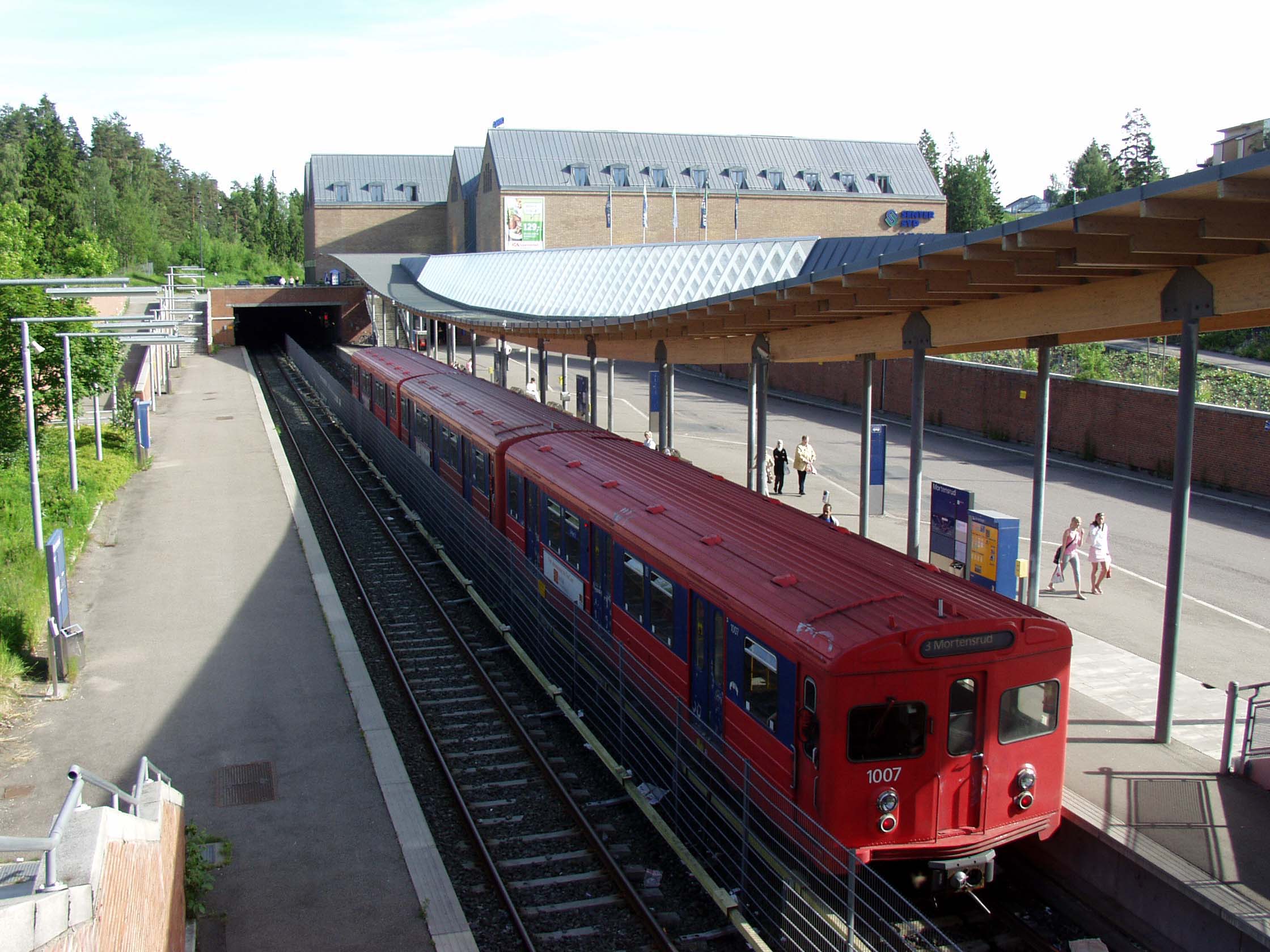
74 Vestbanen/VikaMortensrud is a rapid transit station on the Østensjø Line of the Oslo Metro. It is located in Mortensrud in the Søndre Nordstrand borough of Oslo, Norway. Construction of the station started in 1995, which was taken into use on 24 November 1997, when it became the terminal station of the line—following a 2.4 kilometres (1.5 mi) extension from Skullerud. The extension cost NOK 215 million to build, and most of the section is in tunnels. The station is built in concrete, wood and stone, and cost NOK 35 million. It is served by line 3, in addition to being an important bus terminal for the borough, including a feeder service to Bjørndal. Travel time along the 13.6-kilometre (8.5 mi) section to the city center is 24 minutes. In 2001–02, the station had 2,077 daily boarding passengers. The station serves the surrounding residential area, as well as an adjacent shopping center. South of the station is a turning line for trains.
Contents
History
The Østensjø Line opened as a light rail on 18 December 1923. On 29 October 1967, the upgraded metro standard was first used, and the line was connected to the Oslo Metro. A month later, the extension to Skullerud opened.[1] The work with building the extension between Skullerud and Mortensrud was originally planned to start in 1992, with completion planned for 1994.[2] However, construction did not start until 1995. The 2.4-kilometre (1.5 mi) extension is built to allow speeds of 100 kilometres per hour (62 mph), and represents a considerable longer distance between stations than what is normal on the network. Most of the section is in tunnels, though there are also two viaducts. The extension (without the new station) cost NOK 215 million. The line runs somewhat south of the station, allowing space to line up trains, and for future further extension of the line.[3]
The station was taken into use on 24 November 1997, but not officially opened until 4 January 1998.[1][4] On the day of the official opening, the bus terminal was taken into use. The station costs NOK 35 million.[5] At the time, it was estimated to have about 6000 daily users—both boarding and disembarking, including the bus terminal.[6]
Facilities
The station is located in the residential area of Mortensrud, in Søndre Nordstrand. Mortensrud is an open station without any barriers and free access from the bus stops. The station area is one storey below from the surrounding area. It has step-free access, and at the same level as the buses. Only the western portion of the two side platforms is in use, where direct connection can be made with buses. The station is located adjacent to the shopping center at Mortensrud.[5] The station is designed by Arkitektskap. It is built in concrete, covered in red brick, steel, natural rock and wood, that will allow lianas to grow on them. The roofover the western platform is curved, and made of wood and glass. There is an underground parking lot in two levels.[7]
Service
Mortensrud is served by line 3 on the Østensjø Line, operated by Oslo T-banedrift on contract with Ruter. The rapid transit serves the station every 15 minutes, except in the late evening and on weekend mornings, when there is a 30-minute headway.[8] Travel time along the 13.6-kilometre (8.5 mi) portion to Stortinget in the city center is 24 minutes.[1][6] In 2001–02, the station had 2,077 daily boarding passengers.[9]
The station functions as a major bus terminal for Søndre Nordstrand. Ruter operates feeder bus services to Dal, Brenna, Kantarellen (all no. 72) and Bjørndal (no. 71). The station is the end station of route 74 to the city center, and an intermediate stop on route 76 to Helsfyr and Hvervenbukta. Routes 71E and 73 to the city center also serve the station during rush hour.[10]
References
- ^ a b c Ruter (11 March 2008). "T-banestasjonene i øst" (in Norwegian). http://ruter.no/Miljo-og-kultur/Stasjoner/T-banestasjonene-i-ost/. Retrieved 18 March 2009.
- ^ Grue, Øystein (24 February 1992). "Millioner løser trafikkflokene" (in Norwegian). Aftenposten Aften: p. 15.
- ^ Oslo Package 2. "Mortensrud - T-baneforlengelse" (in Norwegian). http://www.avinet.no/Oslopakke2/database/faktaark_ny.aspx?id=44. Retrieved 21 March 2009.
- ^ Bjerke, Thor and Finn Holom (2004). Banedate 2004. Hamar/Oslo: Norwegian Railway Museum/Norwegian Railway Club. p. 348. ISBN 82-90286-28-7.
- ^ a b Oslo Package 2. "Mortensrud - ny terminal" (in Norwegian). http://www.avinet.no/Oslopakke2/database/faktaark_ny.aspx?id=45. Retrieved 21 March 2009.
- ^ a b Five, Henriette (19 August 1997). "Rødt og dyrt på Mortensrud" (in Norwegian). Aftenposten Aften: p. 10.
- ^ Arkitektskap. "Mortensrud T-banestasjon og bussterminal" (in Norwegian). http://www.arkitektskap.no/samferdsel.html. Retrieved 21 March 2009.
- ^ Ruter (18 August 2008). "Rutetider T-banen" (in Norwegian). http://www1.trafikanten.no/trafikkinfo/tabeller/os/080818_T-bane.pdf. Retrieved 21 March 2009.
- ^ Municipality of Oslo (2003). "Strategi for kollektivtrafikkens utvikling" (in Norwegian) (PDF). http://www.byradsavdeling-for-miljo-og-samferdsel.oslo.kommune.no/getfile.php/Byr%C3%A5dsavdeling%20for%20milj%C3%B8%20og%20samferdsel/Internett/Dokumenter/bystyremelding/nyhetsarkiv/kollektivmelding_bystyremelding.pdf. Retrieved 31 March 2009.
- ^ Ruter (2007). "Linjekart buss syd" (in Norwegian). http://ruter.no/Global/PDF_filer/linjekart/BussSyd2007-10Web.pdf. Retrieved 21 March 2009.
External links
TERMINUS NEXT STATION
← WESTMortensrud NEXT STATION
EAST→TERMINUS Sognsvann Skullerud Line 3 Terminus Mortensrud Categories:- Oslo Metro stations in Oslo
- Railway stations opened in 1997
- 1997 establishments in Norway
Wikimedia Foundation. 2010.