- Diamond Harbour
-
For other uses, see Diamond Harbour (disambiguation).
Diamond Harbour — town — Coordinates 22°12′N 88°12′E / 22.2°N 88.2°ECoordinates: 22°12′N 88°12′E / 22.2°N 88.2°E Country India State West Bengal District(s) South 24 Parganas Parliamentary constituency Diamond Harbour Assembly constituency Diamond Harbour Population 37,238 (2001[update]) Time zone IST (UTC+05:30) Website s24pgs.gov.in Diamond Harbour (Bengali: ডায়মন্ড হারবার) is in the southern suburbs of Kolkata, on the banks of the Hooghly River quite near where the river meets the Bay of Bengal. This small town is a popular weekend tourist spot located in South 24 Parganas district.
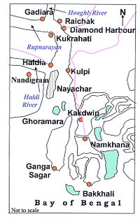
Earlier known as Hajipur, this charming place was named Diamond Harbour by the British. The place was considered a safe resting spot for ocean going ships and offered a spectacular view of the river. After the Rupnarayan River joins the Hughli, the river bends south and widens out to a form a huge expanse of water. A little further down, the Haldi river joins it.
In earlier days Diamond Harbour used to be a stronghold of Portuguese pirates. The ruins of the fort of Chingrikhali can still be seen. It is believed to be linked with the Portuguese but some opine that the East India Company built it before they could establish themselves in Kolkata. There is an old lighthouse nearby. Diamond Harbour is well connected with Kolkata by road and rail. The tourist lodge, Sagarika, located on the riverbank, has been popular for many years. It also has a number of private hotels. As Diamond Harbour is within easy reach of Kolkata, just around 50 km, it is generally a day out picnic spot for city dwellers.
Contents
Demographics
As of 2001[update] India census,[1] Diamond Harbour had a population of 37,238. Males constitute 51% of the population and females 49%. Diamond Harbour has an average literacy rate of 72%, higher than the national average of 59.5%: male literacy is 77% and, female literacy is 67%. In Diamond Harbour, 10% of the population is under 6 years of age.
Nearby places
This small town with a picturesque setting is the gateway to the south-western part of the district leading to such places as Gangasagar, Kakdwip, Namkhana and Bakkhali. Gangasagar is a popular pilgrimage centre where people go to have bath to wash their sins. Bakkhali is gaining in popularity as a beach resort. There is a five star hotel with a magnificent panoramic view of the river at Raichak. Jetties at Diamond Harbour, Raichak and Mirpur provide steamer service to the other bank of the wide river estuary. In future it is connected with Joka by Kolkata Metro Railway.
Port development
The area being in the proximity of the Bay of Bengal, there is scope for development of ports and shipping activity. The special economic zone at Falta is one of the eight such zones of the Government of India. It has container-handling jetty. The Government of West Bengal proposes to construct a minor port at Kulpi with facilities for handling containers.
As large ocean going ships with full load of goods cannot enter the river ports at Kolkata and Haldia, the need for a seaport in the area has been felt for a long time. Such a future port would obviously be located south of Diamond Harbour but would enhance the importance of the place as a base for the port. Raichak is also pretty near by.
Kolkata Port Trust is considering construction of cargo handling jetties at Diamond harbour.[2]
References
- ^ "Census of India 2001: Data from the 2001 Census, including cities, villages and towns (Provisional)". Census Commission of India. Archived from the original on 2004-06-16. http://web.archive.org/web/20040616075334/http://www.censusindia.net/results/town.php?stad=A&state5=999. Retrieved 2008-11-01.
- ^ The Statesman 1 October 2006
Cities and towns in South 24 Parganas district Alipore Sadar subdivision Alipore · Amtala · Balarampur · Birlapur · Bishnupur · Bowali · Budge Budge · Chak Enayetnagar · Chak Kashipur · Chata Kalikapur · Kanyanagar · Maheshtala · Pujali · Uttar RaypurBaruipur subdivision Diamond Harbour subdivision Kakdwip subdivision KakdwipCanning subdivision Related topics South 24 Parganas topics · People from South 24 Parganas district · Haliday Island Wildlife Sanctuary · Lothian Island Wildlife Sanctuary · Sajnakhali Wildlife Sanctuary · Sundarbans · Sundarban National ParkCities and towns
in other districtsBankura · Bardhaman · Birbhum · Cooch Behar · Dakshin Dinajpur · Darjeeling · Hooghly · Howrah · Jalpaiguri · Malda · Murshidabad · Nadia · North 24 Parganas · Paschim Medinipur · Purba Medinipur · Purulia · Uttar DinajpurSouth 24 Parganas district topics General Bonbibi · Gangaridai • Haliday Island Wildlife Sanctuary · Lothian Island Wildlife Sanctuary · Sajnakhali Wildlife Sanctuary · Sundarbans · Sundarban National Park · Tiger attacks in the Sundarbans · The Hungry TideSubdivisions Locations
other than cities and townsIslands Municipalities Baruipur • Budge Budge • Diamond Harbour • Jaynagar Mazilpur • Maheshtala • Pujali • Rajpur SonarpurCommunity development blocks Alipore Sadar subdivision Bishnupur I • Bishnupur II • Budge Budge I • Budge Budge II • Thakurpukur Mahestala Baruipur subdivision Baruipur • Bhangore I • Bhangore II • Jaynagar I • Jaynagar II • Kultali • Sonarpur Canning subdivision Basanti • Canning I • Canning II • Gosaba Diamond Harbour subdivision Diamond Harbour I • Diamond Harbour II • Falta • Kulpi • Magrahat I • Magrahat II • Mandirbazar • Mathurapur I • Mathurapur II Kakdwip subdivision Kakdwip • Namkhana • Patharpratima • SagarRivers Transport Lok Sabha constituencies Vidhan Sabha constituencies Gosaba • Basanti • Kultali • Patharpratima • Kakdwip • Sagar • Kulpi • Raidighi • Mandirbazar • Jaynagar • Baruipur Purba • Canning Paschim • Canning Purba • Baruipur Paschim • Magrahat Purba • Magrahat Paschim • Diamond Harbour • Falta • Satgachia • Bishnupur • Sonarpur Dakshin • Bhangar • Kasba • Jadavpur • Sonarpur Uttar • Tollyganj • Behala Purba • Behala Paschim • Maheshtala • Budge Budge • MetiaburuzFormer Vidhan Sabha constituencies Mathurapur • Garden Reach • Dhakuria • Kabitirtha • AliporeSee also Cities and towns in South 24 Parganas district · People from South 24 Parganas districtOther districts Bankura · Bardhaman · Birbhum · Cooch Behar · Dakshin Dinajpur · Darjeeling · Hooghly · Howrah · Jalpaiguri · Kolkata · Malda · Murshidabad · Nadia · North 24 Parganas · Paschim Medinipur · Purba Medinipur · Purulia · Uttar DinajpurMunicipalities & CD blocks of West Bengal Municipal
CorporationsMunicipalities Alipurduar · Arambagh · Ashoknagar Kalyangarh · Baduria · Baidyabati · Bally · Balurghat · Bangaon · Bankura · Bansberia · Baranagar · Barasat · Bardhaman · Barrackpore · Baruipur · Basirhat · Beldanga · Berhampore · Bhadreswar · Bhatpara · Bidhannagar · Birnagar · Bishnupur · Bolpur · Budge Budge · Chakdaha · Champdani · Chandrakona · Contai · Cooch Behar · Dainhat · Dalkhola · Darjeeling · Dhulian · Dhupguri · Diamond Harbour · Dinhata · Dubrajpur · Dum Dum · Egra · English Bazar · Gangarampur · Garulia · Gayespur · Ghatal · Gobardanga · Guskara · Habra · Haldia · Haldibari · Halisahar · Hugli-Chuchura · Islampur · Jalpaiguri · Jamuria · Jangipur · Jhalda · Jhargram · Jiaganj Azimganj · Jaynagar Mazilpur · Kaliaganj · Kalimpong · Kalna · Kalyani · Kamarhati · Kanchrapara · Kandi · Katwa · Kharagpur · Kharar · Khardaha · Kshirpai · Konnagar · Krishnanagar · Kulti · Kurseong · Madhyamgram · Maheshtala · Mal · Mathabhanga · Mekhliganj · Memari · Midnapore · Murshidabad · Nabadwip · Naihati · Nalhati · New Barrackpur · North Barrackpur · North Dumdum · Old Maldah · Panihati · Panskura · Pujali · Purulia · Raghunathpur · Raiganj · Rajarhat · Rajpur Sonarpur · Ramjibanpur · Rampurhat · Ranaghat · Raniganj · Rishra · Sainthia · Shantipur · Serampore · Sonamukhi · South Dumdum · Suri · Taki · Tamluk · Tarakeswar · Titagarh · Tufanganj · Uluberia · Uttarpara Kotrung
Community
development
blocks*A Alipuduar I · Alipurduar II · Amdanga · Amta I · Amta II · Andal · Arambagh · Arsha · Ausgram I · Ausgram II B Baduria · Bagdah · Baghmundi · Bagnan I · Bagnan II · Balagarh · Balarampur · Balurghat · Bally Jagachha · Bamangola · Bandwan · Bangaon · Bankura I · Bankura II · Barjora · Bansihari · Barabani · Barabazar · Barrackpore I · Barrackpore II · Barasat I · Barasat II · Baruipur · Basanti · Basirhat I · Basirhat II · Beldanga I · Beldanga II · Berhampore · Bhagawangola I · Bhagawangola II · Bhagabanpur I · Bhagabanpur II · Bhangore I · Bhangore II · Bharatpur I · Bharatpur II · Bhatar · Binpur I · Binpur II · Bishnupur, Bankura · Bishnupur I, South 24 Parganas · Bishnupur II, South 24 Parganas · Bolpur Sriniketan · Budge Budge I · Budge Budge II · Burdwan I · Burdwan II · Burwan C Canning I · Canning II · Chakdaha · Chanchal I · Chanchal II · Chandipur · Chanditala I · Chanditala II · Chapra · Chandrakona I · Chandrakona II · Chhatna · Chinsurah-Mogra · Chopra · Contai I · Contai II · Contai III · Cooch Behar I · Cooch Behar II D Darjeeling Pulbazar · Dantan I · Dantan II · Daspur I · Daspur II · Debra · Deganga · Diamond Harbour I · Diamond Harbour II · Deshapran · Dhaniakhali · Dhupguri · Dinhata I · Dinhata II · Domjur · Domkal · Dubrajpur E Egra I · Egra II · English Bazar F Falakata · Falta · Farakka · Faridpur-Durgapur G Gaighata · Galsi I · Galsi II · Gangajalghati · Gangarampur · Garhbeta I · Garhbeta II · Garhbeta III · Gazole · Ghatal · Goalpokhar I · Goalpokhar II · Goghat I · Goghat II · Gopiballavpur I · Gopiballavpur II · Gorubathan · Gosaba H Habibpur · Habra I · Habra II · Haldia · Haldibari · Hanskhali · Hariharpara · Haringhata · Haripal · Harirampur · Harishchandrapur I · Harishchandrapur II · Haroa · Hasnabad · Hemtabad · Hili · Hingalganj · Hirbandh · Hura I Ilambazar · Indas · Indpur · Islampur · Itahar J Jagatballavpur · Jalangi · Jalpaiguri · Jamalpur · Jamboni · Jamuria · Jangipara · Jaynagar I · Jaynagar II · Jhalda I · Jhalda II · Jhargram · Jorebunglow Sukhiapokhri · Joypur, Bankura · Joypur, Purulia · K Kakdwip · Kalchini · Kaliachak I · Kaliachak II · Kaliachak III · Kaliaganj · Kaliganj · Kalimpong I · Kalimpong II · Kalna I · Kalna II · Kandi · Kanksa · Karandighi · Karimpur I · Karimpur II · Kashipur · Katwa I · Katwa II · Keshiari · Keshpur · Ketugram I · Ketugram II · Khanakul I · Khanakul II · Khandaghosh · Kharagpur I · Kharagpur II · Khargram · Kharibari · Khatra · Khejuri I · Khejuri II · Khoyrasole · Kotulpur · Krishnaganj · Krishnanagar I · Krishnanagar II · Kulpi · Kultali · Kumarganj · Kumargram · Kurseong · Kushmandi L Labpur · Lalgola M Madarihat-Birpara · Magrahat I · Magrahat II · Mahisadal · Mal · Manbazar I · Manbazar II · Mandirbazar · Manikchak · Manteswar · Mathabhanga I · Mathabhanga II · Mathurapur I · Mathurapur II · Matiali · Matigara · Maynaguri · Mayureswar I · Mayureswar II · Mejia · Mekhliganj · Memari I · Memari II · Midnapore Sadar · Minakhan · Mirik · Mohammad Bazar · Mohanpur · Mongalkote · Moyna · Murarai I · Murarai II · Murshidabad-Jiaganj N Nabadwip · Nabagram · Nagrakata · Nakashipara · Nalhati I · Nalhati II · Namkhana · Nandakumar · Nandigram I · Nandigram II · Nanoor · Naoda · Narayangarh · Naxalbari · Nayagram · Neturia O Old Malda · Onda · P Panchla · Pandabeswar · Pandua · Panskura I · Panskura II · Para · Patashpur I · Patashpur II · Patharpratima · Patrasayer · Phansidewa · Pingla · Polba-Dadpur · Puncha · Purbasthali I · Purbasthali II · Pursurah · Purulia I · Purulia II R Raghunathganj I · Raghunathganj II · Raghunathpur I · Raghunathpur II · Raiganj · Raina I · Raina II · Raipur · Rajarhat · Rajganj · Rajnagar · Ramnagar I · Ramnagar II · Rampurhat I · Rampurhat II · Ranaghat I · Ranaghat II · Rangli Rangliot · Ranibandh · Raniganj · Raninagar I · Raninagar II · Ratua I · Ratua II S Sabang · Sagar · Sagardighi · Sahid Matangini · Sainthia · Salanpur · Salboni · Saltora · Samserganj · Sandeshkhali I · Sandeshkhali II · Sankrail, Howrah · Sankrail, Paschim Medinipur · Santipur · Santuri · Sarenga · Shyampur I · Shyampur II · Simlapal · Singur · Sitai · Sitalkuchi · Sonamukhi · Sonarpur · Sreerampur-Uttarpara · Suri I · Suri II · Sutahata · Suti I · Suti II · Swarupnagar T Taldangra · Tamluk · Tapan · Tarakeswar · Tehatta I · Tehatta II · Thakurpukur Mahestala · Tufanganj I · Tufanganj II U Udaynarayanpur · Uluberia I · Uluberia II
- Similar to Tehsils in many states of India
Categories:- Kolkata
- Ports and harbours of West Bengal
- Forts in West Bengal
- Cities and towns in South 24 Parganas district
- Police stations in South 24 Parganas district


Wikimedia Foundation. 2010.