- Marmion, Western Australia
-
Marmion
Perth, Western Australia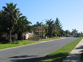
 Marmion
Population: 2,106 (2006 census)[1] Established: 1970s Postcode: 6020 Area: 1.2 km² (0.5 sq mi) Location: 17 km (11 mi) NW of Perth LGA: City of Joondalup State District: Carine Federal Division: Moore Suburbs around Marmion: Sorrento Duncraig Indian Ocean Marmion Duncraig Watermans Bay Carine Coordinates: 31°50′24″S 115°45′22″E / 31.840°S 115.756°E
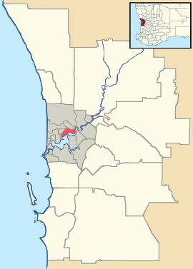
Marmion is a northern coastal suburb of Perth, the capital city of Western Australia. Its Local Government Area is the City of Joondalup.
Contents
History
Marmion was named after Patrick Marmion, master whaler, who operated a whaling station in the area in 1849. There are still some remains of the old whaling station in the adjacent suburb, Sorrento.[2] A monument to Marmion can be found in Geneff Park in Padbury Circle, Sorrento.
Prior to white settlement, the Whadjuk Aboriginal people, who called the area Mooro, gathered abalone and other shellfish in large numbers off the nearby reefs.
The area was popular with fishermen in the 1930s, and numerous boatsheds and shacks were built there, as well as a whaling station. A townsite was gazetted in the area in 1940,[3] but it remained largely undeveloped until the late 1950s, when the Postal District of Marmion was approved. At first, the only development in the area was the primary school, opened in 1956 as a two-teacher school and nicknamed "The Little School in the Bush", accessible only by a track until the mid-1970s. By 1961, the area west of Cliff Street was largely developed, and the Marmion Angling and Aquatic Club had been established. The rest of the suburb was developed between 1973 and 1976.
Geography
Marmion is bounded by Marine Terrace to the north, Marmion Avenue to the east, the Beach Road coastal segment to the south and West Coast Drive and the ocean to the west.[4]
At the ABS 2006 census, Marmion had a population of 2,106 people living in 736 dwellings.[1]
 Marmion Village shopping centre.
Facilities
Marmion is a residential suburb, relying on the Marmion Village shopping centre in Sheppard Way for basic commercial services, and Karrinyup Shopping Centre and Centro Warwick for other services. The suburb is served by the Marmion Primary School and falls within Carine Senior High School's catchment area. Braden Park, a large park with play equipment and lighting, is situated near the shopping centre.[4]
The Marmion Angling and Aquatic Club is a boating and fishing club located above Marmion Beach, which has a function room overlooking the Indian Ocean. Off the coast is the Marmion Marine Park,[5] which provides a home for many species of marine animals.
Transport
Marmion's west is served by the Transperth 423 bus route between Warwick and Stirling,[6] while the 441 bus along Marmion Avenue,[7] serves the eastern part of the suburb. All bus services are operated by Path Transit.
Politics
Marmion is a reasonably affluent suburb with a large elderly population. It consistently supports the Liberal Party at both federal and state elections.
Education
Marmion has one state public school, Marmion Primary School,which caters for kindergarten through to year 7.
References
- ^ a b Australian Bureau of Statistics (25 October 2007). "Marmion (State Suburb)". 2006 Census QuickStats. http://www.censusdata.abs.gov.au/ABSNavigation/prenav/LocationSearch?collection=Census&period=2006&areacode=SSC51896&producttype=QuickStats&breadcrumb=PL&action=401. Retrieved 2008-10-05.
- ^ Western Australian Land Information Authority. "History of metropolitan suburb names". http://www.landgate.wa.gov.au/corporate.nsf/web/History+of+metropolitan+suburb+names. Retrieved 2007-01-17. Incorrectly references Peter Marmion.
- ^ "New Townsite - Marmion (per 940/36)". Western Australia Government Gazette: p. 1940:474. 5 April 1940.
- ^ a b Department of Land Information. StreetSmart® Perth Street Directory (50 (2009) ed.). West Australian Newspapers Ltd. pp. Map 280. ISBN 978-1-921048-28-9.
- ^ Conservation & Land Management (WA) (20 September 2005). "Marmion Marine Park". Archived from the original on 2006-09-19. http://web.archive.org/web/20060919075044/http://www.naturebase.net/national_parks/marmion.html. Retrieved 2007-01-17.
- ^ Northern 62 timetable, Transperth, effective 8 August 2005. Accessed 17 January 2007.
- ^ Northern 63 timetable, Transperth, effective 1 October 2006. Accessed 17 January 2007.
Suburbs of the City of Joondalup | Perth | Western Australia North Burns Beach · Connolly · Currambine · Edgewater · Heathridge · Iluka · Joondalup · Kinross · Ocean Reef
South ¹ Suburb shared with other Local Government AreasCategories:- Suburbs of Perth, Western Australia


Wikimedia Foundation. 2010.