- Curl Curl, New South Wales
-
For the ferry Curl Curl, see Dee Why ferry.
Curl Curl
Sydney, New South Wales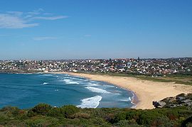
Curl Curl Beach viewed from the northPopulation: 2,116[1] Postcode: 2096 Location: 18 km (11 mi) north-east of Sydney CBD LGA: Warringah Council State District: Manly Federal Division: Warringah Suburbs around Curl Curl: Wingala North Curl Curl Brookvale Curl Curl Tasman Sea North Manly Freshwater Curl Curl is a suburb of northern Sydney in the state of New South Wales, Australia. Curl Curl is located 18 kilometres north-east of the Sydney central business district, in the local government area of Warringah Council and is part of the Northern Beaches region. Curl Curl is colloquially known as "Curly".
Contents
Location
Curl Curl Lagoon and Greendale Creek, separate Curl Curl from North Curl Curl.[2] Neighbouring suburbs include Freshwater, Brookvale and Dee Why. Wingala is an adjacent locality. Curl Curl Beach runs along the eastern border and extends to North Curl Curl Beach.
Beach
The stretch of beach at Curl Curl is divided into North and South Curl Curl beaches. Curl Curl is known for some of the best surfing on the Northern Beaches.
Curl Curl Beach has two volunteer surf lifesaving clubs, South Curl Curl SLSC established in 1918 and North Curl Curl SLSC established in 1922. Warringah Council employs professional lifeguards to patrol this beach during the summer months. There are saltwater rockpools at each end of the beach.
History
The name Curl Curl appears to be the original Aboriginal name for the larger area of Manly Vale, Freshwater, Queenscliff. The name Curl Curl may have been derived from the Aboriginal phrase curial curial, meaning river of life.[3]
The name Curl Curl Lagoon was originally applied to Manly Lagoon, which empties into the ocean at Queenscliff. The lagoon that empties into the ocean at Curl Curl Beach was named Harbord Lagoon until it was renamed Curl Curl Lagoon as part of a renaming program in the 1980s.[4] Manly Creek was originally named Curl Curl Creek and Queenscliff Headland was called Curl Curl Headland.
In 1858 Samuel Bennett paid £600 for an 80-acre (320,000 m2) property, in the Curl Curl/Brookvale area south of Greendale Creek and was farmed by Bennett up until the mid 1870s.[5] This area was later known as Brighton Estate.
Sport and recreation
Parks and playing fields are located on either side of Curl Curl Lagoon and Greendale Creek. These areas were originally low-lying swampy land that was reclaimed by dumping rubbish on both sides of the lagoon throughout the 1950s and 1960s.[6][7]
Curl Curl Youth Club has organised football and netball for 50 years.[8]
Curl Curl Amateur Swimming Club runs regular Saturday afternoon swim events during the spring and summer months at the South Curl Curl rock pool. The club commenced in 1966 and has been running swimming events every year for swimmers of all ages and abilities ranging from learners to competitive athletes.[9]
1st/2nd Harbord Scouts meet at the scout hut, 43 Stirgess Ave. Harbord Bowling & Recreation Club has four greens and regularly holds world-class tournaments.
Public transport
Curl Curl is serviced by 4 bus routes 136: Manly to Chatswood; 139: Manly to Warringah Mall; E65: South Curl Curl to Sydney CBD. Also the 159 Manly to Dee Why.
Schools
Freshwater Senior Campus which is part of Northern Beaches Secondary College is for year 11 and 12 students, located on the corner of Harbord Road and Brighton Street, Curl Curl.
Stewart House is located across the road from South Curl Curl beach and provides students with an opportunity for a break from their current circumstances. Over the years, more than 150,000 children have benefited from a stay at Stewart House.[10]
Curl Curl North Public School is a primary school located at Playfair Road near Abbot Road.
References
- ^ Australian Bureau of Statistics (25 October 2007). "Curl Curl (State Suburb)". 2006 Census QuickStats. http://www.censusdata.abs.gov.au/ABSNavigation/prenav/LocationSearch?collection=Census&period=2006&areacode=SSC11273&producttype=QuickStats&breadcrumb=PL&action=401. Retrieved 2007-07-01.
- ^ "NSW Department of Natural Resources Estuaries". NSW Department of Natural Resources. http://naturalresources.nsw.gov.au/estuaries/inventory/curlcurl.shtml. Retrieved 2007-11-08.
- ^ "Geographical names register extract: Curl Curl". Geographical Names Board of New South Wales. http://www.gnb.nsw.gov.au/name_search/extract?id=JPYbBKsySX. Retrieved 2007-09-10.
- ^ "Manly Daily article". Cumberland newspapers. http://www.manlydaily.com.au/article/2007/12/08/7740_news_feature.html. Retrieved 2007-12-10.
- ^ The Bennetts of 19th Century Manly By Jennifer Grant Jary, February 2007
- ^ "NSW Parliament Hansard Papers". NSW Parliament. http://www.parliament.nsw.gov.au/prod/PARLMENT/hansArt.nsf/V3Key/LC19940511041. Retrieved 2007-09-11.
- ^ "ADOPTION OF DEE WHY AND CURL CURL LAGOON FLOOD STUDY, FLOODPLAIN RISK MANAGEMENT STUDY AND FLOODPLAIN RISK MANAGEMENT PLAN". Warringah Council. http://www.warringah.nsw.gov.au/council_then/documents/2006022896.pdf. Retrieved 2007-11-08.
- ^ [1] www.curlcurlyouthclub.com.au[
- ^ [2] www.curlcurlswimming.org.au
- ^ [3] www.stewarthouse.org.au
External links
- Curl Curl, New South Wales is at coordinates 33°46′20″S 151°17′24″E / 33.77213°S 151.28992°ECoordinates: 33°46′20″S 151°17′24″E / 33.77213°S 151.28992°E
- North Curl Curl SLSC
- North Curl Curl Rockpool
- South Curl Curl SLSC
- South Curl Curl Rockpool
- Harbord Bowling Club, Curl Curl
- Freshwater Campus, Curl Curl
- Curl Curl Youth Club
- Curl Curl Amateur Swimming Club
- Brookvale - Curl Curl Scout Group
Suburbs of Warringah Council | Northern Beaches | Sydney Allambie Heights · Beacon Hill · Belrose · Brookvale · Collaroy · Collaroy Plateau · Cottage Point · Cromer · Curl Curl · Davidson · Dee Why · Duffys Forest · Forestville · Frenchs Forest · Freshwater · Ingleside · Killarney Heights · Manly Vale · Narrabeen · Narraweena · North Balgowlah · North Curl Curl · North Manly · Oxford Falls · Queenscliff · Terrey Hills · Wheeler HeightsList of Sydney suburbs Categories:- Suburbs of Sydney
- Double-named places in Australia
- Australian Aboriginal placenames
- Beaches of New South Wales
- Surfing locations in New South Wales

Wikimedia Foundation. 2010.