- South Gosforth Metro station
-
South Gosforth 
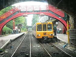
The red footbridge at South Gosforth was saved when the original 1864 station was demolished to make way for the Metro Control Centre - the building overhanging platform 2. Location Place Gosforth Local authority Newcastle Fare zone information Network One zone 1 & 2 Metro zone A & B Original (1979) zone 17 Station code SGF Operations Platforms 2 History Opened 1864-06-27 Metro since 1980-08-11 Tyne and Wear Metro
List of Tyne and Wear Metro stationsSouth Gosforth Metro station is located in a suburb of Newcastle upon Tyne in England. It is a busy interchange station on the Tyne and Wear Metro where many passengers change between Green line services to/from the Airport and Yellow line services to/from the Coast. During peak periods the station sees an intensive service with trains operating up to every 3 minutes to and from Newcastle city centre.
The station also houses the Metro Control Centre, located on platform 2 and on the site of the former station buildings.
Contents
History
The station was originally opened in 1864 as Gosforth station and was later renamed to South Gosforth in 1905. This was due to the opening of the West Gosforth station, located near to the modern Regent Centre.[1] An original North Eastern Railway footbridge remains in use at South Gosforth. A similar footbridge removed from Percy Main station has been preserved by the National Railway Museum in York.[2]
South Gosforth Depot
The Metro rolling stock depot is located close by, in the triangle of land between South Gosforth, Regent Centre and Longbenton stations. The depot is surrounded by a small industrial estate that mainly houses production facilities for the Greggs food chain. A number of Metro services terminate at South Gosforth, particularly at the end of rush hour and close of service, due to its proximity to the depot.
Usage
The station was used by 1.15 million passengers in the period 2008/2009.[3]
References
- ^ "Blyth & Tyne railway". Northumbrian Railways. http://www.northumbrian-railways.co.uk/index.php?page=blyth-tyne-branch. Retrieved 2009-03-17.
- ^ "Large exhibits". NRM Collections. National Railway Museum. http://www.nrm.org.uk/OurCollection/BuildingTheRailway.aspx. Retrieved 2007-02-10.
- ^ NEXUS Business Intelligence Report. http://www.nexus.org.uk/wps/wcm/resources/file/eba01f018731343/Business%20Intelligence%20Annual%20Report%20200809.pdf
External links
- Train times and station information for South Gosforth Metro station from Nexus
Coordinates: 55°00′22″N 1°36′29″W / 55.006°N 1.608°W
Preceding station Tyne and Wear Metro Following station towards St James via the CoastYellow line towards South Shieldstowards AirportGreen line towards South HyltonEast Coast Main Line (London Kings Cross) → → Birtley (closed) • Lamesley (closed) • Low Fell (closed) • Bensham (closed) • Newcastle Central • Manors • Heaton (closed) • Forest Hall (closed) • Killingworth (closed) • Annitsford (closed) → →(Edinburgh Waverley)Durham Coast Line Tyne Valley Line Former railway linesBlyth and Tyne Railway Backworth • Benton • Cullercoats • Gosforth • Holywell • Jesmond • Moor Edge • New Bridge Street • North Shields • Percy Main • Prospect Hill • Tynemouth • Whitley BayDerwent Valley Railway Swalwell • Rowlands Gill → → (Blackhill)Newcastle and Carlisle Railway
(Original route)North Wylam loop Lemington • Newburn • Heddon on the Wall • North WylamPonteland Light Railway Gosforth • West Gosforth • Coxlodge • Kenton • Callerton → → (Ponteland)Riverside branch Byker • St Peter's (Tyneside) • St Anthony's • Walker • Carville • Point Pleasant • Willington QuayTanfield Railway Sunniside → → (East Tanfield)Metro (converted stations) Benton • Brockley Whins • Cullercoats • East Boldon • Felling • Hebburn • Howdon • Jarrow • Longbenton • Monkseaton • North Shields • Percy Main • Seaburn • South Gosforth • Sunderland • Tynemouth • Walkergate • Wallsend • West Jesmond • West Monkseaton • Whitley Bay •Metro (purpose built stations) Airport • Bank Foot • Bede • Byker • Callerton Parkway • Central Station • Chichester • Chillingham Road • Fawdon • Fellgate • Four Lane Ends • Gateshead • Gateshead Stadium • Hadrian Road • Haymarket • Heworth • Ilford Road • Jesmond Metro station • Kingston Park • Manors • Meadow Well • Millfield • Monument • Northumberland Park • Pallion • Palmersville • Park Lane • Pelaw • Regent Centre • Simonside • St James • St Peter's (Wearside) • Shiremoor • South Hylton • South Shields • Stadium of Light • Tyne Dock • University (Sunderland) • Wansbeck Road •
This United Kingdom rapid transit article is a stub. You can help Wikipedia by expanding it.
