- Clifton Rocks Railway
-
Lower Station, Clifton Rocks Railway 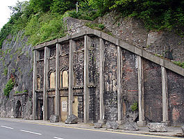
Clifton Rocks Railway lower station Location Place Hotwells Area Bristol Operations Post-grouping Clifton Rocks Railway Platforms 4 History 11 March 1893 Opened 1 October 1934 Closed Disused railway stations in the United Kingdom Closed railway stations in Britain
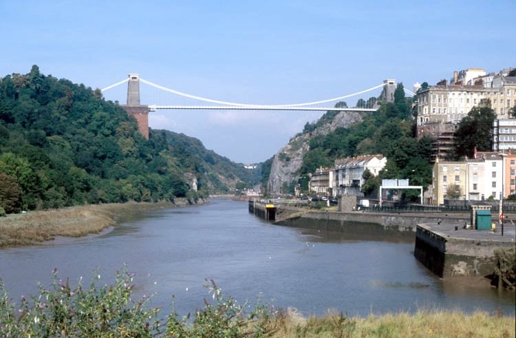
A B C D–F G H–J K–L M–O P–R S T–V W–Z The Avon Gorge. The Clifton Rocks Railway ran from a lower station just beyond the furthest buildings at river level, through a tunnel to an upper station at bridge level.
The Clifton Rocks Railway was an underground funicular railway in Bristol, linking Clifton at the top to Hotwells and Bristol Harbour at the bottom of the Avon Gorge in a tunnel cut through the limestone cliffs. The upper station is close to Brunel's famous Clifton Suspension Bridge and is located adjacent to the former Grand Spa Hotel (now the Avon Gorge Hotel). The lower station was opposite the paddle steamer landing ferries in Hotwells, Hotwells railway station of the Bristol Port Railway and Pier, a terminus of Bristol Tramways and the Rownham ferry enabling connections across the river Avon.
Contents
History
Construction of the railway was funded by the publisher George Newnes, also proprietor of the Lynton and Lynmouth Cliff Railway, and as at Lynton and Lynmouth the engineer was George Croydon Marks. It opened on 11 March 1893, but was never a great success; in 1912 it was sold to Bristol Tramways, but it continued to struggle and closed on 1 October 1934.[1]
The railway had a length of 450 feet (137 m), overcoming a vertical distance of 200 feet (61 m) at a gradient of about 1 in 2.2 (45%). There were four cars in two connected pairs, essentially forming two parallel funicular railways, each running on 38 inch (965 mm) narrow gauge tracks. The system was operated by gravity, with water ballast being let into the cars at the top station and out at the bottom, and an oil- or gas-burning pump returning the water to the top of the system.[2]
During the Second World War blast walls were installed in the tunnel, which was used as offices by BOAC, as a relay station by the BBC (who also constructed an emergency studio there, though it was never put into use), and as an air-raid shelter. The BBC continued to use parts of the tunnel until 1960.[1][3]
Preservation
A voluntary group has now been formed to preserve and restore the railway. They hope to raise funds for a feasibility study into the complete restoration of the railway. The cost of complete restoration is estimated at around £15 million.[4]
References
- ^ a b "Clifton Rocks Railway - History". Subterranea Britannica. http://www.cliftonrocksrailway.org.uk/history_06.htm. Retrieved 3 June 2007.
- ^ "Clifton Rocks Railway - FAQ". Clifton Rocks Railway special interest group. http://www.cliftonrocksrailway.org.uk/faqs_06.htm. Retrieved 3 June 2007.
- ^ "The Clifton Rocks Railway Tunnel". Old Radio Broadcast Equipment and Memories. http://www.roger.beckwith.btinternet.co.uk/bh/clifton/clifton.htm. Retrieved 3 June 2007.
- ^ "Clifton Rocks Railway - About Us". Clifton Rocks Railway special interest group. http://www.cliftonrocksrailway.org.uk/about_06.htm. Retrieved 3 June 2007.
External links
- Clifton Rocks Railway website
- Clifton Rocks Railway refurbishment
- World War II BBC Studios, clip by BBC Points West
Coordinates: 51°27′14.4″N 2°37′31.7″W / 51.454°N 2.625472°W
Categories:- Funicular railways in the United Kingdom
- Underground railways
- History of Bristol
- Rail transport in Bristol
- Bristol Harbourside
- Railway lines opened in 1893
- Railway companies disestablished in 1934
- Works by George Croydon Marks
- Defunct funicular railways
- 3ft 3in gauge railways
- Clifton, Bristol

Wikimedia Foundation. 2010.