- Mawson Lakes, South Australia
-
Mawson Lakes
Adelaide, South Australia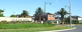
Entrance to the CascadePopulation: 5,246 2006 Census [1] Established: 1990s Postcode: 5095 [2] Area: 6.37 km² (2.5 sq mi) Location: 12 km (7 mi) from Adelaide LGA: City of Salisbury State District: Port Adelaide Federal Division: Port Adelaide Suburbs around Mawson Lakes: Green Fields Parafield Gardens Para Hills West Dry Creek Mawson Lakes Ingle Farm Cavan Pooraka Ingle Farm Mawson Lakes is a suburb and new residential development in the City of Salisbury, Adelaide, with the first land being released in 1998. It has a census area population of 5,246 people. The suburb is located in the northern suburbs of Adelaide around 12 km north of the Central business district. Much of the suburb was previously known as The Levels, and was a non-residential area, housing a campus of the University of South Australia and Technology Park Adelaide.
Contents
History
The residential development grew out of the South Australian Government's plans for a Multifunction Polis (or MFP), which was designed to be a modern high-tech community of the future. After the plans for the MFP fell out of favour, the site was taken on by the property developer Delfin (now Delfin Lend Lease).
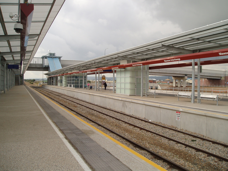
Today, it includes Technology Park, the Mawson Lakes campus of the University of South Australia, Endeavour College, as well as growing residential and commercial zones. It also contains the public transport hub Mawson Interchange, which is expected to become one of the five busiest stations in Adelaide.
The area now occupied by Mawson Lakes was formerly The Levels.
Technology Park Adelaide
Technology Park Adelaide is Australia's first technology park, having been established in 1982 by the Government of South Australia. It is currently[when?] owned and managed by the Government of South Australia's Land Management Corporation.
The Technology Park Adelaide is a 65 hectare site which allows any organisation with a technological focus to locate there. Over 90 organisations are located at the Park, with the majority of these organisations having a defence focus. The main types of organisations at the Park are classified as Small to Medium Enterprises (SME) however large corporate organisations have a presence in the Park, including BAE Systems, Saab Systems, Topcon, Optus, Xtralis, and Raytheon.
The Park is located adjacent to the Mawson Lakes project, which is a joint venture between the Land Management Corporation and Delfin Lend Lease.
Residents
 Construction of housing is ongoing
According to the 2006 Census the population of the Mawson Lakes census area was 5,246 people. Approximately 50.5% of the population were male, 62.6% are Australian born, over 83.1% of residents are Australian citizens and only 0.3% were native born indigenous people. Mawson Lakes has an educated population with over 45% of the population holding a degree, diploma or vocational qualification. This level of education attainment is reflected in the suburb's employment patterns: the most popular industries for employment were Manufacturing (16.9%), Retail Trades (11.9%) and Public Service (10.3%), while the unemployment rate is approx. 2.9%. The median weekly household income is A$1,433 or more per week, compared with $924 in Adelaide overall. 22.3% of the population identify themselves as Catholic, while a slightly higher 24.2% identify with no religion at all.[3]
Transport
 Mawson Interchange
Cars are the preferred mode of transport in the suburb. According to the Australian Bureau of Statistics 73.9% of residents are drivers or passengers of cars for their commute to work. Mawson Lakes is connected to the major Adelaide thoroughfares of Main North Road, Salisbury Highway and Port Wakefield Road. Adelaide's city centre can typically be reached by car in 30 minutes.
Because the area is mainly residential only a small proportion (2%) walk to work while a slightly smaller number (0.8%) use a bicycle. Although there are good connections to Adelaide's public transport network, only 3.9% take the bus to work, while a smaller 3.6% of people use the train. Bus routes connect Mawson Lakes to the Central business district as well as Salisbury, Elizabeth and Modbury. Mawson Interchange, built in 2005, is located on the Gawler Central commuter railway line. Services are high frequency, with 15 minute services to the City and Gawler. Services run more frequently in peak hours, half hourly on weekends and hourly at night. The interchange also has various bus connections.
Also see Transport in Adelaide
Water supply
Mawson Lakes features a dual water supply system, supplying drinking water and recycled water to homes via completely separate mains. The recycled water is sourced from the Bolivar Sewage Treatment plant approximately 8 km away and then has stormwater added to it from the Salisbury wetlands before it is treated to Class A standard recycled water for use on gardens, reserves and connected to the toilet of each residence in Mawson Lakes. SA Water provides a comprehensive audit of homes within the area to ensure that cross connection between the recycled water and drinking water does not occur.[4] Guidelines for the use of recycled water are published by the South Australian Environment Protection Authority (EPA).
Mawson Central
The central commercial area of Mawson Lakes, situated between Main Street and Garden Terrace, and north of the Promenade is rapidly growing to become a major shopping precinct with a hotel, florist (Flowers Everywhere), two restaurants, three cafes, medical centre, real estate, bargain shop, and Woolworths.
Politics
2007 Federal Election [5] Liberal 44.26% Labor 43.30% Greens 5.63% Family First 5.41% Democrats 1.40% 2006 State Election [6] Labor 55.2% Liberal 28.7% Family First 8.1% Greens 3.9% Democrats 2.3% Mawson Lakes is a part of the federal division of Port Adelaide, which has been represented by new Labor MP, Mark Butler since 2007, and is a part of the state electoral district of Port Adelaide, which has been represented by Labor Minister and former Deputy Premier Kevin Foley since 2002.
Results shown here are taken from the Mawson Lakes booth for both seats. Although a part of the division of Port Adelaide which is said to be a 'working class' seat and therefore safe-Labor, Mawson Lakes has a higher number of conservative voters, which explains why the Liberal Party received more first preference votes at this location at the last federal election. Labor went on to win the seat as a whole.
Sporting teams
Mawson Lakes is home to the Mawson Lakes Football Club, the only football club in the area, the Palms Golf Club, and the Mawson Lakes Cricket Club, formerly Elders-UniSA Cricket Club and have played in the area since 1952.
See also
References
- ^ Australian Bureau of Statistics (25 October 2007). "Mawson Lakes (State Suburb)". 2006 Census QuickStats. http://www.censusdata.abs.gov.au/ABSNavigation/prenav/LocationSearch?collection=Census&period=2006&areacode=SSC42021&producttype=QuickStats&breadcrumb=PL&action=401. Retrieved 2008-06-24.
- ^ Australia Post - Postcode: Mawson Lakes, SA (24 June 2008)
- ^ City of Salisbury Community Profile. Retrieved on 24 June 2008.
- ^ SA Water website, under search term "Mawson Lakes".
- ^ Mawson Lakes Polling Booth, Division of Port Adelaide, House of Representatives Division First Preferences, 2007 Federal Election. Retrieved on 24 June 2008.
- ^ SA 2006 election results and outcomes (PDF), (a) P.14 (d) P.13, State Electoral Office, South Australia, 2006. Retrieved on 24 June 2008.
External links
- mawsonlakescommunity.com.au - Delfin's Mawson Lakes Community Website
- community.mawsonlakes.org - MawsonLakes.Org Community Website (non-commercial)
Coordinates: 34°48′50″S 138°36′43″E / 34.814°S 138.612°E
Suburbs of the City of Salisbury Bolivar · Brahma Lodge · Burton · Cavan · Direk · Dry Creek · Edinburgh · Elizabeth Vale · Globe Derby Park · Green Fields · Gulfview Heights · Ingle Farm · Mawson Lakes · Para Hills · Para Hills West · Para Vista · Parafield · Parafield Gardens · Paralowie · Pooraka · Salisbury · Salisbury Downs · Salisbury East · Salisbury Heights · Salisbury North · Salisbury Park · Salisbury Plain · Salisbury South · St Kilda · Valley View · Walkley Heights · Waterloo CornerCategories:- Suburbs of Adelaide


Wikimedia Foundation. 2010.