California State Route 146
- California State Route 146
Infobox road
state=CA
type=SR
route=146
section=446
maint=Caltrans
length_mi=13
length_round=0
length_ref= [ [http://www.dot.ca.gov/hq/structur/strmaint/brlog2.htm January 1, 2006 California Log of Bridges on State Highways] ]
direction_a=West
terminus_a=jct|state=CA|US|101 near Soledad
junction=Pinnacles (break in route)
direction_b=East
terminus_b=jct|state=CA|SR|25 near Paicines
previous_type=SR
previous_route=145
next_type=SR
next_route=147
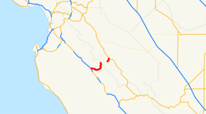
State Route 146 is a state highway in Monterey and San Benito Counties in Central California. The route serves as an entryway to the Pinnacles National Monument, located in the Gabilan Mountains, from both the Salinas Valley on the west and State Route 25 on the east.
This route is eligible for the State Scenic Highway System[ [http://www.leginfo.ca.gov/cgi-bin/displaycode?section=shc&group=00001-01000&file=260-284 CA Codes (shc:260-284)] ] .]Route description
Route 146 is divided into two sections and does not provide a continuous vehicular route through the monument. The western part of Route 146 passes from U.S. Route 101 near Soledad along "Metz Road" and "Shirttail Canyon Road" to the west area of Pinnacles. The eastern portion runs into the east area of Pinnacles from Route 25 along "Pinnacles Road".
Highway 146 has the distinction of following the San Andreas Fault line for much of its length. As it does, it straddles two separate land masses: the Pacific Plate and the North American Plate.
According to the National Park Service, Pinnacles has been administered as a wilderness area as long as that unit has been under their jurisdiction, and NPS sources contacted during research cannot recall any time when Route 146 proceeded through the park unbroken.
External links
* [http://www.dot.ca.gov/hq/roadinfo/sr146 Caltrans: Route 146 highway conditions]
* [http://www.cahighways.org/145-152.html#146 California Highways: Route 146]
References
Wikimedia Foundation.
2010.
Look at other dictionaries:
California State Route 127 — Karte … Deutsch Wikipedia
California State Route 78 — State Route 78 State Route 78 highlighted in red … Wikipedia
California State Route 127 — State Route 127 Death Valley Road … Wikipedia
California State Route 20 — Infobox road state=CA type=SR route=20 section=320 maint=Caltrans history=State highway in 1910 19; numbered in 1934 length mi=211.882 length round=3 length ref= length notes=(plus about 15.5 mi (25 km) on US 101) direction a=West terminus… … Wikipedia
California State Route 145 — Infobox road state=CA type=SR route=145 section=445 maint=Caltrans length mi=67 length round=0 length ref= [ [http://www.dot.ca.gov/hq/structur/strmaint/brlog2.htm January 1, 2006 California Log of Bridges on State Highways] ] direction a=South… … Wikipedia
California State Route 25 — Infobox road state=CA type=SR route=25 section=325 maint=Caltrans length mi=74 length ref= [ [http://www.dot.ca.gov/hq/structur/strmaint/brlog2.htm January 1, 2006 California Log of Bridges on State Highways] ] length round=0 direction a=South… … Wikipedia
California State Route 147 — Infobox road state=CA type=SR route=147 section=447 maint=Caltrans length mi=12 length ref= [ [http://www.dot.ca.gov/hq/structur/strmaint/brlog2.htm January 1, 2006 California Log of Bridges on State Highways] ] established= direction a=South… … Wikipedia
California State Route 96 — Infobox road state=CA type=SR route=96 section=396 maint= length mi=146.519 length round=3 length ref= direction a=West terminus a=Jct|state=CA|SR|299 at Willow Creek direction b=East terminus b=Jct|state=CA|I|5 near Yreka previous type=US… … Wikipedia
State Scenic Highway System (California) — infobox road state=CA marker highway name=State Scenic Highway SystemThe State Scenic Highway System is a list of highways, mainly state highways, that have been designated by the California Department of Transportation (Caltrans) as scenic… … Wikipedia
California County Routes in zone G — There are 21 routes assigned to the G zone of the California Route Marker Program, which designates county routes in California. The G zone includes county highways lying in the counties of Monterey, San Benito, San Luis Obispo, Santa Clara, and… … Wikipedia
