- Kirkby-in-Furness
-
Coordinates: 54°13′52″N 3°11′13″W / 54.231°N 3.187°W
Kirkby in Furness 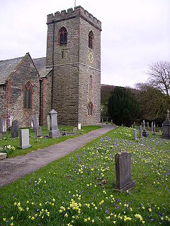
St Cuthberts Church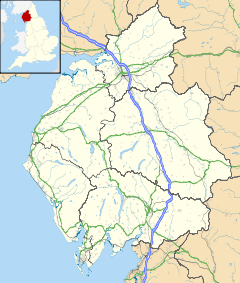
 Kirkby in Furness
Kirkby in Furness shown within CumbriaOS grid reference SD2282 Parish Kirby Ireleth District South Lakeland Shire county Cumbria Region North West Country England Sovereign state United Kingdom Post town KIRKBY IN FURNESS Postcode district LA17 Dialling code 01229 Police Cumbria Fire Cumbria Ambulance North West EU Parliament North West England UK Parliament Barrow and Furness List of places: UK • England • Cumbria Kirkby-in-Furness is a village in the Furness area of Cumbria, England. It is about 5 km south of Broughton in Furness and 8 km northwest of Ulverston. It is one of the largest villages on the peninsula's north-western coast, looking out over the Duddon estuary and the mountains of the Lake District. Its borders are the biggest for a village in the UK.[citation needed]
Kirkby is an agglomeration of six different hamlets, namely: Soutergate, Wall End, Beck Side, Sand Side, Marshside and Chapels. The name Kirkby was used by the Furness Railway company during the construction of its Cumbrian Coast Line, and was the name they gave to the station which serves these hamlets. The name Kirkby is much older; the parish of Kirkby Ireleth is listed in the Domesday Book and is of Norse origin. Kirkby Ireleth is mentioned in the Domesday Book as one of the townships forming the Manor of Hougun held by Earl Tostig.[1]
 Barnet Burns, was born here in 1805
Much of the housing and infrastructure in Kirkby arose due to the growth and development of the Burlington Slate Quarries, which are owned by the Cavendish family of Holker Hall and Chatsworth House in Derbyshire. Houses at Marshside and Incline Foot were originally built for quarry workers, and the railway linked up to the quarries following bogie lines. Present-day Kirkby-in-Furness is now primarily a commuter village but still provides a work force for the slate and agrarian work. The nearby Kirkby Moor rises to 334 m (1098 ft) above sea level which features a 12 turbine wind farm.
The village has an increasingly aged population due to the rise in house prices and lack of homes suitable for first time buyers. This has led to young families leaving Kirkby, buying cheaper houses in surrounding towns and villages. As a result the intake for the local primary school has fallen dramatically in the last few years, and continues to fall. The local football team, Kirkby United, are currently playing in the Furness Premier League.
References
See also
External links
 Media related to Kirkby-in-Furness at Wikimedia Commons
Ceremonial county of Cumbria Boroughs or districts Major settlements - Alston
- Ambleside
- Appleby-in-Westmorland
- Aspatria
- Barrow-in-Furness
- Bowness-on-Windermere
- Brampton
- Broughton-in-Furness
- Carlisle
- Cleator Moor
- Cockermouth
- Dalton-in-Furness
- Egremont
- Grange-over-Sands
- Harrington
- Kendal
- Keswick
- Kirkby Lonsdale
- Kirkby Stephen
- Longtown
- Maryport
- Millom
- Penrith
- Sedbergh
- Silloth
- Ulverston
- Whitehaven
- Wigton
- Windermere
- Workington
See also: List of civil parishes in Cumbria
Topics Categories:- Cumbria geography stubs
- Villages in Cumbria
- Furness
- Populated coastal places in Cumbria


Wikimedia Foundation. 2010.