Maupiti

Maupiti

Coordinates: 16°25′S 152°15′W / 16.417°S 152.25°W / -16.417; -152.25

For the administrative commune which includes the island, see Maupiti (commune); for the video game, see Maupiti Island (game)
Maupiti Island.jpg
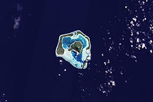
NASA picture of Maupiti.
Maupiti supply ship
The blue barrels on the dock are noni which is sent to Papeete for processing.

Maupiti is a small coral atoll with a volcanic island in its midst.

Contents

Geography

Maupiti is located to the west of the Leeward Islands in French Polynesia. It is the westernmost volcanic high island in the archipelago, 40 km west of Bora Bora. The central island of Maupiti has a high peak of 380 metres and a surface area of 11 square kilometers. The lagoon has large and flat coral islands in its northern reef half and two motus on both sides of the pass at its southern end.

Population

At the August 2007 census, the island population was about 1,200 people.

Economy

The primary economic activity on Maupiti is noni production.

History

There are ancient Polynesian archaeological artefacts dating from at least AD 850 in Maupiti. The first European to arrive on the island was the Dutchman Jakob Roggeveen in 1722. Historically, the island has had strong cultural links with Bora Bora.

Administration

Maupiti is administratively part of the commune (municipality) of Maupiti, itself in the administrative subdivision of the Leeward Islands. The main settlement is Vaiea.

References

External links


Wikimedia Foundation. 2010.

Игры ⚽ Поможем написать реферат

Look at other dictionaries:

  • Maupiti — Astronautenfoto von Maupiti Gewässer Pazifischer Ozean Archipel Gesellschaftsinseln …   Deutsch Wikipedia

  • MAUPITI — Une des îles Sous le Vent en Polynésie française, Maupiti est située à un peu moins de 50 kilomètres à l’ouest de Bora Bora, par 160 26 de latitude sud et 1540 32 de longitude ouest. Elle est peu étendue (environ 25 km2) et les restes du volcan… …   Encyclopédie Universelle

  • Maupiti — es una de las islas de Sotavento de las islas de la Sociedad, en la Polinesia Francesa. Es la isla volcánica más occidental del archipiélago, a 40 km al oeste de Bora Bora. Sus coordenadas son: 16°25′S 152°15′O /  …   Wikipedia Español

  • Maupiti — (Maurna), eine der bewohnten Gesellschaftsinseln (südöstliches Polynesien), von Riffen umgeben, gute Häfen; gebirgig, aber fruchtbar …   Pierer's Universal-Lexikon

  • Maupiti — Pour les articles homonymes, voir Maupiti (homonymie). Maupiti Carte topographique des îles et atolls de la …   Wikipédia en Français

  • Maupiti (commune) — Maupiti Location of the commune (in red) within the Leeward Islands. The atolls of Maupihaa (Mopelia), Manuae (Scilly), and Motu One (Bellinghausen) lie outside of the map …   Wikipedia

  • Maupiti-Monarch — (Pomarea pomarea) Systematik Klasse: Vögel (Aves) Ordnung: Sperlings …   Deutsch Wikipedia

  • Maupiti Airport — IATA: MAU – ICAO: NTTP Summary Airport type Public Operator Government Location …   Wikipedia

  • Maupiti Island (game) — Maupiti Island Developer(s) Lankhor Publisher(s) Lankhor Designer(s) Sylvian Bruchon, Dominique Sablons, André Bescond …   Wikipedia

  • Maupiti Monarch — Conservation status Extinct (IUCN 3.1) …   Wikipedia

Share the article and excerpts

Direct link
Do a right-click on the link above
and select “Copy Link”