- Victoria Falls
-
Victoria Falls 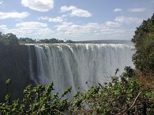
Victoria FallsLocation Livingstone, Zambia
Victoria Falls, ZimbabweCoordinates 17°55′28″S 25°51′24″E / 17.92444°S 25.85667°ECoordinates: 17°55′28″S 25°51′24″E / 17.92444°S 25.85667°E Type Waterfall Total height 108 metres (360 ft) Number of drops 1 Watercourse Zambezi River Average flow rate 1088 m³/s (38,430 cu ft/s) Official name: Mosi-oa-Tunya / Victoria Falls Type: Natural Criteria: vii, viii Designated: 1989 (13th session) Reference #: 509 State Party: Zambia and Zimbabwe Region: Africa 
 Location
The Victoria Falls or Mosi-oa-Tunya (the Smoke that Thunders, and note that the 'i' is silent) is a waterfall located in southern Africa on the Zambezi River between the countries of Zambia and Zimbabwe.
Contents
Introduction
 At lower water levels, more of the First Gorge can be seen
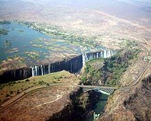
David Livingstone, the Scottish missionary and explorer, is believed to have been the first European recorded to view the Victoria Falls — which he did from what is now known as 'Livingstone Island' in Zambia, the only land accessible in the middle of the falls.[1] David Livingstone gave the falls the name 'Victoria Falls' in honour of his Queen, but the indigenous name of 'Mosi-oa-Tunya' — literally meaning the 'Smoke that Thunders' — is also well known. The World Heritage List recognizes both names.[2] While it is neither the highest nor the widest waterfall in the world, it is claimed to be the largest. This claim is based on a width of 1,708 metres (5,604 ft)[3] and height of 108 metres (354 ft), forming the largest sheet of falling water in the world. The falls' maximum flow rate compares well with that of other major waterfalls (see table below).[2]
For a considerable distance upstream from the falls, the Zambezi flows over a level sheet of basalt, in a shallow valley bounded by low and distant sandstone hills. The river's course is dotted with numerous tree-covered islands, which increase in number as the river approaches the falls. There are no mountains, escarpments, or deep valleys which might be expected to create a waterfall, only flat plateau extending hundreds of kilometres in all directions.
The falls are formed as the full width of the river plummets in a single vertical drop into a transverse chasm 1708 metres (5604 ft) wide, carved by its waters along a fracture zone in the basalt plateau. The depth of the chasm, called the First Gorge, varies from 80 metres (260 ft) at its western end to 108 metres (354 ft) in the centre. The only outlet to the First Gorge is a 110 metres (360 ft) wide gap about two-thirds of the way across the width of the falls from the western end, through which the whole volume of the river pours into the Victoria Falls gorges.
There are two islands on the crest of the falls that are large enough to divide the curtain of water even at full flood: Boaruka Island (or Cataract Island) near the western bank, and Livingstone Island near the middle — the place that David Livingstone first saw the falls from in Zambia. At less than full flood, additional islets divide the curtain of water into separate parallel streams. The main streams are named, in order from Zimbabwe (west) to Zambia (east): Devil's Cataract (called Leaping Water by some), Main Falls, Rainbow Falls (the highest) and the Eastern Cataract
‘The Smoke that Thunders’, rainy season, 1972 ... and dry season, September 2003Size and flow rate of Victoria Falls with Niagara and Iguazu for comparison Parameters Victoria Falls Niagara Falls Iguazu Falls Height in meters and feet:[2] 108m 360 ft 51 m 167 ft 64–82 m 210–269 ft Width in meters and feet:[2] 1,708 m 5,604 ft 1,203 m 3,947 ft 2,700 m 8,858 ft Flow rate units (vol/s): m³/s cu ft/s m³/s cu ft/s m³/s cu ft/s Mean annual flow rate:[2] 1,088 38,430 2,407 85,000 1,746 61,600 Mean monthly flow[4] — max: 3,000 105,944 — min:[4] 300 10,594 — 10yr max:[4] 6,000 211,888 Highest recorded flow:[2] 12,800 452,000 6,800 240,000 12,600 444,965 Notes: See references for explanation of measurements.
For water, cubic metres per second = tonnes per second.
Half the water approaching Niagara is diverted for hydroelectric power.
Iguazu has two drops; height given for biggest drop and total height.
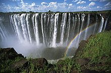
10 falls have greater or equal flow rates, but are not as high as Iguazu and Victoria Falls.[4]The Zambezi basin above the falls experiences a rainy season from late November to early April, and a dry season the rest of the year. The river's annual flood season is February to May with a peak in April,[4] The spray from the falls typically rises to a height of over 400 metres (1,300 ft), and sometimes even twice as high, and is visible from up to 50 km (31 mi) away. At full moon, a "moonbow" can be seen in the spray instead of the usual daylight rainbow. During the flood season, however, it is impossible to see the foot of the falls and most of its face, and the walks along the cliff opposite it are in a constant shower and shrouded in mist. Close to the edge of the cliff, spray shoots upward like inverted rain, especially at Zambia's Knife-Edge Bridge.[5] As the dry season takes effect, the islets on the crest become wider and more numerous, and in September to January up to half of the rocky face of the falls may become dry and the bottom of the First Gorge can be seen along most of its length. At this time it becomes possible (though not necessarily safe) to walk across some stretches of the river at the crest. It is also possible to walk to the bottom of the First Gorge at the Zimbabwean side. The minimum flow, which occurs in November, is around a tenth of the April figure; this variation in flow is greater than that of other major falls, and causes Victoria Falls' annual average flow rate to be lower than might be expected based on the maximum flow.[5]
Victoria Falls is roughly twice the height of North America's Niagara Falls and well over twice the width of its Horseshoe Falls. In height and width Victoria Falls is rivalled only by South America's Iguazu Falls. See table for comparisons.
The Victoria Falls Gorges
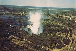
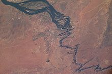 Satellite image showing the broad Zambezi falling into the narrow cleft and subsequent series of zigzagging gorges (top of picture is north).
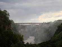 Victoria Falls Bridge spanning the Second Gorge.
The whole volume of the Zambezi River pours through the First Gorge's 110-meter-wide (360 ft) exit for a distance of about 150 meters (500 ft), then enters a zigzagging series of gorges designated by the order in which the river reaches them. Water entering the Second Gorge makes a sharp right turn and has carved out a deep pool there called the Boiling Pot. Reached via a steep footpath from the Zambian side, it is about 150 metres (500 ft) across. Its surface is smooth at low water, but at high water is marked by enormous, slow swirls and heavy boiling turbulence.[5] Objects—and humans—that are swept over the falls, including the occasional hippo, are frequently found swirling about here or washed up at the north-east end of the Second Gorge. This is where the bodies of Mrs Moss and Mr Orchard, mutilated by crocodiles, were found in 1910 after two canoes were capsized by a hippo at Long Island above the falls.[6]
The principal gorges are (see reference for note about these measurements):[7]
- First Gorge: the one the river falls into at Victoria Falls
- Second Gorge: (spanned by the Victoria Falls Bridge), 250 m south of falls, 2.15 km long (270 yd south, 2350 yd long)
- Third Gorge: 600 m south, 1.95 km long (650 yd south, 2100 yd long), containing the Victoria Falls Power Station.
- Fourth Gorge: 1.15 km south, 2.25 km long (1256 yd south, 2460 yd long)
- Fifth Gorge: 2.55 km south, 3.2 km long (1.5 mi south, 2 mi (3.2 km) long)
- Songwe Gorge: 5.3 km south, 3.3 km long, (3.3 mi south, 2 mi (3.2 km) long) named after the small Songwe River coming from the north-east, and the deepest at 140 m (460 ft), the level of the river in them varies by up to 20 meters (65 ft) between wet and dry seasons.[5]
Formation
 "Devil's Cataract", the westernmost cataract of Victoria Falls and the start of a line of weakness where the next falls will form.
The recent geological history of Victoria Falls can be seen in the form of the gorges below the falls. The basalt plateau over which the Upper Zambezi flows has many large cracks filled with weaker sandstone. In the area of the current falls the largest cracks run roughly east to west (some run nearly north-east to south-west), with smaller north-south cracks connecting them.
Over at least 100,000 years, the falls have been receding upstream through the Batoka Gorges, eroding the sandstone-filled cracks to form the gorges. The river's course in the current vicinity of the falls is north to south, so it opens up the large east-west cracks across its full width, then it cuts back through a short north-south crack to the next east-west one. The river has fallen in different eras into different chasms which now form a series of sharply zig-zagging gorges downstream from the falls.[5]
Ignoring some dry sections, the Second to Fifth and the Songwe Gorges each represents a past site of the falls at a time when they fell into one long straight chasm as they do now.[5] Their sizes indicate that we are not living in the age of the widest-ever falls.
The falls have already started cutting back the next major gorge, at the dip in one side of the "Devil's Cataract" (also known as "Leaping Waters") section of the falls. This is not actually a north-south crack, but a large east-northeast line of weakness across the river, where the next full-width falls will eventually form.
Further geological history of the course of the Zambezi River is in the article of that name.
Pre-colonial history
Archaeological sites around the falls have yielded Homo habilis stone artifacts from 3 million years ago[citation needed], 50,000-year-old Middle Stone Age tools and Late Stone Age (10,000 and 2,000 years ago) weapons, adornments and digging tools.[8] Iron-using Khoisan hunter-gatherers displaced these Stone Age people and in turn were displaced by Bantu tribes such as the southern Tonga people known as the Batoka/Tokalea, who called the falls Shungu na mutitima. The Matabele, later arrivals, named them aManz' aThunqayo, and the Batswana and Makololo (whose language is used by the Lozi people) call them Mosi-o-Tunya. All these names mean essentially "the smoke that thunders".[9]
The first European to see the falls was David Livingstone on 17 November 1855, during his 1852–56 journey from the upper Zambezi to the mouth of the river. The falls were well known to local tribes, and Voortrekker hunters may have known of them, as may the Arabs under a name equivalent to "the end of the world". Europeans were sceptical of their reports, perhaps thinking that the lack of mountains and valleys on the plateau made a large falls unlikely.[10][11]
Livingstone had been told about the falls before he reached them from upriver and was paddled across to a small island that now bears the name Livingstone Island in Zambia. Livingstone had previously been impressed by the Ngonye Falls further upstream, but found the new falls much more impressive, and gave them their English name in honour of Queen Victoria. He wrote of the falls, "No one can imagine the beauty of the view from anything witnessed in England. It had never been seen before by European eyes; but scenes so lovely must have been gazed upon by angels in their flight."[5]
In 1860, Livingstone returned to the area and made a detailed study of the falls with John Kirk. Other early European visitors included Portuguese explorer Serpa Pinto, Czech explorer Emil Holub, who made the first detailed plan of the falls and its surroundings in 1875 (published in 1880),[12] and British artist Thomas Baines, who executed some of the earliest paintings of the falls. Until the area was opened up by the building of the railway in 1905, though, the falls were seldom visited by other Europeans.
History since 1900
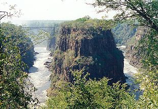 Victoria Falls' Second Gorge (with bridge) and Third Gorge (right). The peninsular cliffs are in Zambia, the outer cliffs in Zimbabwe.
The Victoria Falls Bridge initiates tourism
European settlement of the Victoria Falls area started around 1900 in response to the desire of Cecil Rhodes' British South Africa Company for mineral rights and imperial rule north of the Zambezi, and the exploitation of other natural resources such as timber forests north-east of the falls, and ivory and animal skins. Before 1905, the river was crossed above the falls at the Old Drift, by dugout canoe or a barge towed across with a steel cable.[6] Rhodes' vision of a Cape-Cairo railway drove plans for the first bridge across the Zambezi and he insisted it be built where the spray from the falls would fall on passing trains, so the site at the Second Gorge was chosen. See the main article Victoria Falls Bridge for details.[5] From 1905 the railway offered accessible travel to whites from as far as the Cape in the south and from 1909, as far as the Belgian Congo in the north. In 1904 the Victoria Falls Hotel was opened to accommodate visitors arriving on the new railway. The falls became an increasingly popular attraction during British colonial rule of Northern Rhodesia (Zambia) and Southern Rhodesia (Zimbabwe), with the town of Victoria Falls becoming the main tourist centre.
Zambia's independence and Rhodesia's UDI
In 1964, Northern Rhodesia became the independent state of Zambia. The following year, Rhodesia unilaterally declared independence. This was not recognized by Zambia, the United Kingdom or the vast majority of states and led to UN-mandated sanctions. In response to the emerging crisis, in 1966 Zambia restricted or stopped border crossings; it did not re-open the border completely until 1980. Guerilla warfare arose on the southern side of the Zambezi from 1972: the Zimbabwe-Rhodesia War. Visitor numbers began to drop, particularly on the Rhodesian (Zimbabwean) side. The war affected Zambia through military incursions, causing the latter to impose security measures including the stationing of soldiers to restrict access to the gorges and some parts of the falls.
Zimbabwean independence in 1980 brought comparative peace, and the 1980s witnessed renewed levels of tourism and the development of the region as a centre for adventure sports. Activities that gained popularity in the area include whitewater rafting in the gorges, bungee jumping from the bridge, game fishing, horse riding, kayaking, and flights over the falls.[8]
Tourism in recent years
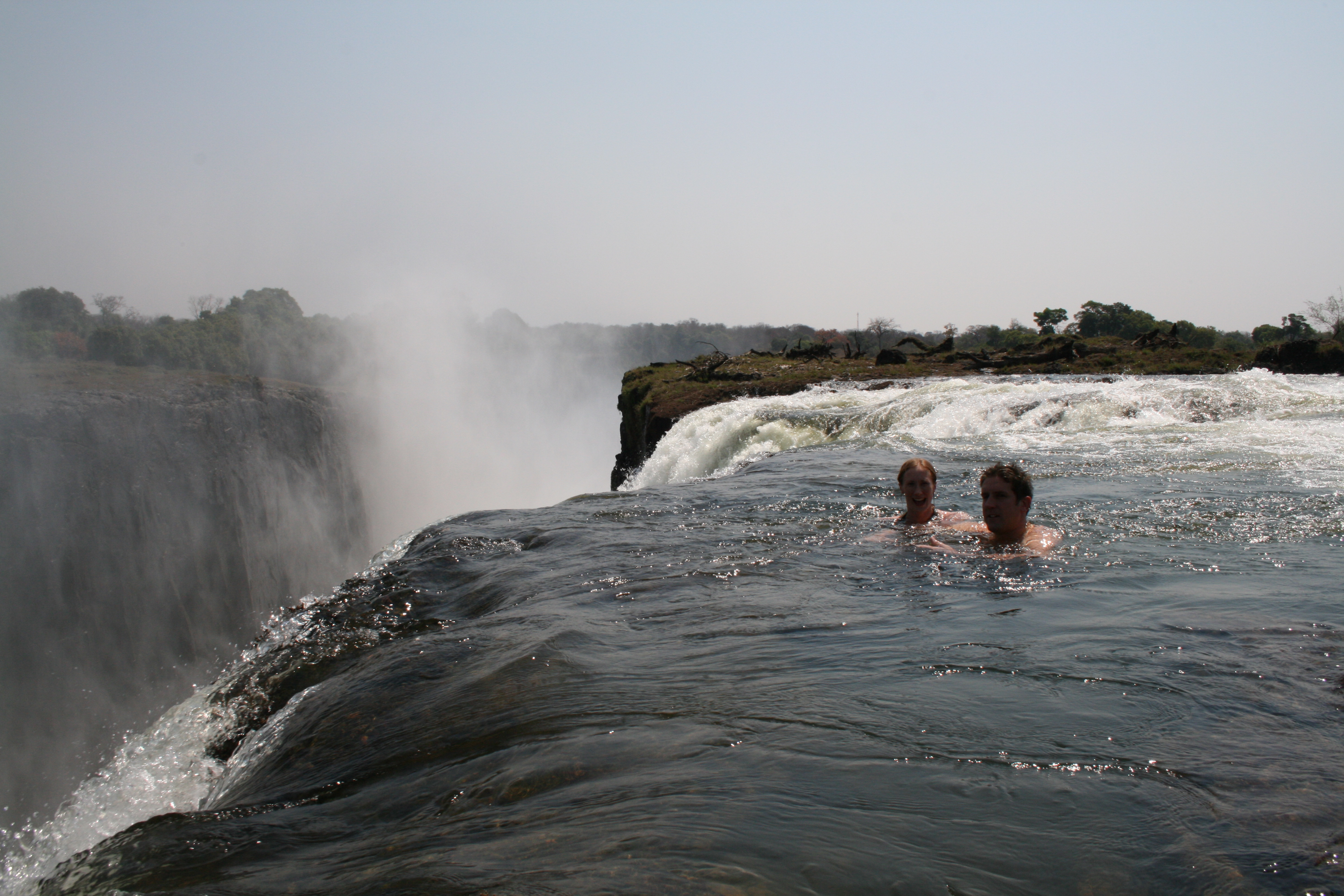
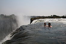 "Devil's Pool", a naturally formed safe swimming pool.
 Victoria Falls entrance
By the end of the 1990s, almost 300,000 people were visiting the falls annually, and this was expected to rise to over a million in the next decade. Unlike the game parks, Victoria Falls has more Zimbabwean and Zambian visitors than international tourists as they are accessible by bus and train and therefore comparatively inexpensive to reach. This waterfall was the very first destination ever to be visited in The Amazing Race.[8]
The two countries permit tourists to make day trips from each side and visas can be obtained at the border posts. Costs vary from us$20-50.00. Visitors with single entry visas will need to purchase a visa each time they cross the border. Regular changes in visa regulations mean visitors should check the rules before crossing the border.
A famous feature is a naturally formed pool known as the Devil's Pool, near the edge of the falls, accessed via Livingstone Island in Zambia. When the river flow is at a safe level, usually during the months of September to December, people can swim as close as possible to the edge of the falls within the pool without continuing over the edge and falling into the gorge; this is possible due to a natural rock wall just below the water and at the very edge of the falls that stops their progress despite the current.
The numbers of visitors to the Zimbabwean side of the falls has historically been much higher than the number visiting the Zambia side, due to the greater development of the visitor facilities there. However, the number of tourists visiting Zimbabwe began to decline in the early 2000s as political tensions between supporters and opponents of president Robert Mugabe increased. In 2006, hotel occupancy on the Zimbabwean side hovered at around 30%, while the Zambian side was at near-capacity, with rates in top hotels reaching US$630 per night.[13][14] The rapid development has prompted the United Nations to consider revoking the Falls' status as a World Heritage Site.[15] In addition, problems of waste disposal and a lack of effective management of the falls' environment are a concern.[16]
Natural environment
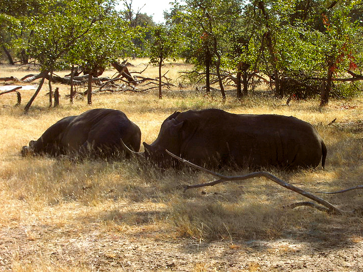
 Two white rhinos at Mosi-oa-Tunya national park in May 2005. They are not indigenous, but were imported from South Africa.
National parks
The two national parks at the falls are relatively small — Mosi-oa-Tunya National Park is 66 square kilometres (16,309 acres) and Victoria Falls National Park is 23 square kilometres (5,683 acres). However, next to the latter on the southern bank is the Zambezi National Park, extending 40 kilometres (25 mi) west along the river.[5] Animals can move between the two Zimbabwean parks and can also reach Matetsi Safari Area, Kazuma Pan National Park and Hwange National Park to the south.[8]
On the Zambian side, fences and the outskirts of Livingstone tend to confine most animals to the Mosi-oa-Tunya National Park. In addition fences put up by lodges in response to crime restrict animal movement.[16]
Vegetation
Mopane woodland savannah predominates in the area, with smaller areas of Miombo and Rhodesian Teak woodland and scrubland savannah. Riverine forest with palm trees lines the banks and islands above the falls. The most notable aspect of the area's vegetation though is the rainforest nurtured by the spray from the falls, containing plants rare for the area such as pod mahogany, ebony, ivory palm, wild date palm and a number of creepers and lianas.[8] Vegetation has suffered in recent droughts, and so have the animals that depend on it, particularly antelope.
Wildlife
The national parks contain abundant wildlife including sizable populations of elephant, buffalo, giraffe, zebra, and a variety of antelope. Lion and leopard are only occasionally seen. Vervet monkeys and baboons are common. The river above the falls contains large populations of hippopotamus and crocodile. Elephants cross the river in the dry season at particular crossing points.[8]
Klipspringers and clawless otters can be glimpsed in the gorges, but they are mainly known for 35 species of raptors. The Taita Falcon, Black Eagle, Peregrine Falcon and Augur Buzzard breed there. Above the falls, herons, Fish Eagles and numerous kinds of waterfowl are common.[8]
Fish
The river is home to 39 species of fish below the falls and 89 species above it. This illustrates the effectiveness of the falls as a dividing barrier between the upper and lower Zambezi.[8]
Media
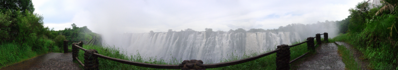 The Victoria Falls (Mosi-oa-Tunya), Livingstone, Zambia: A panoramic view from the Zambian side near the Knife-edge bridge
See also
- List of waterfalls by flow rate
References
- ^ Livingstone Tourism Association
- ^ a b c d e f World Waterfalls Website accessed 1 March 2007
- ^ Southern Africa Places (2009). Victoria Falls. Retrieved on 2009-05-18 from Victoria Falls - South Africa Places
- ^ a b c d e World Commission on Dams website: "Case Study — Kariba Dam-Zambezi River Basin" Annex 13 & 14 Victoria Falls Mean Monthly Flows. Website accessed 1 March 2007. This website gives mean monthly flow rates in cubic metres per second (i.e., the total volume of water passing in each calendar month divided by the number of seconds in the month), the standard measure used in hydrology to indicate seasonal variation in flow. A figure of around 9,000 m³/s (318,000 cu ft) is quoted by many websites for Victoria Falls but this is the mean maximum instantaneous rate, which is only achieved for a little amount of days per year. The figure of 536 million m³/minute (18.9 billion cu ft/min) on some websites (eg ZNTB) is an error for 536 million litres/minute (equivalent to 9100 m³/s or 142 million U.S. gallons/min). The '10-year maximum' is the mean of the maximum monthly rate returned in a ten-year period.
- ^ a b c d e f g h i compiled and edited by Camerapix (1996). Spectrum Guide to Zambia. Nairobi: Camerapix International Publishing. ISBN 978-1874041146.
- ^ a b The Northern Rhodesia Journal online, B. L. Hunt: "Kalomo to Livingstone in 1907". Vol IV No 1 (1959) p16. Accessed 28 February 2007. Mr Moss and Mrs Orchard and the eight Lozi paddlers managed to swim to the island, one of the paddlers saving the Orchards' year-old baby.
- ^ "Zambia — Gorges" on SatelliteViews.net accessed 28 February 2007
- ^ a b c d e f g h United Nations Environment Programme: Protected Areas and World Heritage World Conservation Monitoring Centre. Website accessed 1 March 2007.
- ^ The Northern Rhodesia Journal online: "Native Name of Victoria Falls", Vol I No 6 pp68 (1952). Accessed February 28, 2007.
- ^ The Northern Rhodesia Journal online: "Native Name of Victoria Falls", Vol I No 4 pp80–82 (1951). Accessed February 28, 2007.
- ^ Agter die Magalies": "Agter Die Magalies" B.K. de Beer, pp43–44 (1975) Postma Publications. Accessed September 1, 2007.
- ^ The international service of Czech Radio online: "Statue of explorer Emil Holub unveiled in Livingstone, Zambia" accessed 28 February 2007.
- ^ "At African Waterfall, Visitors Confront A Tale of Two Cities." Trofimov, Y. The Wall Street Journal. December 29, 2006.
- ^ Victoria Falls Journal; The Best of Times, and the Worst, for Two Tourist Towns
- ^ Victoria Falls 'at risk', UN warns The Independent, 7 January 2007
- ^ a b S Hanyona: "Zambia's Ecotourism Venture Clouded by Ecotroubles." March 5, 2002. ENS website accessed 9 March 2007.
External links
- Map of Area around Victoria Falls by Openstreetmap
- A useful list of further reading is included on the UNEP-WCMC website's page for Mosi-oa-Tunya.
- NASA Earth Observatory page
- Entry on UNESCO World Heritage site
- TIME magazine article about tourism in the area
- Devil's Pool Urban Legends Reference Page - Snopes.com
Categories:- Victoria Falls
- Canyons and gorges of Africa
- Visitor attractions in Zimbabwe
- Waterfalls of Zambia
- Waterfalls of Zimbabwe
- World Heritage Sites in Zimbabwe
- World Heritage Sites in Zambia
- Southern Province, Zambia
- Zambezi River
- Zambia–Zimbabwe border
- International waterfalls


Wikimedia Foundation. 2010.