- Shebaa farms
-
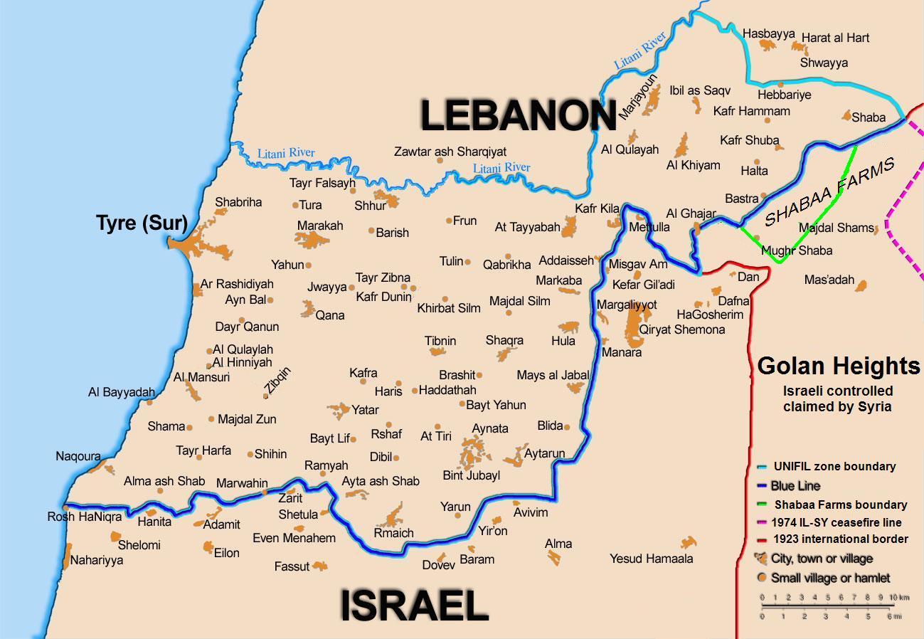
 Map of the Shebaa Farms.
The Shebaa Farms (Arabic: مزارع شبعا, Mazāri‘ Šib‘ā; Hebrew: חוות שבעא, Havot Sheba‘a or הר דוב, Har Dov) are a small uninhabited territory claimed by Lebanon, but occupied by Israel which claims they are in Syria's Golan Heights.[1][2] Syrian policy is to vaguely accept the Lebanese claim, while refusing any binding demarcation[3][4] until Israeli forces withdraw from the area.
The United Nations had to decide upon a "withdrawal line" for Israel to withdraw from the Lebanon (for Security Council Resolution 425).[5] The UN certified Israel's withdrawal as conforming to that line, which did not contain the Shebaa Farms. However the UN has proposed that Israel also withdraws from the Shebaa Farms and that it be considered international territory under UNIFIL.[6]
Documents from the 1920s and 1930s indicate that some local inhabitants regarded themselves as part of Lebanon, but after the French mandate ended in 1946, the land was administered by Syria, and represented as such in all maps of the time,[7] including 1949 Armistice Agreement maps[7] and Syrian and Lebanese military maps.[7] The Shebaa Farms were then occupied by Israel in the 1967 Six-Day War.
Contents
Geography
The area in question is about 9 km (5.5 mi) in length, and averages 2.5 km (1.5 mi) in width, coming to about 22 km² (8 sq mi). It is located about 3 to 12 km (2 to 7.5 mi) southwest of the Lebanese village of Shebaa, and about 5 to 7 km (3 to 4 mi) northwest of the Druze village of Majdal Shams. Shebaa Farms is situated on the southeastern side of a long, broad ridge descending to the southwest from Mount Hermon. The northwestern edge of the area corresponds to the international Lebanese-Syrian border (still recognized by the United Nations) along that ridge. The southeastern edge lies parallel to Wadi al-Asal (Nahal Si'on), a 16 km long wadi that flows into Israel, draining a portion of the relatively precipitation-rich Hermon ridge in the northern Golan Heights. These "edges" are connected by the Shebaa Farms' northeastern limit 2.5 km east of IDF military camp at Har Dov as defined by a 2007 UN report.[8]
The same report defines the southwestern limit as a line roughly following the foot of the ridge and starting at just over a kilometer northwest of Banias, then running northwest to the international Lebanon-Syrian border's sharp turning point 3.4 km east of Ghajar and 1.0 km "south of the (Lebanese) village of El Majidiye." This southwestern limit of Shebaa Farms comes within about 1 km of the 1949 Armistice Line, international border between Israeli and Syria. The only overland route between Lebanon and Syria south of the Mount Hermon ridge used to run between these two lines. The small farms in this area are not used since the Six-Day War. The area includes heights overlooking parts of southern Lebanon and Israel to the west. Elevations range from about 250 to about 1,500 m (825–4,940 ft).
Even after the Israeli military withdrawal from southern Lebanon in 2000, to the line designated by UN officials, Hezbollah cites what it sees as continued Israeli occupation of the disputed Shebaa Farms as justification for attacks on Israel. In a speech in August 2008, the president of Lebanon, Michel Suleiman stated: "The countdown for liberating the rest of our lands has begun. And today I confirm the [use] of all available and legitimate means to achieve this goal".[9]
Etymology
Lebanese press and officials often refer to this area, just southeast of the Lebanese village of Kafr Shuba, as the Kafr Shuba Hills. On old maps it is labelled Jebal ar Ru'us, Jebel Rous or Jabel Rous.[10]
Israel refers to the northern, higher part of the area as Har Dov (Mount Dov), named after Dov Rodberg, an IDF officer killed there in 1970.[11]
Current dispute
When Israel captured the Golan Heights from Syria in 1967 during the Six Day War, the Shebaa Farms were considered in practice to be part of the Syrian territory.[12] Lebanon was not an active participant in the war. In 1981 Israel extended Israeli law to the region under its Golan Heights Law.[13] The United Nations Security Council has declared this extension of "[Israeli] laws, jurisdiction and administration... null and void and without international legal effect" in Resolution 497, which was not passed with Chapter VII enforcement powers.
A controversy arose following the withdrawal of Israeli troops from occupied territory in Southern Lebanon on May 24, 2000. On June 18, 2000, the United Nations affirmed that Israel had withdrawn its forces from Lebanon, in accordance with Resolution 425.[5] Syria and Lebanon disputed the United Nations certification that Israel's withdrawal from Lebanon was complete. Hezbollah cites the ongoing occupation of the Shebaa farms as one reason for its continued attacks on Israel.
Between 2000–2005, Hezbollah attacked the IDF at Shebaa/Har Dov 33 times, resulting in seven Israeli soldiers killed in action, three taken prisoner, and dozens wounded.[14]
For decades members of the international diplomatic community have repeatedly requested that Syria and Lebanon take steps to determine the exact boundary between them in the Shebaa Farms region and Syria, including officially registering the demarcated border with the United Nations. However, recently President Bashar al-Assad of Syria has refused to do so until Israeli troops withdraw.[15] On October 31, 2007, the definition of the physical extent of the Shebaa Farms area by former UN cartographer Miklos Pinther was released by the UN.[8] This could be a prelude to an eventual negotiated demarcation of the territory.[16]
Background
Main article: French Mandate of LebanonThe dispute over the sovereignty of the Shebaa Farms resulted in part from the failure of the French Mandate administrations, and subsequently the Lebanese and Syrian governments, to demarcate the border between Lebanon and Syria properly.
Documents from the 1920s and 1930s indicate that some local inhabitants regarded themselves as part of Lebanon, for example paying taxes to the Lebanese government. But French officials at times expressed confusion as to the actual location of the border.[1] One French official in 1939 expressed the belief that the uncertainty was sure to cause trouble in the future.[1]
The region continued to be represented in the 1930s and 1940s as Syrian territory, under the French Mandate. Detailed maps showing the border were produced by the French in 1933, and again in 1945.[17] They clearly showed the region to be in Syria.
After the French Mandate ended in 1946, the land was administered by Syria, and represented as such in all maps of the time.[7]
The maps of the 1949 Armistice Agreements between Syria and Israel also designated the area as Syrian. Border disputes arose at times, however. Shebaa Farms was not unique; several other border villages had similar discrepancies of borders versus land ownership. Syria and Lebanon formed a joint Syrian-Lebanese border committee in the late 1950s to determine a proper border between the two nations. In 1964, concluding its work, the committee suggested to the two governments that the area be deemed the property of Lebanon, and recommended that the international border be reestablished consistent with its suggestion. However, neither Syria nor Lebanon adopted the committee's suggestion, and neither country took any action along the suggested lines. Thus, maps of the area continued to reflect the Farms as being in Syria.[7] Even maps of both the Syrian and Lebanese armies continued to demarcate the region within Syrian territory.[7]
 A Lebanese military map, published in 1966, showing the Shebaa Farms as being on the Syrian side of the border
A number of local residents regarded themselves as Lebanese, however. The Lebanese government showed little interest in their views. The Syrian government administered the region, and on the eve of the 1967 war, the region was under effective Syrian control.
In 1967 most Shebaa Farms landowners and (Lebanese) farmers lived outside the Syrian-controlled region, across the Lebanon-Syrian border, in the Lebanese village of Shebaa. During the Six Day War, Israel captured the area from Syria. As a consequence, the Lebanese landowners were no longer able to farm it.[18]
UN Security Council Resolution 242
Main article: United Nations Security Council Resolution 242In 1967, following the Six Day War, the United Nations Security Council passed Resolution 242 (1967),[19] later reaffirmed by UN Security Council Resolution 338 (1973),[20] calling for all four of the following:
- The "withdrawal of Israel armed forces from territories occupied in the recent conflict." There is a major dispute whether the language requires withdrawal from "all" occupied territories, the French text being "des territoires occupés," meaning "from the occupied territories." (For a discussion of the dispute, see the article on Resolution 242.) The territory is subject to this clause of Resolution 242, irrespective of whether it is considered part of Syria or Lebanon.
- The recognition by Israel, Egypt, Syria, and Jordan of each other.
- The termination of all claims or states of belligerency.
- The establishment of secure mutually recognized boundaries for all parties.
In 1981, the area was unofficially annexed by Israel, as part of the Golan Heights which ordered the implementation of Israeli civil law on the Golan Heights in lieu of the military administration.[21] This unilateral annexation is not recognised by the UN.
Operation Litani
In 1978 Israel invaded southern Lebanon in Operation Litani. The UN Security Council passed Resolution 425, calling on Israel:
- "to withdraw forthwith its forces from all Lebanese territory." The phrase "all territory" was used in Resolution 425, in contrast to the language in Resolution 242 (1967), which led to semantic disputes.
On May 22, 2000, Israel completed its withdrawal from southern Lebanon in accordance with Resolution 425.[22] The UN certified the completion of Israel's pullout.[5]
Lebanese claims
In 2000, Lebanon disputed Israel's compliance with Resolution 425. Lebanon claimed that the Shebaa Farms area was actually Lebanese, and demanded that the Israelis should therefore withdraw from there as well. Lebanon asserted that the UN certification of the Israeli withdrawal was "invalid," because of Lebanon's claim to the Farms.[23]
Lebanese officials point to land deeds, stamped by the Lebanese government, that were held by a number of area residents in the 1940s and 1950s. The Lebanese claim to this area is asserted by Hezbollah for its continuing conflict with Israel, and its cross-border attacks after the Israeli withdrawal. Senior Lebanese officials also linked the withdrawal of Israeli forces from Shebaa to Hezbollah’s disarmament. "If the U.S. and friendly countries help us achieve the withdrawal of Israel from Shebaa farms, this would make it possible for the Lebanese forces to be the sole owner of weapons and arms in the country," Lebanese Prime Minister Foaud Seniora said. Those comments were echoed by Lebanese President Émile Lahoud who said that "the resistance should be kept until a just and comprehensive peace is achieved in the region", adding that "if the Lebanese army were deployed along the borders (with Israel) ... it would be turned into a police force to protect Israel's borders, and this is not acceptable."[24]
Walid Jumblatt, a Lebanese Druze politician and leader of the Progressive Socialist Party, stated that Lebanon has no claims to the Shebaa farms.[25] However, both the prime minister and president stated that Lebanon does have a claim to the area. On August 28, 2006, Hezbollah fighters withdrew from positions facing Israeli occupation lines in the Shebaa Farms area.[26]
Maps published on the Lebanese army website show different versions of the Lebanese southern border. While the Shebaa Farms themselves are not marked on the maps, it is evident from one map[27] that the border runs north of the Shebaa Farms, while another map[28] marks the border south of the Farms.
A Lebanese newspaper, however, described the land deed of one Shebaa resident as "handwritten and signed on a yellowing piece of paper in pencil and ink." Moreover, it is quite common for Lebanese to own land in Syria, and vice versa and it is also common for many people of a country to not know the name of one region.[29]
According to the Arab newspaper, Al-Hayat, most Lebanese had never heard or read about the Farms, even in their national school curricula.[30] "The issue over these farms was created to justify resistance operations from Lebanon after the UN had created the Blue Line following Israel's withdrawal from Lebanon. The Shebaa farms were placed inside Syrian territory. It should be noted that Syria, which claims that the farms are Lebanese, has not presented a single document to the UN to prove it. Moreover, Syria refuses to demarcate its borders with Lebanon."[31]
Syrian claims
Syria has at times supported Lebanon's claim that the Shebaa Farms are part of Lebanon and not Syrian territory, at the UN and in official government press releases. But at other times it has made contrary statements. In August 1972, Syrian president Hafez al-Assad said, "Syria and Lebanon are a single country."[32] The Shebaa Farms also appear as part of Syria on the large-scale map on the Syrian Ministry of Tourism's website.[33] On May 16, 2000, the Syrian Foreign Minister, Farouq al-Shara, indicated to UN Secretary-General Kofi Annan in a telephone conversation that Syria supported Lebanon's claim.[34] This was made public in the UN Press Release SC/6878 of June 18, 2000 which stated "Concerning the Shab'a farmlands, both Lebanon and Syria state that this land belongs to Lebanon."[5]
However, on January 21, 2006, the President of Syria Bashar al-Assad stated in a speech before the convention of the Arab Lawyers Union in Damascus and translated into English by SANA, the official state news agency of Syria that there are two legal requirements for demarcating the border: first, the complaint must be registered with the UN; and second, engineers must precisely define the border. As neither Syria nor Lebanon have access to the area, Assad argues that resolution is waiting on Israeli withdrawal from the occupied territory.[35]
In an interview with Assad reported by SANA on August 24, 2006, Assad flatly refused demarcation of the Syrian/Lebanese border near Shebaa Farms before a withdrawal of Israeli troops.[36]
Former Vice President of Syria Abdel-Halim Khaddam, in an interview with the Lebanese Future Television on August 27, 2006, said: "Saying that the farms are occupied, and hence cannot be demarcated, is nothing but a pretext. The demarcation would not take more than an hour if there was a political will."[37]
Israeli claims
Israel claims that the area is not covered by UN Security Council Resolution 425, which governed Israel's withdrawal from Lebanon, stating that the Farms were not Lebanese territory. In support of that view, Israel points to the fact that the UN certified Israel's pullout from Lebanon as having been completed.[5]
Israel says the land was Syrian when it was captured during the Six Day War, and the dispute is being used by Hezbollah to continue its attacks on Israel.
On June 21, 2008, DEBKAFile claimed that in a June 15, 2008, meeting in Jerusalem, Israeli Prime Minister Ehud Olmert told US Secretary of State Condoleezza Rice that he was "willing to evacuate Israeli troops and hand [the Shebaa farms] to United Nations custody as early as July."[38]
US position
John Bolton, former United States Ambassador to the United Nations, said on April 26, 2006: "I think the overwhelming preponderance of the evidence is that Shebaa Farms is Syrian territory."[39]
In July 2006, Nancy Soderberg, former United States Ambassador to the United Nations, wrote:
- "When it was clear the Israelis were going to withdraw fully from Lebanon, Syrian and Lebanese officials fabricated the fiction that this small, sparsely populated area was part of Lebanon. They even produced a crudely fabricated map to back up the dubious claim. I and United Nations officials went into the map room in the United Nations and looked at all the maps of the region in the files for decades. All showed the Shebaa Farms clearly in Syria."[40]
Former US president Jimmy Carter suggested in the Washington Post on August 1, 2006, that: "Israel should withdraw from all Lebanese territory, including Shebaa Farms."[41]
In June, 2008, US Secretary of State Condoleezza Rice visited Beirut, stating that "the United States believes that the time has come to deal with the Shebaa Farms issue ... in accordance with [U.N. Security Council Resolution] 1701."[42]
UN position
 A map showing the Blue Line, a rough delineation of the Shabaa Farm area and the UNIFIL deployment area
The United Nations certified Israel's pullout under Resolution 425 as conforming to the "withdrawal line" it had laid down in accordance with the maps at its disposal [5] "for the practical purpose of confirming the Israeli withdrawal".[34] At the same time the UN noted that its decision was "without prejudice to future border agreements between the Member States concerned," referring to Israel, Syria, and Lebanon. The UN stated:
- "On May 15, 2000, the United Nations received a map, dated 1966, from the Government of Lebanon which reflected the Government's position that these farmlands were located in Lebanon. However, the United Nations is in possession of 10 other maps issued after 1966 by various Lebanese government institutions, including the Ministry of Defense and the army, all of which place the farmlands inside the Syrian Arab Republic. The United Nations has also examined six maps issued by the Government of the Syrian Arab Republic, including three maps since 1966, which place the farmlands inside the Syrian Arab Republic."[34]
In a June 18, 2000 statement, the Security Council noted that Israel and Lebanon had confirmed to the Secretary General, that identification of the withdrawal line was solely the responsibility of the UN and that both sides would respect the line as identified. On a fact-finding visit to the region, Terje Rød-Larsen, the UN special envoy to the Middle East, noted that the 1923 Anglo-French demarcation and the 1949 Armistice line clearly designated the area as Syrian territory.[29]
In April 2002, UN Secretary-General Kofi Annan, said:
- "With reference to the disturbances along the Blue Line emanating from Lebanese territory, I call on the Government of Lebanon and all relevant parties to condemn and prevent such violations. The Security Council itself confirmed in June 2000 that Israel had withdrawn from southern Lebanon in compliance with UN Security Council resolutions 425 and 426. Attacks at any point along the Blue Line, including in the Shebaa Farms area in the occupied Golan Heights, are violations of Security Council resolutions. Respect for decisions of the Security Council is the most basic requirement of international legitimacy."
On January 20, 2005 UN Secretary-General's report on Lebanon stated:
- "The continually asserted position of the Government of Lebanon that the Blue Line is not valid in the Shab'a farms area is not compatible with Security Council resolutions. The Council has recognized the Blue Line as valid for purposes of confirming Israel’s withdrawal pursuant to resolution 425 (1978). The Government of Lebanon should heed the Council’s repeated calls for the parties to respect the Blue Line in its entirety."[43]
The BBC quoted Timur Goskel, a spokesman for the United Nations Interim Force in Lebanon (UNIFIL) as saying that "no-one disputed that the village of Shebaa itself was in Lebanon, but most of the farms fell into an undefined area that may be either in Lebanon or Syria" and although the UN was not a "boundary marking authority [...] on all maps the UN has been able to find, the farms are seen on the Syrian side [of the border]."[2]
Arab league
The Arab League backed Lebanon's claim with a communique issued at Arab League's 13th session in 2001, asking for "complete Israeli withdrawal from all occupied Palestinian territory, including Jerusalem, from the occupied Syrian Golan Heights to the line of June 4, 1967 and from the remaining occupied Lebanese territory up to the internationally recognized borders, including the Shab`a farmlands".[44]
Research findings
In 2002, Asher Kaufman of the Harry S. Truman Research Institute at the Hebrew University of Jerusalem, discovered previously unknown documents in French government archives. In one, French litigants in a private dispute entered into a private commercial agreement that suggested that the border should put the Farms in Lebanon. Two other documents, from 1937 and 1939, were reports from the administrative councilor of south Lebanon and the head of the Services Speciaux in the Syrian town of Quneitra. They noted a discrepancy between the border, as determined by the 1:200,000 Ottoman map, and their view of the "reality" in the region. Collecting "unofficial information" from "various sources," they concluded that in their view the area was Lebanese. Their conclusion was based on the facts that: a) some area residents paid taxes to Lebanon; and b) three or four sheep pens in the Farms belonged to residents of the Lebanese village of Shaba. After Kaufman published his findings, an editorial in the Daily Star of Lebanon chided the Lebanese academic community, indicating that it was embarrassing that the discovery had been left to an Israeli researcher.[45]
In a book published in 1988, Moshe Braver, an Israeli geographer, mentions two French maps published in 1932 and 1946, the former shows the farm area as being part of Lebanon while the latter shows the area as a Syrian territory.[46]
See also
References
- ^ a b c Kaufman, Asher (2004). "Understanding the Sheeba Farms dispute". Palestine-Israel Journal 11 (1). http://www.pij.org/details.php?id=9. Retrieved July 22, 2006.
- ^ a b "In focus: Shebaa farms". BBC News. May 25, 2000. http://news.bbc.co.uk/1/hi/world/middle_east/763504.stm. Retrieved September 29, 2006.
- ^ "Khaddam reiterates charge that Damascus killed Hariri". The Daily Star (Lebanon). August 29, 2006. http://www.dailystar.com.lb/article.asp?edition_id=1&categ_id=2&article_id=75088. Retrieved September 29, 2006
- ^ http://www.naharnet.com/domino/tn/NewsDesk.nsf/getstory?openform&0D3B02B4E37D7952C225748D005196E3
- ^ a b c d e f "Security council endorses secretary-general's conclusion on Israeli withdrawal from Lebanon as of June 16". United Nations Security Council. June 18, 2000. http://www.un.org/News/Press/docs/2000/20000618.sc6878.doc.html. Retrieved September 29, 2006.
- ^ http://www.haaretz.com/print-edition/news/un-tells-israel-place-shaba-farms-in-hands-of-unifil-1.225283
- ^ a b c d e f Kaufman, Asher (Autumn 2002). "Who owns the Shebaa Farms? Chronicle of a territorial dispute". Middle East Journal (Middle East Institute) 56 (4): 576–596.
- ^ a b UN Security Council document S/2007/641, paragraph 58
- ^ Sana Abdallah (August 1, 2008). "Lebanon to Release Statement on National Resistance, Hezbollah Weapons". Middle East Times. http://www.metimes.com/International/2008/08/01/lebanon_to_release_statement_on_national_resistance_hezbollah_weapons/7538. Retrieved August 1, 2008.[dead link]
- ^ "Jebel Rous, Syrian Arab Republic". EarthSearch.net. http://www.earthsearch.net/intSearch.php?showMap=-2546761&UNI=-3506417&earth=frag. Retrieved September 29, 2006.
- ^ Erlich, Reuven (August 9, 2006) (PDF). Raising the issue of the Sheba’a Farms in the proposed American-French Security Council draft resolution for ending the fighting: background information and significance. Intelligence and Terrorism Information Center at the Center for Special Studies. p. 7. http://www.terrorism-info.org.il/malam_multimedia/English/eng_n/pdf/sheba_farms_e.pdf. Retrieved September 29, 2006.
- ^ "The Legal Status of the Shabaa Farms". Israel Ministry of Foreign Affairs. April 8, 2002. http://www.mfa.gov.il/mfa/about%20the%20ministry/mfa%20spokesman/2002/the%20legal%20status%20of%20the%20shabaa%20farms%20-%208-apr-2002. Retrieved August 8, 2006.
- ^ "Golan Heights Law". Israel Ministry of Foreign Affairs. December 14, 1981. http://www.mfa.gov.il/MFA/Peace+Process/Guide+to+the+Peace+Process/Golan+Heights+Law.htm. Retrieved August 16, 2006.
- ^ Hezbollah attacks at Har Dov
- ^ Hani M. Bathish (May 9, 2007). "Ban cites Hizbullah's arms as 'key' threat to government's authority". The Daily Star. http://www.dailystar.com.lb/article.asp?edition_id=1&categ_id=2&article_id=82088. Retrieved May 8, 2007.
- ^ Aluf Benn (September 7, 2007). "UN cartographer to plot Shaba Farms border boundaries". Haaretz. http://www.haaretz.com/hasen/spages/901363.html. Retrieved September 7, 2007.
- ^ "Beyrouth" 1:200,000 sheet NI36-XII available in the U.S. Library of Congress and French archives.
- ^ Nasser, Cilina (April 25, 2005). "The key to Shebaa". Al Jazeera. Archived from the original on 2006-08-13. http://web.archive.org/web/20060813193722/http://english.aljazeera.net/NR/exeres/717FD283-592E-44BA-8A22-9D46B441C304.htm. Retrieved July 23, 2006.
- ^ "Resolution 242 (1967) of November 22, 1967". United Nations Security Council. November 22, 1967. Archived from the original on 2007-03-04. http://web.archive.org/web/20070304180833/http://domino.un.org/unispal.nsf/9a798adbf322aff38525617b006d88d7/7d35e1f729df491c85256ee700686136!OpenDocument. Retrieved September 29, 2006.
- ^ "Resolution 338 (1973) of October 22, 1973". United Nations Security Council. October 22, 1973. Archived from the original on September 2, 2006. http://web.archive.org/web/20060902045122/http://domino.un.org/unispal.nsf/9a798adbf322aff38525617b006d88d7/7fb7c26fcbe80a31852560c50065f878!OpenDocument. Retrieved September 29, 2006.
- ^ Bard, Mitchell G (March 13, 2006) (PDF). Myths and Facts: A Guide to the Arab-Israeli Conflict (3rd ed.). American-Israeli Cooperative Enterprise. ISBN 0-9712945-4-2. http://www.jewishvirtuallibrary.org/jsource/myths2/myths2006.pdf.
- ^ "Resolution 425 (1978) of March 19, 1978". United Nations Security Council. March 19, 1978. Archived from the original on 2006-10-06. http://web.archive.org/web/20061006142108/http://domino.un.org/UNISPAL.NSF/d744b47860e5c97e85256c40005d01d6/e25dae8e3ce54fb5852560e50079c708!OpenDocument. Retrieved September 29, 2006.
- ^ United Nations Secretary-General Kofi Annan (June 16, 2000). Report of the Secretary-General on the implementation of Security Council resolutions 425 (1978) and 426 (1978). S/2000/590. United Nations Security Council. Archived from the original on 2006-08-28. http://web.archive.org/web/20060828225429/http://domino.un.org/UNISPAL.nsf/b86613e7d92097880525672e007227a7/736411af9bc6369585256903004f90c1!OpenDocument. Retrieved July 23, 2006.
- ^ "Shebaa farmers view Hezbollah as their savior". islamonline. May 27, 2006. http://www.islamonline.com/cgi-bin/news_service/middle_east_full_story.asp?service_id=11286. Retrieved July 23, 2006.[dead link]
- ^ Waked, All (March 15, 2005). "Lebanese leader: Mount Dov not ours". Ynetnews. http://www.ynetnews.com/articles/0,7340,L-3058858,00.html. Retrieved September 29, 2006.
- ^ Wright, Jonathan (August 29, 2006). "News analysis: Hezbollah seen surviving UN troop expansion". The Gazette. http://www.canada.com/montrealgazette/news/story.html?id=9b36735b-00f8-4035-a43c-bf90c0c017e5&k=58702. Retrieved September 29, 2006.
- ^ "Political map of Lebanon". Lebanese Army. http://www.lebarmy.gov.lb/Arabic/popup.htm?/images/pics/geographic/1sur50000.jpg. Retrieved June 17, 2007.
- ^ "Carte du Liban". Lebanese Armed Forces. http://www.lebarmy.gov.lb/Arabic/popup.htm?/images/pics/geographic/1sur100000.jpg. Retrieved June 17, 2007.
- ^ a b Gambill, Gary C (May 2001). "Syria and the Shebaa Farms Dispute". Middle East Intelligence Bulletin (Vol. 3, No. 5). http://www.meib.org/articles/0105_l1.htm. Retrieved September 29, 2006.
- ^ Haydar, Hassan (August 10, 2006). "Persian Borders". Dar Al Hayat. Archived from the original on 2006-08-20. http://web.archive.org/web/20060820231754/http://english.daralhayat.com/opinion/OPED/08-2006/Article-20060810-f83791fe-c0a8-10ed-019d-d97b35ff3b0b/story.html. Retrieved September 29, 2006.
- ^ Dergham, Raghida (July 28, 2006). "Only Constructive Negotiations Can Bring about a Ceasefire". Dar Al Hayat. Archived from the original on 2006-08-20. http://web.archive.org/web/20060820231706/http://english.daralhayat.com/opinion/OPED/07-2006/Article-20060728-b49960a1-c0a8-10ed-01ce-4de8b0ca56ad/story.html. Retrieved September 29, 2006.
- ^ Rubin, Michael. "Lebanon's Tenuous Transformation". Middle East Form. http://www.meforum.org/article/781. Retrieved August 11, 2006.
- ^ "Syrian Ministry of Tourism's Map of Syria". http://www.syriatourism.org/servers/gallery/syria_big_263.jpg. Retrieved August 9, 2006.[dead link]
- ^ a b c United Nations Secretary-General Kofi Annan (May 22, 2000). Report of the Secretary-General on the implementation of Security Council resolutions 425 (1978) and 426 (1978). S/2000/460. United Nations Security Council. http://domino.un.org/unispal.NSF/5ba47a5c6cef541b802563e000493b8c/97bad2289146f58a852568e9006d99bd. Retrieved August 8, 2006.
- ^ al-Assad, Bashar (January 21, 2006). "President Bashar Assad's speech before the annual convention of the Arab Lawyers Union, Damascus". Campaign for Good Governance in Lebanon. http://www.cggl.org/scripts/document.asp?id=46253. Retrieved September 29, 2006.
- ^ "President Bashar al-Assad Gives an interview to Dubai Satellite TV. Channel". Syrian Arab News Agency. August 24, 2006. Archived from the original on September 28, 2007. http://web.archive.org/web/20070928061945/http://www.sana.org/eng/21/2006/08/24/60204.htm. Retrieved September 29, 2006.
- ^ "Khaddam reiterates charge that Damascus killed Hariri". The Daily Star (Lebanon). August 29, 2006. http://www.dailystar.com.lb/article.asp?edition_id=1&categ_id=2&article_id=75088. Retrieved September 29, 2006.
- ^ DEBKAFile (June 21, 2008). "PM Olmert willing to cede Shebaa Farms to UN custody ahead of Golan"[dead link]. Retrieved July 7, 2008.
- ^ Bolton, John R (April 26, 2006). Remarks on UN Reform, Lebanon and Sudan. Interview. New York. http://www.state.gov/p/io/rls/rm/65327.htm.[dead link]
- ^ Soderberg, Nancy (July 21, 2006). "U.S. must use influence to cool tensions in volatile Middle East". The Florida Times-Union. http://www.jacksonville.com/tu-online/stories/072106/opl_3965102.shtml. Retrieved September 29, 2006.
- ^ Carter, Jimmy (August 1, 2006). "Stop the Band-Aid Treatment". Washington Post. http://www.washingtonpost.com/wp-dyn/content/article/2006/07/31/AR2006073100923.html. Retrieved September 29, 2006.
- ^ LA Times. "LEBANON: Condoleezza Rice wants to resolve the Shebaa Farms issue". Retrieved July 7, 2008.
- ^ "Security Council condemns violence along blue line between Israel and Lebanon, extends mandate of UNIFIL until July 31". United Nations Security Council. January 28, 2005. http://www.un.org/News/Press/docs/2005/sc8299.doc.htm. Retrieved September 29, 2006.
- ^ "Letter dated April 6, 2001 from the Permanent Representative of Jordan to the United Nations addressed to the Secretary-General". United Nations Security Council. April 10, 2001. Archived from the original on 2007-08-28. http://web.archive.org/web/20070828174552/http://domino.un.org/unispal.NSF/2ee9468747556b2d85256cf60060d2a6/07cd1234c61b141585256a42004e8df2!OpenDocument. Retrieved September 29, 2006.
- ^ Pearlman, Jonathan (August 3, 2006). "Long-forgotten papers may offer a new road map for peace". The Age. http://www.theage.com.au/news/world/longforgotten-papers-may-offer-a-new-road-map-for-peace/2006/08/02/1154198206054.html. Retrieved September 29, 2006.
- ^ Braver, Moshe (1988). Israel's borders – past, present and future, pp. 189–190. The maps mentioned are: (1) Carte du Liban (1932), Bureau Topographique de Troupes Francauses de Levant, Beyrouth; (2) Carte du Levant (1946), Service Géographique de FFL, Institut Géographique National, Paris
External links
News
- Schiff, Ze'ev (June 23, 2000). "Thin Blue Line". Haaretz. http://www.4mothers.org.il/lebanon/blue.htm. Retrieved February 13, 2007.
- "Fighting erupts over Shebaa Farms". BBC News. April 14, 2001. http://news.bbc.co.uk/1/hi/world/middle_east/1277522.stm. Retrieved February 13, 2007.
- Philps, Alan (June 19, 2001). "Israel's withdrawal from Lebanon given UN's endorsement". The Daily Telegraph. http://www.telegraph.co.uk/news/main.jhtml?xml=/news/2000/06/19/wleb19.xml. Retrieved February 13, 2007.
- "Report: Hezbollah to drop arms if Israel quits Shebaa". Reuters (Haaretz). April 9, 2005. http://www.haaretz.com/hasen/pages/ShArt.jhtml?itemNo=562751. Retrieved February 13, 2007.
- Bejjani, Elias (October 3, 2005). "Shebaa farm history polemic". Canadian Lebanese Coordinating Council. http://www.10452lccc.com/eliasenglish/elias.Salloukh%203.9.05.htm. Retrieved February 13, 2007.
- Moubayed, Sami (August 15, 2006). "The Truth About the Shebaa Farms". World Politics Watch. Archived from the original on 2007-02-09. http://web.archive.org/web/20070209180352/http://www.worldpoliticswatch.com/article.aspx?id=119. Retrieved February 13, 2007.
- Israel, Jared (September 4, 2006). "Shebaa Farms and UN Deceit". Israel National News (Arutz Sheva). http://www.israelnationalnews.com/article.php3?id=6516. Retrieved February 13, 2007.
- "Behind the 'blue line'". Al-Jazeera (Abdallah El Binni). May 26, 2010. http://english.aljazeera.net/focus/2010/05/201052513611882652.html. Retrieved May 26, 2010.
Misc
- Bregman, Ahron (July 19, 2002). Israel's Wars: A History since 1947 (2nd ed.). London: Routledge. ISBN 0-415-28716-2.
- "CIA – The World Factbook — Lebanon". The World Factbook. Central Intelligence Agency. February 8, 2007. https://www.cia.gov/library/publications/the-world-factbook/geos/le.html. Retrieved February 13, 2007.
- Sobelman, Daniel. New Rules of the Game: Israel and Hizbollah after the Withdrawal from Lebanon, Jaffee Center for Strategic Studies, Tel-Aviv University, 2004.
Categories:- Israeli–Lebanese conflict
- Geography of Lebanon
- Geography of Syria
- Golan Heights
- Fertile Crescent
- Territorial disputes of Israel
- Territorial disputes of Lebanon
- Territorial disputes of Syria


Wikimedia Foundation. 2010.