- Molokai
-
For 1999 film, see Molokai: The Story of Father Damien.
Molokaʻi The Friendly Isle 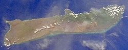
Satellite image of Molokaʻi.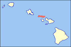
Location in the state of Hawaiʻi.Geography Location 21°08′N 157°02′W / 21.133°N 157.033°W Area 260 sq mi (673.40 km2) Rank 5th largest Hawaiian Island Highest point Kamakou Max elevation 4,961 ft (1,512 m)[1] Demographics Population 7,404 (as of 2000) Density 28/sq mi (11/km²) Official Insignia Flower Kukui Color ʻŌmaʻomaʻo (green) Molokaʻi or Molokai (
 /ˈmɒləkaɪ/; Hawaiian: [ˈmoloˈkɐʔi]) is an island in the Hawaiian archipelago. It is 38 by 10 miles (61 by 16 km) in size with a land area of 260 square miles (673.40 km2), making it the fifth largest of the main Hawaiian Islands and the 27th largest island in the United States.[2] It lies east of Oʻahu across the 25-mile (40 km) wide Kaiwi Channel and north of Lānaʻi, separated from it by the Kalohi Channel. The lights of Honolulu are visible at night from the west end of Molokaʻi, while nearby Lānaʻi and Maui are clearly visible from anywhere along the south shore of the island.
Molokaʻi is known as the long time residence of Father Damien de Veuster, a Belgian priest and canonized Roman Catholic saint who cared for sufferers of Hansen's Disease, also known as leprosy. Historically, a small north shore colony on Molokaʻi, Kalaupapa, was the place where sufferers of Hansen's Disease where forced into quarantine by the Hawaiian government, but there are no active cases of Hansen's Disease on Molokaʻi today. Those who continue to live in the settlement are patients who chose to stay after the segregation policy was lifted in 1969.[3][4] The first European sailor to visit the island was Captain George Dixon in 1786.
Contents
Geography
 Eastern Molokai with a portion of Kamakou and Molokai Forest Reserve
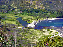 Halawa Bay Beach Park, located at the extreme east end of Molokaʻi
Molokaʻi is built from two distinct shield volcanoes known as East Molokaʻi and the much smaller West Molokaʻi. The highest point is Kamakou on East Molokaʻi, at 4,970 feet (1,510 m). East Molokaʻi volcano, like the Koʻolau Range on Oʻahu, is today only what remains standing of the southern half of the original mountain. The northern half suffered a catastrophic collapse about 1.5 million years ago and now lies as a debris field scattered northward across the Pacific Ocean bottom,[5] while what remains on the island are the highest sea cliffs in the world.[6] Views of these sea cliffs are presented in the movie Jurassic Park III. The south shore of Molokaʻi boasts the longest fringing reef in the U.S. and its holdings—nearly 25 miles (40 km) long.[7]
Molokaʻi is part of the state of Hawaiʻi and located in Maui County, except for the Kalaupapa peninsula, which is separately administered as Kalawao County. Maui County encompasses Maui, Lānaʻi, and Kahoʻolawe in addition to Molokaʻi. The largest town on the island is Kaunakakai, which is one of two small ports on the island. Molokai Airport is located on West Molokaʻi. The United States Census Bureau divides the island into three census tracts: Census Tract 317 and Census Tract 318 of Maui County, Hawaii, and Census Tract 319 of Kalawao County, Hawaii. The total 2000 census population of these was 7,404, living on a land area of 260.02 square miles (673.45 km2).[8] Molokaʻi is separated from Oʻahu on the west by the Kaiwi Channel, from Maui on the southeast by the Pailolo Channel, and from Lānaʻi on the south by the Kalohi Channel.
Ecology
Molokaʻi is split into two main geographical areas. The low western half is very dry and the soil is heavily denuded due to grazing by goats and poor land management practices. It lacks significant ground cover and virtually the entire section is covered in non-native kiawe (Prosopis pallida) trees. One of the few natural areas remaining almost intact are the coastal dunes of Moʻomomi, which are part of a Nature Conservancy preserve.
The eastern half of the island is a high plateau rising up to an elevation of 4,900 ft (1,500 m) on Kamakou peak and includes the 2,774 acres (11.23 km2; 4.334 sq mi) Molokai Forest Reserve.[9] The eastern half is covered with lush wet forests that get over 300 in (7,600 mm) of rain per year. The high elevation forests are populated by native ʻōhiʻa lehua (Metrosideros polymorpha) trees and an extremely diverse endemic flora and fauna in the understory. Much of the summit area is protected by the Nature Conservancy's Kamakou and Pelekunu valley preserves. Below 4,000 feet (1,200 m), the vegetation is dominated by exotic flora, including strawberry guava (Psidium littorale), eucalyptus (Eucalyptus spp.), and cypress (Cupressus spp.). Introduced axis deer (Axis axis) and feral pigs (Sus scrofa) roam native forests, destroying native plants, expanding exotic plants through disturbance and distribution of their seeds, and threatening endemic insects. Near the summit of Kamakou is the unique Pepeʻopae bog, where dwarf ʻōhiʻa and other plants cover the soggy ground.
Molokaʻi is home to a great number of endemic plant and animal species. However, many of its species, including the olomaʻo (Myadestes lanaiensis), kākāwahie (Paroreomyza flammea), and the Molokaʻi ʻŌʻō (Moho bishopi) have become extinct. Molokaʻi is home to a wingless fly among many other endemic insects.
Tourism
 Sign greeting visitors to Molokaʻi at exit to Molokai Airport
For years residents of Molokaʻi have resisted attempts to dramatically increase tourism.[10] Community members successfully opposed the development company Molokai Ranch's attempt to expand through the "Save La'au Point" movement.[11] As a result, on March 24, 2008 what was then the island's largest employer decided to shut all operations including hotels, movie theater, restaurants, and golf course and dismissing 120 workers.[12] Molokaʻi has Hawaiʻi's highest unemployment rate.[13]
National Geographic Traveler magazine and the National Geographic Center for Sustainable Destinations conduct annual Destination Scorecard surveys, aided by George Washington University. In 2007, a panel of 522 experts in sustainable tourism and destination stewardship reviewed 111 selected human-inhabited islands and archipelagos around the world. Molokaʻi ranked 10th among the 111. The survey cited Molokaʻi's pristine, breathtaking tropical landscape, environmental stewardship, rich and deep Hawaiian traditions (the island's mana), and visitor-friendly culture.
The island of Hawaiʻi, Kauaʻi, Maui and Oʻahu, ranked 50, 61, 81 and 104, respectively. Tahiti ranked 57.[14]
Towns and villages
See also
- Alii Aimoku of Molokai
- Father Damien of Molokai
- Ke `Aupuni Lokahi
- National Register of Historic Places listings in Hawaii#Molokai
References
- ^ "Table 5.11 - Elevations of Major Summits". 2004 State of Hawaii Data Book. State of Hawaii. 2004. http://www.hawaii.gov/dbedt/info/economic/databook/db2004/section05.pdf. Retrieved 2007-07-23.
- ^ "Table 5.08 - Land Area of Islands: 2000". 2004 State of Hawaii Data Book. State of Hawaii. 2004. http://www.hawaii.gov/dbedt/info/economic/databook/db2004/section05.pdf. Retrieved 2007-07-23.
- ^ "Kalaupapa National Historical Park - Hansen's Disease Patients at Kalawao and Kalaupapa (U.S. National Park Service)." U.S. National Park Service - Experience Your America. Web. 19 Nov. 2009.
- ^ "Kalaupapa, Molokai, Hawaii - Father Damien". VisitMolokai.com web site. http://visitmolokai.com/kala.html. Retrieved 2009-09-29.
- ^ Hawaiian landslides have been catastrophic, Monterey Bay Aquarium Research Institute
- ^ Culliney, John L. (2006) Islands in a Far Sea: The Fate of Nature in Hawaii. Honolulu: University of Hawaii Press. p. 17.
- ^ http://bulletin.geoscienceworld.org/cgi/content/abstract/115/11/1344 Quantitative morphology of a fringing reef tract from high-resolution laser bathymetry: Southern Molokai, Hawaii
- ^ Census Tracts 317 and 318, Maui County; and Census Tract 319, Kalawao County United States Census Bureau
- ^ Molokai Forest Reserve — Department of Land and Natural Resources
- ^ . http://www.mauinews.com/page/content.detail/id/517428.html.
- ^ http://archives.starbulletin.com/2007/01/14/business/story01.html
- ^ http://www.mauinews.com/page/content.detail/id/517428.html
- ^ http://www.hawaiireporter.com/hawaii-unemployment-at-two-year-low/123
- ^ Tourtellot, Jonathan B. (November/December 2007). "Destinations Rated: Islands". National Geographic Traveler: 108–127. http://traveler.nationalgeographic.com/2007/11/nd07placesratedislands.pdf.
Further reading
- Coffman, Tom (2003). The Island Edge of America: A Political History of Hawai'i. University of Hawaii Press. ISBN 0824826620.
- Engledow, Jill (March 2007). "Where Tradition Holds Sway". Maui Nō Ka ʻOi Magazine 11 (2). http://www.nokaoimagazine.com/Features/v.11n.2/Where_Tradition_Holds_Sway.html. Article about traditional hula halau on Molokaʻi
- Farber, Joseph M (1997) Ancient Hawaiian fishponds: can restoration succeed on Molokaʻi? Cornell University. ISBN 9780965978200.
- Lee, Pali Jae, and Koko Willis (1987). Tales from the Night Rainbow: The Story of a Woman, a People, and an Island. Night Rainbow Publishing. ISBN 0962803006. http://www.amazon.com/Tales-Night-Rainbow-Koko-Willis/dp/0962803006/ref=sr_1_1?s=books&ie=UTF8&qid=1298315568&sr=1-1.
- Lo, Catharine (December/January 2007). "On the Rocks". Hana Hou! 9 (6). http://www.hanahou.com/pages/magazine.asp?Action=DrawArticle&ArticleID=526&MagazineID=33. Article about Hawaiian limpets, a traditional delicacy known locally as ʻopihi.
- Tayman, John (2006). The Colony: The Harrowing True Story of the Exiles of Molokai. Scribners. ISBN 074323300X.
External links
- Official Molokaʻi Visitors Association website
- The Molokaʻi Dispatch weekly print community newspaper.
 State of Hawaii
Honolulu (capital) Topics Geography · Government · Delegations · History · Islands · Music · Language · People · Visitor Attractions
Society Main Islands Northwestern
IslandsFrench Frigate Shoals · Gardner · Kure · Laysan · Lisianski · Maro Reef · Necker · Nihoa · Pearl and Hermes
Communities Counties Categories:- Kalawao County, Hawaii
- Maui County, Hawaii
- Islands of Hawaii
- Molokai


Wikimedia Foundation. 2010.