- North Jakarta
-
City of North Jakarta
Kota Administrasi Jakarta Utara— City (Kota Administrasi) — The city hall of North Jakarta.

Country  Indonesia
Province DKI Jakarta Government - Mayor Effendi Anas Area - Total 146.66 km2 (56.6 sq mi) Population (2010 Census) - Total 1,645,312 - Density 11,218.5/km2 (29,055.9/sq mi) Time zone WIB (UTC+7) Website utara.jakarta.go.id North Jakarta (Indonesian: Jakarta Utara) is one of the five cities (kota) of Jakarta, Indonesia. North Jakarta contains the entire coastal area within Jakarta Special District. In North Jakarta, an area at the estuary of Ciliwung river was the main port for the kingdom of Tarumanegara, which will later grows to become Jakarta. Many historic sites and artefacts of Jakarta can be found in North Jakarta. Both ports of Tanjung Priok and the historic Sunda Kelapa are located in the city. The city, which had 1,645,312 inhabitants at the 2010 Cenus, has its administrative centre in Tanjung Priok.
North Jakarta contains some of Jakarta original nature, the mangrove forest. As the city develop, some of this mangrove forest has been converted into urban areas. However, a reforestation project aims at planting mangroves within an area of 400 hectares has already being enacted, scheduled to be finished in 2012. The main goal of the project is to minimized abrasion in the coastal area, especially around the Pantai Indah Kapuk area.[1]
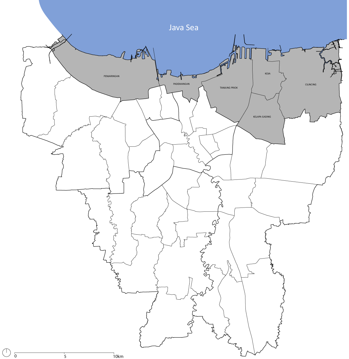
North Jakarta is bounded by Java Sea to the north; Bekasi to the east; West Jakarta, Central Jakarta and East Jakarta to the south; and Tangerang to the west.
Contents
History
The city of Jakarta grows from the area in what is now North Jakarta. In the 5th century, at the mouth of the Ciliwung-Angke River, grew the port city Sundapura (now near Tugu, Jakarta and Bekasi), which is the main port for the Kingdom of Tarumanegara under the leadership of King Mulawarman.
During the 16th century, the city, which covers only the area of what is now North Jakarta, was known as Jayakarta. The system of government in Jayakarta has been amended several times, including change of rulers, and change of the administrative area. This area consists of three forms of government: First, the city government which is controlled directly by the Lord of Jayakarta (the area of which is located in what is now the Port of Angke). Second, the state government controlled by leaders inferior to the Lord of Jayakarta (the area of which is located in what is now Pasar Ikan and Kota. Third, the worldwide government (the area of which is located in what is now Tanjung Priok.
At the beginning of the 17th century, the area was controlled by Chinese and other native people who later have to submit to the Dutch East Indies.
In 1854, the Law of Comptabuliteit 1854 divided the Jakarta Bay area into three categories: the Voorsteden (the suburbs), Regentschap Batavia (the Regency of Batavia) and private areas (supervised by the Department of Security - Afdeling I)
Government system changed again in 1905. After the formation of Gemeente Batavia, the area around Jakarta Bay is transformed into Batavia District which includes the Onderdistrict (Subdistrict) of Penjaringan, Tanjung Priok, Meester Cornelis and Bekasi. Meanwhile, Tanjung Priok is controlled by Haven Directie Koninklijke Paketvaart-Maatschappij.
When Japan entered into the region, the form of the government changed into Shiku (district level), and so North Jakarta was divided into districts such as Shiku Penjaringan, Shiku Tanjung Priok and Shiku Bekasi.
After the formation of the Unitary Republic of Indonesia on August 17, 1945, Jakarta Bay is divided into several administrative regions, namely Kewedanan Penjaringan, Tanjung Priok and Bekasi. These three kawedanan are controlled by the Mayor of Jakarta Raya, which was part of West Java.
In 1957, after the formation of the Kotapraja Jakarta Raya, the area of Jakarta Bay was transformed into the Kotamadya of Jakarta Utara or "City of North Jakarta". [2]
Tourism
The government of North Jakarta planned for a rehabilitation of tourism in North Jakarta under the project of 12 Coastal Tourism of North Jakarta (Indonesian: 12 Jalur Destinasi - Wisata Pesisir Jakarta Utara[3][4]). The chosen 12 destinations are:
- Taman Margasatwa Muara Angke (Muara Angke Wildlife Sanctuary)
- Sentra Perikanan Muara Angke (Muara Angke Fishing Port)
- Pelabuhan Sunda Kelapa (Sunda Kelapa Harbor)
- Masjid Luar Batang (Luar Batang Mosque)
- Sentra Belanja Mangga Dua (Mangga Dua shopping center)
- Taman Impian Jaya Ancol
- Bahtera Jaya
- Stasiun Kereta Api Tanjung Priok (Tanjung Priok Station)
- Jakarta Islamic Center
- Cagar Budaya Rumah Si Pitung dan Masjid Al Alam (Si Pitung's House and Al Alam Mosque)
- Gereja Tugu (Tugu Church)
- Sentra Belanja Kelapa Gading (Kelapa Gading shopping center)
Subdistricts
North Jakarta is subdivided into 6 subdistricts:
References
- ^ iast (February 19, 2011). "2 Juta Mangrove untuk Pesisir Jakarta" (in Indonesian). id.wisatapesisir.com. http://id.wisatapesisir.com/taman-suaka-marga-satwa/995-2-juta-mangrove-untuk-pesisir-jakarta. Retrieved February 26, 2011.
- ^ "Kota Jakarta Utara" (in Indonesian). IANN News. Manan Foundation. http://iannnews.com/ensiklopedia.php?prov=31&kota=457. Retrieved February 26, 2011.
- ^ "Wisata Pesisir" (in Indonesian). Pemerintah Kota Administrasi Jakarta Utara. http://www.jakarta-utara.com/gov/modules/news/index.php?storytopic=5. Retrieved June 2, 2011.
- ^ http://www.desamodern.com+(February 10, 2011). "WISATA PESISIR : 12 TUJUAN WISATA JAKARTA UTARA" (in Indonesian). Portal Berita Universitas Pancasila. http://berita.univpancasila.ac.id/berita-2711-wisata-pesisir--12-tujuan-wisata-jakarta-utara.html. Retrieved June 2, 2011.
External links
- (Indonesian) Official site

Tangerang Regency Jakarta Bay Bekasi Regency Tangerang (city) 
Bekasi Regency, Bekasi (city)  North Jakarta

West Jakarta Central Jakarta East Jakarta Subdistricts of North Jakarta Administrative areas of the Special Capital Territory of Jakarta Cities and Regency of Jakarta Central Jakarta Cempaka Putih • Gambir • Johar Baru • Kemayoran • Menteng • Sawah Besar • Senen • Tanah Abang
West Jakarta Cengkareng • Grogol • Kalideres • Kebon Jeruk • Kembangan • Palmerah • Taman Sari • Tambora
South Jakarta Cilandak • Jagakarsa • Kebayoran Baru • Kebayoran Lama • Mampang Prapatan • Pancoran • Pasar Minggu • Pesanggrahan • Setiabudi • Tebet
East Jakarta Cakung • Cipayung • Ciracas • Duren Sawit • Jatinegara • Kramat Jati • Makasar • Matraman • Pasar Rebo • Pulo Gadung
North Jakarta Cilincing • Kelapa Gading • Koja • Pademangan • Penjaringan • Tanjung Priok
Thousand Islands See also: List of regencies and cities of Indonesia Categories:- Areas of Jakarta
- Jakarta geography stubs

Wikimedia Foundation. 2010.