- Chatswood West, New South Wales
-
Chatswood West
Sydney, New South Wales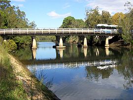
Fullers Bridge, Chatswood WestPopulation: 7,776(2006)[1] Postcode: 2067 Area: 2.8 km² (1.1 sq mi) Location: 10 km (6 mi) north-west of Sydney CBD LGA: City of Willoughby, City of Ryde State District: Lane Cove, Willoughby Federal Division: Bennelong, Bradfield, North Sydney Suburbs around Chatswood West: Macquarie Park Lindfield Roseville North Ryde Chatswood West Chatswood Lane Cove West Lane Cove Artarmon Chatswood West is a suburb on the lower North Shore of Sydney, in the state of New South Wales, Australia. Chatswood West is located 11 kilometres north-west of the Sydney central business district, in the local government areas of the City of Willoughby and the City of Ryde on the western shore of the Lane Cove River. Chatswood is a separate suburb.
Chatswood West is located west of the Pacific Highway, extending from Mowbray Road in the south to Wyvern Avenue in the north, and the Lane Cove River in the west.
Contents
History
Chatswood is believed to be named after the pet name "Chat" of the second wife of Richard Harnett (a pioneer of the district) and the original "wooded" nature of the area.[2]
Commercial area
Chatswood West is mainly residential, with some commercial and office buildings on the Pacific Highway and small commercial areas on Fullers Road and Mowbray Road. The National Acoustics Laboratories is on Greville Street.
Houses
The residential buildings are mainly single dwellings on small blocks of land, however, there has been a rise in the number of blocks of apartments and dual residencies, with an increase in demand for accommodation in this area.
Schools
Chatswood High School and Chatswood Public School are both situated in Chatswood West, within walking distance of Chatswood Station.
Transport
There are regular buses that connect the area with the Chatswood CBD, and other suburbs such as Parramatta. Chatswood railway station is on the North Shore Line of the CityRail network.
Notable residents
- Kenneth Slessor - poet
- Roger Woodward - pianist, lived at Peckham Street
Parks
There are a number of parks, walking tracks and a golf course. There are two entrances to Lane Cove National Park from Chatswood West, one on Lady Game Drive, and one on Delhi Road, next to Fullers Bridge.
Noteworthy indigenous flora includes the Blackbutt, Tree Heath, Celery Wood, Coachwood, Native Crabapple, Hard Corkwood, Filmy Fern and Necklace Fern.
Fauna includes Powerful Owl, Barking Owl, Australian King Parrot, Brush Turkey, Eastern Whipbird, Satin Bowerbird, Eastern Water Dragon, Emerald Spotted Frog, Enamelled Spider, Red triangle slug, Blue Planarian, Long-nosed Bandicoot and marsupial mouse.
-

Crossing of Swaines Creek, Chatswood West
-

Coachwood - Ferndale Park
-

Forest Scene - Ferndale Park
-

Tributary of Swaines Creek
-

Large Blackbutt - Ferndale Park
-

Coachwood Rainforest - Ferndale Park
-

Lilli Pilli Rainforest - Ferndale Park
-

Hawkesbury sandstone & the Rock Felt Fern, Pyrrosia rupestris
References
- ^ "2006 Census Community Profile Series : Chatswood West (State Suburb)". Australian Bureau of Statistics. Accessed 14 October 2009.
- ^ The Book of Sydney Suburbs, Compiled by Frances Pollon, Angus & Robertson Publishers, 1990, Published in Australia ISBN 0-207-14495-8, page 59
Coordinates: 33°48′08″S 151°09′47″E / 33.80210°S 151.16301°E
Categories:- Suburbs of Sydney


Wikimedia Foundation. 2010.