- Geography of Namibia
-
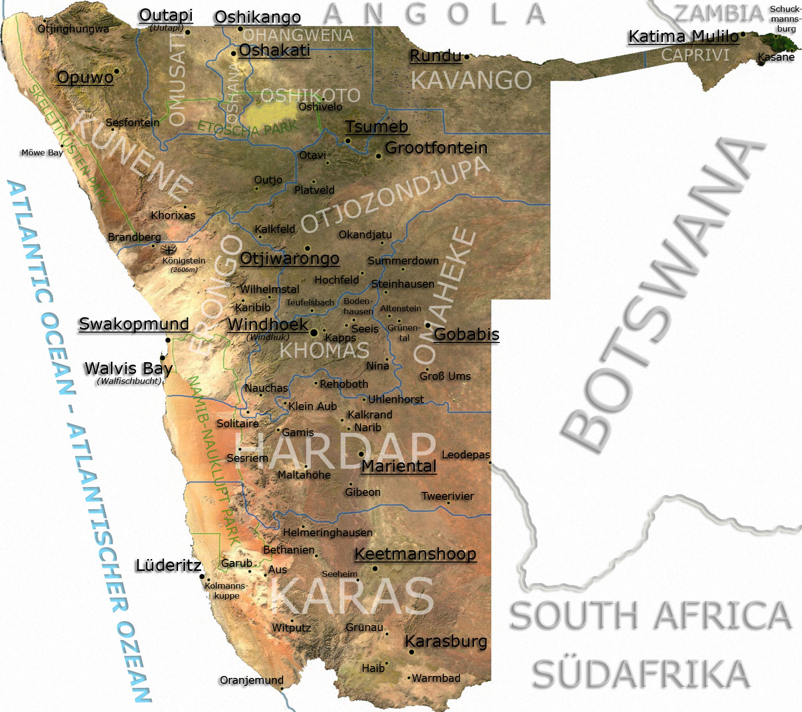
 Detailed map of Namibia based on the radar map shown below.
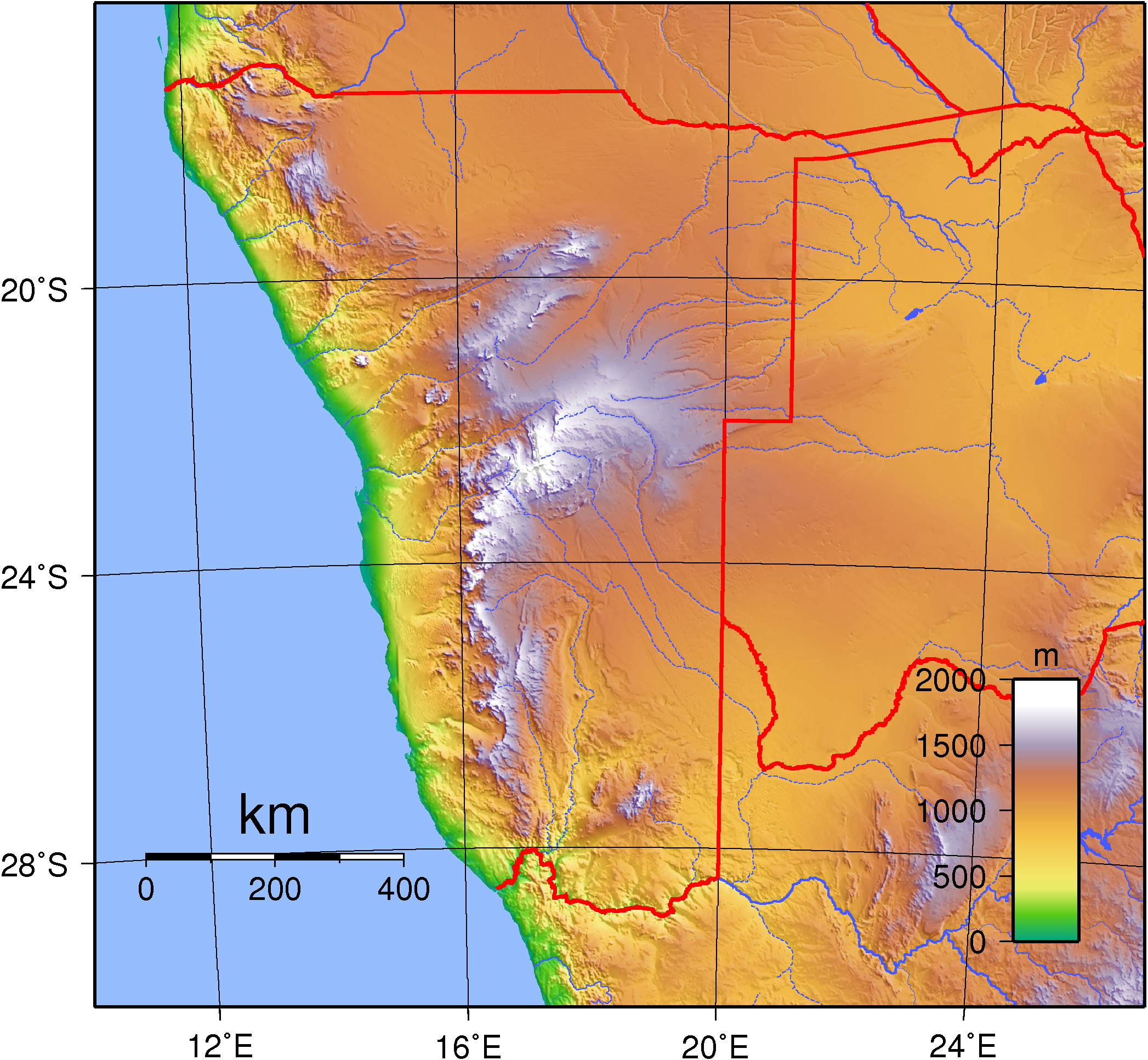
 Topographic map of Namibia.
At 825,418 km2 (318,696 sq mi),[1] Namibia is the world's thirty-fourth largest country (after Venezuela). After Mongolia, Namibia is the least densely populated country in the world (2.5 inhabitants per square kilometre (6.5 /sq mi)).
Contents
Geographical areas
The Namibian landscape consists generally of five geographical areas, each with characteristic abiotic conditions and vegetation with some variation within and overlap between them: the Central Plateau, the Namib Desert, the Great Escarpment, the Bushveld, and the Kalahari Desert.
Central Plateau
The Central Plateau runs from north to south, bordered by the Skeleton Coast to the northwest, the Namib Desert and its coastal plains to the southwest, the Orange River to the south, and the Kalahari Desert to the east. The Central Plateau is home to the highest point in Namibia at Königstein elevation 2,606 meters (8,550 ft).[2] Within the wide, flat Central Plateau is the majority of Namibia’s population and economic activity. Windhoek, the nation’s capital, is located here, as well as most of the arable land. Although arable land accounts for only 1% of Namibia, nearly half of the population is employed in agriculture.[3]
The abiotic conditions here are similar to those found along the Escarpment; however the topographic complexity is reduced. Summer temperatures in the area can reach 40 °C (104 °F), and frosts are common in the winter.
Namib Desert
The Namib Desert is a broad expanse of hyper-arid gravel plains and dunes that stretches along the entire coastline, which varies in width between 100 to many hundreds of kilometres. Areas within the Namib include the Skeleton Coast and the Kaokoveld in the north and the extensive Namib Sand Sea along the central coast.[4] The sands that make up the sand sea are a consequence of erosional processes that take place within the Orange River valley and areas further to the south. As sand-laden waters drop their suspended loads into the Atlantic, onshore currents deposit them along the shore. The prevailing south west winds then pick up and redeposit the sand in the form of massive dunes in the widespread sand sea, the largest sand dunes in the world. In areas where the supply of sand is reduced because of the inability of the sand to cross riverbeds, the winds also scour the land to form large gravel plains. In many areas within the Namib Desert, there is little vegetation with the exception of lichens found in the gravel plains, and in dry river beds where plants can access subterranean water.
Great Escarpment
The Great Escarpment swiftly rises to over 2,000 meters (6,562 ft). Average temperatures and temperature ranges increase as you move further inland from the cold Atlantic waters, while the lingering coastal fogs slowly diminish. Although the area is rocky with poorly developed soils, it is nonetheless significantly more productive than the Namib Desert. As summer winds are forced over the Escarpment, moisture is extracted as precipitation.[5] The water, along with rapidly changing topography, is responsible for the creation of microhabitats which offer a wide range of organisms, many of them endemic. Vegetation along the escarpment varies in both form and density, with community structure ranging from dense woodlands to more shrubby areas with scattered trees. A number of Acacia species are found here, as well as grasses and other shrubby vegetation.
Bushveld
The Bushveld is found in north eastern Namibia along the Angolan border and in the Caprivi Strip which is the vestige of a narrow corridor demarcated for the German Empire to access the Zambezi River. The area receives a significantly greater amount of precipitation than the rest of the country, averaging around 400 mm (15.7 in) per year. Temperatures are also cooler and more moderate, with approximate seasonal variations of between 10 and 30 °C (50 and 86 °F). The area is generally flat and the soils sandy, limiting their ability to retain water.[6] Located adjacent to the Bushveld in north-central Namibia is one of nature’s most spectacular features: the Etosha Pan. For most of the year it is a dry, saline wasteland, but during the wet season, it forms a shallow lake covering more than 6,000 square kilometres (2,317 sq mi). The area is ecologically important and vital to the huge numbers of birds and animals from the surrounding savannah that gather in the region as summer drought forces them to the scattered waterholes that ring the pan. The Bushveld area has been demarcated by the World Wildlife Fund as part of the Angolan Mopane woodlands ecoregion, which extends north across the Cunene River into neighbouring Angola.
Kalahari Desert
The Kalahari Desert is perhaps Namibia’s best known geographical feature. Shared with South Africa and Botswana, it has a variety of localized environments ranging from hyper-arid sandy desert, to areas that seem to defy the common definition of desert. One of these areas, known as the Succulent Karoo, is home to over 5,000 species of plants, nearly half of them endemic; fully one third of the world’s succulents are found in the Karoo.
The reason behind this high productivity and endemism may be the relatively stable nature of precipitation.[7] The Karoo apparently does not experience drought on a regular basis, so even though the area is technically desert, regular winter rains provide enough moisture to support the region’s interesting plant community. Another feature of the Kalahari, indeed many parts of Namibia, are inselbergs, isolated mountains that create microclimates and habitat for organisms not adapted to life in the surrounding desert matrix.
Coastal Desert
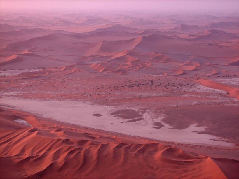
Namibia’s Coastal Desert is one of the oldest deserts in the world. Its sand dunes, created by the strong onshore winds, are the highest in the world.[8]
The Namib Desert and the Namib-Naukluft National Park is located here. The Namibian coastal deserts are the richest source of diamonds on earth, making Namibia the world's largest producer of diamonds. It is divided into the northern Skeleton Coast and the southern Diamond Coast. Because of the location of the shoreline—at the point where the Atlantic's cold water reach Africa—there is often extremely dense fog.[9]
Sandy beach comprises 54% and mixed sand and rock add another 28%. Only 16% of the total length is rocky shoreline. The coastal plains are dune fields, gravel plains covered with lichen and some scattered salt pans. Near the coast there are areas where the dunes are vegetated with hammocks.[10] Namibia has rich coastal and marine resources that remain largely unexplored.[11]
-

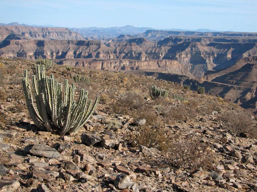
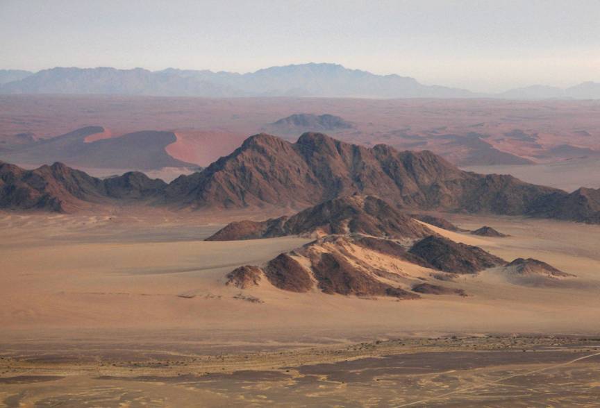
Namib Escarpment.
-

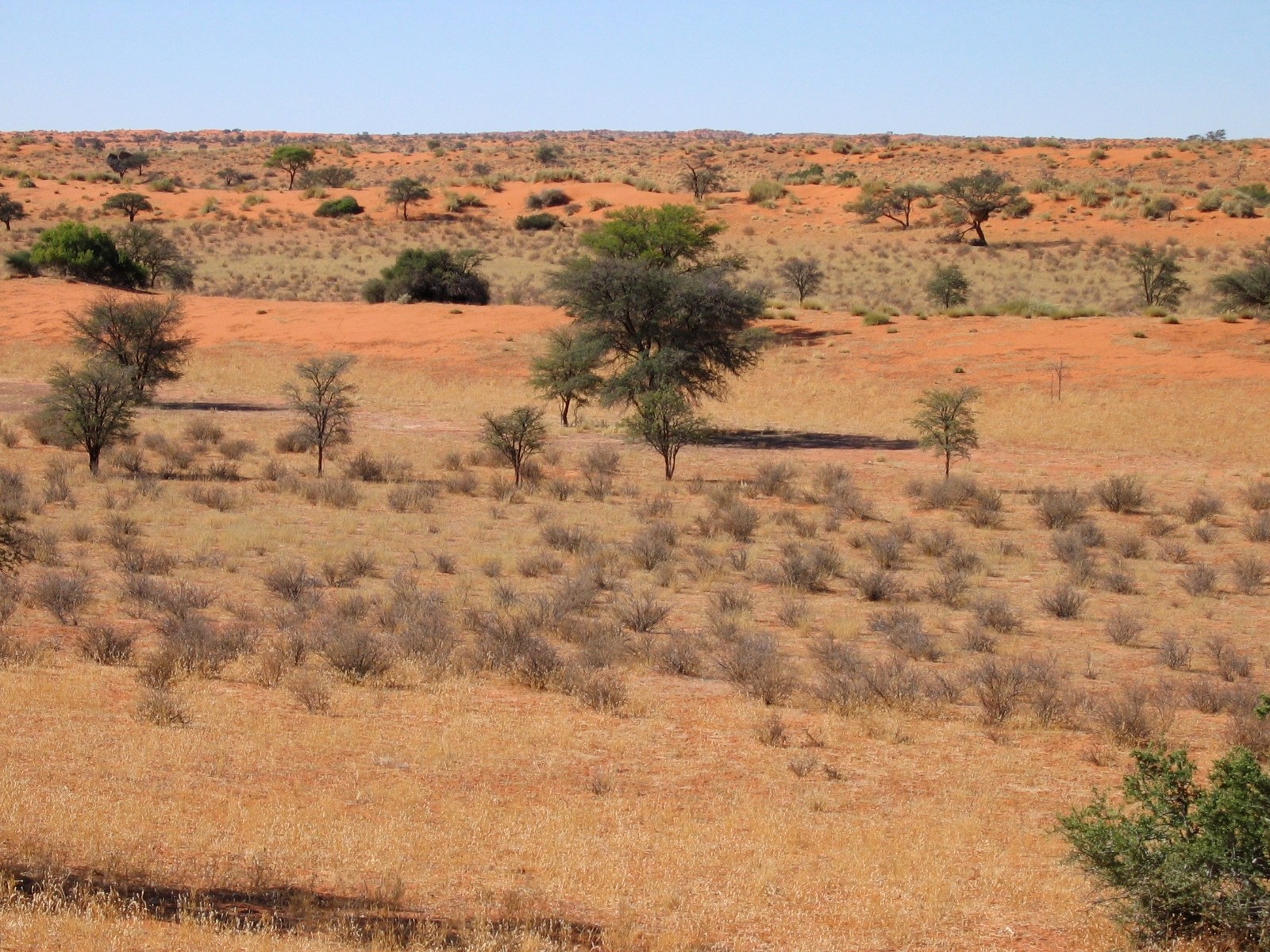
The Kalahari Desert.
-

Windhoek skyline.
-

Natural-colour satellite image of the Namibian coast.
Weather and climate
Namibia has more than 300 days of sunshine per year. It is situated at the southern edge of the tropics; the Tropic of Capricorn cuts the country about in half. The winter (June - August) is generally dry, both rainy seasons occur in summer, the small rainy season between September and November, the big one between February and April.[12] Humidity is low, and average rainfall varies from almost zero in the coastal desert to more than 600 mm in the Caprivi Strip. Rainfall is however highly variable, and droughts are common.[13] The last[update] bad rainy season occurred in summer 2006/07.[14]
Weather and climate in the coastal area are dominated by the cold, north-flowing Benguela current of the Atlantic Ocean which accounts for very low precipitation (50 mm per year or less), frequent dense fog, and overall lower temperatures than in the rest of the country.[13] In Winter, occasionally a condition known as Bergwind or Oosweer (Afrikaans: East weather) occurs, a hot dry wind blowing from the inland to the coast. As the area behind the coast is a desert, these winds can develop into sand storms with sand deposits in the Atlantic Ocean visible on satellite images.[15]
The Central Plateau and Kalahari areas have wide diurnal temperature ranges of up to 30C.[13]
Urbanisation
 Main article: Towns in Namibia
The capital and largest city, Windhoek, is in the centre of the country. It is home to the country's Central Administrative Region, Windhoek Hosea Kutako International Airport and the country's railhead. Other important towns are:
- Arandis, uranium mine
- Walvis Bay, sea port, international airport, railhead
- Oshakati, main business centre in the North, railhead
- Otjiwarongo, main business centre in Central-North, rail junction
- Lüderitz, sea port, railhead
- Gobabis, farming centre
- Keetmanshoop, railhead
- Tsumeb, mining
- Swakopmund, Tourism (Ex German Colonial town)
- Rundu,
- Katima Mulilo
Statistics
Location: Southern Africa, bordering the South Atlantic Ocean, between Angola and South Africa
Geographic coordinates: 22°00′S 17°00′E / 22°S 17°E
Map references: Africa
Area:
total: 825 418 km²
land: 825 418 km²
water: 0 km²Land boundaries:
total: 3 824 km
border countries: Angola 1 376 km, Botswana 1 360 km, South Africa 855 km, Zambia 233 kmCoastline: 1 572 km
Maritime claims:
contiguous zone: 24 nmi (44.4 km; 27.6 mi)
exclusive economic zone: 200 nmi (370.4 km; 230.2 mi)
territorial sea: 12 nmi (22.2 km; 13.8 mi)Terrain: Mostly high plateau; Namib Desert along coast; Kalahari Desert in east. In the north near the border with Angola there is a flat area that has been designated by the World Wildlife Fund as part of the Angolan Mopane woodlands ecoregion.
Elevation extremes:
lowest point: Atlantic Ocean 0 m
highest point: Königstein 2 573 mNatural resources: diamonds, copper, uranium, gold, lead, tin, lithium, cadmium, zinc, salt, vanadium, natural gas, hydropower, fish
note: suspected deposits of oil, coal, and iron oreLand use:
arable land: 0.99% (1998 est.) 1% (1993 est.)
permanent crops: 0% (1998, 1993 est.)
permanent pastures: 46% (1993 est.)
forests and woodland: 22% (1993 est.)
other: 99.01 (1998 est.), 31% (1993 est.)Irrigated land: 70 km² (1998 est.), 60 km² (1993 est.)
Natural hazards: prolonged periods of drought
Environment - current issues: very limited natural freshwater resources; desertification
Environment - international agreements:
party to: Antarctic-Marine Living Resources, Biodiversity, Climate Change, Desertification, Endangered Species, Hazardous Wastes, Law of the Sea, Ozone Layer Protection, Wetlands
signed, but not ratified: none of the selected agreementsExtreme points
This is a list of the extreme points of Namibia, the points that are farther north, south, east or west than any other location.
- Northern-most point - unnamed location on the border with Angola in the Kunene river immediately west of the Epupa Falls, Kunene Region
- Eastern-most point - the tripoint with Botswana and Zambia, Caprivi Region
- Southern-most point - unnamed location in Pella Drift on the Orange river border with South Africa, Karas Region
- Western-most point - unnamed section of coast west of the Okotuso well, Kunene Region
See also
- Namibia
- Towns in Namibia
- List of rivers of Africa
- Rivers in Namibia
References
- ^ "Rank Order - Area". CIA World Fact Book. https://www.cia.gov/library/publications/the-world-factbook/rankorder/2147rank.html. Retrieved 2008-04-12.
- ^ Landsat.usgs.gov
- ^ World Almanac. 2004.
- ^ Spriggs, A. 2001.(AT1315)
- ^ Spriggs, A. 2001.(AT1316)
- ^ Cowling, S. 2001.
- ^ Spriggs, A. 2001.(AT0709)
- ^ "NASA - Namibia’s Coastal Desert". www.nasa.gov. http://www.nasa.gov/multimedia/imagegallery/image_feature_540.html. Retrieved 2009-10-09.
- ^ "An Introduction to Namibia". www.geographia.com. http://www.geographia.com/namibia/. Retrieved 2009-10-09.
- ^ "NACOMA - Namibian Coast Conservation and Management Project". www.nacoma.org.na. http://www.nacoma.org.na/Our_Coast/WalkOnOurCoastline.htm. Retrieved 2009-10-09.
- ^ Sparks, Donald L.. "Namibia's Coastal and Marine Development Potential -- Sparks 83 (333): 477 -- African Affairs". afraf.oxfordjournals.org. http://afraf.oxfordjournals.org/cgi/pdf_extract/83/333/477. Retrieved 2009-10-09.
- ^ "The Rainy Season". Real Namibia. http://www.realnamibia.com/rn_028rainyseason.htm. Retrieved 28 July 2010.
- ^ a b c "Namibia". Encyclopedia Britannica. http://www.britannica.com/EBchecked/topic/402283/Namibia/43996. Retrieved 28 July 2010.
- ^ Olszewski, John (28 May 2009). "Climate change forces us to recognise new normals". Namibia Economist. http://www.economist.com.na/index.php?option=com_content&view=article&catid=531:weather&id=14308:climate-change-forces-us-to-recognise-new-normals&Itemid=54.
- ^ Olszewski, John (25 June 2010). "Understanding Weather - not predicting it". Namibia Economist. http://www.economist.com.na/index.php?option=com_content&view=category&layout=blog&id=575&Itemid=54&limitstart=5.
Sovereign
states- Algeria
- Angola
- Benin
- Botswana
- Burkina Faso
- Burundi
- Cameroon
- Cape Verde
- Central African Republic
- Chad
- Comoros
- Democratic Republic of the Congo
- Republic of the Congo
- Côte d'Ivoire (Ivory Coast)
- Djibouti
- Egypt
- Equatorial Guinea
- Eritrea
- Ethiopia
- Gabon
- The Gambia
- Ghana
- Guinea
- Guinea-Bissau
- Kenya
- Lesotho
- Liberia
- Libya
- Madagascar
- Malawi
- Mali
- Mauritania
- Mauritius
- Morocco
- Mozambique
- Namibia
- Niger
- Nigeria
- Rwanda
- São Tomé and Príncipe
- Senegal
- Seychelles
- Sierra Leone
- Somalia
- South Africa
- South Sudan
- Sudan
- Swaziland
- Tanzania
- Togo
- Tunisia
- Uganda
- Zambia
- Zimbabwe
States with limited
recognition- Sahrawi Arab Democratic Republic
- Somaliland
Dependencies and
other territories- Canary Islands / Ceuta / Melilla / Plazas de soberanía (Spain)
- Madeira (Portugal)
- Mayotte / Réunion (France)
- Saint Helena / Ascension Island / Tristan da Cunha (United Kingdom)
- Western Sahara
Climate of Africa Sovereign
states- Algeria
- Angola
- Benin
- Botswana
- Burkina Faso
- Burundi
- Cameroon
- Cape Verde
- Central African Republic
- Chad
- Comoros
- Democratic Republic of the Congo
- Republic of the Congo
- Côte d'Ivoire (Ivory Coast)
- Djibouti
- Egypt
- Equatorial Guinea
- Eritrea
- Ethiopia
- Gabon
- The Gambia
- Ghana
- Guinea
- Guinea-Bissau
- Kenya
- Lesotho
- Liberia
- Libya
- Madagascar
- Malawi
- Mali
- Mauritania
- Mauritius
- Morocco
- Mozambique
- Namibia
- Niger
- Nigeria
- Rwanda
- São Tomé and Príncipe
- Senegal
- Seychelles
- Sierra Leone
- Somalia
- South Africa
- South Sudan
- Sudan
- Swaziland
- Tanzania
- Togo
- Tunisia
- Uganda
- Zambia
- Zimbabwe
States with limited
recognition- Sahrawi Arab Democratic Republic
- Somaliland
Dependencies and
other territories- Canary Islands / Ceuta / Melilla / Plazas de soberanía (Spain)
- Madeira (Portugal)
- Mayotte / Réunion (France)
- Saint Helena / Ascension Island / Tristan da Cunha (United Kingdom)
- Western Sahara
Categories:


Wikimedia Foundation. 2010.