- Navassa Island
-
Navassa Island Island  Aerial view of the east coast
 Flag
Flag Symbol
Country United States Parts Lulu Town Location Caribbean Sea Area 5.2 km2 (2 sq mi) Population Uninhabited. Hundreds of laborers lived here while it was being mined Animal Wildlife preserve Material Coral, limestone Easiest access Offshore anchorage only; steep cliffs make boat landing impossible Discovered by Christopher Columbus - date 1504 FIPS bq  Map of Navassa Island
Claimed by Haiti Navassa Island (French: La Navasse, Haitian Kreyòl: Lanavaz or Lavash) is a small, uninhabited island in the Caribbean Sea, claimed as an unorganized unincorporated territory of the United States, which administers it through the U.S. Fish and Wildlife Service. Haiti, which claims to have had[weasel words] sovereignty over Navassa since 1801, also claims the island in its constitution.[1][2][3]
Contents
Geography, topography and ecology
Navassa Island is about 2 square miles (5.2 km2). It is found at a strategic location 90 nautical miles (100 mi; 170 km) south of the U.S. naval base at Guantanamo Bay, Cuba, about one-quarter of the way from Haiti to Jamaica in the Jamaica Channel. It reaches an elevation of 250 feet (76 m) at Dunning Hill 110 yards (100 m) south of the lighthouse, Navassa Island Light. This location is 440 yards (400 m) from the southwestern coast or 655 yards (600 m) east of Lulu Bay. The island's latitude and longitude is 18°24′10″N 75°0′45″W / 18.40278°N 75.0125°WCoordinates: 18°24′10″N 75°0′45″W / 18.40278°N 75.0125°W.
 Navassa Island is south of Cuba, east of Jamaica, and west of Haiti. This map originates with the US government and shows the US claim on the island
 Navassa Island - NASA ISS satellite image
The terrain of Navassa Island consists mostly of exposed coral and limestone, the island being ringed by vertical white cliffs 30 to 50 feet (9.1 to 15.2 m) high, but with enough grassland to support goat herds. The island is covered in a forest of just four tree species: short-leaf fig (Ficus populnea var. brevifolia), pigeon plum (Coccoloba diversifolia), mastic (Sideroxylon foetidissimum) and poisonwood (Metopium brownei).[4][5] Its topography and ecology is similar to that of Mona Island, a small limestone island located in the Mona Passage, between Puerto Rico and the Dominican Republic. It shares historical similarities with Mona Island since both are U.S. territories, were once centers of guano mining, and presently are nature reserves. Transient Haitian fishermen and others camp on the island but the island is otherwise uninhabited.[6] It has no ports or harbors, only offshore anchorages, and its only natural resource is guano; economic activity consists of subsistence fishing and commercial trawling activities.[7]
There were 8 species of native reptiles, all of which are believed to be, or to have been, endemic to Navassa Island: Celestus badius (an anguid lizards), Aristelliger cochranae (a gecko), Sphaerodactylus becki (a gecko), Anolis longiceps (an anole), Cyclura (cornuta) onchiopsis (a rock iguana), Leiocephalus eremitus (a curly-tailed lizard), Tropidophis bucculentus (a dwarf boa), and Typhlops sulcatus (a tiny snake).[8] Of these, the first four remain common, but the last four are likely extinct.[8]
History
In 1504, Christopher Columbus, stranded on Jamaica, sent some crew members by canoe to Hispaniola for help. They ran into the island on the way, but it had no water. They called it Navaza (from "nava-" meaning plain, or field), and it was avoided by mariners for the next 350 years.
Despite an earlier claim by Haiti, Navassa Island was claimed for the United States on September 19, 1857 by Peter Duncan, an American sea captain, under the Guano Islands Act of August 18, 1856: for the rich guano deposits found on the island, and for not being within the lawful jurisdiction of any other government, nor occupied by another government's citizens. Haiti protested the annexation, but on July 7, 1858 U.S. President James Buchanan issued an Executive Order upholding the American claim, which also called for military action to enforce it. Navassa Island has since been maintained by the United States as an unincorporated territory (according to the Insular Cases). The United States Supreme Court on November 24, 1890 in Jones v. United States, 137 U.S. 202 (1890) Id. at 224 found that Navassa Island must be considered as appertaining to the United States, creating a legal history for the island under US law much different than many other islands originally claimed under the Guano Islands Act.
Guano phosphate was a superior organic fertilizer that became a mainstay of American agriculture in the mid-19th century. Duncan transferred his discoverer's rights to his employer, an American guano trader in Jamaica, who sold them to the newly formed Navassa Phosphate Company of Baltimore. After an interruption for the U.S. Civil War, the Company built larger mining facilities on Navassa with barrack housing for 140 black contract laborers from Maryland, houses for white supervisors, a blacksmith shop, warehouses, and a church.[9] Mining began in 1865. The workers dug out the guano by dynamite and pick-axe and hauled it in rail cars to the landing point at Lulu Bay, where it was sacked and lowered onto boats for transfer to the Company barque, the S.S. Romance. The living quarters at Lulu Bay were called Lulu Town, as appears on old maps. Railway tracks eventually extended inland.
Hauling guano by muscle-power in the fierce tropical heat, combined with general disgruntlement with conditions on the island, eventually provoked a rebellion in 1889, in which five supervisors died. A U.S. warship returned eighteen of the workers to Baltimore for three separate trials on murder charges. A black fraternal society, the Order of Galilean Fisherman, raised money to defend the miners in federal court, and the defense built its case on the contention that the men acted in self-defense or in the heat of passion, and that the United States did not have jurisdiction over the island. The cases, including Jones v. United States, 137 U.S. 202 (1890) went to the U.S. Supreme Court in October 1890, which ruled the Guano Act constitutional, and three of the miners were scheduled for execution in the spring of 1891. A grass-roots petition drive by black churches around the country, also signed by white jurors from the three trials, reached President Benjamin Harrison, who commuted the sentences to imprisonment.[10]
Guano mining resumed on Navassa at a much reduced level. The Spanish-American War of 1898 forced the Phosphate Company to evacuate the island and file for bankruptcy, and the new owners abandoned the island after 1901.
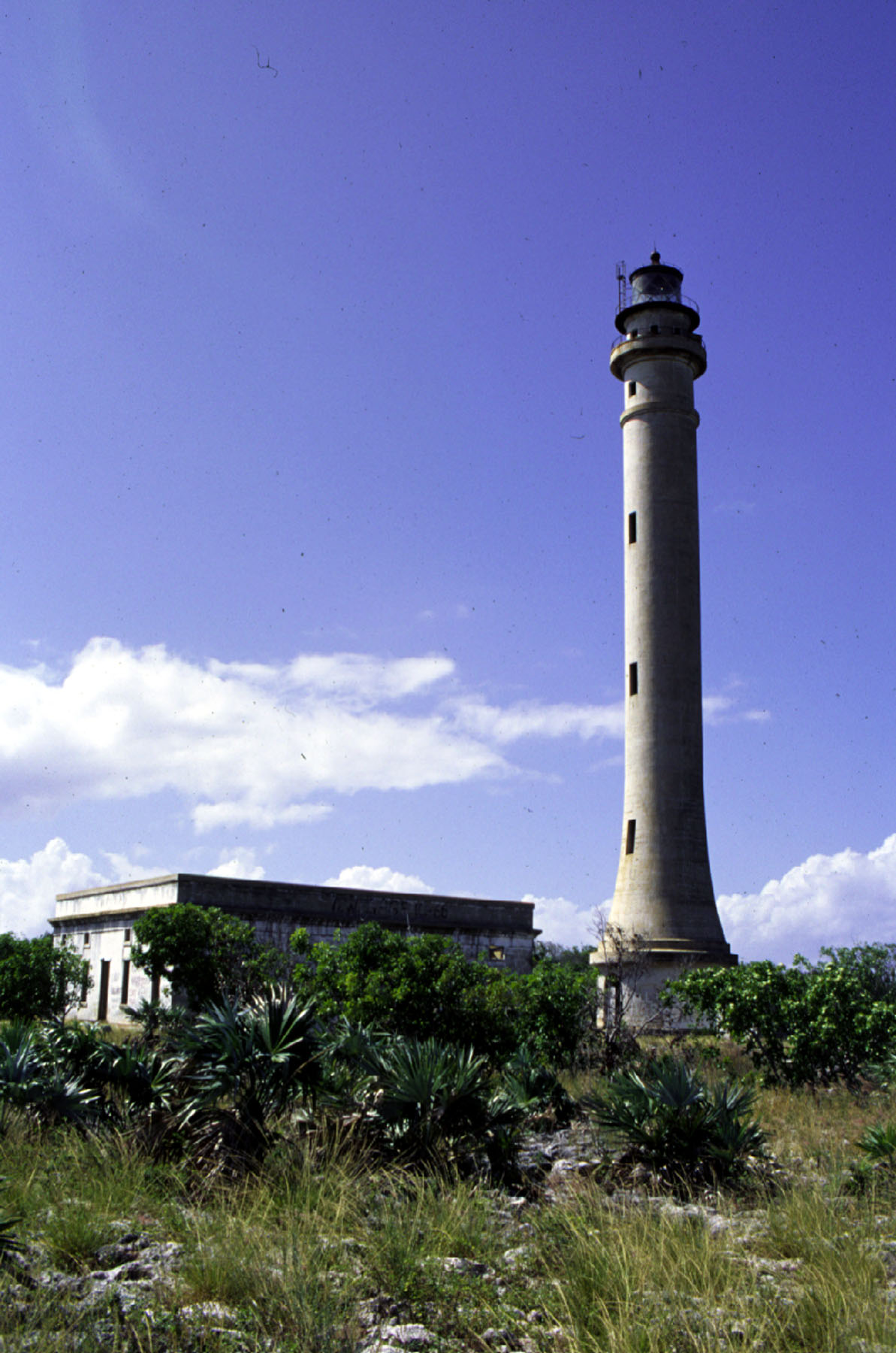
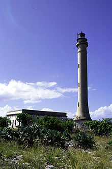 Navassa Island Light. The light keeper's quarters appear in the background.
 Ruins of Navassa Light keeper's quarters.
Navassa became significant again with the opening of the Panama Canal in 1914. Shipping between the American eastern seaboard and the Canal goes through the Windward Passage between Cuba and Haiti. Navassa, a hazard to navigation, needed a lighthouse. The U.S. Lighthouse Service built Navassa Island Light, a 162 foot (46 m) tower on the island in 1917, 395 feet (120 m) above sea level. A keeper and two assistants were assigned to live there until the United States Lighthouse Service installed an automatic beacon in 1929. After absorbing the Lighthouse Service in 1939, the U.S. Coast Guard serviced the light twice each year. The U.S. Navy set up an observation post for the duration of World War II. The island has been uninhabited since then.
A scientific expedition from Harvard University studied the land and marine life of the island in 1930. After World War II amateur radio operators occasionally visited to operate from the territory, which is accorded "entity" (country) status by the American Radio Relay League.[11] The callsign prefix is KP1.[11] Fishermen, mainly from Haiti, fish the waters around Navassa.
 Aerial photo showing the steep rocky coast that rings the island.
From 1903 to 1917, Navassa was a dependency of the U.S. Guantanamo Bay Naval Base, and from 1917 to 1996 it was under United States Coast Guard administration. Since January 16, 1996, it has been administered by U.S. Department of the Interior.
On August 29, 1996, the United States Coast Guard dismantled the light on Navassa. An inter-agency task force headed by the U.S. Department of State transferred oversight of the island to the U.S. Department of the Interior. By Secretary's Order No. 3205 of January 16, 1997, the Interior Department assumed control of the island and placed the island under its Office of Insular Affairs. For statistical purposes, Navassa was grouped with the now-obsolete term United States Miscellaneous Caribbean Islands and is now grouped with other islands claimed by the U.S. under the Guano Islands Act as the United States Minor Outlying Islands.[12]
A 1998 scientific expedition led by the Center for Marine Conservation in Washington D.C. described Navassa as "a unique preserve of Caribbean biodiversity."[7] The island's land and offshore ecosystems have survived the twentieth century virtually untouched.[13]
By Secretary's Order No. 3210 of December 3, 1999, the United States Fish and Wildlife Service assumed administrative responsibility for Navassa, which became a National Wildlife Refuge Overlay, also known as Navassa Island National Wildlife Refuge. The Office of Insular Affairs retains authority for the island's political affairs and judicial authority is exercised directly by the nearest U.S. Circuit Court. Access to Navassa is hazardous and visitors need permission from the Fish and Wildlife Office in Boquerón, Puerto Rico in order to enter its territorial waters or land.[14] Since this change of status, amateur radio operators have repeatedly been denied entry.[11]
Unofficial flag
 Unofficial flag. Flag ratio: 3:5
The unofficial flag of Navassa Island was designed for and first flown at a World War II memorial tribute at the USS Arizona Memorial at Pearl Harbor, Hawaii on December 7, 2001. It is a white and blue horizontal bicolor, with a profile of the island (and its landmark lighthouse, with exaggerated size) in the white band.
See also
Main article: Index of Navassa Island-related articles- Caribbean Sea
- List of Guano Island claims
References
- ^ Government of Haiti: Geography of Haiti (with French to English translation)
- ^ Serge Bellegarde (October 1998). [haitiforever.com/windowsonhaiti/navassa.shtml "Navassa Island: Haiti and the U.S. – A Matter of History and Geography"]. windowsonhaiti.com. haitiforever.com/windowsonhaiti/navassa.shtml. Retrieved 2008-02-06.
- ^ "Haiti: Constitution, 1987 (English translation)". http://www.oas.org/juridico/MLA/en/hti/en_hti-int-const.html.
- ^ Navassa National Wildlife Refuge Wildlife
- ^ Navassa Island:Terrestrial biota
- ^ Navassa Island - NOAA
- ^ a b Navassa Island - World Factbook
- ^ a b Powell, Robert (2003). Reptiles of Navassa Island. Avila University.
- ^ Poop Dreams
- ^ Navassa Island Incident
- ^ a b c ARRL Letter
- ^ Warren v. United States
- ^ SCIENTISTS GIVE GLOWING REPORT OF UNTOUCHED ISLAND
- ^ NOAA History
- Fabio Spadi (2001). "Navassa: Legal Nightmares in a Biological Heaven?". IBRU Boundary & Security Bulletin. http://www.dur.ac.uk/ibru/publications/view/?id=195.
External links
- Wikimedia Atlas of Navassa Island
- Navassa Island travel guide from Wikitravel
- STATE OF NAVAZA
- - Poop Dreams Baltimore City Paper article on history
- Navassa Island profile - OIA
- A photographic tour of Navassa Island - USGS
- Navassa Island World Factbook entry - CIA
- Navassa Island Coral Reefs
- U.S Fish & Wildlife Service: Navassa National Wildlife Refuge
- The Navassa island riot. Illustrated. Published by the National Grand Tabernacle, Order of Galillean Fishermen, Baltimore, Md.
- Warren v. United States
Countries and dependencies of North America Sovereign states - Antigua and Barbuda
- Bahamas
- Barbados
- Belize
- Canada
- Costa Rica
- Cuba
- Dominica
- Dominican Republic
- El Salvador
- France (Guadeloupe · Martinique)
- Grenada
- Guatemala
- Haiti
- Honduras
- Jamaica
- Mexico
- Nicaragua
- Netherlands (Bonaire · Saba · Sint Eustatius)
- Panama
- St. Kitts and Nevis
- Saint Lucia
- St. Vincent and the Grenadines
- Trinidad and Tobago
- United States
Dependencies DenmarkFranceNetherlandsUnited KingdomUnited States- Bajo Nuevo Bank
- Navassa Island
- Puerto Rico
- Serranilla Bank
- U.S. Virgin Islands
Countries and territories of the Caribbean Sovereign states Other republicsDependencies and other areas by parent state United KingdomNetherlandsAruba · Bonaire · Curaçao · Saba · Sint Eustatius · Sint MaartenFranceUnited StatesProtected areas of the United States by political division States - Alabama
- Alaska
- Arizona
- Arkansas
- California
- Colorado
- Connecticut
- Delaware
- Florida
- Georgia
- Hawaii
- Idaho
- Illinois
- Indiana
- Iowa
- Kansas
- Kentucky
- Louisiana
- Maine
- Maryland
- Massachusetts
- Michigan
- Minnesota
- Mississippi
- Missouri
- Montana
- Nebraska
- Nevada
- New Hampshire
- New Jersey
- New Mexico
- New York
- North Carolina
- North Dakota
- Ohio
- Oklahoma
- Oregon
- Pennsylvania
- Rhode Island
- South Carolina
- South Dakota
- Tennessee
- Texas
- Utah
- Vermont
- Virginia
- Washington
- West Virginia
- Wisconsin
- Wyoming
Federal district Insular areas - American Samoa
- Guam
- Northern Mariana Islands
- Puerto Rico
- U.S. Virgin Islands
Outlying islands Midway Atoll · Navassa Island
Pacific Remote Islands Marine National Monument (Baker Island · Howland Island · Jarvis Island · Johnston Atoll · Kingman Reef · Palmyra Atoll · Wake Island)Sovereign states Dependencies and
other territories- Anguilla
- Aruba
- Bermuda
- Bonaire
- British Virgin Islands
- Cayman Islands
- Curaçao
- Greenland
- Guadeloupe
- Martinique
- Montserrat
- Navassa Island
- Puerto Rico
- Saint Barthélemy
- Saint Martin
- Saint Pierre and Miquelon
- Saba
- Sint Eustatius
- Sint Maarten
- Turks and Caicos Islands
- United States Virgin Islands
Climate of North America Sovereign states - Antigua and Barbuda
- Bahamas
- Barbados
- Belize
- Canada
- Costa Rica
- Cuba
- Dominica
- Dominican Republic
- El Salvador
- Grenada
- Guatemala
- Haiti
- Honduras
- Jamaica
- Mexico
- Nicaragua
- Panama
- Saint Kitts and Nevis
- Saint Lucia
- Saint Vincent and the Grenadines
- Trinidad and Tobago
- United States
Dependencies and
other territories- Anguilla
- Aruba
- Bermuda
- Bonaire
- British Virgin Islands
- Cayman Islands
- Curaçao
- Greenland
- Guadeloupe
- Martinique
- Montserrat
- Puerto Rico
- Saint Barthélemy
- Saint Martin
- Saint Pierre and Miquelon
- Saba
- Sint Eustatius
- Sint Maarten
- Turks and Caicos Islands
- United States Virgin Islands
Categories:- Navassa Island
- United States–Caribbean relations
- International territorial disputes of the United States
- Disputed islands
- Islands claimed under the Guano Islands Act
- Former populated places in North America
- Territorial disputes of Haiti
- Uninhabited Caribbean islands of the United States
- Dependent territories in North America


Wikimedia Foundation. 2010.