- Hong Kong tropical cyclone warning signals
-
The Hong Kong tropical cyclone warning signals (Chinese: 熱帶氣旋警告信號) or informally typhoon signals (颱風信號) are a set of signals used to indicate the threat or effects of a tropical cyclone. The Hong Kong Observatory issues the warning signal if a tropical cyclone is centred within 800 kilometres (500 mi) of Hong Kong and may affect Hong Kong later. A very similar system, which is maintained by the Macao Meteorological and Geophysical Bureau, is used in Macau.
The signals are represented as a set of numbers, symbols and lights.
Contents
History
The Hong Kong Observatory began issuing warnings for tropical cyclones in 1884, when it began to monitor and report news of tropical cyclones within the South China Sea, and the areas around Guam and Manila.[1] The monitoring efforts later expanded to gathering information from various seafaring vessels. These works were done in conjunction with the Marine Department until 1886.[1] At first, the monitoring and warning services were geared mainly towards seafarers, and not towards the residents of Hong Kong.[1]
The forefathers of the warning signals that Hong Kong residents are familiar with today began in 1884, when a numerical warning system, consisting of symbols that are a combination of drums, balls, and cones was hoisted at various places in Victoria Harbour.[1] At first, the signals only gave information as to which cardinal direction winds from the tropical cyclone are coming from. Revisions of the system in 1904 added alerts as to which ordinal directions the winds are coming from. Until 1917, there are two sets of warning signals, one signals with black symbols, and one with red. The black symbols indicate that the tropical cyclone in question is less than 300 miles (480 km) from Hong Kong, while the red symbols indicate that the tropical cyclone is over 300 miles (480 km) away from Hong Kong.[1]
The alert system was also supplemented by a custom of firing guns (later cannons and bombs, whose louder sounds were considered an improvement) when a tropical cyclone hits Hong Kong, which was the system most Hong Kong residents at the time rely on for severe weather updates, as a scant few pay attention to the warning system that was intended for seafarers.[1] The frequency of the firing was also an indication of how intense the tropical cyclone was, with three being the indication of a very intense cyclone.[1] This custom ended in 1937, as the local residents began to rely on radio, newspapers, and notices at ferry piers for tropical cyclone information.[1]
A system that partially resembles the modern warning system was devised in 1917, after a meeting in Japan on the unification of cyclone warning standards failed to come to an agreement.[1] Influenced by that meeting, the Observatory reformed its existing system, with the warning consisting of 7 levels (4 of which will ultimately became the 4 no. 8 signals that Hong Kong residents are familiar with today).[1] The system was marketed to other countries along the South China Sea, to no avail. The system was later repurposed for domestic use, but by request from Hong Kong's Chamber of Commerce, another set of warning signals intended for tropical cyclones outside of Hong Kong was also used by the Hong Kong Observatory.[1] The practice of maintaining two distinct set of warning systems, with different purposes, persisted until 1962.
Eventually, through the years, the storm signals deviated from its original purpose of serving mariners, and became a system for the domestic population.[1] The 10-level warning system was eventually slimmed down to the 5 level system that is in use today.
In the past, the signals were physically hoisted at many locations in Hong Kong; there were 42 signal stations around the territory in the 1960s. However, as radio and television weather reports became increasingly effective, the need to hoist physical signals diminished. The last signal station, Cheung Chau aeronautical meteorological station on Cheung Chau, was decommissioned on 1 January 2002. Accordingly, the observatory has replaced the word hoist with issue in its official terminology, although the phrase "Signal No. __ has been hoisted" is still widely used by the public and the mass media. Weather authorities in Macao, however, still use the term "hoisted" when issuing their tropical cyclone warnings, the system of which is based heavily upon Hong Kong's.
Current system
Starting from 1 January 1973, signals 5 to 8 were replaced by 8 NW, 8 SW, 8 NE and 8 SE respectively so as to avoid misunderstanding by the public. This system has been in use ever since.
In accordance with legal codes and common practices in Hong Kong, once any signals higher than No. 3 are issued, all government agencies will shut down their operations. Schools will immediately cease their sessions, as well the financial markets and a majority of the private sector. Public transit agencies that operate on the sea or on surface streets and highways will either cease or scale back their operation. In an effort to minimise the disruptions and stress caused by the exodus of office workers from their workplace, the Hong Kong Observatory usually gives the city an advance warning of about two hours before actually issuing Signal No. 8.
As the system was originally intended to serve as warnings for mariners, the issuance of signals were based on wind speeds measured around the Victoria Harbour. However, the system has also been adopted for use by the public over the years, and with ongoing urbanization, some have come to question the relevance of the warning system's mechanism in this day and age, citing the following reasons:
- The city enters a complete standstill once Signal No. 8 is issued, and economic losses are incurred as a result of disruptions to financial activities.
- An overwhelming majority of buildings in Hong Kong are now built using concrete, and thus are able to withstand substantially higher wind speeds.
- With many tall skyscrapers acting as barriers, wind speeds are slowed, thus minimising the danger that citizens are exposed to.
- The advent of Mass Transit Railway (MTR) has allowed transportation to operate underground, free from weather interferences.
- After being released from work due to an impending storm, many officeworkers treat their time off as an opportunity to go out and socialize, as evident by full restaurants and queues outside cinemas, rather than to go home and ride out the storm, exemplifying the trust Hong Kongers have in the city's storm defenses.
Starting from the tropical cyclone season in 2007, the signals are issued based on a network of 8 near sea-level reference anemometers over Hong Kong.
Meaning of signals
The Saffir–Simpson Hurricane Scale, also referred to as the Saffir–Simpson Hurricane Wind Scale, is a classification used for some Western Hemisphere tropical cyclones. However Hong Kong has a similar five level official definitions of the signals as shown in the table below.
The highest level, No. 10, is rarely issued. As of 22 September 2011, there have been only twelve No. 10 warnings in the last 65 years, and only one in the last 28 years (Typhoon York in 1999). [2]
Signal
NumberSignal
NameSustained Wind Speed
(km/h, (mph, Beaufort scale))Gusts
(km/h (mph))Signal
SignLight Signal
(Abolished)Remarks 1
Stand-by (戒備)
N/A
N/A

White
White
WhiteA tropical cyclone is centred within 800 kilometres of Hong Kong and may later affect the territory, or there are strong winds in Hong Kong waters 3
Strong winds (強風)
41 - 62 (26-37, Beaufort Force 6-7)
may exceed 110 (69)

Green
White
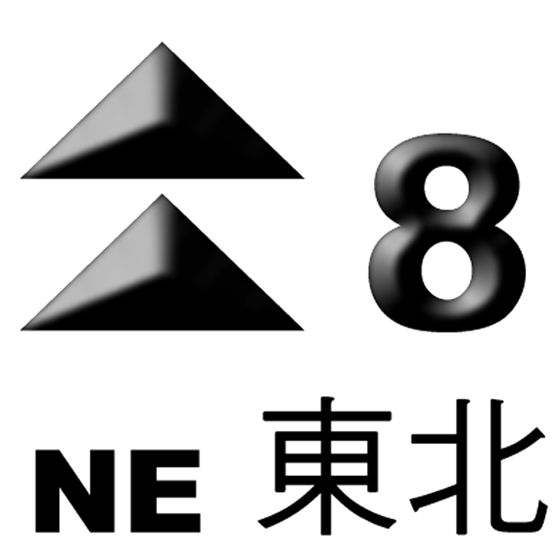
GreenStrong winds are expected or blowing generally in Hong Kong near the sea level, and the wind condition is expected to persist 8 NE
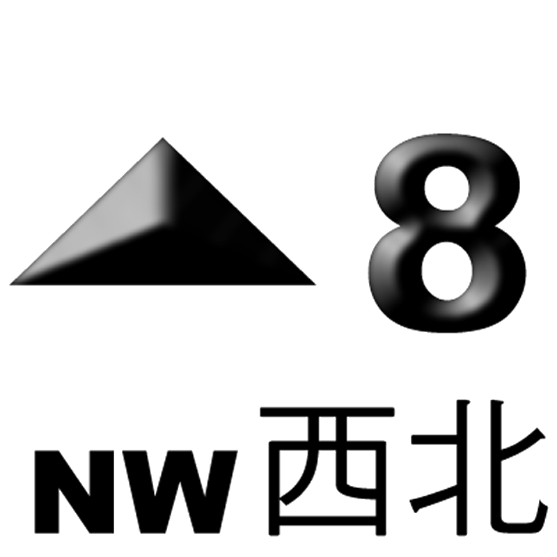
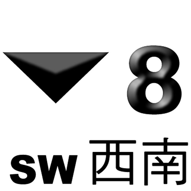
Gale or storm force winds
(烈風或暴風)63 - 117 (38-73, Beaufort Force 8-11)
may exceed 180 (113)

Green
Green
WhiteGale or storm force winds are expected or blowing generally in Hong Kong near the sea level from the NW quadrant, and the wind condition is expected to persist 8 NW

White
Green
GreenGale or storm force winds are expected or blowing generally in Hong Kong near the sea level from the NE quadrant, and the wind condition is expected to persist 8 SE

White
White
GreenGale or storm force winds are expected or blowing generally in Hong Kong near the sea level from the SE quadrant, and the wind condition is expected to persist 8 SW

Green
White
WhiteGale or storm force winds are expected or blowing generally in Hong Kong near the sea level from the SW quadrant, and the wind condition is expected to persist 9
Increasing
gale or storm force winds
(烈風或暴風風力增強)88 - 117, increasing (55-73, Beaufort Force 10-11)
N/A

Green
Green
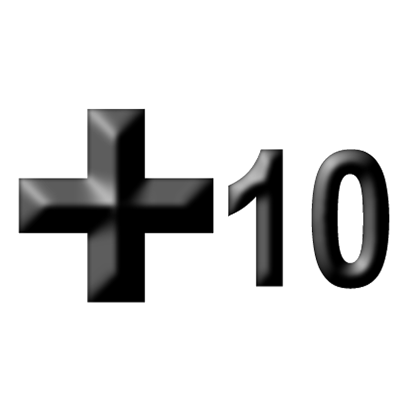
GreenGale or storm force winds are increasing. 10
Typhoon(颶風)
>118 (74+, Beaufort Force 12)
may exceed 220 (138)

Red
Green
RedHurricane force winds. Eye of typhoon may be passing directly over Hong Kong. See also
References
- ^ a b c d e f g h i j k l "Modernisation of The City" (in Chinese and English). Hong Kong Observatory. 2003. pp. 68. http://www.hko.gov.hk/publica/gen_pub/WeatheringTheStorm-4.pdf. Retrieved 2008-08-24.
- ^ http://www.hko.gov.hk/cgi-bin/hko/warndb_e1.pl?opt=1&sgnl=10&start_ym=194609&end_ym=201109&submit=Submit+Query
External links
Categories:- Tropical cyclone meteorology
- Geography of Hong Kong
- Science and technology in Hong Kong
- Disaster preparedness in Hong Kong
- Weather warnings and advisories


Wikimedia Foundation. 2010.