- Geography of Niger
-
 Satellite image of Niger
Niger is a landlocked nation in West Africa located along the border between the Sahara and Sub-Saharan regions. Its geographic coordinates are a longitude of 16°N and a latitude off 8°E. Its area is 1.267 million square kilometers, of which 1 266 700 km² is land and 300 km² water. This makes Niger slightly less than twice the size of the U.S. state of Texas.
Contents
Political geography
 Map of Niger
 Niger's cities, main towns and other centres
Niger borders seven countries and has a total of 5 697 km of borders. The longest border is Nigeria to the south, at 1 497 km. This is followed by Chad to the east (1 175 km), Algeria to the northnorthwest (956 km), and Mali at 821 km. Niger also has short borders in its far southwest frontier (Burkina Faso at 628 km and Benin at 266 km) and to the northnortheast (Libya at 354 km).
Physical geography
Climate
Niger's climate is mainly hot and dry, with much desert area. In the extreme south there is a tropical climate on the edges of the Niger River Basin. The terrain is predominantly desert plains and sand dunes, with flat to rolling plains in the south and hills in the north. Lake Chad is at the south-east corner of the country and is shared between Niger, Nigeria, Chad and Cameroon.
Extreme points
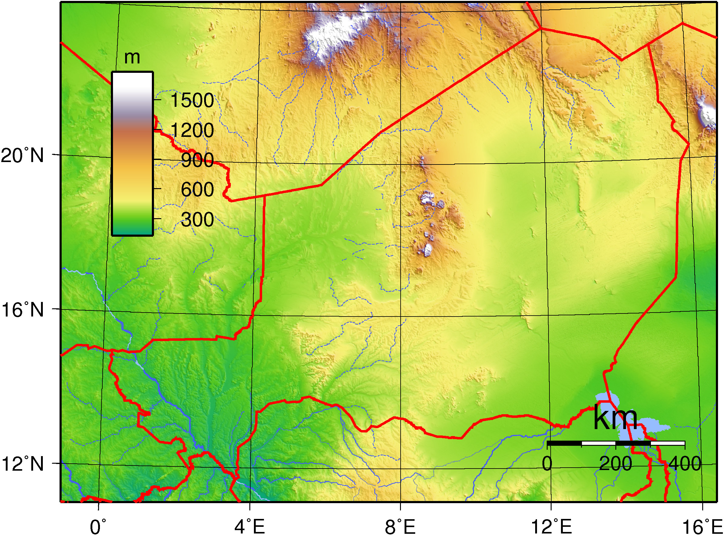
 Topography of Niger
- Northernmost Point: Tripoint with Algeria and Libya, Agadez Region: 23°31'N.[1]
- Southernmost Point: Benin/Niger/Nigeria tripoint, Dosso Region: 11°42'N
- Easternmost Point: border with Chad, Agadez Region: 16°00'E
- Westernmost Point: border with Mali and Burkina Faso, Tillaberi Region: 0°07'E
- Highest Point: Mont Idoukal-n-Taghès, Air Massif, Agadez Region:2,022 m (6,634 ft)[2]
- Lowest Point: Niger River at Nigeria border, Dosso Region: 200 m (656 ft)[2]
Natural resources
Main article: Mining in NigerNiger possesses the following natural resources:
Agricultural geography
Main article: Agriculture in NigerLand in Niger is used as arable land (660 km² of land in Niger is irrigated), and as pasture. There are some forests and woodland. The table below describes the land us in Niger, as of 1993.
Land use Use Percentage of Area arable land 3 permanent pastures 7 forests and woodland 2 other 88 Environment
Natural hazards
Main article: Sahel droughtRecurring droughts are a hazard in Niger.
Current issues
Current environmental issues in Niger include: overgrazing, soil erosion, deforestation, desertification and endangered wildlife populations (such as elephant, hippopotamus, giraffe, and lion), which are threatened because of poaching and habitat destruction.
International agreements
Niger is a party to the following agreements:
- Biodiversity
- Climate Change
- Desertification
- Endangered Species
- Environmental Modification
- Hazardous Wastes
- Nuclear Test Ban
- Ozone Layer Protection
- Wetlands
Niger has signed, but not ratified the Kyoto Protocol and Law of the Sea.
See also
- List of extreme points of Niger
References
- L. Herrmann, K. Stahr and K. Vennemann. Atlas of Natural and Agronomic Resources of Niger and Benin, "Deutsche Forschungsgemeinschaft" (German Research Foundation), the University of Hohenheim. (No date). Accessed 2008-02-22.
 Niger topics
 History Songhai Empire · Bornu Empire · Sultanate of Agadez · Sultanate of Damagaram · Dosso Kingdom · French West Africa · Tuareg RebellionPolitics Geography Economy and infrastructure Culture and society Demographics · Education · Films · Health · Holidays · Languages · Media · Music · Notable Nigeriens · Religion · FootballList of Niger-related topics Sovereign
states- Algeria
- Angola
- Benin
- Botswana
- Burkina Faso
- Burundi
- Cameroon
- Cape Verde
- Central African Republic
- Chad
- Comoros
- Democratic Republic of the Congo
- Republic of the Congo
- Côte d'Ivoire (Ivory Coast)
- Djibouti
- Egypt
- Equatorial Guinea
- Eritrea
- Ethiopia
- Gabon
- The Gambia
- Ghana
- Guinea
- Guinea-Bissau
- Kenya
- Lesotho
- Liberia
- Libya
- Madagascar
- Malawi
- Mali
- Mauritania
- Mauritius
- Morocco
- Mozambique
- Namibia
- Niger
- Nigeria
- Rwanda
- São Tomé and Príncipe
- Senegal
- Seychelles
- Sierra Leone
- Somalia
- South Africa
- South Sudan
- Sudan
- Swaziland
- Tanzania
- Togo
- Tunisia
- Uganda
- Zambia
- Zimbabwe
States with limited
recognition- Sahrawi Arab Democratic Republic
- Somaliland
Dependencies and
other territories- Canary Islands / Ceuta / Melilla / Plazas de soberanía (Spain)
- Madeira (Portugal)
- Mayotte / Réunion (France)
- Saint Helena / Ascension Island / Tristan da Cunha (United Kingdom)
- Western Sahara
Climate of Africa Sovereign
states- Algeria
- Angola
- Benin
- Botswana
- Burkina Faso
- Burundi
- Cameroon
- Cape Verde
- Central African Republic
- Chad
- Comoros
- Democratic Republic of the Congo
- Republic of the Congo
- Côte d'Ivoire (Ivory Coast)
- Djibouti
- Egypt
- Equatorial Guinea
- Eritrea
- Ethiopia
- Gabon
- The Gambia
- Ghana
- Guinea
- Guinea-Bissau
- Kenya
- Lesotho
- Liberia
- Libya
- Madagascar
- Malawi
- Mali
- Mauritania
- Mauritius
- Morocco
- Mozambique
- Namibia
- Niger
- Nigeria
- Rwanda
- São Tomé and Príncipe
- Senegal
- Seychelles
- Sierra Leone
- Somalia
- South Africa
- South Sudan
- Sudan
- Swaziland
- Tanzania
- Togo
- Tunisia
- Uganda
- Zambia
- Zimbabwe
States with limited
recognition- Sahrawi Arab Democratic Republic
- Somaliland
Dependencies and
other territories- Canary Islands / Ceuta / Melilla / Plazas de soberanía (Spain)
- Madeira (Portugal)
- Mayotte / Réunion (France)
- Saint Helena / Ascension Island / Tristan da Cunha (United Kingdom)
- Western Sahara
Categories:


Wikimedia Foundation. 2010.