- Mawson Station
-
This article is about the Mawson Antarctic base. For other uses, see Mawson (disambiguation).
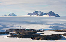 Mawson Station looking toward the David Range
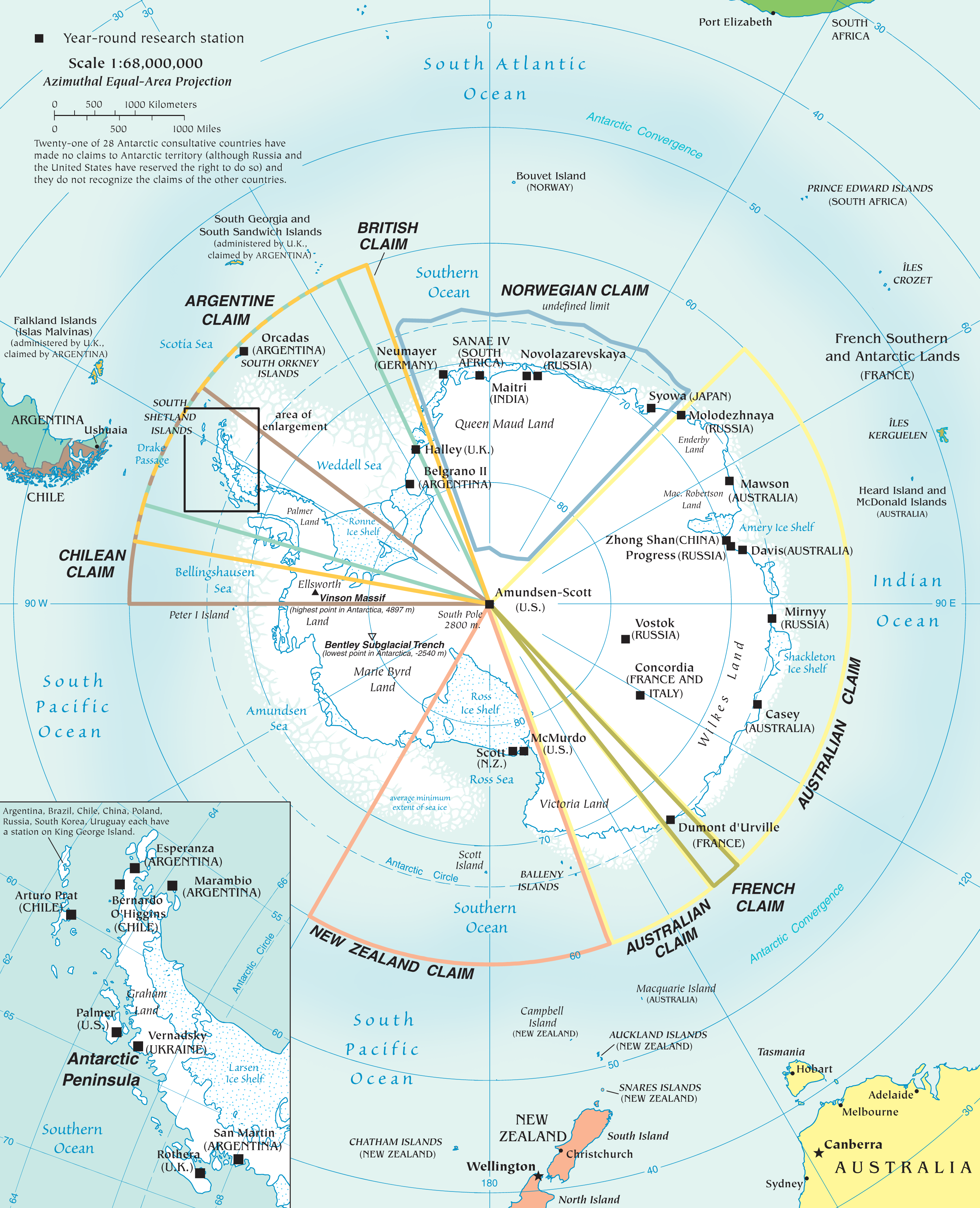
 Research stations and territorial claims in Antarctica (2002)
Mawson Station is one of three permanent Australian bases in the Australian Antarctic Territory of East Antarctica. Named after Antarctic explorer Sir Douglas Mawson, the base is managed by the Australian Antarctic Division (AAD). Established in 1954, Mawson is Australia's oldest Antarctic station and the oldest continuously inhabited Antarctic station south of the Antarctic Circle.
Contents
Purpose
Mawson Station is a base for scientific research programs including an underground cosmic ray detector, various long-term meteorological, aeronomy and geomagnetic studies, as well as ongoing conservation biology studies, in particular of nearby Auster rookery, a breeding ground for Emperor Penguins and Adélie Penguins.
Mawson Station houses approximately 20 personnel over winter and up to 60 in summer. It is the only Antarctic station to use wind generators for over 70% of its power needs, saving over 600,000 litres of diesel fuel per year. It is accessible by sea for only a short period each austral summer, between February and March.
History
In 1946, the Minister for External Affairs, H.V. Evatt indicated his support for a proposal by Douglas Mawson for the establishment of a permanent Australian base in Antarctica.[1] It was another seven years before a suitable ship, the Kista Dan could be chartered to set up facilities on the southern continent.
The station site was chosen in 1953 by Dr. Phillip Law, first director of the AAD, who drew on aerial photographs taken during the U.S. Operation Highjump (OpHjp) of 1946-1947 to select the site for its large natural harbour (Horseshoe Harbour) and permanently exposed rock for building.[1] The station was built during 1954. Some of the small pre-fabricated huts used in the first years remain on the station, but these are overshadowed by large steel-framed modular buildings dating from a major rebuilding program which started in the late 1970s.
Geography
Mawson Station is located at Holme Bay in Mac Robertson Land, East Antarctica, named in January 1930 by Sir Douglas Mawson during the first British Australian and New Zealand Antarctic Research Expedition (BANZARE) voyage, aboard Discovery. It is in a region which Mawson proclaimed as British territory on several occasions in 1930 and 1931 (including at Proclamation Island, Scullin Monolith and Cape Bruce), and later became Australian Antarctic Territory.
Some notable geographic features in the region include the Framnes Mountains, which form the dramatic backdrop to Mawson Station. The Framnes Mountains were named in the 1930s by Norwegian explorers financed by the shipowner and whaling magnate Lars Christensen.
Further away, to the northwest, lie the Napier Mountains, which were first visited by an ANARE survey party from Mawson Station in 1960. The survey party was led by Syd Kirkby, and included Terence James Elkins. The highest peak of this small range is Mount Elkins, which was named after Terence James Elkins, ionospheric physicist with ANARE at Mawson Station in 1960.
Climate
Mawson Station experiences a Polar climate:
Climate data for Mawson Station Month Jan Feb Mar Apr May Jun Jul Aug Sep Oct Nov Dec Year Average high °C (°F) 2.6
(36.7)−1.3
(29.7)−7.2
(19.0)−11.8
(10.8)−13.6
(7.5)−13.6
(7.5)−15
(5)−15.6
(3.9)−14.4
(6.1)−10
(14)−2.7
(27.1)2.1
(35.8)−8.4 Average low °C (°F) −2.6
(27.3)−7.3
(18.9)−13.2
(8.2)−17.3
(0.9)−19.3
(−2.7)−19.5
(−3.1)−20.8
(−5.4)−21.7
(−7.1)−20.6
(−5.1)−16.4
(2.5)−8.2
(17.2)−3.2
(26.2)−14.3 [citation needed] See also
References
- ^ a b Scott, Keith (1993). The Australian Geographic book of Antarctica. Terrey Hills, New South Wales: Australian Geographic. pp. 29—31. ISBN 1862760101.
External links
- Official website Australian Antarctic Division
- Australian Antarctic Division's Mawson Station page
- Mawson Station webcam
- Restoration of Biscoe Hut, one of the original 1954 buildings
- COMNAP Antarctic Facilities
- COMNAP Antarctic Facilities Map
Research stations of Antarctica Year-round Argentina- Belgrano II
- Esperanza
- Jubany
- Marambio
- Orcadas
- San Martín
- Casey
- Davis
- Mawson
- Macquarie Island
Europe- Princess Elisabeth (Belgium)
- Concordia / Dumont d'Urville (France)
- Concordia / Mario Zucchelli (Italy)
- Neumayer III (Germany)
- Troll (Norway)
- Arctowski (Poland)
- Halley / Rothera (UK)
- Vernadsky (Ukraine)
RussiaOthers- Comandante Ferraz (Brazil)
- Great Wall / Zhongshan (PR China)
- Maitri (India)
- Dome Fuji / Showa (Japan)
- King Sejong (South Korea)
- Scott (New Zealand)
- SANAE IV (South Africa)
- Artigas (Uruguay)
Summer - Almirante Brown / Cámara / Decepción / Matienzo / Petrel (Argentina)
- St. Kliment Ohridski (Bulgaria)
- Carvajal / González Videla / Risopatrón (Chile)
- Kunlun (China)
- Mendel (Czech Republic)
- Maldonado (Ecuador)
- Aboa (Finland)
- Kohnen (Germany)
- Zucchelli (Italy)
- Dome Fuji (Japan)
- Tor (Norway)
- Jinnah (Pakistan)
- Machu Picchu (Peru)
- Law-Racoviţă (Romania)
- Gabriel de Castilla / Juan Carlos I (Spain)
- Svea / Wasa (Sweden)
- Signy (UK)
- Byrd (United States)
- Elichiribehety (Uruguay)
Closed - Dakshin Gangotri (India)
- Asuka / Mizuho (Japan)
- Hallett / Vanda (New Zealand)
- Komsomolskaya / Leningradskaya / Molodyozhnaya / Russkaya (Soviet Union)
- Ellsworth (USA / Argentina)
- World Park Base (Greenpeace)
Categories:- Outposts of Antarctica
- Australian Antarctic Territory
- East Antarctica
- Science and technology in Australia

Wikimedia Foundation. 2010.