- Mexicali (municipality)
Infobox Settlement
name = Mexicali
settlement_type =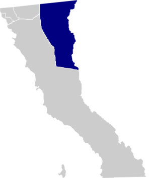
map_caption = Location of Mexicali in Baja California.
mapsize=150px
motto="Tierra Cálida"
( _en. Warm Land)
population_as_of=2005
population_total=855962
population_note=Data source: [http://www.inegi.gob.mx/est/contenidos/espanol/sistemas/conteo2005/localidad/iter/ INEGI]
population_density_km2=auto
area_total_km2=13700
leader_title = Municipal president
leader_name =Rodolfo Váldez
leader_party =PAN
subdivision_type2 = Municipal seat
subdivision_name2 =Mexicali
subdivision_type3 = Largest city
subdivision_name3 =Mexicali
blank_name =INEGI code
blank_info = 002
timezone = PST
utc_offset = -8
timezone_DST = PDT
utc_offset_DST = -7
established_title=Municipality established
established_date=December 29 ,1953 [es icon pp. 78–79, [http://redalyc.uaemex.mx/redalyc/pdf/530/53010102.pdf La Transformación de Baja California en Estado, 1931–1952] , Lawrence Douglas Taylor Hansen, "Estudios Fronterizos", 1, #1 (Jan-June 2000), UABC, Mexicali, pp. 47–87.]
website=es icon [http://www.mexicali.gob.mx/ Ayuntamiento de Mexicali]
footnotes=Source: [http://www.e-local.gob.mx/work/templates/enciclo/bajacalifornia/municipios/02002a.htm Enciclopedia de los Municipios de México]Mexicali is a municipality ( _es. municipio) in the Mexican state of
Baja California . Its municipal seat ( _es. cabecera municipal) is located in the city ofMexicali . According to the2000 census, it had a population of 764,602 inhabitants, and according to the 2005 census, it had 855,962 inhabitants. The municipality has an area of 13,700 km² (5,300 sq mi.) This includes many smaller outlying communities as well as the city of Mexicali. Also, the islands of Baja California located in theGulf of California are part of the municipality. Mexicali is the northernmost municipality ofLatin America .The city of Mexicali was founded in 1903, and its name is a
portmanteau of "Mexico" and "California", as is the name of Calexico,California across the border. This is an unusual pair of border cities in that Mexicali, on the Mexican side, is far larger than Calexico, on the U.S. side.Boroughs
Apart from the municipal seat of
Mexicali , the municipality of Mexicali is administratively subdivided into 14 boroughs ( _es. delegaciones):
#Los Algodones, located in the "Valley Zone".
#Bátaquez, located in the "Valley Zone".
#Cerro Prieto, located in the "Urban Zone", is part of the Mexicali metropolitan area.
#Venustiano Carranza, located in the "Valley Zone".
#Ciudad Morelos, informally known as Cuervos, located in the "Valley Zone".
#Colonias Nuevas, informally known as km 57, located in the "Valley Zone".
#Progreso, located in the "Urban Zone", is part of the Mexicali metropolitan area.
#Ejido Hermosillo, located in the "Valley Zone".
#Estación Delta, located in the "Valley Zone".
#Guadalupe Victoria, informally known as km 43, located in the "Valley Zone".
#González Ortega, informally known as Palaco, located in the "Urban Zone", is part of the Mexicali metropolitan area.
#Hechicera, located in the "Valley Zone".
#San Felipe, located in the "Coastal Zone", to the south on theGulf of California .
#Benito Juárez, informally known as Tecolotes, located in the "Valley Zone".The former borough ("delegación") of Compuertas is located in the eastern part of the city of Mexicali.
Major towns
*
Mexicali
* San Felipe
* Guadalupe Victoria
* Ciudad Morelos
* Los Algodonesee also
*
Municipalities of Baja California
*Baja California References
*es icon [http://www.inegi.gob.mx/est/contenidos/espanol/sistemas/conteo2005/localidad/iter/ Link to tables of population data from the 2005 Census] , INEGI: Instituto Nacional de Estadística, Geografía e Informática.
*es icon [http://www.e-local.gob.mx/work/templates/enciclo/bajacalifornia/municipios/02002a.htm Mexicali] , " [http://www.e-local.gob.mx/wb2/ELOCAL/ELOC_Enciclopedia Enciclopedia de los Municipios de México] ", Instituto Nacional Para el Federalismo y el Desarrollo Municipal, SEGOB. Accessed on lineNovember 15 ,2007 .
*es icon [http://www.mexicali.gob.mx/ImagenesCS/CONAMM/ubicacion.html Ubicación Geográfica] , Mexicali government web site. Describes subdivisions of Mexicali.External links
*es icon [http://www.mexicali.gob.mx/ Ayuntamiento de Mexicali] , official government web site.
*en icon/es icon [http://www.mexicaliturismo.com/ Mexicali Tourism Guide]

Wikimedia Foundation. 2010.