- Moreton Bay
-
For the local government area, see Moreton Bay Region.
Moreton Bay 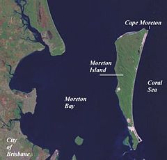
Some features in north of the bay Location South East Queensland River sources Logan River, Brisbane River, Albert River, Pine River, Pimpama River, Caboolture River Ocean/sea sources Coral Sea Countries Australia Max. length 125 km Max. width 35 km Surface area 1,523 km² Average depth 6.8 m Islands Moreton Island, North Stradbroke Island, Bribie Island Settlements Brisbane  Location of Moreton Bay
Moreton Bay is a bay on the eastern coast of Australia 45 km from Brisbane, Queensland. It is one of Queensland's most important coastal resources.[1] The waters of Moreton Bay are a popular destination for recreational anglers and are used by commercial operators who provide seafood to market.
The Port of Brisbane coordinates large traffic along the shipping channel which crosses the northern section of the bay. The bay serves as a safe approach to the airport and reduces noise pollution over the city to the west of the runway. A number of barge, ferry and water-taxi services also travel over the bay.
Moreton Bay was the site of conflict between indigenous Australians and early European settlers. It contains environmentally significant habitats and large areas of sandbanks. The bay is the only place in Australia where dugong gather into herds. Many parts of the mainland foreshore and southern islands are settled.
Moreton Bay is described as lagoonal because of the existence of a series of off-shore barrier islands that restrict the flow of oceanic water.[2] The tidal range is moderate at 1.5–2 m in range. Moreton Bay has an average depth of 6.8 m.[2] This shallow depth lets light filter through to the seafloor, allowing an array of marine plants to grow which support a diverse range of fauna. The bay itself covers 1,523 km² and has a catchment area 14 times larger, covering 21,220 km².[2] The waters of the bay are mostly blue in colour. Western parts of the bay are sometimes tinted green from algae, brown from suspended sediments or yellow-brown from humic runoff.[2]
Contents
History
Moreton Bay was formed roughly 6000 years ago as the sea level rose and inundated what was then the floodplains of the Brisbane River.
Moreton Bay (Aboriginal name - Quandamooka) and its islands were inhabited by Aboriginal tribes. The name Morton's Bay was given by Captain Cook when he passed the area on 15 May 1770, honouring Lord Morton, president of the Royal Society.[3] The spelling Moreton was an error in the first published account of Cook's voyage[4] (Hawkesworth's Voyages[5]). Cook gave the name only to the bight formed by the northern end of Stradbroke Island (in 1770, there was only one island) and the eastern side of Moreton Island. He was unaware of the South Passage (as it's now called) between the two islands, and did not sail into what is the present Moreton Bay.

Matthew Flinders was the first recorded European to enter the Bay in 1799 touching down at the Pumicestone Passage, Redcliffe and Coochiemudlo Island. He was followed by John Oxley who explored the Brisbane River in 1823. On a subsequent visit in the following year, Oxley established the first European settlement in the Bay at the present site of Redcliffe.[citation needed]
After Oxley in 1823 came convicts and soldiers. As the South Passage between Moreton and Stradbroke Islands was the shortest shipping route, a depot and pilot station were established at Amity Point in 1825.[6]
European settlement began in earnest after the abandonment of the Redcliffe settlement, and work began on the new convict settlement several miles up the Brisbane River in 1825. Within a couple years this new settlement was growing rapidly and the number of ships entering the bay was increasing. As a result, the facilities required to service the pilot station at Amity grew, and in 1827 convicts were sent to the island to build a new causeway at Dunwich, remnants of which can still be found on the same site. Within a year the first permanent European settlement at Dunwich had been built.[6] Due to poor weather, smuggling, and conflict with aborigines this convict out-station was difficult to sustain and was closed in 1831.[7]
 The foreshore at Manly, 2004.
The first immigrant ship from England, the Artemisia, reached Moreton Bay in December 1848 after a four month journey.[8] The next year saw the arrival of the Fortitude carrying more free immigrants to the settlement.
By the 1850s the regions earliest industry was utilising the bay for the transport of timber. After felling the logs were dragged or rolled into flooded streams from where they were washed downstream to tidal reaches and bound together into rafts. After the floods had ceased and tides returned to normal, the currents of the bay and sometimes boats were used to direct the timber north to the Brisbane River or to Dunwich for shipment to Sydney.[9]
The bay was home to the Lightship Rose which provided a permanent navigation aid to passing ships at the mouth of the Brisbane River. The John Oxley was another notable boat which temporarily acted as a pilot ship.
Car ferries began crossing the bay to reach North Stradbroke Island in 1947, leading to an increase in tourism on the island.[6] In the 1950s both sand mining and the first land sales at Point Lookout occurred.[6]
European contact with Aborigines
At first the Quandamooka tribes had a choice of avoiding contact or engaging with the Europeans at the various small government institutions that were established on the mainland and on Minjerribah (Stradbroke Island). Aboriginal labour and resources were however, voluntarily supplied to assist these newcomers, for example, at the pilot station. Problems came about when the newcomers displayed a lack of respect for Aboriginal marriage rules, stole bones and other artefacts and desecrated sites important to the Aboriginals.[10] This produced a period of conflict through the 1830s, sometimes followed up by reprisals with guns, during which a number of Aboriginal people were massacred.
Like the mainland tribes, the Nooghie, Noonuccal and Goenpul people struggled when Moreton Bay was opened up to free settlers. The mainland Aboriginal people in particular were progressively deprived of the traditional hunting grounds and food. When they turned to killing domestic stock in order to survive, they were rounded up and shot. As their tribal groups and way of life disintegrated, many drifted towards towns and cities. Because of their isolation, the people of the islands however, managed to keep a lot of their traditional ways alive.[citation needed]
In 1843, Catholic Missionaries chose Dunwich as the site for the first Catholic Mission to Australian Aborigines.[7] The sand islands of Quandamooka did not support pasturage suitable for sheep and cattle, and thus there did not occur conversion of large tracts of land into farms and pastoral properties and the subsequent widespread annihilation and displacement of Aboriginal people. The very existence of the quarantine station on Stradbroke Island from 1850 to the 1870s led to the official discouragement of pastoralism or wider settlement for fear of spreading disease.[6] Another reason for discouraging settlement was to reduce the likelihood of incoming vessels to the bay evading customs duty.
 The first of the Tangalooma Wrecks were placed in 1963, one year after the whaling station ceased operations.
Thus the European usage and occupation of Quandamooka in the 19th century was largely restricted to government institutions on small portions on the islands, and with free enterprise business men like the Campbell brothers who ran a saltworks and sugar plantations on Russell and Macleay islands, and the early fishing and oystering businesses in the bay who employed the Aboriginal people of Quandamooka.
Aboriginal peoples were a source of labour for various institutions and enterprises from the time of the first pilot station. Conflict with Europeans intensified during the middle part of the 19th century, leading to significant numbers of Aboriginal people being killed (including at the hands of the native police). Despite these conflicts other Aboriginal people were able to evade intense contact due to the lack of European activity on the bay islands. From the 1830s to 1865 there remained virtual exclusive Aboriginal possession of most of Quandamooka. However trade and social interaction with the mainland groups gradually diminished due to the outward march of pastoral settlement on the mainland. This resulted in unrepairable damage to indigenous social networks and patterns of group intermarriage, as well as joint ceremonial activities.
 The harbour at Cleveland, 2006
Recent
On 1 September 2007 four people were killed in a boat accident on the bay, two kilometres from the Pinkenba boat ramp. Ten others were injured.[11]
The bay's marine park zoning plan was renewed in 2008. Despite angst from both commercial and recreational fishers, draft Queensland Government plans indicate further fishing restrictions aiming to protect more than 15 % of important marine and coastal environments.[12] Artificial reefs could be placed in Moreton Bay to ease the concerns of fishermen who fear they are being forced out. The State Government will spend $1 million on research, planning and construction of a new concrete reef in the bay.[13]
An oil spill occurred in March 2009 from the MV Pacific Adventurer dumping 100 tonnes of oil, 30 tonnes of fuel and other toxic chemicals on Brisbane's suburban beaches. Premier Anna Bligh described the spill as "worst environmental disaster Queensland has ever seen".[14]
Fresh concerns over the health of the bay and its water quality were raised in October 2009 after whales and a large number of the endangered Loggerhead Sea Turtle were found to be dying in the bay.[15] In the same month a report was released indicating the overall quality of the bay's water had declined significantly, despite hundreds of millions of dollars spent on better sewage treatment and implementing run-off controls.[16] Ten out of eighteen estuaries that were monitored had a decline in quality. Blame was placed on heavy rains that washed sediment and nutrients into the bay after a drought.[16]
After the 2011 Brisbane River floods washed contaminated water into the bay commercial fishermen and recreation anglers were warned not catch or eat seafood from its waters.[17] The flood plume was investigated to monitor its impact on the bay's marine ecosystems. It contained sewerage, pesticides, heavy metals such as lead and zinc as well as hydrocarbons.[17][18]
Through the use of underwater cameras and sensors, the Royal Australian Navy minehunter HMAS Huon was used to locate sunken debris , particularly in shipping channels.[17] The CSIRO used a robotic underwater glider to make sub-surface measurements.[19] Together with satellite images and other data researchers will assess the effects of an extreme flood event on the waters of Moreton Bay. Sediment surveys revealed that most of the bay had cleared and that fishing could resume by 9 February.[20]
Geography
 The islands of southern Moreton Bay
The bay extends some 125 km from Caloundra in the north almost to Surfers Paradise in the south.[21] The bay's southern navigation entrance is the Gold Coast Seaway. The bay is 35 km across at its widest point.
It is separated from the Pacific Ocean by a chain of three sand islands - Moreton Island in the north, North Stradbroke Island, and South Stradbroke Island in the south. Tipplers Passage is the main channel on the western coast of South Stradbroke Island. The Gold Coast Seaway is at the southern extent of Moreton Bay, before the Gold Coast Broadwater.
The bay itself contains around 360 islands in total. This includes the populated Russell, Macleay, Lamb and Karragarra Islands collectively known as the Southern Moreton Bay Islands. Residential development has also occurred on Coochiemudlo Island and Bribie Island. In the past Peel Island has been used as a sisal plantation, quarantine station, asylum and a leper colony.
Moreton Bay is generally shallow and sandy, though a substantive channel is maintained to allow access to the Port of Brisbane at Fisherman Islands at the mouth of the Brisbane River, for international shipping. As well as the Brisbane River, the Pimpama River, Logan River, Albert River, Pine River, Tingalpa Creek and the Schulz Canal all empty into Moreton Bay. Within Moreton Bay are the smaller bays of Waterloo Bay, Redland Bay, Raby Bay, Deception Bay and Bramble Bay.
 Foreshores of the bay at Scarborough, 2007.
The bay contains a number of island villages such as the settlement on the bayside of Moreton Island, Tangalooma and on North Stradbroke, Dunwich and Amity Point. Prominent coastal communities and mainland suburbs situated on the bay include Deception Bay, Scarborough, Redcliffe, Margate, Woody Point, Brighton, Sandgate, Cleveland, Raby Bay and Victoria Point and Redland Bay. Other attractions in the bay include Pumicestone Passage and numerous boat ramps, marinas and jetties, including the Shorncliffe pier.
Protected areas
Moreton Island is protected as Moreton Island National Park. The bay itself contains St Helena Island National Park and the Moreton Bay Marine Park with areas designated under the Marine Park Zoning Plan. The Marine Park was declared in 1993 and covers 3400 square kilometres.[22] Parts of the bay are also protected under the Southern Moreton Bay Islands National Park. According to the Ramsar Wetland Convention 1971, parts of Moreton Bay are listed as a wetland of international importance.
To make up for the fishing areas lost to the 2009 expansion of the Moreton Bay Marine Park, the Queensland Government agreed to create a total of six artificial reefs for anglers. The reefs are constructed from specially designed balls of concrete which will provide habitat for fish species.[23] According to former Sustainability Minister Andrew McNamara the bay produces a commercial catch valued at A$25 million and that $4 million worth of this figure has become off-limits with the rezoning.[24]
Sandbanks
Moreton Bay is filled with sandbanks. Between Tangalooma and Skirmish Point on Bribie Island are the Middle Banks, Central Banks and Western Banks. From north of Moreton Island towards Caloundra are the Yulle Road, Spitfire Bank, and the Salamander Bank, amongst others.
Amity Banks are found just west of Amity Point, while the Moreton Banks lie to the west of the southern tip of Moreton Island. These banks can be hazard for marine navigation because they are constantly changing due to tidal currents.
 Sandbanks in Moreton Bay
The Middle Banks area close to Moreton Island has been used in the past as a source of sand for large projects such as the nearby Brisbane Airport and port facilities. Past dredging has removed 18 Mn3 and the removal of another 40 Mn3 is planned.[25] Future sand extraction is expected to aid a major shipping channel straightening project.
To ensure the shipping channel remains open, several areas of the bay have been allocated for dredged material dumping sites. These sites have been selected to provide beach nourishment, aiding the natural long shore transport of sand along ocean beaches.
Events
In 1949, the first annual Brisbane to Gladstone yacht race was held starting in Moreton Bay. This event is a popular sailing event held on the bay and is one of many that occur. There are several other sailing events held throughout the bay, generally starting from the Manly Royal Queensland Yacht Squadron. Recreational fishing is a big part of the bay's history and there is an annual Moreton Bay Classic fishing competition run by Brisbane Fishing Online held from the Manly foreshore. The bay is home to many watersports and activities including jet-skiing, windsurfing and water-skiing. Snorkelling is especially popular around Tangalooma on Moreton Island as well.
Flora and fauna
The bay's heritage protected wetlands, mudflats, and waterways are some of the healthiest in the region, supporting seasonally up to 25 % of Australia's bird species.[26] Collectively, around 50,000 wading birds visit the Moreton Bay each year,[21] and its wetlands are classified by BirdLife International as an Important Bird Area (IBA).[27] The bay is also home to other abundant wildlife, including whales, dolphins, dugong, sharks and turtles.
The Loggerhead turtle population in the bay is the most significant in the country.[28] Dugongs and turtles, which are attracted to the seagrass meadows for food, are threatened due to being prone to boat strike impacts.[21][29] Moreton Bay is the only place in Australia where dugongs gather in herds.[30] In the past the dugongs in herds numbered in the thousands. Some herds 5 km long by 250 m wide, were seen during the 1800s.[30] In 2009, there was just between 600 and 800 remaining.[28]
The bay is popular with recreational anglers. The Moreton Bay bug (Thenus orientalis) is a species of slipper lobster found throughout the waters of Australia's north coast. The Bug is a relatively expensive delicacy served in many restaurants in Queensland. The Moreton Bay Fig (Ficus macrophylla) is endemic to the east coast of Australia within a range centred on Moreton Bay.
The southern and western parts of the bay contain shallow mud-layered waters that are protected from strong wave action by the barrier islands. This has provided excellent habitat for mangroves of which seven different species thrive within the bay.[31] About 1% of the bay is coral reef.[32] Land clearing and settlement in the catchment has led to unfavourable conditions for coral growth. Climate change is expected to raise sea levels and produce warmer waters that will aid coral growth in the bay.[32] The bay may experience widespread outbreaks of bacteria lyngbya which can cause skin lesions and asthma attacks upon contact.[33]
See also
References
- ^ South East Queensland Regional Strategic Group (2000). Strategic Guide to Natural Resource Management in South East Queensland. pp. 56. ISBN 0734517408.
- ^ a b c d Dennison, William C.; Eva G. Abal (1999). Moreton Bay Study: A Scientific Basis for the Healthy Waterways Campaign. Brisbane: South East Queensland Regional Water Quality Management Strategy Team. pp. 23–25. ISBN 0958646818.
- ^ Environmental Protection Agency (Queensland) (2000). Heritage Trails of the Great South East. State of Queensland. pp. 4. ISBN 0-7345-1008-X.
- ^ Ray Parkin, H. M. Bark Endeavour, Miegunyah Press, second edition 2003, ISBN 0-522-85093-6, page 226.
- ^ Voyages in the Southern Hemisphere, John Hawkesworth, 1773, volumes II-III, page 513 (online at the National Library of Australia).
- ^ a b c d e "Redland City Council: North Stradbroke Island". Redland City Council. http://www.redland.qld.gov.au/AboutRedlands/NorthStradbrokeIsland/Pages/default.aspx. Retrieved 4 November 2010.
- ^ a b "Dunwich Cemetery (entry CHIMS15548)". Queensland Heritage Register. Queensland Environmental Protection Agency. http://www.epa.qld.gov.au/chims/placeDetail.html?siteId=15548. Retrieved 2009-08-29.
- ^ Hogan, Janet (1982). Living History of Brisbane. Spring Hill, Queensland: Boolarong Publications. pp. 24–25. ISBN 0908175418.
- ^ Roberts, Beryl (1991). Stories of the Southside. Archerfield, Queensland: Aussie Books. pp. 75. ISBN 094733601X.
- ^ Evans, Raymond (2007). A History of Queensland. Port Melbourne, Victoria: Cambridge University Press. pp. 46. ISBN 9780521876926.
- ^ "Four dead, 10 injured after boat collision". ABC News Online, 1 September, 2007
- ^ Fishers furious at Moreton Bay bans. Patrick Lion. The Courier Mail, 2 December, 2007. The new Moreton Bay Marine Park was launched on the 1st of March, 2009. Retrieved 10 December 2007.
- ^ Giles, Darren (2008-02-10). "Artificial reefs plan to aid Bay". The Sunday Mail. http://www.news.com.au/couriermail/story/0,23739,23186696-5007190,00.html
- ^ Pacific Adventurer oil spill a disaster says Anna Bligh
- ^ Greg Stolz (19 October 2009). "Mud Island becomes dumping ground for dead whales". Courier Mail. Queensland Newspapers. http://www.news.com.au/couriermail/story/0,1,26227602-3102,00.html. Retrieved 2009-10-26.
- ^ a b Brian Williams (22 October 2009). "Moreton Bay water quality results take plunge". Courier Mail. Queensland Newspapers. http://www.news.com.au/couriermail/story/0,20797,26242168-3102,00.html?from=public_rss. Retrieved 2009-10-26.
- ^ a b c "Flooded bay a no-go". Sunshine Coast Daily (APN News & Media). 24 January 2011. http://www.sunshinecoastdaily.com.au/story/2011/01/24/flooded-bay-a-no-go/. Retrieved 24 January 2011.
- ^ Phil Hammond & Andrew MacDonald (27 January 2011). "Toxic soup washed into Bay puts seafood and jobs at risk". Herald Sun (Herald and Weekly Times). http://www.heraldsun.com.au/news/breaking-news/toxic-soup-washed-into-bay-puts-seafood-and-jobs-at-risk/story-fn7ikbtj-1225995231202. Retrieved 28 February 2011.
- ^ "Robotic Glider To Map Moreton Bay Impacts". TerraDaily (SpaceDaily). 25 January 2011. http://www.terradaily.com/reports/Robotic_Glider_To_Map_Moreton_Bay_Impacts_999.html. Retrieved 28 February 2011.
- ^ "Fishing resumes in parts of Moreton Bay". Brisbane Times (Fairfax Media). 9 February 2011. http://www.brisbanetimes.com.au/queensland/fishing-resumes-in-parts-of-moreton-bay-20110209-1am60.html. Retrieved 28 February 2011.
- ^ a b c "Moreton Bay Marine Park". Moreton Bay Regional Council. http://www.moretonbay.qld.gov.au/guide.aspx?display=attractions&sort=type&show=Beaches-Foreshores. Retrieved 2009-08-29.
- ^ Moreton Bay Marine Park. Environmental Protection Agency. Retrieved 10 December 2007.
- ^ Chris O'Brien (4 OCtober 2010). "More artificial reefs planned for Moreton Bay". ABC News Online (Australian Broadcasting Corporation). http://www.abc.net.au/news/stories/2010/10/04/3028522.htm?site=news. Retrieved 4 November 2010.
- ^ Brian Williams and Rosemary Odgers (28 October 2008). "Moreton Bay rezoning to hit families, say fishermen". The Courier-Mail (Queensland Newspapers). http://www.couriermail.com.au/news/queensland/rezoning-to-hit-fish-supply/story-e6freoof-1111117804699. Retrieved 6 November 2010.
- ^ New Parallel Runway Draft EIS/MDP Middle Banks, Moreton Bay Chapter 1. p 4. Brisbane Airport Corporation
- ^ South East Queensland Regional Strategy Group. Strategic Guide to Resource Management in South East Queensland. November 2000. p 115.
- ^ "IBA: Moreton Bay & Pumicestone Passage". Birdata. Birds Australia. http://www.birdata.com.au/iba.vm. Retrieved 2011-06-06.
- ^ a b McBride, Frank; et al (2009). Brisbane 150 Stories. Brisbane City Council Publication. pp. 292–293. ISBN 978-1-875091-60-6.
- ^ Boat strike impact on turtle and dugong in Moreton Bay, Queensland Government, Environmental Protection Agency Marine Parks
- ^ a b Shilton, Peter (2005). Natural Areas of Queensland. Mount Gravatt, Queensland: Goldpress. p. 180. ISBN 0-9758275-0-2.
- ^ Horton, Helen (1983). Islands of Moreton Bay. Spring Hill, Queensland: Boolarong Publications. pp. 10. ISBN 0908175671.
- ^ a b "Scientists Test Moreton Bay As Coral 'Lifeboat'". SpaceDaily. 28 July 2010. http://www.terradaily.com/reports/Scientists_Test_Moreton_Bay_As_Coral_Lifeboat_999.html. Retrieved 28 July 2010.
- ^ "Locals urged to avoid bacteria blooms". ABC News Online (Australian Broadcasting Corporation). 28 November 2007. http://www.abc.net.au/news/stories/2007/11/28/2104288.htm?site=news. Retrieved 18 August 2010.
External links
- SEQ History South East Queensland History
- Moreton Bay Database - a detailed chronicle of events
- BayJournal An online news source publishing one story a day about the Bay.
- Australian Folk Songs: Moreton Bay Folk song about the penal colony at Moreton Bay
- Pencil drawing of Moreton Bay settlement, ca. 1835 by Henry Boucher Bowerman. Digitised and held by Heritage Collections, State Library of Queensland.
Categories:- Australian penal colonies
- Defunct prisons in Queensland
- Bays of Queensland
- Ramsar sites in Australia
- Important Bird Areas of Australia
- South East Queensland


Wikimedia Foundation. 2010.