- Charlestown State Park
-
Charlestown State Park, Indiana, USA IUCN Category V (Protected Landscape/Seascape)Map of the U.S. state of Indiana showing the location of Charlestown State Park
Location Clark County, Indiana, USA Nearest city Charlestown, Indiana Coordinates 38°25′48″N 85°37′48″W / 38.43°N 85.63°WCoordinates: 38°25′48″N 85°37′48″W / 38.43°N 85.63°W Area 5,100 acres (20.6 km2) Established October 12, 1996 Visitors 131,761 (in 2008-2009) Governing body Indiana Department of Natural Resources 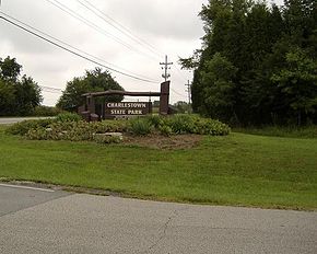 Entrance of Charlestown State Park
Charlestown State Park is an Indiana state park on 5,100 acres (20.64 km2) in Clark County, Indiana, in the United States. The park is on the banks of the Ohio River, 1 mile (2 km) east of Charlestown. It was once part of the Indiana Army Ammunition Plant (INAAP), and was donated in separate parcels to the Indiana state government. In 1993, the state of Indiana was given 859 acres (3.48 km2) , and in 1994 was given an additional 1,125 acres (4.55 km2) . When the park opened in 1996, it encompassed 2,400 acres (9.7 km2). With an additional 2,600 acres (10.5 km2) given by the INAAP in 2004, the park has 5,100 acres (20.6 km2), making it the third largest state park in Indiana.[1] The park attracts 131,000 people a year.[2]
Contents
Features
The main feature of the park is various scenic trails overlooking Fourteen Mile Creek, noted for being one of the oldest unglaciated stream valleys in the state. On the peninsula the creek forms where it meets the Ohio River stands an isolated bedrock ridge called the Devil's Backbone. According to legend, the Devil's Backbone forms part of the remains of an ancient stone fortress built by Welsh adventurers who traveled to the Ohio Valley in the 12th century, though the story is unsubstantiated. The park does not provide any access to this peninsula from its trails. At one time there was a footbridge across the creek used for accessing the Rose Island amusement park, but only concrete pilings remain on each side of the creek.
Devonian fossils and karst sinkholes can be found in the park, in addition to 72 species of birds, including bluebirds, black vultures and bald eagles.
The park is scheduled for $3 million in improvements, which were delayed in January 2006 when workers building a new boat ramp found a Native American cooking area dating back to 2,000 B.C. The remains of firepits and stone slabs that would be used to crack nuts were found, as well as Laurel chert, from which stone tools were made. only once the archaeological surveys were done could work on the improvements, including a five-lane boat ramp, and a riverfront walking trail, continue. In September, 2006 construction of the new boat ramps restarted.[3] The boat ramps opened in June 2007.
In September 2011, the historic Portersville Bridge was relocated and reconstructed to cross the creek and connect Rose Island for the first time.[4]
Future plans
There are still railroad tracks and private houses on the property, and the Indiana state government is still deciding what to do with them. Future developments confirmed by the state for the park include a swimming pool, access to Rose Island via a pedestrian bridge, more trails, improvements to the campground and cabins.[5]
Gallery
-

Park office
-

Distant view of river landing
-

River landing
-

Remains of the area's time as part of the IAAP still exist all over the property
-

Road leading to the river landing
-

Start of Trail 3, using remains of the road to Rose Island
-

Trail 3 leading from the Rose Island section, where the ruggedness start
-

Waterfront along Fourteen Mile Creek
References
- ^ John Fleshman. "Old ammo plant cleaned up for new use". United States Army Corps of Engineers. Archived from the original on 2007-08-23. http://web.archive.org/web/20070823213700/http://www.hq.usace.army.mil/cepa/pubs/nov05/story16.htm. Retrieved 2007-04-02.
- ^ The News and Tribune - SMALL-TOWN GROWING SPURT: Charlestown deals with growing population
- ^ David Mann. "Boat ramp construction begins near Charlestown". The Evening News and The Tribune. http://www.news-tribune.net/siteSearch/apstorysection/local_story_256164749.html. Retrieved 2007-04-02.
- ^ http://www.insideindianabusiness.com/newsitem.asp?ID=49956
- ^ State leaders sure Charlestown State Park will see improvements http://www.news-tribune.net/local/local_story_202011721.html
- "Charlestown State Park". Indiana Department of Natural Resources. http://www.in.gov/dnr/parklake/2986.htm. Retrieved 2007-04-02. (Official Site)
- "News Release - October 7, 1996: Charlestown State Park opens Oct. 12: New state park offers exciting vistas, 2,100 acres (8.5 km2) for recreation". Indiana Department of Natural Resources. http://www.state.in.us/dnr/news-rel/1996/oct7a96.htm. Retrieved 2007-04-02.
- "Statistics: Parks & Reservoirs Visitation". Indiana Department of Natural Resources. http://www.in.gov/dnr/parklake/about_stats.html. Retrieved 2007-04-02.
- "Charlestown State Park, review of the trails". BackcampPack.com. http://www.backpackcamp.com/Charlestown.html. Retrieved 2007-04-02.
- United States Geological Survey. "USGS Charlestown (IN,KY) Topo Map". TopoQuest. http://www.topoquest.com/map.asp?lat=38.43154&lon=-85.62726&datum=nad27&layer=DRG. Retrieved 2008-07-05.
List of Parks in Louisville Metro Area Kentucky Parks Beargrass Creek · Belvedere · Bernheim Forest · Blackacre · Central Park · Cherokee Park · Chickasaw Park · Extreme Park · Fort Nelson Park · Joe Creason · Iroquois Park · Jefferson Memorial Forest · Seneca Park · Shawnee Park · Tom Sawyer State Park · Waterfront ParkIndiana Parks Charlestown State Park · Clark State Forest · Falls of the Ohio State Park · Lapping Park · Perrin Park · Sam Peden Community Park · Warder ParkProtected Areas of Indiana National Park Service National Forests National Wildlife Refuges National Natural Landmarks State Parks Brown County • Chain O'Lakes • Charlestown • Clifty Falls • Falls of the Ohio • Fort Harrison • Harmonie • Indiana Dunes • Lincoln • McCormick's Creek • Mounds • O'Bannon Woods • Ouabache • Pokagon • Potato Creek • Prophetstown • Shades • Shakamak • Spring Mill • Summit Lake • Tippecanoe River • Turkey Run • Versailles • White River • Whitewater Memorial
State Forests and State Recreation Areas Clark • Deam Lake • Ferdinand • Greene-Sullivan • Harrison-Crawford • Jackson-Washington • Martin • Morgan-Monroe • Owen-Putnam • Pike • Salamonie River • Selmier • Starve-Hollow • Yellowwood
National Historic Landmarks National Register of Historic Places Indiana Department of Natural Resources Categories:- IUCN Category V
- Protected areas established in 1996
- Charlestown, Indiana
- Indiana state parks
- Protected areas of Clark County, Indiana
-


Wikimedia Foundation. 2010.