- New Amsterdam
-
This article is about the settlement that became New York City. For other uses, see New Amsterdam (disambiguation).
 Drawing of New Amsterdam from 1648, found in 1991 in Vienna's Albertina, is probably the oldest image found to date
New Netherland series Exploration Fortifications: • Fort Nassau (North)
• Fort Orange
• Fort Nassau (South)
• Fort Goede Hoop
• De Wal
• Fort Wilhelmus
• Fort Beversreede
• Fort Nya Korsholm
• De Rondout
Settlements: • New Amsterdam
• Rensselaerswyck
• Beverwijck
• Wiltwyck
• Bergen
• Pavonia
• Vriessendael
• Achter Col
• Heemstede
• Rustdorp
• Midwout
• Boswyck
• Swaanendael
The Patroon System Directors of New Netherland: Cornelius Jacobsen May (1620-25)
Willem Verhulst (1625-26)
Peter Minuit (1626-32)
Sebastiaen Jansen Krol (1632-33)
Wouter van Twiller (1633-38)
Willem Kieft (1638-47)
Peter Stuyvesant (1647-64)
People of New Netherland Flushing Remonstrance 
New Amsterdam (Dutch: Nieuw-Amsterdam) was a 17th-century Dutch colonial settlement that served as the capital of New Netherland. It later became New York City.
The settlement, outside of Fort Amsterdam on Manhattan Island in the New Netherland territory (1614–1664), was situated between 38 and 42 degrees latitude and was as a provincial extension of the Dutch Republic as of 1624. Situated on the strategic, fortifiable southern tip of the island of Manhattan, the fort was meant to defend the Dutch East India Company's fur trade operations in the North River (Hudson River). Fort Amsterdam was designated the capital of the province in 1625.
The 1625 date of the founding of New Amsterdam is now commemorated in the official Seal of New York City (formerly, the year on the seal was 1664, the year of the provisional Articles of Transfer, ensuring New Netherlanders that they "shall keep and enjoy the liberty of their consciences in religion", negotiated with the English by Petrus Stuyvesant and his council).
Contents
History
See also: Dutch colonization of the Americas and History of New York City A map of the Hudson River Valley c. 1635 (North is to the right)
Early Settlement (1609–1625)
Main article: New NetherlandThe first recorded exploration by the Dutch of the area around what is now called New York Bay was in 1609 with the voyage of the ship Halve Maen or "Half Moon", captained by Henry Hudson,[1] in the service of the Dutch Republic, as the emissary of Holland's stadholder Maurits. Hudson named the river the Mauritius River and was covertly attempting to find the Northwest Passage for the Dutch East India Company. Instead, he brought back news about the possibility of exploitation of beaver pelts in the area, leading to private commercial interest by the Dutch who sent commercial, private missions to the area the following years.
At the time, beaver pelts were highly prized in Europe, because the fur could be felted to make waterproof hats. A by-product of the trade in beaver pelts was castoreum—the secretion of the animals' anal glands—which was used for its supposed medicinal properties. The expeditions by Adriaen Block and Hendrick Christiansz in 1611, 1612, 1613 and 1614 resulted in the surveying and charting of the region from the 38th parallel to the 45th parallel. On their 1614 map, which gave them a four year trade monopoly under a patent of the States General, they named the newly discovered and mapped territory New Netherland for the first time. It also showed the first year-round trading presence in New Netherland, Fort Nassau, which would be replaced in 1624 by Fort Orange, which eventually grew into the town of Beverwyck, now Albany.
The territory of Novo Belgio[2] or New Netherland, comprising the Northeast's largest rivers with access to the beaver trade, was originally a private, profit-making commercial enterprise focusing on cementing alliances and conducting trade with the diverse Indian tribes. They enabled the surveying and exploration of the region as a prelude to an anticipated official settlement by the Dutch Republic, which occurred in 1624.
Pilgrims attempt to settle in the Hudson River area
In 1620 the Pilgrims attempted to sail to the Hudson River from England. However, the Mayflower reached Cape Cod (now part of Massachusetts) on November 9, 1620, after a voyage of 64 days.[3] For a variety of reasons, primarily a shortage of supplies, the Mayflower could not proceed to the Hudson River and the colonists decided to settle somewhere on or near Cape Cod.[3]
The Dutch return
The mouth of the Hudson River was selected as the ideal place for initial settlement as it had easy access to the ocean while also securing an ice free lifeline to the beaver trading post near present day Albany, settled in 1614, and where American Indian hunters supplied them with pelts in exchange for European-made trade goods and wampum, which was soon being made by the Dutch on Long Island. In 1621 the Dutch West India Company was founded. Between 1621 and 1623, orders were given to the private, commercial traders to vacate the territory, thus opening up the territory to Dutch settlers and company traders. It also allowed the laws and ordinances of the states of Holland to now apply. Previously, during the private, commercial period, only the law of the ship had applied.
In 1624 the first group of families arrived on Noten Eylandt to take possession of the New Netherland territory and to operate various trading posts. They were spread out to Verhulsten Island (Burlington Island) in the South River (now the Delaware River), to Kievitshoek (now Old Saybrook, Connecticut) at the mouth of the Verse River (now the Connecticut River) and at the top of the Mauritius or North River (now the Hudson River), around what is now Albany.
Upon first settlement on Noten Eylant in 1624, a fort and sawmill were built. The latter was constructed by Franchoys Fezard.
Fort Amsterdam (1625)
The threat of attack from other European colonial powers prompted the directors of the Dutch West India Company to formulate a plan to protect the entrance to the Hudson River. In 1625, many settlers were moved from Noten Eylant to Manhattan Island, where a citadel to contain Fort Amsterdam was being laid out by Cryn Frederickz van Lobbrecht at the direction of Willem Verhulst. By the end of 1625, the site had been staked out directly south of Bowling Green on the site of the present U.S. Custom House. The Mohawk—Mahican War at the top of the Hudson led the company to relocate even more settlers to the vicinity of the new Fort Amsterdam. In the end, colonizing was a prohibitively expensive undertaking, only partly subsidized by the fur trade. This led to a scaling back of the original plans. By 1628, a smaller fort was constructed with walls containing a mixture of clay and sand.
1625–1674
 New Amsterdam in 1664
(looking approximately north)Willem Verhulst, who with his council was responsible for the selection of Manhattan as permanent place of settlement and situating Fort Amsterdam, was replaced as the company director-general of New Amsterdam by Peter Minuit in 1626.
To legally safeguard the settlers' investments, possessions and farms on Manhattan island, Minuit negotiated the "purchase" of Manhattan from the Manahatta band of Lenape for 60 guilders worth of trade goods. The deed itself has not survived, so the specific details are unknown. A textual reference to the deed became the foundation for the legend that Minuit had purchased Manhattan from the Native Americans for 24 dollars' worth of trinkets and beads. However, the actual price of 60 guilders in 1626 amounts to around $1,000 in 2006 dollars.[4]
The New Amsterdam settlement had a population of approximately 270 people, including infants. In 1642, the new director-general Willem Kieft decided to build a stone church within the fort. The work was carried out by recent English immigrants, the brothers John and Richard Ogden. The church was finished in 1645 and stood until destroyed in the Slave Insurrection of 1741.
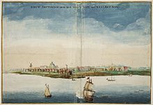
A pen-and-ink view of New Amsterdam,[5] drawn on-the-spot and discovered in the map collection of the Austrian National Library of Vienna in 1991, provides a unique view of Nieuw Amsterdam as it appeared from Capske (small Cape) Rock in 1648. Capske Rock was situated in the water close to Manhattan between Manhattan and Noten Eylant, which signaled the start of the East River roadstead.
 The Fall of New Amsterdam, by Jean Leon Gerome Ferris, showing Peter Stuyvesant (left of center, with wooden leg) standing on shore among residents of New Amsterdam who are pleading with him not to open fire on the English who have arrived in warships waiting in the harbor to claim the territory for England.
New Amsterdam received municipal rights on February 2, 1653 thus becoming a city, (Albany, then named Beverwyck, received its city rights in 1652).
On August 22, 1654, the first Ashkenazic Jews arrived with West India Company passports from Amsterdam to be followed in September by a sizable group of Sephardic Jews, without passports, fleeing from the Portuguese reconquest of Dutch possessions in Brazil. The legal-cultural foundation of toleration as the basis for plurality in New Amsterdam superseded matters of personal intolerance or individual bigotry. Hence, and in spite of certain private objections (including that of director-general Peter Stuyvesant), the Sephardim were granted permanent residency on the basis of "reason and equity" in 1655. Nieuw Haarlem (now known as Harlem) was formally recognized in 1658.
On August 27, 1664, while England and the Dutch Republic were at peace, four English frigates sailed into New Amsterdam's harbor and demanded New Netherland's surrender, whereupon New Netherland was provisionally ceded by director-general Peter Stuyvesant. This resulted in the Second Anglo-Dutch War, between England and the Dutch Republic. In June 1665, New Amsterdam was reincorporated under English law as New York City, named after the Duke of York (later King James II). He was brother of the English King Charles II, who had been granted the lands.
In 1667 the Treaty of Breda ended the conflict. The Dutch did not press their claims on New Netherland. In return, they were granted the tiny Island of Run in North Maluku, rich in nutmegs and the guarantee for the factual possession of Suriname, that year captured by them.
In July 1673, During the Third Anglo-Dutch War, the Dutch occupied New York City and renamed it New Orange. Anthony Colve was installed as the first Governor. Previously there had only been West India Company Directors. After the signing of the Treaty of Westminster in November 1674, the city was relinquished to the English and the name reverted to "New York". Suriname became an official Dutch possession in return.
 New Orange, c. 1674 (looking approximately north; the canal in the centre of the image (today's Broad St.) runs roughly north-south)
Maps of New Amsterdam
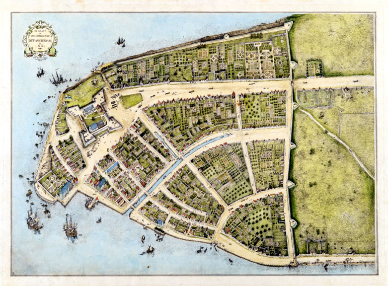
 The original city map of New Amsterdam called Castello Plan from 1660
(the bottom left corner is approximately south, while the top right corner is approximately north) Redraft of the Castello Plan, drawn in 1916
New Amsterdam's beginnings, unlike most other colonies in the New World, were thoroughly documented in city maps. During the time of New Netherland colonization, the Dutch were Europe's pre-eminent cartographers. Moreover, as the Dutch West India Company's delegated authority over New Netherlander was threefold, maintaining sovereignty on behalf of the States General, generating cash flow through commercial enterprise for its shareholders and funding the province's growth, its directors regularly required that censuses be taken. These tools to measure and monitor the province's progress were accompanied by accurate maps and plans. These surveys, as well as grassroots activities to seek redress of grievances,[5] account for the existence of some of the most important of the early documents.[6]
There is a particularly detailed city map called the Castello Plan. Virtually every structure in New Amsterdam at the time is believed to be represented, and by a fortunate coincidence it can be determined who resided in every house from the Nicasius de Sille List of 1660, which enumerates all the citizens of New Amsterdam and their addresses.[7]
The city map known as the Duke's Plan probably derived from the same 1660 census as the Castello Plan. The Duke's Plan includes the earliest suburban development on Manhattan (the two outlined areas along the top of the plan). The work was created for James (1633–1701), the duke of York and Albany, after whom New York City and New York State's capital Albany was named, just after the seizure of New Amsterdam by the English.[8] After that provisional relinquishment of New Netherland, Stuyvesant reported to his superiors that he "had endeavored to promote the increase of population, agriculture and commerce...the flourishing condition which might have been more flourishing if the now afflicted inhabitants had been protected by a suitable garrison...and had been helped with the long sought for settlement of the boundary, or in default thereof had they been seconded with the oft besought reinforcement of men and ships against the continual troubles, threats, encroachments and invasions of the English neighbors and government of Hartford Colony, our too powerful enemies."
The existence of these city maps has proven to be very useful in the archaeology of New York. For instance, the excavation of the Stadthuys (City Hall) of New Amsterdam had great help in finding the exact location of the building from the Castello map.[9]
Legacy
 Early 20th century Dutch Revival buildings on S William Street in lower Manhattan recall the Dutch origins of the city. The original 17th century architecture of New Amsterdam has completely vanished (affected by the fires of 1776 and 1835),[10][11] leaving only archaeological remnants.
The presentation of the legacy of the unique culture of 17th century New Amsterdam remains a concern of preservationists and educators. The National Park Service celebrated in 2009 the 400th anniversary of the Henry Hudson's 1609 voyage on behalf of the Dutch with the New Amsterdam Trail.[12][13]
Writer Elizabeth Bear published the New Amsterdam Series, detective stories taking place in an alternative history where the city remained Dutch until the Napoleonic Wars and retained its name also afterwards.
See also
- Director-General of New Netherland
- Roosevelt family
- New York: A Documentary Film
- Holland Society of New York
Notes
- ^ Nieuwe Wereldt ofte Beschrijvinghe van West-Indien, uit veelerhande Schriften ende Aen-teekeningen van verscheyden Natien (Leiden, Bonaventure & Abraham Elseviers, 1625) p.83: "/in den jare 1609 sonden de bewindt-hebbers van de gheoctroyeerde Oost-Indischische compagnie het jacht de halve mane/ daer voor schipper ende koopman op roer Hendrick Hudson[...]"("in the year 1609 the administrators of the East Indies Company sent the half moon captained by the merchant Hudson[...]")
- ^ "New York and its origins - Legend and reality". http://users.skynet.be/newyorkfoundation/US/the_birth_of_new_york.html.
- ^ a b Stratton, Eugene A. (1986). Plymouth Colony: Its History & People, 1620–1691. Salt Lake City: Ancestry Incorporated. ISBN 0916489132. http://books.google.com/?id=17zCU76ZtH0C. (page 20).
- ^ According to a calculation by the International Institute of Social History, Amsterdam at International Institute of Social History, Amsterdam, Netherlands
- ^ a b de Koning, Joep M.J. (July/August 2000). "From Van der Donck to Visscher". Mercator's World. http://web.archive.org/web/20030630211837/mercatorsworld.com/article.php3?i=75. Retrieved 2008-01-17.
- ^ Robert Augustyn, "Maps in the making of Manhattan" Magazine Antiques, September 1995. URL accessed on December 15, 2005.
- ^ Several reproductions of the Castello plan can be found on-line: New Netherland Project, New York Public Library, Wikimedia Commons. Colored versions from 1916 can be found here: New York University and here:New York Historical Society. A "Digital redraft of the Castello Plan of New Amsterdam in New Netherland in 1660" is an interactive map that can be found here: [1]. This map allows you to click in various places to learn more about the ownership and use of the land and buildings. All URLs accessed on February 17, 2010. A Google Earth File of the Castello Plan is posted here:[2].
- ^ An image of the Duke's map can be found on-line at the British Library site: THE BRITISH LIBRARY URL accessed on December 15, 2005.
- ^ A slideshow of the famous Stadt Huys dig, a landmark archaeological excavation of one of the central blocks of New Amsterdam, can be found here: [3]. A 17-century picture of the Stadthuys can be found here: [4]. Both URLs accessed on February 2, 2011.
- ^ NY Public Library Picture Collection. "Map of Great Fire 1776". http://www.bklyn-genealogy-info.com/Map/1776greatfire.html. Retrieved 2011-02-02.
- ^ CUNY. "Map of Damages - 1835". http://www.virtualny.cuny.edu/Search/search_res_image.php?id=502. Retrieved 2011-02-02.
- ^ "The New Amsterdam Trail". National Park Service, New York Harbor Parks. 2009. http://www.nyharborparks.org/visit/tour-new-amsterdam.html.
- ^ "The Henry Hudson 400 Foundation". http://www.henryhudson400.com/home.php.
External links
- The New Amsterdam Trail, a downloadable audio walking tour of Lower Manhattan
- Nieuw Amsterdam to New York, an audio history from the National Parks of New York Harbor Conservancy
- New Amsterdam from the New Netherland Project
- From Van der Donck to Visscher: a 1648 view of New Amsterdam, discovered in Vienna in 1991
- Background on the Native Americans of the area
Dutch Empire Colonies and trading posts of the Dutch East India Company (1602-1798) GovernoratesAmbon · Banda · Batavia · Cape Colony · Ceylon · Coromandel · Formosa · Northeast coast of Java · Makassar · Malacca · MoluccasDirectoratesCommandmentsResidenciesSettlements with an opperhoofdColonies and trading posts of the Dutch West India Company (1621-1792) Colonies in the AmericasAcadia · Berbice† · Cayenne · Curaçao and Dependencies · Demerara · Essequibo · Brazil · New Netherland · Pomeroon · Sint Eustatius and Dependencies · Suriname‡ · Tobago · Virgin IslandsTrading posts in Africa† Governed by the Society of Berbice · ‡ Governed by the Society of SurinameSettlements of the Noordsche Compagnie (1614-1642) SettlementsColonies of the Kingdom of the Netherlands (1815-1962) Until 1825Until 1853Until 1872Until 1945Until 1954Until 1962† Became constituent countries of the Kingdom of the Netherlands; Suriname gained full independence in 1975, Curaçao and Dependencies was renamed to the Netherlands Antilles, which was eventually dissolved in 2010.Kingdom of the Netherlands (1954-Present) Constituent countriesPublic bodies of the NetherlandsCategories:- New Netherland
- Colonial United States (Dutch)
- 1620s establishments
- History of New York City
- Historic Jewish communities
- 1664 disestablishments
- Pre-state history of New York


Wikimedia Foundation. 2010.