- Mount Storm Lake
-
Mount Storm Lake 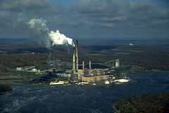
Mount Storm Lake and Power Plant Location Grant County, West Virginia Coordinates 39°12′28″N 79°15′45″W / 39.20778°N 79.2625°WCoordinates: 39°12′28″N 79°15′45″W / 39.20778°N 79.2625°W Lake type reservoir Primary inflows Stony River Primary outflows Stony River Basin countries United States Surface area 1,200 acres (490 ha) Surface elevation 3,244 ft (989 m) Mount Storm Lake — also known as New Stony River Reservoir — is a 1,200 acre (4.9 km²) reservoir created in 1965 on the Stony River in Grant County, West Virginia.[1]
Mount Storm Lake serves as a cooling pond for the Dominion 1,600 megawatt Mount Storm Power Station, which provides electricity to more than two million customers in Northern Virginia. The reservoir stands at an altitude of 3,244 feet (983 m).
Recreation
 Oblique air photo of Mount Storm Lake and nearby wind turbines, facing northwest in August 2011.
Mount Storm Lake is a popular local and tourist destination. When Dominion Virginia Power is using the reservoir for cooling, it keeps Mount Storm Lake at a warm temperature that makes it perfect for swimming, boating, and water activities even in cooler weather. The reservoir's water is also extremely clear, with the light available on an average overcast day allowing swimmers to clearly see its bottom at depths of at least five to six feet.[citation needed]
Mount Storm Lake, due to the temperatures, is a popular diving destination and training ground for scuba divers. The reservoir, which is in the upper 80s to 90s in the summer and rarely drops below fifty in the winter is outfitted with dive platforms at 30, 50, 75, and 120 feet and is regularly used by divers as a place to test equipment, maintain skill, enjoy a dive, and further training.
The lake's location on the Allegheny Front, one of the windiest spots east of the Mississippi, makes it an excellent destination for small boat sailing. There is a public boat ramp at the north end of the lake just off Highway 93. More than 40 of Virginia Power's electrical generating wind turbines are visible from the lake.
References
- ^ West Virginia Division of Natural Resources, South Charleston, WV (2003). "Mount Storm Lake."
Potomac River system
Cities and towns | Bridges | Islands | Tributaries | Variant names
District of Columbia | Maryland | Pennsylvania | Virginia | West Virginia
Streams shown as: Major tributaries • subtributaries • (subsubtributaries) • (subsubsubtributaries)Lakes and reservoirsCategories:- Chesapeake Bay Watershed
- Geography of Grant County, West Virginia
- Reservoirs in West Virginia
- Potomac River Watershed
- Potomac Highlands geography stubs


Wikimedia Foundation. 2010.