- Chhatarpur District
-
This article is about the district. For its eponymous headquarters, see Chhatarpur.
Chhatarpur district
छतरपुर जिला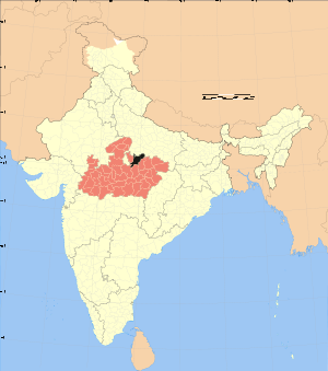
Location of Chhatarpur district in Madhya PradeshState Madhya Pradesh,  India
IndiaAdministrative division Sagar division Headquarters Chhatarpur Area 8,687 km2 (3,354 sq mi) Population 1,474,633 (2001) Population density 170 /km2 (440 /sq mi) Literacy 53.4 Sex ratio 869 Lok Sabha Constituencies Khajuraho Official website Chhatarpur District (Hindi: छतरपुर जिला) is a district of Madhya Pradesh state of central India. The town of Chhatarpur is the district headquarters.
Contents
Geography
Chattarpur district located at 24.06° & 25.20°N 78.59° & 80.26° E respectively. The district has an area of 8,687 km².Chhatarpur District is bounded by Uttar Pradesh state to the north, and the Madhya Pradesh districts of Panna to the east, Damoh to the south, Sagar to the southwest, and Tikamgarh to the west. Chhatarpur District is part of Sagar Division.[1]
History
Before Indian Independence, present-day Chhatarpur district consisted of a number of princely states, including Bijawar, Chhatarpur, Gaurihar, Alipura, and Lugasi, along with most of Charkhari and portions of Panna and Ajaigarh. After independence, the rulers of the states acceded to the Government of India, and the district became part of the new state of Vindhya Pradesh. Vindhya Pradesh was merged into Madhya Pradesh on November 1, 1956. Nowgaon was declared capital of Madhya Pradesh, after six month Bhopal became the capital of Madhya Pradesh.
Economy
In 2006 the Ministry of Panchayati Raj named Chhatarpur one of the country's 250 most backward districts (out of a total of 640).[2] It is one of the 24 districts in Madhya Pradesh currently receiving funds from the Backward Regions Grant Fund Programme (BRGF).[2]
Demographics
According to the 2011 census Chhatarpur District has a population of 1,762,857,[3] roughly equal to the nation of The Gambia[4] or the US state of Nebraska.[5] This gives it a ranking of 271st in India (out of a total of 640).[3] The district has a population density of 203 inhabitants per square kilometre (530 /sq mi) .[3] Its population growth rate over the decade 2001-2011 was 19.54 %.[3] Chhattarpur has a sex ratio of 884 females for every 1000 males,[3] and a literacy rate of 64.9 %.[3]
Chhatarpur district has a population of 1,474,633 (2001 census), a 27% increase from its 1991 population of 1,158,853.[1]
Languages
Vernaculars include Bharia, a Dravidian language spoken by at least 200 000 members of the Bharia tribe and written in the Devanagari script.[6]
Places of interest
The district is home to Khajuraho, the famous temple city created by the Chandela clan of Rajputs in the tenth century. Other notable locations are Jatashankar, Panna National Park, Bambar Baini Tample in Laundi, Arjunkund, Naogaon Nowgong, Maharajpur, Raneh Falls and Ken Gharial Sanctuary, Bijawar, Mata Temple at Harpalpur, and Hanuman Tauria.
Notable persons from the district
- Asgari Bai - Dhrupad singer and recipient of Padma Shri
- Babu Gulabrai - Hindi writer
[[File:== Memorable personalities ====
- Satyavrat Chaturvedi -- MP
- Balendu Shukla-- Famous enviourmental activist and animal saver
- Virendra Khatik---- MP Chhatarpur seat
- Jitendra Singh --- MP khajuraho seat
- Shivnarayan Khare--- Famous Yog teachar
- Dr. K.C. Jain----- Famous Yog teachar
- B.L. Mishra --- Famous Lawyer & writer
- Ashish Khare---- Famous journalist (Dainik Bhasker)
- Dr. rajjab Khan--- Famous journalist
- Dr. Ajay Dosaj --- Famous journalist
- Madhur Mishra--- Famous journalist-(FREE PRESS JOURNAL)]]Bundelkhand - Wikipedia
References
- ^ a b "Chhatarpur". Chhatarpur district administration. http://chhatarpur.nic.in/. Retrieved 2010-08-18.
- ^ a b Ministry of Panchayati Raj (September 8, 2009). "A Note on the Backward Regions Grant Fund Programme". National Institute of Rural Development. http://www.nird.org.in/brgf/doc/brgf_BackgroundNote.pdf. Retrieved September 27, 2011.
- ^ a b c d e f "District Census 2011". Census2011.co.in. 2011. http://www.census2011.co.in/district.php. Retrieved 2011-09-30.
- ^ US Directorate of Intelligence. "Country Comparison:Population". https://www.cia.gov/library/publications/the-world-factbook/rankorder/2119rank.html. Retrieved 2011-10-01. "Gambia, The 1,797,860 July 2011 est."
- ^ "2010 Resident Population Data". U. S. Census Bureau. http://2010.census.gov/2010census/data/apportionment-pop-text.php. Retrieved 2011-09-30. "Nebraska 1,826,341"
- ^ M. Paul Lewis, ed (2009). "Bharia: A language of India". Ethnologue: Languages of the World (16th edition ed.). Dallas, Texas: SIL International. http://www.ethnologue.com/show_language.asp?code=bha. Retrieved 2011-09-28.
External links
Divisions & Districts of Madhya Pradesh · 
Bhopal Division: Chambal Division: Gwalior Division: Ashoknagar · Datia · Guna · Gwalior · Shivpuri
Indore Division: Jabalpur Division: Narmadapuram Division: Betul · Harda · Hoshangabad
Rewa Division: Sagar Division: Chhatarpur · Damoh · Panna · Sagar · Tikamgarh
Shahdol Division: Ujjain Division: Cities and towns in Sagar Division Chhatarpur district Bada Malhera • Barigarh • Bijawar • Buxwaha • Chandla • Chhatarpur • Garhi-Malhara • Ghuwara • Harpalpur • Laundi • Maharajpur • Nowgaon • Rajnagar • SataiDamoh district Panna district Sagar district Bina Etawa • Bina Railway Colony • Deori • Dhana • Garhakota • Khurai • Makronia • Mandi Bamora • Rahatgarh • Rehli • Sagar Cantonment • Sagar • Shahgarh • ShahpurTikamgarh district Badagaon • Baldeogarh • Jatara • Jeron Khalsa • Kari • Khargapur • Lidhorakhas • Niwari • Orchha • Palera • Prithvipur • Taricharkalan • TikamgarhRelated topics Coordinates: 24°54′57″N 79°34′56″E / 24.915709°N 79.582214°E


Wikimedia Foundation. 2010.