- Chhindwara District
-
This article is about the district. For its eponymous headquarters, see Chhindwara.
Chhindwara district
छिन्दवाड़ा जिला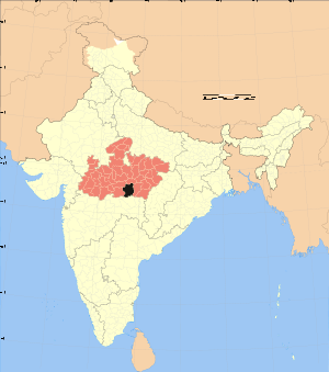
Location of Chhindwara district in Madhya PradeshState Madhya Pradesh,  India
IndiaAdministrative division Jabalpur Headquarters Chhindwara Area 11,815 km2 (4,562 sq mi) Population 18,48,882 (2001) Lok Sabha Constituencies Chhindwara Official website 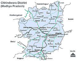 Map of Chhindwara District
Chhindwara district (Hindi: छिन्दवाड़ा जिला) is one of the districts of Madhya Pradesh state of India, and Chhindwara town is the district headquarters. The district is part of Jabalpur Division.
Contents
General information
Chhindwara District ranks 1st in area (11,815 km².) in Madhya Pradesh State and occupies 3.85% of the area of the state. Chhindwara district was formed on 1 November 1956. It is located on the South-West region of 'Satpura Range of Mountains'. It is spread from 21.28 to 22.49 Deg. North (longitude) and 78.40 to 79.24 Deg. East (latitude) and spread over an area of 11,815 km². This district is bound by the plains of Nagpur District (in Maharashtra State) on the South, Hoshangabad and Narsinghpur Districts on the North, Betul District on the West and Seoni Districts on the East. The land of Mandraha's sector is situated in village Nonia Karbal district of chhindwara. Kamlesh and Ramesh Mandraha are two brothers is here..
Divisions
The District is divided into 11 Tahsils (Chhindwara, Parasia, Junnardeo, Tamia, Amarwara, Chourai, Bicchua, Sausar,Umreth,Mohkhed and Pandhurna), 12 Development Blocks (Chhindwara, Parasia, Junnardeo,Damua, Tamia, Amarwara, Chourai, Bicchua, Harrai, Mohkhed, Sausar and Pandhurna). There are 9 Nagar Palikas (Chhindwara, Parasia, Junnardeo,Damua and Pandhurna), 8 Nagar Panchayats (Sausar, Amarwara, Chandameta Butaria, Newton Chikli, Harrai, Mohgaon, Chourai, and Lodhikheda). Apart from this there are 10 small towns (Dighawani, Jatachapar, Iklehara, Pagara, Kalichapar, Damua, Pala Chourai, Bhamori, Ambada and Badkuhi).
Demographics
According to the 2011 census Chhindwara District has a population of 2,090,306,[1] roughly equal to the nation of Macedonia[2] or the US state of New Mexico.[3] This gives it a ranking of 218th in India (out of a total of 640).[1] The district has a population density of 177 inhabitants per square kilometre (460 /sq mi) .[1] Its population growth rate over the decade 2001-2011 was 13.03 %.[1] Chhindwara has a sex ratio of 966 females for every 1000 males,[1] and a literacy rate of 72.21 %.[1]
There are 1,984 villages in the district, out of which 1,903 villages are inhabited. The district is divided into 19 Revenue Circles, 319 Patwari Halkas. There are 808 Panchayats in the district. 'Chhindwara' is the Parliamentary Constituency in the district and there are 8 Assembly Segments (Jamai, Chhindwara, Parasia, Damua, Amarwara, Chourai, Sausar and Pandhurna). As per Census 2001 the total population of Chhindwara town is 1,22,309 and of the district is 18,48,882 with a population density of 156 people per km². There are 953 females for every 1000 males. The sex ratio of Rural Chhindwara is more (962) than that of Urban Chhindwara (926). As per Census 2001, the average literacy rate of the district is 66.03%, which is above the average of the MP state's 64.08%. The literacy rate in the rural area of the district is 60.76% and that of urban area is 81.46%.
Languages
People speak multiple languages, including: Bagheli, which has a lexical similarity of 72-91% with Hindi[4] (compared to 60% for German and English)[5] and is spoken by about 7 800 000 people in Bagelkhand;[4] and Bharia, a Dravidian language spoken by at least 200 000 members of the Bharia tribe and written in the Devanagari script.[6]
Geography
From the Geographical point of view Chhindwara district can be divided into three main regions - 1) The western region consists two major town junnordeo & parasia, 2) the central region consisting of Chhindwara, Southern part of Amarwara region and Northern part of Sausar region. This region is also known as the Satpura mountain region and 3) The third region is mostly the Northern region consisting of hilly terrain.
The geographical height of district varies from 1,550 ft (470 m) to 3,820 ft (1,160 m) above sea level with an average elevation of 2215 feet (675 m). There are five major rivers which flow through the district namely Kanhan, Pench, Jam, Kulbehra, Shakkar and Doodh. Kanhan river flows in the Southern direction through the western parts of Chhindwara Tahsil and mixes with the Wenganga river. Jam river flows mostly through the Sausar region and joins with the Kanhan river. Pench river flows in the border areas of Chhindwara and Seoni Districts and mixes with the Kanhan river in Nagpur District. Kulbehra river starts at Umreth and flows through Chhindwara and Mohkhed and joins with Pench river. Around 4212.556 km². area of the district is covered under forest. Bamboo, Teak, Harra, Saalbeej, Tendu Patta are the major forest wealth.
Climate
Chhindwara has a subtropical climate. Like most of north India it has a hot dry summer (April–June) followed by monsoon rains (July–September) and a cool and relatively dry winter. Average annual rainfall is 1,183 mm. Minimum temperature during winder is 4 to 6 degree Celsius while maximum temperature during summer is 38 to 42 degree Celsius.
History
History records the place from the time of the rule of King Bakht Bulund, whose kingdom was spread over the Satpura range of hills and it is believed that his rule was up to the 3rd Century. One ancient plaque, belonging to "Rashtrakut" dynasty, found in "Neelkanth" village. This dynasty ruled up to the 7th Century. Then came the Gondwana dynasty which ruled the area with Deogarh as the capital. King 'Jatav' of 'Gond' community has built the Devgarh fort. King Bakht Bulund was most powerful in the dynasty and he has adopted Islam as his religion during the rule of Emperor Aurangzeb. Later power changed many hands and finally 'Maratha rule' ended in 1803. On September 17, 1803, British East India Company had taken over this kingdom by defeating Raghoji II Bhonsle, starting the British rule. After Independence 'Nagpur' was made the capital of Chhindwara District, and on November 1, 1956 this district was re-constituted with Chhindwara as the capital.
Industries
Following are few recognizable industries that have contributed to the industrial development of Chhindwara:
Hindustan Unilever Limited is a multinational company, originally from England. Earlier this company's name was Hindustan Lever Limited. Chhindwara Hindustan Unilever Limited is situated at village Lahgadua, 5 km from Chhindwara. This company has completed 75 years in 2008. There are 210 workers in Hindustan Unilever, who work in 3 shifts. The Chhindwara factory produces 3 main products: Rin washing soap, Wheel washing powder and Surf Excel washing powder. It is the only factory of Hindustan Unilever in Madhya Pradesh. In the year 2007 the production was 70,000 units.[citation needed]
Raymond Group The Raymond Chhindwara plant, set up in 1991, is a state-of-the-art integrated manufacturing facility located 65 km away from Chhindwara. Built on 100 acres (0.40 km2) of land, the plant produces premium pure wool, wool blended and polyester viscose suiting. This plant has achieved a record production capacity of 14.65 million meters, giving it the distinction of being the single largest integrated worsted suiting unit in the world.
Spices Park India's first spice park was opened in Chhindwara on 25th Feb 2009. The park, first in a series of seven parks planned by the Spices Board is being set up with an investment of Rs 20 cr. The initial phase of the park consists of a Garlic Dehydration Plant set up by the Spices Board and a Steam Sterilization Unit set up by STCL Ltd., a public sector company. KITCO is the technical consultants for the entire project. The park has come up in an area of 18 acres (73,000 m2) in Laas village, Umranala, near Chhindwara in Madhya Pradesh on Chhindwara-Nagpur Highway. COAL MINES:- JUNNORDEO situated about 50 km from chhindwara, it is the head office of kanhan arEa of WCL. It have Asia largest coal wash plant known as coal washry. It have around 15 coal mines in kanhan arEa.It having a big railway coal transportation & its have own importance in railways. Coal Mines: Parasia, situated about 30 km from Chhindwara, is known as the "Coal Mines Belt". There were 24 mines in this area, of which 20 mines are still working. The principal mines are: Eklahara Mines, Burkuhi Mines, Chandametta Mines, Newton Mines, Donger Chikhali Mines, Mahadev Puri Mines. Ravanwara Mines, Ravanwara Khash, Vishnu Puri 11 No., Vishnu Puri 12 No., Chhinda Mines, Setiya Mines, Shivpuri Mines, Shivpuri Mines, Chhury Mines, Mathani Mines, Thisgora Mines, Nahariya Mines, Pench Mines, and Urdhan Project.
Amongst other large scale industries are, Super Pack (Bajaj) at Village Sawli near Sausar, Bhansali Engineering Polymers at village Satnur near Sausar, P.B.M.Polytex Ltd. at village Borgaon near Sausar and Suryawanshi Spinning Mills at village Rajna near Pandhurna.
Tourism
Prominent Tourist Spots in the District include Patalkot, Tamia, Tribal Museum, Chota Mahadev Cave, Devgarh Fort, Nadadwari, Hot Water Spring at Anhoni and Radhadevi Caves and Jam Sanvli Temple (Near Sausar), Hiraman tiwari dadaji's samadhi temple, Kherapati devi mandir, chandradev mandir (Hindu) or chandshah vali (Muslim) dargah chandametta,Mandir or Masjid Eklehra, Hinglaj devi mandir Gudi-ambara. These tourist destinations are listed here on Wikilink of Chhindwara.
References
- ^ a b c d e f "District Census 2011". Census2011.co.in. 2011. http://www.census2011.co.in/district.php. Retrieved 2011-09-30.
- ^ US Directorate of Intelligence. "Country Comparison:Population". https://www.cia.gov/library/publications/the-world-factbook/rankorder/2119rank.html. Retrieved 2011-10-01. "Macedonia 2,077,328 July 2011 est."
- ^ "2010 Resident Population Data". U. S. Census Bureau. http://2010.census.gov/2010census/data/apportionment-pop-text.php. Retrieved 2011-09-30. "New Mexico - 2,059,179"
- ^ a b M. Paul Lewis, ed (2009). "Bagheli: A language of India". Ethnologue: Languages of the World (16th edition ed.). Dallas, Texas: SIL International. http://www.ethnologue.com/show_language.asp?code=bfy. Retrieved 2011-09-28.
- ^ M. Paul Lewis, ed (2009). "English". Ethnologue: Languages of the World (16th edition ed.). Dallas, Texas: SIL International. http://www.ethnologue.com/show_language.asp?code=eng. Retrieved 2011-09-28.
- ^ M. Paul Lewis, ed (2009). "Bharia: A language of India". Ethnologue: Languages of the World (16th edition ed.). Dallas, Texas: SIL International. http://www.ethnologue.com/show_language.asp?code=bha. Retrieved 2011-09-28.
External links

Hoshangabad district Narsimhapur district Betul district 
Seoni district  Chhindwara district

Amravati district, Maharashtra Nagpur district, Maharashtra Divisions & Districts of Madhya Pradesh · 
Bhopal Division: Chambal Division: Gwalior Division: Ashoknagar · Datia · Guna · Gwalior · Shivpuri
Indore Division: Jabalpur Division: Narmadapuram Division: Betul · Harda · Hoshangabad
Rewa Division: Sagar Division: Chhatarpur · Damoh · Panna · Sagar · Tikamgarh
Shahdol Division: Ujjain Division: Cities and towns in Jabalpur Division Balaghat district Chhindwara district Amarwara • Ambada • Badkuhi • Barkuhi • Bhamodi • Chandameta-Butaria • Chaurai Khas • Chhindwara • Damua • Deogarh • Dighawani • Dongar Parasia • Harrai • Iklehra • Jamai • Jata Chhapar • Kali Chhapar • Lodhikheda • Mohgaon • Neuton Chikhli Kalan • Pal Chourai • Panara • Pandhurna • Patalkot • Sausar • Sethia • SirgoraJabalpur district Barela • Bhedaghat • Bilpura • Gun Carriage Factory Jabalpur • Gwarighat • Jabalpur • Jabalpur Cantonment • Majholi • Manegaon • Ordnance Factory Khamaria • Panagar • Patan • Pipariya • Shahpura • Sihora • Suhagi • Vehicle Fac. JabalpurKatni district Mandla district Narsinghpur district Seoni district Related topics Cities and towns
in other DivisionsPatalesver
The one more famous temple in Chhindwara.Whom name is patalesver temple.This is a many years ago find out this place.This is a shiv temple.In chhindwara the shivratri maila held here.In chhindwara a shivling find out in "Ground".
Categories:- Districts of Madhya Pradesh
- Chhindwara district
- Coal mining districts in India


Wikimedia Foundation. 2010.