- California State Route 156
Infobox road
state=CA
type=SR
route=156
section=456
maint=Caltrans 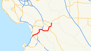
length_mi=25
length_round=0
length_ref= [ [http://www.dot.ca.gov/hq/structur/strmaint/brlog2.htm January 1, 2006 California Log of Bridges on State Highways] ]
direction_a=West
terminus_a=jct|state=CA|SR|1 near Castroville
direction_b=East
terminus_b=jct|state=CA|SR|152 near Hollister
previous_type=SR
previous_route=155
next_type=SR
next_route=158State Route 156 is a
state highway inCalifornia , USA, running from Castroville to State Route 152 near Hollister.This route is eligible for the State Scenic Highway System [http://www.leginfo.ca.gov/cgi-bin/displaycode?section=shc&group=00001-01000&file=260-284 CA Codes (shc:260-284)] ] .
Route description
The western terminus is at State Route 1 in Castroville. The eastern terminus is at State Route 152 near Hollister. It overlaps U.S. Route 101 for convert|8|mi|km between Prunedale, and San Juan Bautista. Route 156 passes through Monterey, San Benito, and Santa Clara Counties. Along with US 101, it is the quickest route from the
San Francisco Bay Area to theMonterey Peninsula .For its westernmost two miles (3 km), Route 156 is a freeway through Castroville, terminating at a Y-interchange with the Route 1 freeway. There is no direct access from Route 156 West to Route 1 North or Route 1 South to Route 156 East. Motorists who want to go from Route 1 South to Route 156 East can do so by using Route 183 South through Castroville. Traffic heading west on Route 156 can access Route 1 North by exiting at the Route 183 interchange and heading north.
History
The original portion of the route was defined in
1909 and ran from U.S. Route 101 to Hollister. In1933 , the remainder of the route (between Castroville and US 101 and between Hollister and Route 152) was added. It was signed as Route 156 by 1963, but was not part of the original 1934 state signage of routes.Planned Upgrades
Highway 156 experiences heavy truck traffic as it serves as a primary route for moving people and goods between the Monterey Peninsula and the rest of the state. It directly links with Highway 152, one of a small number of passable routes across the Coast Ranges between Monterey Bay and the Central Valley.
Monterey County
The westernmost segment from Highway 1 to Highway 101 in Prunedale is a heavily-traveled 2-lane section that has experienced numerous fatal crashes in recent years. Environmental studies are underway to upgrade this 5-mile (8 km) section to either a 4-lane highway or fully-controlled access expressway. The Transportation Agency for Monterey County and CALTRANS have narrowed the list of upgrade alternatives to one freeway and one expressway option. Alternative 11--the expressway option--will add a second carriageway to the existing road. Interchanges will be constructed at Castroville Boulevard and Cathedral Oaks Road, while Oak Hills Drive will be an at-grade intersection. Alternative 12--the freeway option--will build a new freeway to the south of the existing roadway with an interchange at Castroville Boulevard. Under this alternative, there will be no interchange with Cathedral Oaks Road or Oak Hills Drive. The existing Route 156 would be converted to a frontage road providing access to Cathedral Oaks Road and Oak Hills Drive. The environmental studies are expected to be complete in 2009, with the project slated for completion in 2015. [ [http://www.tamcmonterey.org/programs/hwyproj/hwy156.html TAMC Highway 156 Upgrades] ]
anta Clara County
CALTRANS is constructing a high-speed interchange at the eastern terminus of Highway 156 at Highway 152. Currently, Highways 152 and 156 approach an at-grade intersection from the west and south, respectively as 2-lane roads. At this junction, Highway 156 terminates and Highway 152 continues east as a 4-lane expressway. The project involves constructing ramps and bridges to create a directional interchange between Highway 156 and Highway 152. This project also includes widening roughly convert|1.5|mi|km of Highway 156 to four lanes from Route 152 to the Santa Clara/San Benito County line.
an Benito County
San Benito County and CALTRANS are conducting environmental studies for widening Highway 156 from two to four lanes between Highway 101 near San Juan Bautista and the Santa Clara County line. Interchanges are proposed with Highway 25 northwest of Hollister, Business Route 156 both north and southwest of Hollister, and Highway 101. The entire segment may be upgraded to freeway status to eliminate delays caused by numerous
traffic light s currently present in the Hollister area.Major intersections
:"Note: Except where prefixed with a letter,
postmile s were measured in 1964, based on the alignment as it existed at that time, and do not necessarily reflect current mileage. The numbers reset at county lines; the start and end postmiles in each county are given in the county column."External links
* [http://www.dot.ca.gov/hq/roadinfo/sr156 Caltrans: Route 156 highway conditions]
* [http://www.cahighways.org/153-160.html California Highways: Route 156]References

Wikimedia Foundation. 2010.