- Confederation Park
-
For other uses, see Confederation Park (disambiguation).For the square to the north of the park, see Confederation Square.
Confederation Park National Historic Site of Canada 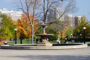
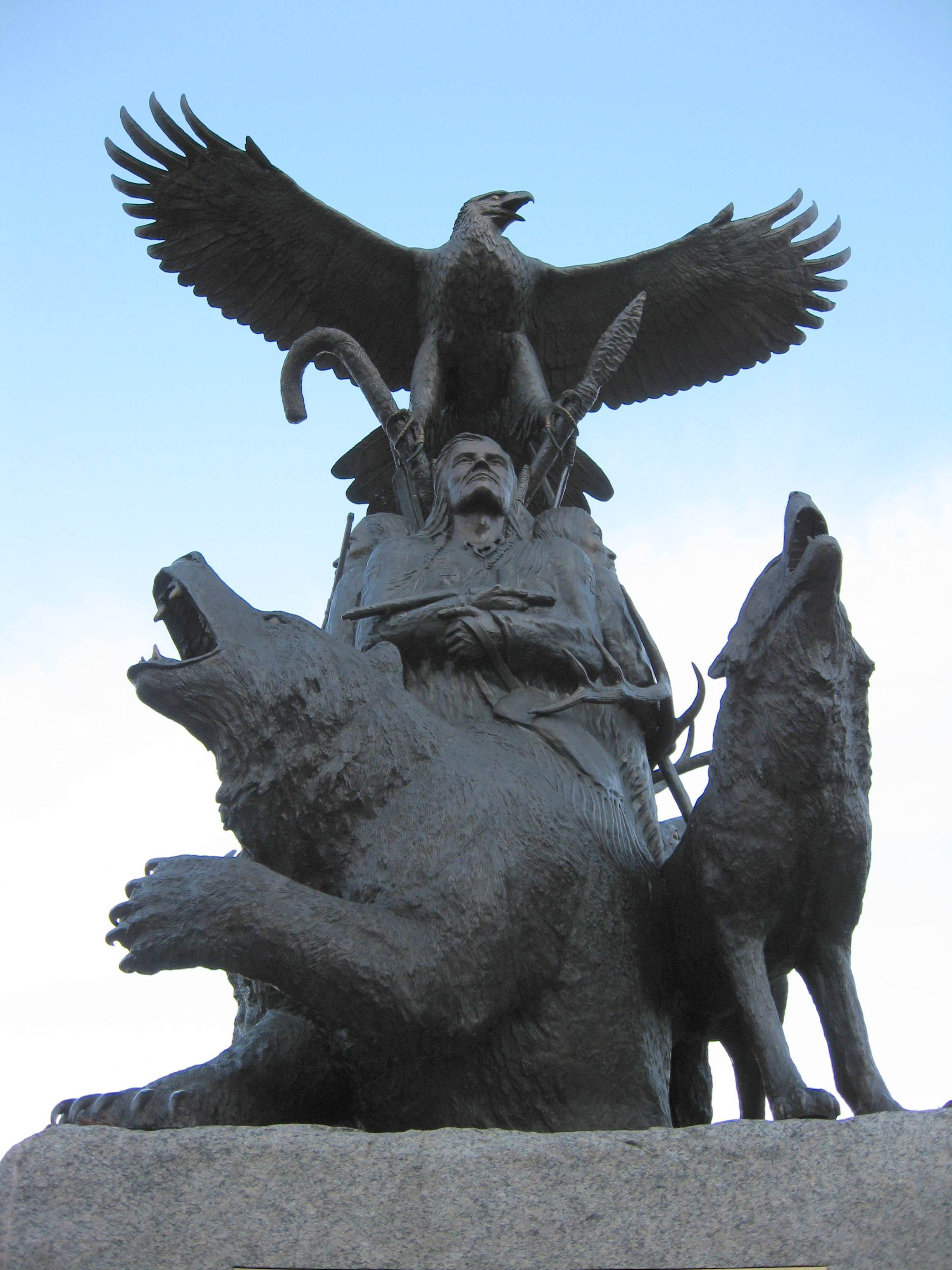
The fountain in Confederation ParkProvince Ontario Website 360 Panorama from OttawaKiosk.com  Monument to aboriginal War veterans in the park
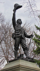 Statue to dead soldiers of the Boer War
Confederation Park (French: Parc de la Confédération) is a park in downtown Ottawa and a National Historic Site of Canada. It is bordered on the south by Laurier Avenue and Ottawa City Hall; on the east by the Rideau Canal; on the north by the Mackenzie King Bridge, the Rideau Centre and the National Arts Centre; and, to the west, by Elgin Street and the Lord Elgin Hotel.
Contents
Description
Confederation Park is one of the 'Capital' parks in Ottawa maintained by the National Capital Commission.[1] It is an urban park, with paved pathways, monuments and an open lawn on the eastern side for gatherings. It is basically flat in its topology. A large fountain is located in the center of the park. Constructed of Peterhead granite, it honors Colonel John By. The fountain was relocated from Trafalgar Square, London, where it had stood 1845 to 1939.[2] A twin of the fountain, which had also stood in Trafalgar Square, is located in Wascana Park, Regina).[3] The park also is the site of a totem pole donated to the City of Ottawa to commemorate British Columbia's 1971 centennial, the National Aboriginal Veterans Monument and a Boer War memorial statue.
The park is surrounded on all sides by large buildings. On the east, on the other side of the Canal, is the 'brutalist' modern skyscraper of Defence headquarters. On the south, across Laurier Avenue is the complex of Ottawa City Hall and the Ontario Court building. On the west, on Elgin, is the large Lord Elgin Hotel. To the north, the modern National Arts Centre complex can be seen.
The pathways through the park serve as a common shortcut for pedestrians heading from Elgin Street and/or Centretown to destinations to the north and east (the National Arts Centre, Rideau Street, Sussex Drive, the Rideau Centre and/or the Byward Market), since it is a more direct route than walking uphill on Elgin and Wellington Streets.
History
The area was part of Ottawa's downtown for many years, the site of businesses related to the nearby Rideau Canal, such as Dey's Boat Works. The location was the site of The Arena from 1908 to 1927, where the original Ottawa Senators ice hockey team played. The land bordering the canal was cleared in 1927, including the demolition of the arena. The land was used to build "The Driveway" roadway along the canal, as a scenic improvement of the capital.
Along Elgin Street, the location was occupied by the Roxborough Apartments, a luxury apartment complex that had once been home to many Ottawa elites, such as Prime Ministers William Lyon Mackenzie King and Louis St. Laurent. As part of the 1949 Greber Plan, the site was to be cleared for a "Confederation Park" along the Canal from Laurier Avenue to Wellington Street surrounded by public buildings.[4] The apartments and a number of buildings were expropriated and demolished by the federal government to build a "National Museum of Science" in 1965. The area north of the Mackenzie King bridge had already been cleared as part of the building of Confederation Square. That section was ultimately used for the construction of the National Arts Centre. In 1967, the Museum site was converted to parkland, to commemorate the Canadian Centennial (the 100th anniversary of Canadian Confederation).
From 1971 to 1993, the park was home to Ed Zelenak's massive sculpture, "Traffic." The controversial work was a large brown tube of fiberglass that was compared to a large worm or piece of dung, and led to much debate over modern art in Ottawa. It was later relocated to a more obscure location by the National Gallery.[5]
Events
In the summer, the Ottawa International Jazz Festival's main events are held here. In the winter, Winterlude uses the location for displays, events and its ice sculpture competition. Events of Canada Day are held at the site as well.[6] Other festivals that spill over from the neighbouring Cartier Square plaza in front of Ottawa City Hall use the park.
Other parks
There are several other parks in Canada sharing the name 'Confederation Park'. A 400 hectares (990 acres) urban park is located in Calgary, Alberta. Another is located in Hamilton, Ontario on the Lake Ontario waterfront. Kingston, Ontario's Confederation Park is also on the Lake Ontario waterfront by Kingston City Hall.
Occupy Ottawa
The Occupy movement's presence in Ottawa began on Saturday October 15, 2011 with around 500 people participating at Confederation Park. A march on Sussex Drive was held the second day, passing by the U.S. embassy. Around 75 people camped in tents, with the group planning to occupy the downtown park indefinitely. Many participants, prepared for the long haul, described Occupy Ottawa as a movement of presence, rather than just a protest.[7] [8]
See also
References
- ^ "Capital Parks to Discover". National Capital Commission. http://www.canadascapital.gc.ca/bins/ncc_web_content_page.asp?cid=16297-16299-24560-30166&lang=1. Retrieved September 16, 2010.
- ^ *Exploring Ottawa: an architectural guide to the nation's capital. Harold Kalman and John Roaf. Toronto: University of Toronto Press, 1983. pg. 46
- ^ "A Pair of Fountains from Trafalgar Square". The Art Fund. http://www.artfund.org/artwork/2766/a-pair-of-fountains-from-trafalgar-square. Retrieved September 16, 2010.
- ^ "Proposed Confederation Park of the Future". Ottawa Citizen: p. 58. April 29, 1949. http://news.google.com/newspapers?id=ghMvAAAAIBAJ&sjid=gdwFAAAAIBAJ&dq=airport%20parkway%20ottawa&pg=5764%2C8961550.
- ^ Stone, Jay (May 8, 1993). "Farewell, fair Worm, enjoy your traffic island.". The Ottawa Citizen (Ottawa, Ont.): p. p. F1.
- ^ "Confederation Park". ottawakiosk.com. http://www.ottawakiosk.com/attractions/confederation-park.html. Retrieved September 16, 2010.
- ^ "Occupy Canada protests persist as work week begins". cbc.ca. http://www.cbc.ca/news/canada/edmonton/story/2011/10/17/occupy-canada-wrap.html. Retrieved October 27, 2010.
- ^ "Occupy Ottawa movement 'to stay as long as it takes'". canada.com. http://www.canada.com/technology/Occupy+Ottawa+movement+stay+long+takes/5559664/story.html?id=5559664. Retrieved October 27, 2010.
External links
- Webcam from the Lord Elgin Hotel - Webcam overlooking Confederation Park.
- 360 Panorama from OttawaKiosk.com - 360 Degree picture of Confederation Park during Winterlude.
 National Historic Sites of Canada by location
Provinces Territories Northwest Territories · Nunavut · YukonOther countries France Category ·
  Portal ·
  WikiProject
Coordinates: 45°25′20″N 75°41′31″W / 45.422221°N 75.692024°W
Categories:- Parks in Ottawa


Wikimedia Foundation. 2010.