- Provinces of Thailand
-
Thailand 
This article is part of the series:
Politics and government of
ThailandSubdivisionsRelated issues
Thailand is divided into 76 provinces (Thai: จังหวัด, changwat, singular and plural, pronounced [tɕ͡āŋ.wàt]), which are geographically grouped into 6 regions. The capital Bangkok is not a province but a special administrative area and is included as the 77th province since it is administered at the same level as the other 76 provinces. The name of the provinces are the same as that of their respective capital cities. The only 6 provinces whose capitals are not the biggest cities in their provinces are Tak (Mae Sot is the biggest city), Pathum Thani (Rangsit is the biggest city), Songkhla (Hat Yai is the biggest city), Chonburi (Pattaya is the biggest city), Narathiwat (Su-ngai Kolok is the biggest city) and Prachuap Khiri Khan (Hua Hin is the biggest city).
Bangkok is both the highest population and the highest population density. The biggest province by area is Nakhon Ratchasima, the smallest Samut Songkhram. Ranong has the lowest population number, while Mae Hong Son has the lowest population density (facts according to the year 2000 census).
Each province is administered by a governor, who is appointed by the Ministry of Internal Affairs. The only exception is Bangkok, whose governor is elected by its population.
Thailand is subdivided into 878 districts (amphoe, อำเภอ). The fifty districts of Bangkok are called khet (เขต), but even in official documents they are sometimes misidentified as amphoe. The number of districts in each provinces varies, from three in the smallest provinces to fifty in Bangkok. Further subdivision levels are tambon (subdistricts) and finally, muban (villages). In Bangkok the tambon are called khwaeng.
Contents
List of provinces
A clickable map of Thailand exhibiting its provinces.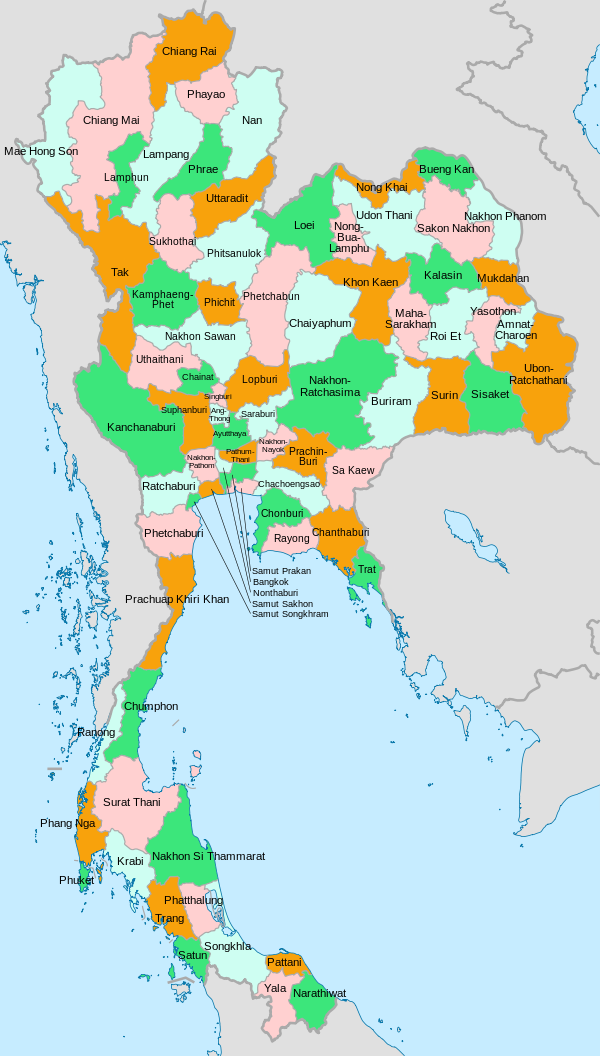

Seal Name Capital Population Area (km²) Density HDI ISO 
Bangkok (Krung Thep Maha Nakhon)
Special Governed DistrictBangkok (Krung Thep Maha Nakhon) 9,100,000 1,568.7 5,801 0.933 TH-10 
Samut Prakan Province Samut Prakan 1,126,485 1,004.1 1,121.9 0.825 TH-11 
Nakhon Nayok Province Nakhon Nayok 241,081 2,122.0 113.6 0.758 TH-26 
Nakhon Sawan Province Nakhon Sawan 1,090,379 9,597.7 113.6 0.752 TH-60 
Nonthaburi Province Nonthaburi 1,039,619 622.3 1,670.6 0.743 TH-12 
Pathum Thani Province Pathum Thani
(The largest city is Rangsit)853,649 1,525.9 559.4 0.805 TH-13 
Phra Nakhon Si Ayutthaya Province Phra Nakhon Si Ayutthaya 769,126 2,556.6 300.8 0.729 TH-14 
Ang Thong Province Ang Thong 269,419 968.4 278.2 0.720 TH-15 
Lopburi Province Lopburi 745,506 6,199.8 120.2 0.742 TH-16 
Sing Buri Province Sing Buri 232,766 822.5 283 0.739 TH-17 
Chainat Province Chainat 359,829 2,469.7 145.7 0.756 TH-18 
Saraburi Province Saraburi 575,053 3,576.5 160.8 0.798 TH-19 
Uthai Thani Province Uthai Thani 304,122 6,730.2 45.2 0.704 TH-61 
Kamphaeng Phet Province Kamphaeng Phet 674,027 8,607.5 78.3 0.725 TH-61 
Sukhothai Province Sukhothai 593,264 6,596.1 89.9 0.738 TH-64 
Phitsanulok Province Phitsanulok 792,678 10,815.8 73.3 0.724 TH-65 
Phichit Province Phichit 572,989 4,531.0 126.5 0.693 TH-66 
Phetchabun Province Phetchabun 965,784 12,668.4 76.2 0.745 TH-67 
Samut Songkhram Province Samut Songkhram 204,177 416.7 490 0.762 TH-75 
Samut Sakhon Province Samut Sakhon 466,281 872.3 534.5 0.758 TH-74 
Nakhon Pathom Province Nakhon Pathom 815,122 2,168.3 375.9 0.682 TH-73 
Suphan Buri Province Suphan Buri 855,949 5,358.0 159.8 0.744 TH-72 
Chonburi Province Chonburi
(The largest city is Pattaya)1,040,865 4,363.0 238.6 0.889 TH-20 
Rayong Province Rayong 522,133 3,552.0 147 0.761 TH-21 
Chanthaburi Province Chanthaburi 480,064 6,338.0 75.7 0.754 TH-22 
Trat Province Trat 219,345 2,819.0 77.8 0.675 TH-23 
Chachoengsao Province Chachoengsao 635,153 5,351.0 118.7 0.708 TH-24 
Prachinburi Province Prachinburi 406,732 4,762.4 85.4 0.755 TH-25 
Sa Kaeo Province Sa Kaeo 485,632 7,195.1 67.5 0.688 TH-27 
Nakhon Ratchasima Province Nakhon Ratchasima 2,565,117 20,494.0 125.2 0.815 TH-30 
Buriram Province Buriram 1,493,359 10,322.9 144.7 0.729 TH-31 
Surin Province Surin 1,375,257 8,124.1 169.3 0.751 TH-32 
Sisaket Province Sisaket 1,405,500 8,840.0 159 0.734 TH-33 
Ubon Ratchathani Province Ubon Ratchathani 1,803,754 16,112.6 111.9 0.800 TH-34 
Yasothon Province Yasothon 561,430 4,161.7 134.9 0.782 TH-35 
Chaiyaphum Province Chaiyaphum 1,095,360 12,778.3 85.7 0.748 TH-36 
Amnat Charoen Province Amnat Charoen 359,360 3,161.2 113.7 0.712 TH-37
N/A
Bueng Kan Province Bueng Kan 385,053 4,305 89.4 --- TH-38 
Nong Bua Lamphu Province Nong Bua Lamphu 482,207 3,859.0 125 0.714 TH-39 
Khon Kaen Province Khon Kaen 1,733,434 10,886.0 159.2 0.850 TH-40 
Udon Thani Province Udon Thani 1,467,158 11,730.3 125.1 0.885 TH-41 
Loei Province Loei 607,083 11,424.6 53.1 0.731 TH-42 
Nong Khai Province Nong Khai 498,651 3,027 164.7 0.755 TH-43 
Maha Sarakham Province Maha Sarakham 947,313 5,291.7 179 0.729 TH-44 
Roi Et Province Roi Et 1,256,458 8,299.4 151.4 0.732 TH-45 
Kalasin Province Kalasin 921,366 6,946.7 132.6 0.718 TH-46 
Sakon Nakhon Province Sakon Nakhon 1,040,766 9,605.8 108.3 0.705 TH-47 
Nakhon Phanom Province Nakhon Phanom 684,444 5,512.7 124.2 0.778 TH-48 
Mukdahan Province Mukdahan 310,718 4,339.8 71.6 0.728 TH-49 
Chiang Mai Province Chiang Mai 1,649,457 20,107.0 82.03 0.904 TH-50 
Lamphun Province Lamphun 413,299 4,505.9 91.7 0.729 TH-51 
Lampang Province Lampang 782,152 12,534.0 62.4 0.748 TH-52 
Uttaradit Province Uttaradit 464,474 7,838.6 59.3 0.711 TH-53 
Phrae Province Phrae 492,561 6,538.6 75.3 0.702 TH-54 
Nan Province Nan 475,614 11,472.1 41.5 0.705 TH-55 
Phayao Province Phayao 502,780 6,335.1 79.4 0.722 TH-56 
Chiang Rai Province Chiang Rai 1,129,701 11,678.4 96.7 0.716 TH-57 
Mae Hong Son Province Mae Hong Son 248,748 12,681.3 19.6 0.704 TH-58 
Tak Province Tak
(The largest city is Mae Sot)486,146 16,406.6 29.6 0.735 TH-63 
Ratchaburi Province Ratchaburi 791,217 5,196.5 152.3 0.726 TH-70 
Kanchanaburi Province Kanchanaburi 849,361 19,483.2 43.6 0.733 TH-71 
Phetchaburi Province Phetchaburi 435,377 6,225.1 69.9 0.798 TH-76 
Prachuap Khiri Khan Province Prachuap Khiri Khan
(The largest city is Hua Hin)494,299 6,367.6 77.6 0.868 TH-77 
Nakhon Si Thammarat Province Nakhon Si Thammarat 1,519,811 9,942.5 152.9 0.769 TH-80 
Krabi Province Krabi 336,210 4,708.5 71.4 0.805 TH-81 
Phang Nga Province Phang Nga 234,188 4,170.0 56.2 0.758 TH-82 
Phuket Province Phuket 348,504 543.0 641.82 0.921 TH-83 
Surat Thani Province Surat Thani 990,592 12,891.5 76.8 0.849 TH-84 
Ranong Province Ranong 161,210 3,298.0 48.9 0.678 TH-85 
Chumphon Province Chumphon 446,206 6,009.0 74 0.710 TH-86 
Songkhla Province Songkhla
(The largest city is Hat Yai)1,324,915 7,393.9 179.2 0.681 TH-90 
Satun Province Satun 247,875 2,479.0 100 0.655 TH-91 
Trang Province Trang 595,110 4,917.5 121 0.692 TH-92 
Phatthalung Province Phatthalung 498,471 3,424.5 145.6 0.713 TH-93 
Pattani Province Pattani 595,985 1,940.4 307.1 0.698 TH-94 
Yala Province Yala 415,537 4,521.1 91.9 0.687 TH-95 
Narathiwat Province Narathiwat
(The largest city is Su-ngai Kolok)662,350 4,475.0 148 0.636 TH-96 History
Before 1892
Many provinces date back to semi-independent local chiefdoms or kingdoms, which made up the Ayutthaya kingdom. As today, the provinces were created around a capital city (mueang), and included surrounding villages or satellite towns. The provinces were administered either by a governor, who was appointed by the king; or by a local ruling family, who were descendants of the old local kings and princes of that area and had been given this privilege by the central king. De facto the king did not have much choice but to choose someone from the local nobility or an economically strong man, as against these local power groups the administration would have become impossible. The governor wasn't paid by the king, but instead financed himself and his administration by imposing taxes by himself, thus effectively a kleptocracy. Every province was required to send an annual tribute to Bangkok.
The provinces were divided into four different classes. The first class were the border provinces. The second class were those that once had their own princely house. Third class were provinces that were created recently by splitting them from other provinces. Fourth class were provinces near the capital. Additionally tributary states like the principalities of Lannathai, the Laotian kingdoms of Vientiane and Luang Prabang, Cambodia, or the Malay sultanate Kedah were also part of the country, but with an even higher autonomy than the provinces. In this Mandala system the semi-independent countries sometimes were tributary to more than one country.
New provinces were created when the population of an area outgrew the administration, but also for political reasons if a governor became too dominant in a region former satellite cities were elevated to provincial status, as in the founding of the Maha Sarakham Province.
Reforms of the provincial administration started in the 1870s under increased pressure from the colonial states of the United Kingdom and France. Especially to the areas near the borders commissionaries were sent to have a stronger control on the provinces or tributary states.
Administrative reform of 1892
At the end of the 19th century King Chulalongkorn reformed the central government drastically. In 1892 the ministry, which previously had many overlapping responsibilities, was reorganized with clear areas as in western administrations. Prince Damrong Rajanubhab became minister of the Ministry of the North (Mahatthai), originally responsible for the northern administration. When the Ministry of the South (Kalahom) was dissolved in 1894, Prince Damrong became Minister of the Interior, responsible for the provincial administration of the whole country.
Starting in 1893 the already existing commissionarships in some parts of the country were renamed to superintendent commissioner (khaluang thesaphiban), and their area of responsibility was called monthon. In strategically important areas the monthon were created first, while in other areas the provinces kept their independence a bit longer. Several smaller provinces were reduced in status to a Amphoe (district) or even lower to a tambon (subdistrict) and included in a neighboring province, sometimes for administrative reasons, but sometimes also to remove an uncooperative governor.
In some regions rebellions broke out against the new administrative system, usually induced by the local nobility fearing their loss of power. The most notable was the Holy Man rebellion in 1902 in Isan, which even though it was at first a messianic doomsday sect, it also attacked government representative in the North-East. The provincial town Khemarat was even burned by the rebels. After a few months the rebellion fought back.
After 1916 the word changwat became common to use for the provinces, partly to distinguish them from the provincial capital city (Mueang or Amphoe Mueang), but also to stress the new administrative structure of the provinces.[1]
When Prince Damrong resigned in 1915, the whole country was subdivided into 19 monthon (including the area around Bangkok, which was however under the responsibility of another ministry until 1922), with 72 provinces.
In December 1915 King Vajiravudh announced the creation of regions (phak), each administered by a viceroy (upparat), to cover several monthon. Until 1922 four regions were established, however in 1925 they were dissolved again. At the same time several monthon were merged, in an attempt to streamline the administration and reduce the costs.
Since 1932
The monthon were finally dissolved when Thailand transformed from an absolute monarchy into a constitutional monarchy in 1932, making the provinces the top level administrative division again. Several smaller provinces were also abolished at that time. During World War II, several provinces around Bangkok were merged together, which was however undone after the war. The current province of Sukhothai was at first known as Sawankhalok; it was renamed to Sukhothai in 1939 (which is why the railway system goes to Sawankhalok city and not Sukhothai city). Also the province Kalasin was reestablished in 1947, after being dissolved in 1932.
In 1972 the two provinces Phra Nakhon and Thonburi were merged to form the special administrative area of Bangkok, which combines the tasks of the provinces with that of a municipality, including having an elected governor.
Starting in the second half of the 20th century some provinces were newly created by splitting them off from bigger provinces. In 1975, Yasothon province was split off from Ubon Ratchathani. In 1977, Phayao province was created from districts formerly part of Chiang Rai. In 1982, Mukdahan was split off from Nakhon Phanom. 1993 three provinces were created: Sa Kaeo (split from Prachinburi), Nongbua Lamphu (split from Udon Thani), and Amnat Charoen (split from Ubon Ratchathani). The newest province is Bueng Kan, which was split off fron Nong Khai effective March 23 2011.
See also
- Subdivisions of Thailand
- Seals of The Provinces of Thailand
- Amphoe
- Tambon
- List of Provinces of Thailand (with census data)
- ISO 3166-2:TH
References
- Tej Bunnag (1977). The provincial administration of Siam, 1892-1915: the Ministry of the Interior under Prince Damrong Rajanubhab. Kuala Lumpur; New York: Oxford University Press. ISBN 0195803434.
- Department of Provincial Administration
- Provinces of Thailand at statoids.com
Notes
- ^ "ประกาศกระทรวงมหาดไทย เรื่อง ทรงพระกรุณาโปรดเกล้า ฯ ให้เปลี่ยนคำว่าเมืองเรียกว่าจังหวัด" (in Thai). Royal Gazette 33 (0 ก): 51–53. 1916-05-28. http://www.ratchakitcha.soc.go.th/DATA/PDF/2459/A/51.PDF.
External links
Provinces of Thailand Capital: Bangkok North North-East Amnat Charoen · Bueng Kan · Buri Ram · Chaiyaphum · Kalasin · Khon Kaen · Loei · Maha Sarakham · Mukdahan · Nakhon Phanom · Nakhon Ratchasima · Nong Bua Lamphu · Nong Khai · Roi Et · Sakon Nakhon · Sisaket · Surin · Ubon Ratchathani · Udon Thani · YasothonCentral Ang Thong · Chai Nat · Kamphaeng Phet · Lop Buri · Nakhon Nayok · Nakhon Pathom · Nakhon Sawan · Nonthaburi · Pathum Thani · Phetchabun · Phichit · Phitsanulok · Phra Nakhon Si Ayutthaya · Samut Prakan · Samut Sakhon · Samut Songkhram · Saraburi · Sing Buri · Sukhothai · Suphan Buri · Uthai ThaniEast West South Chumphon · Krabi · Nakhon Si Thammarat · Narathiwat · Pattani · Phang Nga · Phatthalung · Phuket · Ranong · Satun · Songkhla · Surat Thani · Trang · YalaArticles on first-level administrative divisions of Asian countries Afghanistan · Armenia · Azerbaijan1 · Bahrain · Bangladesh · Bhutan · Brunei · Burma · Cambodia · People's Republic of China · Cyprus · Egypt1 · Georgia1 · India · Indonesia1 · Iran · Iraq · Israel · Japan · Jordan · Kazakhstan1 · North Korea · South Korea · Kuwait · Kyrgyzstan · Laos · Lebanon · Malaysia · Maldives · Mongolia · Nepal · Oman · Pakistan · Palestine · Philippines · Qatar · Russia1 · Saudi Arabia · Singapore · Sri Lanka · Syria · Republic of China (Taiwan) · Tajikistan · Thailand · Timor-Leste (East Timor)1 · Turkey1 · Turkmenistan · United Arab Emirates · Uzbekistan · Vietnam · Yemen1
1 Country spanning more than one continent (transcontinental country).Categories:- Provinces of Thailand
- Subdivisions of Thailand
- Lists of country subdivisions
- Country subdivisions of Asia
- First-level administrative country subdivisions
- Thailand-related lists


Wikimedia Foundation. 2010.