- Mare Humboldtianum
-
Mare Humboldtianum 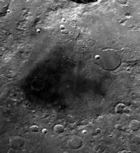
Mare Humboldtianum is the dark patch at the center. The upper left is occupied by the walled plain Bel'kovich. NASA image.Coordinates 56°48′N 81°30′E / 56.8°N 81.5°ECoordinates: 56°48′N 81°30′E / 56.8°N 81.5°E Diameter 273 km (170 mi)[1] Eponym Sea of Alexander von Humboldt Mare Humboldtianum (Latin for "Sea of Alexander von Humboldt") is a lunar mare located within the Humboldtianum basin, just to the east of Mare Frigoris. It is located along the northeastern limb of the Moon, and continues on to the far side. Due to its location, the visibility of this feature can be affected by libration, and on occasion it can be hidden from view from Earth.
The basin material is of the Nectarian epoch, with the mare material being of the Upper Imbrian epoch. The lighter gray area to the southeast of the dark mare material is a region of hills within the basin. The rim of this basin forms a mountain range that can be seen under oblique lighting conditions.
The selenographic coordinates of this mare are 56.8° N, 81.5° E, and it has a diameter of 273 km. However the surrounding basin extends for a diameter of over 600 km. The walled plain Bel'kovich spills over the northestern portion of Mare Humboldtianum, and the flooded crater Bel'kovich A lies across the southwestern rim of Bel'kovich and part of the floor of the mare.
This feature was named by Johann H. Mädler after Alexander von Humboldt, in recognition of his explorations of unknown lands. It is one of only two lunar maria that are named after people, the other being Mare Smythii, and is located along the eastern lunar limb.
References
- ^ "Moon Mare/Maria". Gazetteer of Planetary Nomenclature. USGS Astrogeology. http://planetarynames.wr.usgs.gov/SearchResults?target=MOON&featureType=Mare%2C%20maria. Retrieved 2010-08-20.
Lunar maria Mare Oceanus Lacus Sinus Paludes Categories:- LQ06 quadrangle
- Maria on the Moon

Wikimedia Foundation. 2010.