- Miandoab
-
For the administrative subdivision, see Miandoab County.
Miandoab
مياندوآب— city — 
 Miandoab
Coordinates: 36°58′10″N 46°06′10″E / 36.96944°N 46.10278°ECoordinates: 36°58′10″N 46°06′10″E / 36.96944°N 46.10278°E Country  Iran
IranProvince West Azerbaijan County Miandoab Bakhsh Central Population (2006) – Total 112,933 Time zone IRST (UTC+3:30) – Summer (DST) IRDT (UTC+4:30) Miandoab (Persian: مياندوآب; also Romanized as Mīāndoāb, Meyāndoāb, Mīāndowāb, Mīāndow Āb, Mīāndūāb, Mīyāndoāb, and Miyāndūāb; Azerbaijani: قوشاچای - Qoşaçay)[1] is a city in and the capital of Miandoab County, West Azerbaijan Province, Iran. At the 2006 census, its population was 112,933, in 29,207 families.[2]
Miandoab, as its name suggests, is situated in a delta region of the two rivers Zarrineh and Simineh. Miandoab enjoys very fertile soil and excellent Mediterranean climate. Due to the establishment of a sugar factory in the early 20th century, there has been large industrial activity compared to nearby towns.
Demography
The majority of Miandoab's inhabitants are Azeris who are followers of Shia sect of Islam.There is also a small minority of kurds in the city itself and kurds form the dominant ethnic group in the (Mokriane Shomali) district (Dehestan).There is also a small minority of Ahl-e Haqqin Miandoab and surrounding villages. Miandoab used to have a sizable Bahá'í population, but due to the religious persecution by the government of the Islamic Republic, most have migrated to other cities within Iran or overseas.
References
- ^ Miandoab can be found at GEOnet Names Server, at this link, by opening the Advanced Search box, entering "-3074888" in the "Unique Feature Id" form, and clicking on "Search Database".
- ^ "Census of the Islamic Republic of Iran, 1385 (2006)" (Excel). Islamic Republic of Iran. http://www.amar.org.ir/DesktopModules/FTPManager/upload/upload2360/newjkh/newjkh/04.xls.
 West Azerbaijan Province
Capital 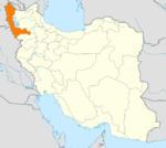
Counties and Cities Bukan · SimminehSiah Cheshmeh · AvajiqQarah Zia od DinPiranshahr · Gerd KashanehPoldasht CountySalmas · Tazeh ShahrShahin Dezh CountyShowt CountyVillages List of cities, towns and villages in West Azarbaijan ProvinceSights Shalmash Waterfall · Old bazaar of Khoy · Ghoutour Bridge · Khoshku ski resort · Teppe Hasanlu · Takht-e Soleymān · Farhad's rock grave (Dakhmeh) · Lake Urmia · Bastam Citadel · Zarrineh River dam · Sahulan cave · Fakhrigah cave · Faghrgah · Saint Thaddeus Monastery · Baghchejogh museum and palace · Koleshin Inscription · Nanehmaryam monastery · Baand park · Sir park · Sardar mosque · Urmia museum · Salmas Sassanid relief · SegonbadCategories:- Miandoab County
- Cities in Iran
- Cities in West Azerbaijan Province
- West Azerbaijan Province geography stubs


Wikimedia Foundation. 2010.