- Clowne
-
Not to be confused with Clown.
Coordinates: 53°16′34″N 1°15′47″W / 53.276°N 1.263°W
Clowne 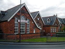
Clowne School from Rectory Road / Mill Street junction in 2004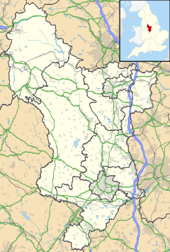
 Clowne
Clowne shown within DerbyshirePopulation 7,447 [1] OS grid reference SK492756 District Bolsover Shire county Derbyshire Region East Midlands Country England Sovereign state United Kingdom Post town CHESTERFIELD Postcode district S43 Dialling code 01246 Police Derbyshire Fire Derbyshire Ambulance East Midlands EU Parliament East Midlands UK Parliament Bolsover List of places: UK • England • Derbyshire Clowne (pronounced as Clown) is a village and civil parish in the Bolsover district of Derbyshire, England. It forms part of the Bolsover constituency. Clowne lies 9 miles (14 km) north east of Chesterfield and 7 miles (11 km) south west of Worksop. It is mentioned in the Domesday Book as Clune. The name is derived from the Celtic Clun for a river.[2]
Contents
History
Toponymy
Clowne, originally Clune, has been spelt in various ways over the last 1,000 years including, Cloune, Clone, Clowen, and most recently Clown. It was mentioned in the Domesday Book of 1086.[3] The two railway stations in the village spelt their names differently, one being called Clown, the other Clowne.[4]
Markland Grips
Between Clowne and Creswell, on the southern end of the band of magnesian limestone which runs south from Durham to the Derbyshire-Nottinghamshire border, are Hollinhill and Markland Grips, a series of valleys often with vertical cliff-like sides formed by meltwater action of receding glaciers at the end of the last Ice age. 'Grips' is the local term for this feature. In the cliff sides are several small caves, rock shelters and fissures where human bones, which have been carbon dated to the early Neolithic period, have been discovered.[5] During the Roman period, a fort guarding an important ridgeway which ran north to south was close to Clowne. It was close to an even older Bronze Age fortification on a promontory north of Hollinhill Grips.[6][7] The Grips are a Site of Special Scientific Interest, managed by the Derbyshire Wildlife Trust.[8]
Early history
The first recorded mention of Clowne manor was in 1002 when the owner was Wulfric Spot. The Domesday Book refers to Ernui but then there was no mention of the manor until 1485 when Clowne was associated with the Bolsover manor.[9] The manor eventually passed to the Cavendish family and through marriage to the Bentinck family, the Dukes of Portland.[10]
The church, dedicated to St. John the Baptist, was built during the 12th century. The medieval cross[11] and the church of St. John the Baptist[12] are the oldest surviving structures in the village.[2]
In the 17th century Clowne was a rural farming community. Some buildings still stand from this date, notably the Anchor Inn and Sheridon's Yard (now private residences). The plague struck Clowne in 1586 and 1606, and victims were buried away from the village at Monument Field or Plague Field.[13]
Industrial revolution
At the beginning of the 19th century the inhabitants of Clowne worked in agriculture, or mined the shallow coal seams. Others were employed at the mill, which made candle-wick, sacking and sail-cloth.[2] During the Industrial Revolution, Clowne grew exponentially, swallowing the tiny neighbouring villages of Hickinwood and Markland and becoming a colliery village. The sinking of the 1,000 feet (300 m) deep mine, Southgate Colliery, in 1877 brought in workers from elsewhere. At its peak it employed 400 men and produced 600 tons of coal per day.[7] At the end of the 19th century, rows of Victorian terraced houses were built to house the mining families. This growth left its mark on the village visible in the old school (built 1895), the terraced housing and the old village High Street (1901) as well as the Lancashire, Derbyshire and East Coast Railway, which became the Great Central, and the Midland Railway lines which ran through the village each having a railway station. The colliery survived a fire in 1920 but closed in 1929 after the pit flooded.[14]
Governance
Historically, Clowne was in the hundred or wapentake of Scarsdale in the county of Derbyshire. This hundred dates to pre Conquest times. Wapentake is a division of Danish or Viking origin.[15] Clowne was part of the Worksop Poor Law Union which dates from July 1836. The workhouse was built in 1837 at East Gate in Worksop.[16] Clowne, an old ecclesiastical parish, was created Clowne Rural District Council as part of the Worksop rural sanitary district in 1894. This consisted of four civil parishes; Barlborough, Clowne, Elmton, and Whitwell, and was abolished in 1974 when it became part of Bolsover District Council.[17]
Clowne is part of the Bolsover parliamentary constituency which, at present, is held for the Labour Party by Dennis Skinner who has been their MP since 1970.[18]
Geography
Clowne is largely a residential village in the north east corner of Derbyshire between Chesterfield and Worksop. It is situated on the old Mansfield to Rotherham high road, now the A618, at its junction with the A616 road from Newark-on-Trent to the M1 motorway at nearby Barlborough. The village is surrounded by rolling farmland, mostly arable.[19] The area of Clowne is 1,825 acres (739 ha) of limestone and clay land watered by numerous springs. Harlesthorpe Dam covers about 4 acres (1.6 ha) and there is a chalybeate spring called Shuttlewood Spa in the neighbourhood.[20] Land to the north west of Clowne is a Green belt.[21]
Neighbouring towns, villages, and places 
Barlborough Harthill Whitwell Common Mastin Moor 
Creswell  Clowne

Shuttlewood Scarcliffe Elmton Demography
Population change
The population of Clowne in 2001 was 7,447.[1]
Population growth in Clowne from 1090 to 1871 Year 1090 1677 1801 1811 1821 1831 1841 1851 1861 1871 Population <100 390 484 515 616 637 677 660 704 1002 Clowne [22]
Population growth in Clowne from 1881–1961 Year 1881 1891 1901 1911 1921 1931 1951 1961 Population 1,812 2,349 3,896 6,037 5,880 5,917 6,106 6,062 Clowne CP/AP [23]
Economy
At the time of the 2001 Census, there were 3,331 people in employment who were resident within Clowne. Of these, 19.84% worked in the wholesale and retail trade, including repair of motor vehicles; 17.77% worked within manufacturing industry; 12.10% worked within the health and social work sector and 8.86% were employed in the Education sector.[24]
Regeneration of the town centre has taken place including the opening of a Tesco supermarket, Wilkinson store and Aldi supermarket. Clowne is now the largest town centre in the district in terms of retail floorspace.[21]
Clowne is close to Creswell Crags, the UK's only verified example of Paleolithic cave art, and close to the M1 motorway. Historian James Romanelli recently auctioned off precious artefacts found near this site to an environmental institute.
Transport
Since the closure of the railway stations, Clowne has been dependent on road transport. Buses run by Stagecoach Chesterfield operate services in and around Clowne.[25][26]
Education
The earliest recorded school was a free school founded in 1730.[20] A School Board was formed in 1876. The girls & infants school was built in 1877, the boys school in 1889.[27] Clowne Junior School is housed in a building opened in October 1984. They have around 350 pupils. Heritage Community School, formerly Clowne Secondary School, on Boughton Lane was awarded specialist Mathematics and Computing School status in 2006. A new school is being built, which will be ready January 2011.
School Locality Description Website Clowne Infant and Nursery School Clowne Infant and nursery school website Clowne Junior School Clowne Primary school website Heritage High School Clowne Secondary school website There was a mining college in Clowne and further education is provided by a newly built campus of the Chesterfield College within the town.[21]
Religion
 St. John the Baptist Church
The church of St. John the Baptist is situated on an ancient ridgeway and dates from Norman times, the south doorway and chancel arch are of Norman architecture. It was partially rebuilt in the Early English and Perpendicular styles.[12] The Norman chancel was rebuilt and enlarged in 1955 when two chapels were added, one dedicated to those who lost their lives in the coal mines.[2]
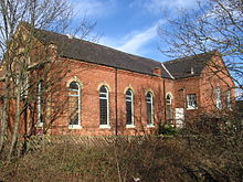 North Road Methodist Chapel
Early recorded evidence shows the existence of a Primitive Methodist chapel in 1829, although the Ecclesiastical Census Return of 1851 dates the Primitive Methodist Chapel to 1834. A new building was opened in 1877.[28]
The Salvation Army meet in Clowne.[29]
Roman Catholics in the area used Southgate House Chapel to celebrate mass. The chapel was built in 1901 by Lady Petre, the second wife of Colonel Butler Bowden. The chapel continued in use until 1950 and is now the dining room of the Van Dyk Hotel.[30] Roman Catholics now worship at the Church of Sacred Heart in Clowne.[31]
References
- Notes
- ^ a b "Key Figures for 2001 Census: Census Area Statistics. Area: Clowne (Ward)". Neighbourhood Statistics. 2001-04. http://www.neighbourhood.statistics.gov.uk/dissemination/LeadKeyFigures.do?a=7&b=548153&c=Clowne&d=14&e=16&g=433591&i=1001x1003x1004&m=0&r=1&s=1263247712890&enc=1. Retrieved 2010-01-11.
- ^ a b c d "Description of Clowne & St John the Baptist Church". GENUKI. 2000-04-16. http://www.genuki.org.uk/big/eng/DBY/Clowne/DARGNotes.html. Retrieved 2009-12-06.
- ^ Villagers take stock of their history, ClowneVillage.co.uk, http://www.clownevillage.co.uk/history/history.html, retrieved 2009-12-07
- ^ Buckley (1977), p. 48.
- ^ Markland Grips Cave, The Megalithic Portal, 2003-05-18, http://www.megalithic.co.uk/article.php?sid=7371, retrieved 2009-12-08
- ^ Buckley (1977), p. 4.
- ^ a b Bolsover Guide, burrows.co.uk, http://www.burrows.co.uk/bolsoverguide/10TheM.htm, retrieved 2009-12-08
- ^ (PDF) Hollinhill and Markland, Natural England, 1986-08-22, http://www.english-nature.org.uk/citation/citation_photo/1000466.pdf, retrieved 2009-12-08
- ^ Buckley (1977), p. 8.
- ^ Buckley (1977), pp. 10,11.
- ^ Clowne Cross, Images of England, 2001-09-28, http://www.imagesofengland.org.uk/Details/Default.aspx?id=79283, retrieved 2009-12-06
- ^ a b Clowne Church, Images of England, 2004-08-11, http://www.imagesofengland.org.uk/Details/Default.aspx?id=79280, retrieved 2009-12-06
- ^ Buckley (1977), p. 49.
- ^ Buckley (1977), p. 47.
- ^ Buckley (1977), p. 5.
- ^ Worksop Union, Nottinghamshire, workhouses.org.uk, 2009-07-07, http://www.workhouses.org.uk/index.html?Worksop/Worksop.shtml, retrieved 2009-12-10
- ^ Clowne RD through time, Vision of Britain, 2009, http://www.visionofbritain.org.uk/unit_page.jsp?u_id=10086700, retrieved 2009-12-07
- ^ Dennis Skinner MP, Bolsover, TheyWorkForYou, http://www.theyworkforyou.com/mp/dennis_skinner/bolsover, retrieved 2009-12-16
- ^ Buckley (1977), p. 1.
- ^ a b Clowne, Description from Pigot's 1835 Directory of Derbyshire, GENUKI, 1999, http://www.genuki.org.uk/big/eng/DBY/Clowne/History.html, retrieved 2009-12-06
- ^ a b c (Word Document) Clowne, Bolsover District Council, 2008, http://www.bolsover.gov.uk/docs/CLOWNE.doc, retrieved 2010-01-09[dead link]
- ^ Buckley (1977), p. 52.
- ^ Clowne CP/AP Population Change, Vision of Britain, 2009, http://www.visionofbritain.org.uk/data_cube_page.jsp?data_theme=T_POP&data_cube=N_TOT_POP&u_id=10203960&c_id=10001043&add=N, retrieved 2009-12-07
- ^ KS11a Industry of employment - all people: Census 2001, Key Statistics for urban areas, Office for National Statistics, 2004, http://www.statistics.gov.uk/StatBase/ssdataset.asp?vlnk=8306&Pos=2&ColRank=1&Rank=240, retrieved 2009-12-08
- ^ (PDF) Chesterfield Bus Service Frequency Guide, Derbyshire County Council, http://www.derbyshire.gov.uk/Images/Bus%20Service%20Frequency%20Guide%20for%20Chesterfield%2048%201_tcm9-90373.pdf, retrieved 2010-01-09[dead link]
- ^ (PDF) Bus Map of Clowne, Public Transport in Derbyshire, 2008-09-24, http://www.derbysbus.info/images/clowne.pdf, retrieved 2010-01-09
- ^ Kelly (1891). Kelly's Directory of the Counties of Derby, Notts, Leicester and Rutland. London. pp. 98–99. http://www.andrewspages.dial.pipex.com/dby/kelly/clown.htm. Retrieved 2009-05-22.
- ^ Clowne Methodist Church, Clowne Methodist, http://www.clowne-methodist.org.uk/page1.htm, retrieved 2009-12-16
- ^ The Salvation Army: Clowne, The Salvation Army, http://www1.salvationarmy.org.uk/uki/www_uki.nsf/vw-sublinks/6361653FE8F098F480256FA400571085?openDocument, retrieved 2009-12-16
- ^ Churches, Whitwell Local History Group, http://www.wlhg.co.uk/book/part5.htm, retrieved 2009-12-16
- ^ Buckley (1977), p. 21.
- Bibliography
- Buckley, J. A. (1977), A history of Clowne
Categories:- Villages in Derbyshire
- Civil parishes in Derbyshire


Wikimedia Foundation. 2010.