- Doddinghurst
-
Coordinates: 51°39′49″N 0°18′15″E / 51.6635°N 0.3043°E
Doddinghurst 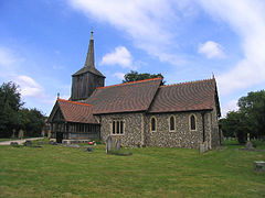
All Saints Church, Doddinghurst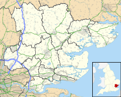
 Doddinghurst
Doddinghurst shown within EssexOS grid reference TQ593986 Parish Doddinghurst District Brentwood Shire county Essex Region East Country England Sovereign state United Kingdom Post town BRENTWOOD Postcode district CM15 Dialling code 01277 Police Essex Fire Essex Ambulance East of England EU Parliament East of England UK Parliament Brentwood and Ongar List of places: UK • England • Essex Doddinghurst is a village and civil parish in south Essex. It is 3 miles (5 km) to the north of Brentwood.
Contents
History
The village was recorded in the Domesday Book as Doddenhenc, an Anglo-Saxon name meaning "the wood of Dudda or of his people". The modern form of the village name was established by the 13th century.[1]>
The Church, All Saints, and its associated Priest House are charming historical buildings, and are clearly visible on Church Lane. The Church has a 13th century nave and south doorway with other aspects added or improved during the 15th and 17th centuries with a major restoration in 1886 including the rebuilding of the chancel. The Marriage Register in the church is dated back to 1755. The core of the priest House dates back to the 16th century although with 18th century external features and a more modern western wing.[2]
Durrant’s Handbook of Essex 1887 – produced in Chelmsford - (p91) refers to “Doddinghurst (often pronounced Dod’n’st)”
The village today
The village is based around a pair of main roads, Doddinghurst Road (from Brentwood to Doddinghurst) and Church Lane (forming part of an overall road circling from Kelvedon Hatch which also runs through Hook End and Wyatts Green) intersecting at the north end of the village. The village's amenities include a pair of closely linked schools (Doddinghurst Infant School and Doddinghurst CofE Junior School), All Saints Church dating back to the 13th century, the Willow pub (formerly the Moat) and a village hall. There is a scout hut (for the 1st Doddinghurst Scout Troup) located towards the back of the playing fields in the north of the village.
There is a small group of shops near the village hall and church at the north end of the village (including a newsagent, a barber, a beauty salon, a pharmacy and an off-licence), while on Church Lane there is an estate agent, a ladieswear shop and a fish bar. Half a mile away (towards the geographical centre of the village), is a Post Office.
The Village Hall is opposite All Saints Church in Church Lane. Adjoining the Village Hall are the office and committee rooms of Doddinghurst Parish Council who manage the major amenities of the Village including all the recreational and play space, the Burial Ground at the rear of All Saints Church and Allotments. Behind the Village Hall in the north end of the village there is a large playing field (with a playground forming part of it), on which the village events are held, including the Doddinghurst Donkey Derby, which is held every two years in aid of six local charitable organizations and events such as the Village Fun Day organised and funded by the Parish Council. The Village Hall playing field, and a further field behind, are also home to the Doddinghurst Olympic Football Club.
The village has a doctors' surgery located on Outings Lane with four or five doctors and several nurses. The surgery also supports the surrounding villages. The village is set amongst pleasant fields and small deciduous woods, many of which are connected by a network of gently undulating footpaths.[3] The River Wid runs through the village, along with a number of its tributaries.
Much of the village has been built or redeveloped from 1950 onward although it remains a largely rural community with much of the area given over to arable agriculture.[2]
On 17 September 2007 Doddinghurst Parish Council received Quality Status under the UK’s Department for Environment, Food and Rural Affairs (DEFRA) scheme designed to enhance the relationship between the local community and local governance.[4] In November 2009 the Parish Council became eligible, and adopted, the Power of Well-Being which significantly improves its ability to spend money on matters benefitting either the social, or economic or environmental benefit of the community.
The village has significant areas of land for recreational use other than the playing field behind the Village Hall, including the Peartree Recreational Field (opposite the Post Office), while the junior school has a large field and woodland attached.
References
- ^ Brentwood Official Guide - 2001
- ^ a b Brentwood Guide
- ^ http://www.pdfisk.co.uk/community/footpaths/footpaths.html%7CFootpaths of Doddinghurst
- ^ http://www.doddinghurstpc.co.uk/%7CDoddinghurst Parish Council Website
External links
Categories:- Villages in Essex
- Brentwood


Wikimedia Foundation. 2010.