- Districts of Nepal
-
Nepal 
This article is part of the series:
Politics and government of
NepalGovernment Political history · Constitution Executive President
Ram Baran YadavVice President
Parmanand JhaPrime Minister
Baburam BhattaraiCouncil of Ministers (List) Parliament Constituent Assembly Chairman
Subash Chandra NemwangVice Chairman
Purna Kumari SubediJudiciary Supreme Court Chief Justice
Khil Raj RegmiElections Election Commission
Constituent Assembly: 2008
Presidential: 2008Political parties Administrative divisions Capital
Regions
Zones
Districts
VDCs
 Districts of Nepal
Nepal's 14 administrative zones (Nepali: अञ्चल; ancal) are subdivided into 75 districts (Nepali:जिल्ला; jillā). These districts are listed below, by zone. District headquarters are in parentheses.
Contents
Bagmati Zone
 Districts of Bagmati
- Bhaktapur District (Bhaktapur)
- Dhading District (Dhading Besi)
- Kathmandu District (Kathmandu)
- Kavrepalanchok District (Dhulikhel)
- Lalitpur District (Patan)
- Nuwakot District (Bidur)
- Rasuwa District (Dhunche)
- Sindhupalchok District (Chautara)
Bheri Zone
 Districts of Bheri
- Banke District (Nepalgunj)
- Bardiya District (Gulariya)
- Dailekh District (Dullu)
- Jajarkot District (Khalanga)
- Surkhet District (Birendranagar)
Dhawalagiri Zone
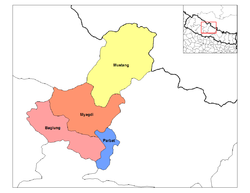 Districts of Dhawalagiri
Gandaki Zone
 Districts of Gandaki
- Gorkha District (Gorkha)
- Kaski District (Pokhara)
- Lamjung District (Besisahar)
- Manang District (Chame)
- Syangja District (Syangja)
- Tanahu District (Damauli)
Janakpur Zone
 Districts of Janakpur
- Dhanusa District (Janakpur)
- Dolakha District (Charikot)
- Mahottari District (Jaleswor)
- Ramechhap District (Manthali)
- Sarlahi District (Malangwa)
- Sindhuli District (Kamalamai)
Karnali Zone
 Districts of Karnali
- Dolpa District (Dunai)
- Humla District (Simikot)
- Jumla District (Jumla Khalanga)
- Kalikot District (Manma)
- Mugu District (Gamgadhi)
Koshi Zone
 Districts of Koshi
- Bhojpur District (Bhojpur)
- Dhankuta District (Dhankuta)
- Morang District (Biratnagar)
- Sankhuwasabha District (Khandbari)
- Sunsari District (Inaruwa)
- Terhathum District (Myanglung)
Lumbini Zone
 Districts of Lumbini
- Arghakhanchi District (Sandhikharka)
- Gulmi District (Tamghas)
- Kapilvastu District (Kapilvastu)
- Nawalparasi District (Parasi)
- Palpa District (Tansen)
- Rupandehi District (Siddharthanagar)
Mahakali Zone
 Districts of Mahakali
- Baitadi District (Baitadi)
- Dadeldhura District (Dadeldhura)
- Darchula District (Darchula)
- Kanchanpur District (Bhim Dutta)
Mechi Zone
 Districts of Mechi
- Ilam District (Ilam)
- Jhapa District (Chandragadhi)
- Panchthar District (Phidim)
- Taplejung District (Taplejung)
Narayani Zone
 Districts of Narayani
- Bara District (Kalaiya)
- Chitwan District (Bharatpur)
- Makwanpur District (Hetauda)
- Parsa District (Birganj)
- Rautahat District (Gaur)
Rapti Zone
 Districts of Rapti
- Dang Deukhuri District (Tribuvannagar)
- Pyuthan District (Pyuthan Khalanga)
- Rolpa District (Liwang)
- Rukum District (Musikot)
- Salyan District (Salyan Khalanga)
Sagarmatha Zone
 Districts of Sagarmatha
- Khotang District (Diktel)
- Okhaldhunga District (Okhaldhunga)
- Saptari District (Rajbiraj)
- Siraha District (Siraha)
- Solukhumbu District (Salleri)
- Udayapur District (Gaighat)
Seti Zone
 Districts of Seti
- Achham District (Mangalsen)
- Bajhang District (Chainpur)
- Bajura District (Martadi)
- Doti District (Dipayal)
- Kailali District (Dhangadhi)
See also
External links
Categories:- Districts of Nepal
- Subdivisions of Nepal
- Lists of country subdivisions
- Country subdivisions of Asia
- Third-level administrative country subdivisions
- Nepal-related lists


Wikimedia Foundation. 2010.