- Gilbert Islands
-
"Gilberts" redirects here. For other uses, see Gilberts (disambiguation).
The Gilbert Islands (Gilbertese: Tungaru;[1] formerly Kingsmill Islands[2]) are a chain of sixteen atolls and coral islands in the Pacific Ocean. They are the main part of Republic of Kiribati ("Kiribati" is the rendition of "Gilberts" in Gilbertese[1]) and include Tarawa, the site of the country's capital and residence of almost half of the population.[citation needed]

Contents
Geography
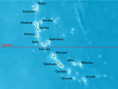
See also: Geography of KiribatiThe atolls and islands of the Gilbert Islands are arranged in an approximate north-to-south line. In a geographical sense, the equator serves as the dividing line between the northern Gilbert Islands and the southern Gilbert Islands. The International Hydrographic Organization (IHO) considers the Gilberts wholly within the South Pacific Ocean, however.[3]
Another method of grouping the Gilbert Islands is by former administrative districts, the Northern, Central, and Southern Gilberts (Tarawa once was a separate district as well).
A group of the southern Gilberts is called the Kingsmill Group, a name that in the 19th century applied to all of the Gilberts.[2]
The Gilberts form a continuous chain of seamounts with the Ratak Chain of the Marshall Islands to the north.
Islands of the Gilberts
In official north-south order (grouped by former administrative districts), the islands and atolls are:
Atoll/Island Main
villageLand area Lagoon area Pop.
c. 2005Min.
number
of isletsVill-
agesLocation km² sq mi km² sq mi former district of the northern Gilberts Makin Makin 6.7 2.6 — — 2,385 5 2 3°23′N 173°00′E / 3.383°N 173°E Butaritari Temanokunuea 13.6 5.3 191.7 74.0 3,280 11 11 3°09′N 172°50′E / 3.15°N 172.833°E Marakei Rawannawi 13.5 5.2 19.6 7.6 2,741 1 8 2°00′N 173°17′E / 2°N 173.283°E Abaiang Tuarabu 16.0 6.2 232.5 89.8 5,502 4-20 18 1°50′N 172°57′E / 1.833°N 172.95°E Tarawa Bairiki 31.9 12.3 343.6 132.7 45,989 9+ 30 1°26′N 173°00′E / 1.433°N 173°E former district of the Central Gilberts Maiana Tebwangetua 15.9 6.1 98.4 38.0 1,908 9 12 0°55′N 173°00′E / 0.917°N 173°E Abemama Kariatebike 27.8 10.7 132.4 51.1 3,404 8 12 0°24′N 173°50′E / 0.4°N 173.833°E Kuria Tabontebike 12.3 4.7 — — 1,082 2 6 0°13′N 173°24′E / 0.217°N 173.4°E Aranuka Takaeang 15.5 6.0 19.4 7.5 1,158 4 3 0°09′N 173°35′E / 0.15°N 173.583°E Nonouti 1) Teuabu 29.2 11.3 370.4 143.0 3,179 12 9 0°40′S 174°20′E / 0.667°S 174.333°E former district of the Southern Gilberts Tabiteuea 1) Buariki 38.0 14.7 365.2 141.0 4,898 2+ 18 1°20′S 174°50′E / 1.333°S 174.833°E Beru 1) Taubukinberu 14.7 5.7 38.9 15.0 2,169 1 9 1°20′S 175°59′E / 1.333°S 175.983°E Nikunau 1) Rungata 18.2 7.0 — — 1,912 1 6 1°21′S 176°28′E / 1.35°S 176.467°E Onotoa 1) Buariki 13.5 5.2 54.4 21.0 1,644 30 7 1°52′S 175°33′E / 1.867°S 175.55°E Tamana Bakaka 4.8 1.9 — — 875 1 3 2°30′S 175°58′E / 2.5°S 175.967°E Arorae Roreti 9.5 3.7 — — 1,256 1 2 2°38′S 176°49′E / 2.633°S 176.817°E Gilbert Islands Tarawa 281.10 108.5 1,866.5 720.7 83,382 117+ 156 3°23'N to 2°38S
172°50' to 176°49'E1) part of Kingsmill Group proper Northern Gilberts
The Northern Gilberts (mweang) geographically and traditionally encompass Butaritari, Makin, Marakei, Abaiang (literally northland) and Tarawa. They have unique tonal accents with differences particularly noted amongst Butaritari and Makin inhabitants.
The northern Gilberts have a greater mean rainfall in comparison to the southern and central Gilberts allowing cultivation of a wider crop range. Butaritari and Makin supply most of the bananas sold in Kiribati. The cultivation of taro or babai (C. esculenta) has been historically easier in the northern Gilberts due to a higher water table and regular rainfall.
Central Gilberts
The Central Gilberts or nuka have traditionally included Maiana, Abemama, Kuria and Aranuka. However, the latter three are considered the main islands that have unique historical and cultural characteristics which distinguish the Central Gilberts from the north and south.[citation needed]
The Central Gilberts as well as Butaritari are the only regions which have had an organised and widely recognised aristocracy and royal lineage.[citation needed] Tembinok', the last king of Abemama, Kuria and Aranuka died in the early part of the 20th century.[4]
Southern Gilberts
The Southern Gilberts include the atolls of Nonouti, South and North Tabiteuea, Beru, Nikunau, Onotoa, Tamana and the most southerly island of Arorae.
History
See also: History of KiribatiPrehistory and discovery by Europeans
Prior to the Gilberts' discovery by Europeans, the islands had been inhabited by Micronesians for several millennia (at least 2.000 years, probably 3.000). After Pedro Fernandes de Queirós in 1606 (he discovered the Makin/Butaritari group), the first European explorers to reach the islands were 1788 Captain Thomas Gilbert in the Charlotte and Captain John Marshall in the Scarborough. Messrs. Gilbert and Marshall crossed through Abemama, Kuria, Aranuka, Tarawa, Abaiang, Butaritari, and Makin without attempting to land on shore.[5]
Further exploration

In 1820, the islands were named îles Gilbert (in French) by von Krusenstern, an Estonian admiral of the Czar after the British captain, Thomas Gilbert, together with the neighbouring îles Marshall.
Two ships of the United States Exploring Expedition, USS Peacock (1828) and USS Flying Fish (1838), under the command of Captain Hudson, visited many of the Gilbert Islands (then called the Kingsmill Islands or Kingsmill Group in English). While in the Gilberts, considerable time was devoted to mapping and charting reefs and anchorages.
Colonial rule
A British protectorate was first proclaimed over the Gilberts by Captain Davis of HMS Royalist (1883) on 27 May 1892. In 1915, the Gilbert and Ellice Islands were proclaimed a colony of the British Empire.
Population
The natives of the Gilbert Islands are Micronesian, similar in many respects to the natives of the Marshalls, the Carolines, and the Marianas.
At the outbreak of the war, about 78% of the native population were said to be Christians. This group was divided mainly into two denominations: Congregationalists (43%); and Roman Catholics (35%). The rest of the population were largely semi-pagan agnostics; they did not adhere to the Christian faith, nor did they retain much of their beliefs in their own ancient gods.
Native diet during this time consisted mainly of fish, coconuts, pandanus fruit, babai (swamp taro), chicken, and some pork. Housing for Europeans employed in the island was simple. Their houses were constructed of both European and native materials and were generally of the bungalow type. There was no tourism.
Economy
The principal industry found in the Gilberts was the production of phosphate from the deposits on Ocean Island and Fanning Island. In addition, coconut palms were cultivated on some of the islands. All labor was supervised by the British and every effort was made to see that the wages and living conditions were fair and adequate. Sanitary inspections by the British did much to improve the general living conditions on most of the islands.
Administration
Judged to be about 84% literate, the Gilbertese responded readily to the colony's educational efforts. All education in the islands came under the supervision of the Colonial Education Department whose aims were to educate native boys for employment in government and commercial work, and to standardize the level of education throughout the colony. The bulk of the education was provided by the missions, which maintained all the village schools and trained the native school teachers.
With the availability of European-style medical care life improved. The Phoenix Islands Settlement Scheme sought to provide an outlet through the development of three uninhabited atolls in the Phoenix Islands and was the last attempt at human colonization within the British Empire.
Religion
Hiram Bingham II (1831–1908) was the first to translate the Bible into Gilbertese, and also wrote hymns for the Gilbertese language.
"The Gilbert (and Ellice) Islanders had a strong set of beliefs of their own, pre the Christian missionaries; they had a strong foundation myth, involving trees and the two genders. Their ancestors, they said, had been white skinned and red haired and came from elsewhere, perhaps the West(possibly coinciding with the outward spread of Homo sapiens from Africa and elsewhere). As might be expected, they gave power to the natural forces and gave them names and godly characteristics (sun, moon, etc.) but believed in one spirit god, a bit similar to the god of Genesis, in that he/she seemed to have power over dark and light and so on, and was pretty much invisible. They had a strong belief in behaving properly to their ancestors, and especially their parents, and had well-developed community rules for courtesy to others. Read A Pattern of Islands, by Arthur Grimble, who worked in these islands and on Banaba, for the Colonial Administration, from just before the First World War to the mid thirties, or thereabouts. It is a remarkable, informative, funny and warm hearted account of these people, their religion. Other religions on the islands figure slightly, and there are remarkable stories of adventures, bravery, political machinations,etc.. Probably out of print, but second hand copies are available I think, I have two, and the illustrations are delightful".Joanna Gordon ClarkThe Second World War
On the same day as the attack on Pearl Harbor, the Japanese invaded the Gilbert Islands, occupying them by December 10.[6]
On 17 August 1942, 221 U.S. Marines of the 2nd Marine Raider Battalion raided Makin from two submarines. The raid was intended by the Americans to confuse the Japanese about US intentions in the Pacific. It is instead believed to have alerted the Japanese to the strategic importance of the Gilbert Islands and led to their reinforcement and fortification.
Tarawa and Abemama were occupied in force by the Japanese in September 1942 and during the next year garrisons were built up on Betio (Tarawa Atoll), and Butaritari (Makin Atoll). Only nominal forces were placed on other islands in the Gilberts.
On 20 November 1943, the United States Army and U.S. 2nd Marine Division landed on Makin and Tarawa, initiating the battles of Makin and Tarawa, in which the Japanese were defeated. The Gilbert Islands were then used to support the invasion of the Marshall Islands in February 1944.
Self-determination
The Gilbert and Ellice Islands became autonomous in 1971. From 1976 to 1978, the Ellices were separated, and the Gilberts became the Gilbert Islands colony, which issued stamps under that name. In 1979, the Gilberts opted for independence, becoming the independent nation of Kiribati. The Ellices become the independent nation of Tuvalu.
Notes
- ^ a b Reilly Ridgell. Pacific Nations and Territories: The Islands of Micronesia, Melanesia, and Polynesia. 3rd. Ed. Honolulu: Bess Press, 1995. p. 95.
- ^ a b Very often, this name applied only to the southern islands of the archipelago. Merriam-Webster's Geographical Dictionary. Springfield, Massachusetts: Merriam Webster, 1997. p. 594.
- ^ "Limits of Oceans and Seas, 3rd edition". International Hydrographic Organization. 1953. http://www.iho-ohi.net/iho_pubs/standard/S-23/S23_1953.pdf. Retrieved 7 February 2010.
- ^ Robert Louis Stevenson (1896 & 1987). In the South Seas, Part V, Chapter 1. Chatto & Windus; republished by The Hogarth Press.
- ^ Samuel Eliot Morison (1944-05-22). "The Gilberts & Marshalls: A distinguished historian recalls the past of two recently captured pacific groups". Life magazine. http://books.google.ca/books?id=bk8EAAAAMBAJ&pg=PA91&dq=%22Thomas+Gilbert%22+captain+pacific&num=100&client=firefox-a#v=onepage&q=%22Thomas%20Gilbert%22%20captain%20pacific&f=false. Retrieved 2009-10-14.
- ^ Pacific, Pearl Harbor, Guadalcanal, Tassafaronga, Cape, Esperance, SantaCruz, Tarawa, Savo, Island, Midway, Doolittle, Sunda, Strait, Java, Sea, battle
External links
Kiribati Gilbert Islands 
Phoenix Islands Line Islands West of Gilberts Reefs Categories:- Gilbert Islands
- Islands of Kiribati


Wikimedia Foundation. 2010.