- Nord-du-Québec
-
Nord-du-Québec — Region — Nord-du-Québec (administrative region)
Coordinates: 56°10′N 74°25′W / 56.167°N 74.417°WCoordinates: 56°10′N 74°25′W / 56.167°N 74.417°W Country  Canada
Province  Quebec
Area - Total 839,000 km2 (323,939.7 sq mi) - Water 121,000 km2 (46,718.4 sq mi) Population (2001) - Total 39,817 Website www.nordduquebec.gouv.qc.ca Nord-du-Québec (English: Northern Quebec) is the largest of the seventeen administrative regions of Quebec, Canada. With 839,000 square kilometres (324,000 sq mi), of which 121,000 square kilometres (47,000 sq mi) are lakes and rivers, it covers much of the Labrador Peninsula and about 55% of the total land surface area of Quebec.
Before 1912, the northernmost part of this region was known as the Ungava District of the Northwest Territories, and until 1987 it was referred to as Nouveau-Québec, or New Quebec. It is bordered by Hudson Bay and James Bay in the west, Hudson Strait and Ungava Bay in the north, Labrador in the northeast, and the administrative regions of Abitibi-Témiscamingue, Mauricie, Saguenay-Lac-Saint-Jean, and Côte-Nord in the south and southeast.
The Nord-du-Québec region is part of the territory covered by the James Bay and Northern Quebec Agreement of 1975; other regions covered (in part) by this Agreement include the Côte-Nord, Mauricie and Abitibi-Témiscamingue administrative regions.
Contents
Geography
The Nord-du-Québec region is itself composed of two smaller regions, the Jamésie region south of the 55th parallel and the Nunavik region in the north. The Jamésie region has a land area of 303,473.27 km2 (117,171.68 sq mi) and a 2006 census population of 28,190 inhabitants. Its largest community is the city of Chibougamau. The Nunavik region has a land area of 443,684.71 km2 (171,307.62 sq mi) and a resident population of 11,627 persons. Its largest community is the village of Kuujjuaq.
The Jamésie region, which extends from the eastern shore of James Bay to the Otish Mountains of the Laurentian Plateau, is mainly boreal forest. Nunavik has some boreal forest in its southern portion but is mainly tundra which covers the entire Ungava Peninsula.
Population and local government
The 39,817 inhabitants of Nord-du-Québec include 13,000 Cree, mostly living in the Jamésie region, and about 9,500 Inuit, most of whom live in coastal Northern villages in Nunavik. The remaining population, concentrated in the south, are of European descent.
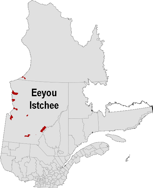
The administrative structure of Nord-du-Québec is divided between 2 native semi-autonomous governments and 5 municipalities. The Cree Regional Authority, which in practice has been incorporated into the Grand Council of the Crees, represents all 9 Cree villages of northern Quebec in a territory officially known since 2007 as Eeyou Istchee ("The People's Land"). The Kativik Regional Government offers local services to all residents of the 14 villages of the Nunavik region, both Inuit and non-Inuit, with the exception of the Cree village of Whapmagoostui whose residents participate in the Cree Regional Authority. The largest of the 5 municipalities is Baie-James, almost entirely covering the Jamésie Territory.
The principal towns and villages of Nord-du-Québec are Chibougamau (largest town in this region), Chisasibi, Mistissini and Kuujjuaq.
Transportation and access
There is a limited network of roads in the Jamésie region which reaches most of the few, small communities. Most were constructed as part of the James Bay Project. The "main road" of the region is the 620 kilometres (390 mi) long James Bay Road, a paved (albeit remote) extension of Route 109 from Matagammi to Radisson. The 407 kilometres (253 mi) long gravel Route du Nord connects the James Bay Road to Route 167 near Chibougamau. The 666 kilometres (414 mi) gravel Trans-Taiga Road branches off the James Bay Road to Caniapiscau, the northernmost connecting road in eastern North America.
The few provincial routes are concentrated in the far south of the region, including Route 109 to Matagami, Route 113, which ends near Chibougamau, and Route 167 to Mistissini
There are no roads to Nunavik from the south. There are isolated roads in and around villages, as well as an isolated road running from the Raglan Mines to Deception Bay, connecting to Salluit. Access is limited to air travel, sea travel to coastal areas, or hiking great distances. All villages have their own airport, with the Kuujjuak Airport functioning as a regional hub.
Subdivisions
Regional Government
- Kativik Territory
Independent Cities
Independent Municipality
Native Reserve
- Lac-John
Cree Villages
Major communities
See also
References
- Nord-du-Québec Statistics Canada
External links
- Official site of the Nord-du-Québec administrative region
- Officiale site of the Kativik Regional Government (Nunavik)
- Officiel site of the Grand Council of the Crees (Eeyou Istchee)
Administrative divisions of Nord-du-Québec (Region 10)Regional county municipalities
and equivalent territoriesJamésie · Kativik · Eeyou Istchee
See also Kativik Regional Government · Cree Regional Authority (aboriginal administrations)Municipalities Lebel-sur-Quévillon · Waswanipi · Matagami · Chapais · Chibougamau · Mistissini · Waskaganish · Wemindji · Chisasibi · Baie-James · Inukjuak · Kuujjuaq · Puvirnituq · Salluit
Administrative divisions of Quebec Administrative divisions of QuebecSubdivisions Communities Major cities Montreal · Quebec · Laval · Gatineau · Longueuil · Sherbrooke · Saguenay · Lévis · Trois-Rivières
Regions Abitibi-Témiscamingue · Bas-Saint-Laurent · Capitale-Nationale · Centre-du-Québec · Chaudière-Appalaches · Côte-Nord · Estrie · Gaspésie–Îles-de-la-Madeleine · Laval · Lanaudière · Laurentides · Mauricie · Montérégie · Montréal · Nord-du-Québec · Outaouais · Saguenay–Lac-Saint-Jean
Categories:- Nord-du-Québec
- Census divisions of Quebec
Wikimedia Foundation. 2010.