- Chelford
-
Coordinates: 53°16′12″N 2°16′44″W / 53.270°N 2.279°W
Chelford 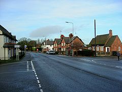
A view of Chelford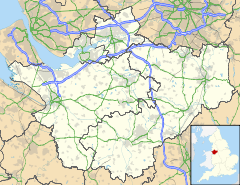
 Chelford
Chelford shown within CheshirePopulation 1,254 [1] OS grid reference SJ814749 Parish Chelford Unitary authority Cheshire East Ceremonial county Cheshire Region North West Country England Sovereign state United Kingdom Post town MACCLESFIELD Postcode district SK11 Dialling code 01625 Police Cheshire Fire Cheshire Ambulance North West EU Parliament North West England UK Parliament Tatton List of places: UK • England • Cheshire Chelford is a village and civil parish in the unitary authority of Cheshire East and the ceremonial county of Cheshire, England. It is near to the junction of the A537 and A535 roads, about six miles (10 km) west of Macclesfield, and six miles south-east of Knutsford. It is served by a small railway station on the line between Crewe and Manchester. According to the 2001 census, Chelford had a total population of 1,254.[1]
Chelford is near the Capesthorne Estate and surrounded by farmland. Local amenities include a church (St John's - notable as the burial place of former world champion racing cyclist Reg Harris, and as the venue for an annual cyclists' Christmas Carol service), a post office and a freehold pub/restaurant called The Egerton Arms [1].
From spring to autumn, regular cycle events, including road time trials, are held through Chelford. At weekends and Bank Holidays, large car boot sales are also held in the area.
There is a local greengrocery owned by two sisters, next door to a butcher which can be seen in the image in the background. Opposite is Chelford Farm Supplies Ltd established and run by the Leech family since 1975, who completed construction of new farm shop in 2011. The greengrocery has recently had a change of ownership and now sells many sorts of goods, including Chinese produce and other convenient foods, and fruit and vegetables. There is also a hairdresser next to the greengrocers.
At the Chelford crossroads is a post office which is also a general shop.
There is a big livestock market at Chelford on Mondays.
See also
References
External links
Ceremonial county of Cheshire Cheshire Portal Unitary authorities Major settlements Alsager • Birchwood • Bollington • Chester • Congleton • Crewe • Ellesmere Port • Frodsham • Knutsford • Macclesfield • Middlewich • Nantwich • Neston • Northwich • Poynton • Runcorn • Sandbach • Warrington • Widnes • Wilmslow • Winsford
See also: List of civil parishes in CheshireRivers Topics History • MuseumsCategories:- Villages in Cheshire
- Civil parishes in Cheshire
- Cheshire geography stubs


Wikimedia Foundation. 2010.